[Editor’s Note: This article was originally written and published in the June 2014 issue of Cycling Utah; references to dates and events are in accordance with that timeframe.]
By Mel Bashore — Two years ago, I set out on a solo loop ride from Ogden to Salmon, Idaho, and back. That was the year of the massive Mustang Complex wildfire in the Salmon-Challis National Forest in central Idaho. When I left my home in Utah, I knew about the fire, but there seemed to be little cause for concern. However when I reached Pocatello, I learned to my dismay that the fire was coming close to Salmon. Reports stated that the town was threatened with possible evacuation. There was heavy smoke in the area. It didn’t look good. On the fly I decided to divert from my plan to ride to Salmon and instead ride my bike to Yellowstone. It turned out to be a great alternative (see my article in Cycling Utah, March 2013 – download on cyclingwest.com).
While I enjoyed other rides in the intervening months, I kept thinking about this ride that I was forced to abandon in 2012. I was drawn to it like a raven to road kill. I had never been to that part of central Idaho. I had previously planned the route to take me on roads and to places where I had never been. In that way, it would be an adventure. And I love adventure.
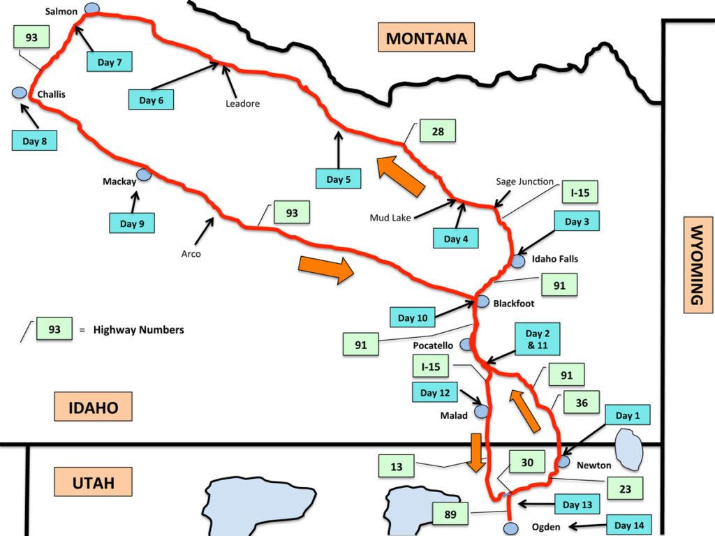
To get to Salmon, I had concocted this route that would take me north on little-traveled Idaho State Highway 28, passing between the Beaverhead Mountains and the Lemhi Range. After reaching Salmon, I would turn south, traveling through the Salmon-Challis National Forest on U.S. Highway 93.
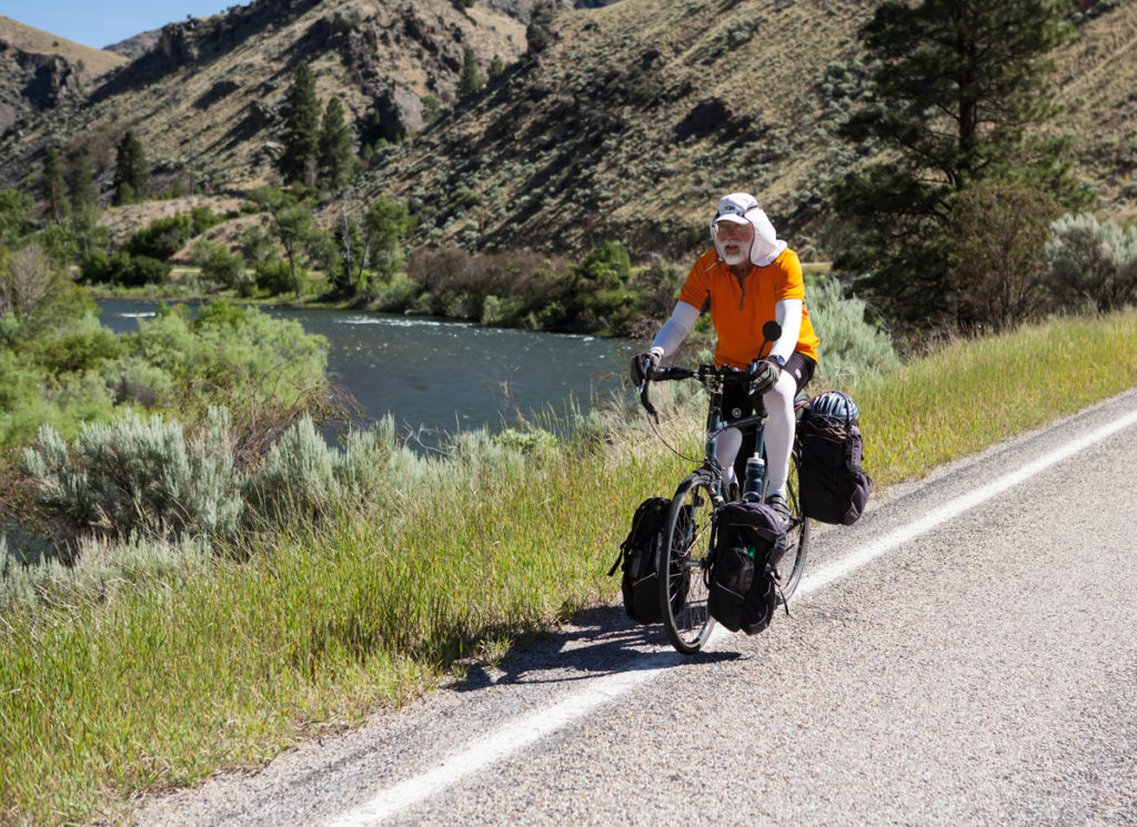
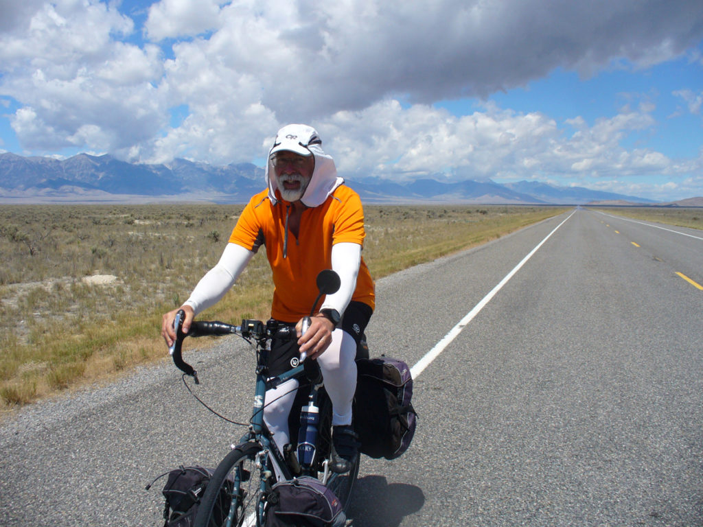
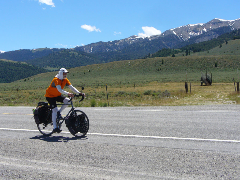
Although I would have preferred to begin the ride in late May for cooler riding conditions, I really wanted to attend my 50th high school reunion, so I had to delay my departure until late June. That later departure posed challenges and resulted in a couple of hard, hot days. But I also experienced some of the best biking days I have ever enjoyed—ever. And in talking with the locals, long distance bike tourers are a rarity on some of the prettiest and best biking parts of the journey. Thus follows an account of my two-week, 750-mile journey on roads less traveled in central Idaho.
Day 1—Ogden to Newton, Utah (64 miles)
I followed my 2012 route north from Ogden, traveling up the “Fruit Way” on Highway 89 through Willard and Perry to Brigham City.
I stopped for lunch at my favorite burger joint, the Dixie Grill. That has become a tradition for me for several long rides, which have taken me through northern Utah. I have become friends with the owners, Terry and Esther Davis. Besides serving really good barbecue, they enjoy seeing me and hearing about my long rides. When I pulled up to the order window, Esther said, “Where are you headed off to now?” I told her and said to look for me to return in about two weeks.
After a good lunch, I headed north through Honeyville and Deweyville to Collinston on State Highway 38. The volume of traffic on that back road is increasing, but it is still safe and reasonable on weekdays.
When I reached State Highway 30 just north of Collinston, instead of turning west to head to Malad, Idaho, like I did in 2012, I turned east and humped over Collinston Hill into Cache Valley. I decided to make my entry into Idaho through Cache Valley because I really enjoy the roads and quality biking conditions around that border crossing. They also pose less uphill than other approaches from Utah into Idaho.
After scooting down the east side of Collinston Hill, I turned north on State Highway 23. Bucking slight headwinds, I stopped in Newton’s town park for my first road camp.
Day 2—Newton, Utah, to McCammon, Idaho (66 miles)
After leaving Newton, I made my way north on State Highway 23 through the northern Utah towns of Trenton and Cornish. This is the kind of road where birds sing, people wave, and field sprinklers cool you down on a warm day. Delightful. After crossing the Utah-Idaho border, I traveled on Idaho State Highway 36 (or Westside Highway) through the friendly rural towns of Weston, Dayton, Clifton, and Oxford.
A few miles north of Oxford, the agricultural fields became more infrequent and isolated. The rural road stubbed into U.S. Highway 91, passing Downata Hot Springs and the retiring town of Downey, the latter humbled by its now-distant location from the stream of interstate freeway traffic several miles to the west. Highway 91 was nicely improved with wide bike shoulders all the way to the farming town of Virginia, Idaho. At Virginia, because it was getting on toward evening, I opted to travel on the I-15 freeway to my next road camp rather than take the old Highway 91 north. I had taken that old highway two years earlier. But in traveling on the freeway I could see the old highway essentially paralleled the freeway. In my foggy memory, I remembered it as not being so direct. I really didn’t need to have taken the freeway. The old highway would have worked just as well.
Nonetheless, I pulled into McCammon to look for a place to bed down. In asking around at its city park, someone remembered seeing passing bicyclists on occasion sleeping at a Mormon Church covered pavilion south of town. This sounded good as I had ridden through McCammon in 2012 and knew that lots of noisy trains passed through the town. It would be quieter at the church, which was more distant from the railroad tracks than the city park. That’s where I headed and was grateful for the overhead cover when it rained that night.
Day 3—McCammon to Idaho Falls, Idaho (78 miles)
In leaving McCammon, I simply followed the same back-road route I had taken in 2012. Just outside of town, on the north side of McCammon, I went east a short distance to Old Highway 91. I stopped at an Idaho Department of Transportation facility on the highway to make sure I was traveling on the right road that would take me north to Pocatello. One of the workers saw me pulling into their back lot and told his co-workers that it looked like the same biker he remembered seeing a few years earlier. If true, this speaks to how few bike tourers ride these roads—and to the memory of that man. They assured me that I was indeed on the right back road. They also wanted to make sure I had enough water and even wanted to give me an Idaho road crew florescent vest.
The morning ride through Inkom and Black Forge to Pocatello was as pleasurable as ever. The ride north from Pocatello to Chubbuck on Yellowstone Avenue (Highway 91) was as unsafe as I remembered. Two years ago I rode on the sidewalk because of the lack of shoulder, but this year orange barriers on the sidewalk prevented me from doing that for several miles. Fortunately weekday traffic was fairly light and I negotiated the stretch safely. As usual, dogs at houses in the Fort Hall Indian Reservation gave chase when I passed.
I reached Idaho Falls toward evening and found plenty of camping spots to pick from at the nice free grassy tourist park on the bank of the Snake River where I had camped before.
I was greeted by another fellow bike tourer also camped there. Jack Frost (his real name) was a disabled American veteran who hadn’t let his physical disabilities (seven failed knee surgeries and a bad back) prevent him from touring steadily for the past thirteen years on his bike. On this current stint, he had started eight months before from Key West, Florida, riding from there to San Diego, then to Bellingham, Washington, then to Portland, and from there to Idaho Falls. He had undergone three heart attacks and been a diabetic prior to taking up bike touring, but those health problems had been quashed. I camped next to him.
Day 4—Idaho Falls to Terreton, Idaho (42 miles)
Today I was pummeled all afternoon by heavy rain, wind, and hail. It was far from pleasant. When I left the tourist park, it was drizzling off and on. I ventured north on Yellowstone Avenue, turning west (left) on Broadway, passing through town and crossing the Snake River whereupon I turned north (right) on Utah Avenue. I had scoped out this road as a good way to venture northward and stay off the interstate. It was a good choice, giving me nice views of the Snake River and verdant farms for several miles. Passing cars were very infrequent. It was easy to follow despite the name changes to the road (Lindsay Blvd., North River Road, N3145 E., and Bassett Road) all the way to the small town of Roberts. At this place, I ate at a small café prior to getting on the I-15 freeway.
I had the option of taking a meandering frontage road on the west side of the interstate instead, but it would have been difficult to follow and quite lengthy. With the wind picking up and dark skies overhead, the short eight-mile freeway ride seemed the best choice.
As I set out, the rainstorm quickly developed in intensity. I was soaked before reaching a protecting overpass. I waited almost an hour for the rain to lessen before pushing ahead to Sage Junction. I exited the freeway here and headed west on State Highway 28. From there it was another race to search for shelter before the next wave of rain struck. I didn’t make it. I halted at a park across the street from the Mud Lake Market in Terreton. I camped that night under a leaky park pavilion, still grateful for some shelter.
Day 5—Terreton to Kaufman Camp Ground, along Birch Creek, Idaho (43 miles)
I took considerable time to dry things out before setting out in mid-morning. During the first couple of miles to the next town of Mud Lake, I saw two more covered pavilions that would have given good shelter. At Mud Lake, I veered right (northwest), continuing on State Highway 28. I left the farm fields behind in favor of dry sagebrush-covered ground spotted with periodic rodent mounds. One time I saw a badger run for cover into one of these ground holes. A passing local bicyclist told me that I was fortunate to not be faced that day with a headwind as that was common there. The road was mostly a gentle uphill climb.
Near the end of my riding day, I did face some strong headwinds in the draws above and below Lone Pine where I found a small café. Just north of those draws, the vista opened up again to the high 11-12,000-foot high mountains to the east and west of me. Many still had vestiges of melting snow on their north exposures.
That night I was the only person camped in the lush grasses of pretty Birch Creek at the Kaufman BLM camp—and it was a weekend. So far I had slept in some pretty comfortable locations, but this beat the band. I usually sleep in what I term “ditches”—and sometimes they really are. I must be getting soft in my old age.
Day 6—Kaufman Camp Ground to Leadore, Idaho (41 miles)
It was not easy leaving such a nice camp in this beautiful mountain setting. The road continued to climb with some long rollers, but it was not strenuous. All in all, the elevation gain from Mud Lake to Gilmore Summit, the highest point on Highway 28, was about 2,400 feet.
At the top of the summit, I halted to eat an apple and enjoy the view. While gazing about, an SUV pulled up. A mother (Shannon) and her son from Idaho Falls brought me an ice-cold bottle of water. How kind. She was also a bicyclist. She knew. There is a big difference in having plenty of water with you on bike tours and drinking water that is cold. A world of difference! I polished off the whole bottle of water before their vehicle was out of sight. I followed them at speed down the road. At one point on the descent, I got sideways on the gravel shoulder, just fishtailing my way back onto the pavement. Not good, but fortune smiled on me that time. Memo to Mel: Keep alert, attentive, and don’t get cocky.
After so many miles of good shoulders, the roughness of the road as it neared the town of Leadore was somewhat disagreeable. But that was forgotten after the enjoyable dinner I had in a bar in town (the best food is often served in bars in Idaho).
While there, a local rancher told me that bike tourers like me were rarely seen. He told me that the Mustang Complex fire didn’t get entirely squelched until deep into winter in December. He said that sometimes Idaho wilderness fires would burn underground in the roots all the way through winter and then burst into flame again in the spring. After eating, I went to their city park west of town where I camped for a nominal fee.
Day 7—Leadore to Shoup Bridge Recreation Site, south of Salmon, Idaho (54 miles)
This has to have been one of my best all-time biking days—ever! Perfect temperature. Perfect scenery. Perfect road. Perfect level of road—flat or slightly downhill. Cowboys out driving a herd of several hundred Angus cattle waving to me. But where were “my people” (my wife’s characterization of other long distance tourers sporting panniers)? Surely this couldn’t be a secret! It was too good—too biking good! This was one of those biking days you want to bottle up and repeatedly repeat, forever and ever. It didn’t hurt that the route was dripping in history: the national historic trails of Lewis and Clark and Nez Perce and the 1855 mission of Mormons sent to establish a fort in the Lemhi River valley.
To celebrate my 68th birthday on this day, I enjoyed a wonderful meal in Bertram’s Brewery, in an old building with an exquisite pressed-tin ceiling, in Salmon. It was all the best of the best.
After the meal, I turned south from Salmon on U.S. Highway 93, going five miles to Shoup Bridge Recreation Site, a small BLM camp next to the Salmon River. Before tucking myself in for the night, I took a chilly, but refreshing swim in the river. What a day!
Day 8—Shoup Bridge to Challis, Idaho (54 miles)
Another day in paradise! I traveled beside the Salmon River for almost forty miles. Shoulders were adequate, if not as wide as during my previous days’ rides. It was probably good that it was a weekday. I saw only two river rafters, but I imagine on weekends it presents a different picture.
The riding couldn’t have been more pleasant. Rack up two straight days of wonderful biking.
When the day heated up, I simply stopped at one of the many river access places, took off my shoes and socks and waded into the river. I stripped off my jersey and soaked it in the river. Voilà! I had air conditioning for the next twenty minutes.
After riding about forty miles, the vista opened up, the river not visible from the road any more. At Challis, I enjoyed a good meal and visit with a couple of ranchers and their wives at the Y-Inn café. They had seen me coming and going on their outing downriver that day to Salmon and back. My standard retort when people mentioned seeing me on the road was to ask, “Was I riding or walking?” They told me that on occasion they saw touring cyclists bedding down in the Challis city park. That is where I went.
Before bedding down I enjoyed visiting with a man who had brought his little dog to enjoy the evening at the park. Frank Burgess, whose family was then living in Moab, worked construction jobs on the road. He was a heavy equipment crane operator, then working on a bridge on the road to Stanley, Idaho. He told me what I could expect on the road ahead. He also said that he would be driving home to Utah the next day to be with his family for the July 4th holiday. He would look out for me on the road. If I wanted or needed help, he would be happy to put my bike in his truck and drop me off in Salt Lake. On that note, we parted for the evening.
Day 9—Challis to Mackay, Idaho (54 miles)
This turned out to be a hard day. It was a tougher, steeper ascent to hump Willow Creek Summit, twenty-five miles south of Challis, than Gilmore Summit that I did two days before. One of the more interesting parts of this ride to the summit came as I wound my way through Grand View Canyon, a cut through an old lava flow.
After getting to the summit, there was only a quick descent on the south side before I had to buck very strong hot, dry headwinds around the high range of mountains on my left. Idaho’s highest mountain, Borah Peak (elev. 12,662) loomed over me. By the time Frank Burgess caught up with me, I was still ten miles from the town of Mackay. I was gassed, beat up by the headwinds. All the fun of the previous days of riding were a distant memory. I took him up on his offer to haul me the rest of the way to Mackay. Thank you, Frank. It was a good decision.
In Mackay, the winds calmed. I enjoyed a good meal and slept in their free tourist park south of town. There were lots of others also camped there, mostly biker motorcyclist types. A couple of biker chicks came over by my camp to discuss the relative merits of their machetes. Most of the motorbike partiers went to the bars in town, leaving me in peace and quiet in the shade of the trees. I slept like a baby.
Day 10—Mackay to Blackfoot, Idaho (90 miles)
This day began well, but ended hard. Not one of my better riding days. But in life, you’ve got to take the good with the bad. I knew it was going to be a long day so I started early. The 26-mile stretch from Mackay to Arco was most enjoyable. Lightly forested areas bordering the road, deer frolicking, birds singing. A Mr. Hyde morning.
Halfway to Arco, I met Max, a 24-year old touring cyclist from Salt Lake. He was the only other long-distance tourer that I saw on the road in two weeks. He had saved his money, quit his job, and was heading north to Alaska. Good for him. Go Max.
After Arco, Dr. Jekyll reared his ugly head. Gone were the forests, farms, and birds. Arco was the first city in the world to receive its electricity from nuclear power. This energy was developed in the remote desert south of town in the 1950s. The Idaho National Laboratory is still developing and building nuclear reactors in that desert, a thriving business for Idaho. My wife hoped that I wouldn’t come home as a glowing humanoid. I just hoped that I could make it across the desert to civilization.
My tongue was hanging out as I got within sight of the valley of the Snake River. All I wanted was a cold slushy. I needed a brain freeze bad. I had originally planned on veering off to Moreland and the small farming communities north of the American Falls Reservoir. I planned on returning to Utah via remote and isolated State Highway 37 south of American Falls. But my overwhelming desire for a cold slushy caused me to change plans. I passed the Moreland turn-off and headed south to Blackfoot and its sure convenience stores.
After the lifesaving slushy, I tucked my tongue back into my skull, and sought out a place to bed down. Several said I should go to Jensen Grove Park. It was near dusk when I found that park. It had a large man-made lake, but on outward appearances, didn’t seem like it would be welcoming to a bike camper. Without much time before dark, I sought out my more normal “ditch” accommodations on scabby land on the edge of a golf course north of the lake.
Day 11—Blackfoot to McCammon, Idaho (53 miles)
After packing my gear in the panniers, I visited the Jensen Grove restrooms for a bit of a spit bath. When bedding down away from facilities, I always wipe the sweat off each day with baby wipes. They aren’t as refreshing as a shower, but better than nothing. This morning I also refreshed myself by wading in the lake.
I had lost track of the days and asked a park worker if this happened to be July 4th. He told me it was and said that thousands would be packing the shores of the lake that evening to watch the big fireworks show. Drats. My timing was poor. That would have been fun. But with the day heating up, I needed to push on. My change in plans would cause me to repeat some parts of my route. The dogs again chased me as I rode through the Fort Hall Indian Reservation again. But when I reached Chubbuck I asked around about a safer way to get to Pocatello. I learned that if I took Pole Line Road, I would bypass all the sidewalk construction and avoid the shoulder-less Yellowstone Avenue. I did and it worked well. Remember that. It was in the high 90s when I got to Pocatello. But Mother Nature smiled on me when I set out to head south from Pocatello.
Dark clouds and occasional cooling rain accompanied me all the way to McCammon on Old Highway 91. On the way, I stopped in Inkom’s city park to have a bit of rest and watch their horseshoe pitching competition at their July 4th celebration. A few miles outside of Inkom, my rear tire (of course, it’s always the rear) started going flat. I knew I was close to McCammon and hoped I could nurse it into that town, but it simply wouldn’t hold air for more than a minute. I was on a section of rollers, so I began walking the bike to find a shady place to change the tire. I pulled into a dirt parking area at a forest trailhead. While swapping out the tube, Ernie Long and his family, from McCammon, pulled into the trailhead parking area on their horse cart. They had passed me going the other way earlier when I was walking the bike. I half suspected them to yell out, “Get a horse.” Ernie and I passed the time of day while I did the repair work. It made an otherwise discouraging time quite bearable. When I reached McCammon, I decided to just bed down in the Marsh Valley Rodeo Arena next to the park. It was a rather noisy night hearing people shooting off fireworks and passing trains. But eventually I dropped off to sleep despite the racket.
Day 12—McCammon to Malad, Idaho (39 miles)
This was another hot day, made more difficult by having to climb the Malad Summit. I chose to take the more direct route from Downey to the summit on the I-15 freeway. Two years before I had taken back roads to avoid the freeway. I knew that back route would have been much longer and been fraught with numerous steep climbs. The freeway seemed the lesser of two evils. I especially enjoyed the rest area near the top of the summit with its shade and cool drinking water.
I had a good downhill run from the top, taking the Weston exit (number 17) to take the back road into Malad. It led me on the road that I remembered where there were boots atop each fence post flanking me on either side of the road. People do funny things. As before, I halted unannounced at the house of my friends, Merrill and Sharon, in Malad. Two years ago, I rang their doorbell at the first stop of my journey to Salmon. On that day, Merrill peered out the door at me and yelled, “Sharon! Call the police! There’s a bum at our door!” Merrill, always the jokester. We again enjoyed a wonderful visit. I enjoyed a cleansing and relaxing bath in their Jacuzzi bathtub—the first real body cleaning in twelve days. I was getting a bit crusty. Sleeping in a real bed also felt heavenly.
Day 13—Malad, Idaho to Crystal Hot Springs, Honeyville, Utah (45 miles)
Merrill suggested I take breakfast at KJ’s, where some of the members of his high priest quorum began their mornings with a cup of coffee. He introduced me to a table of them. They mostly thought I was nuts for undertaking this ride. No argument there. I took the old highway south out of Malad all the way to Plymouth, Utah. At that point, I was on State Highway 13. I made rest stops in the park and convenience store in Riverside. Strangely I ran into Spencer H., one of my nearby neighbors who was having a bite to eat at the convenience store. He was on an outing with his family. I followed my old route over to Collinston, stopping at the nice park in Deweyville to enjoy their cool water and rest in the shade. I also enjoyed an interesting hour-long conversation with Brent C., who lived near the park. Then it was off to Crystal Hot Springs where I lingered in their hot mineral pools for a few hours. I was the only tent camper there that night.
Day 14—Honeyville to Ogden, Utah (35 miles)
My final day on this two-week trip was uneventful except for my traditional celebration meal at the Dixie Grill in Brigham City. Esther had stayed home from work so I missed seeing her, but Tony was manning the order window. He came out to get a picture with me and help celebrate the completion of my trip to central Idaho. I’d do it again. But the next time I would begin my trip across the desert from Arco rather than Mackay. I’d also undertake the trip in May or late September.
Nuts and Bolts
My bike of choice was my trusty Surly Long Haul Trucker, with Axiom panniers front and rear.
I carried my usual complement of MREs (from Emergency Essentials), Fig Newtons and Nutella (for breakfast), but generally ate at burger joints and convenience stores. I lost twelve pounds on the ride, which equates with my usual weight loss of fifteen pounds for every 1,000 mile tour.
I made some discoveries on this ride. I carried five water bottles. The water in the bottles that I wrapped in plastic grocery bags that I stuffed in my panniers was noticeably cooler than the water in bottles hanging out in the exterior holders.
I also reconfirmed my preference for my own ingredients to reduce chafing on my backside. Although I’ve had success using commercial chamois creams on short tours, I find them sorely (no pun intended) lacking on longer tours. Instead I’ve developed my own recipe for reducing friction and promoting backside comfort in the saddle, albeit being a bit on the greasy side. I wear three layers of shorts. Next to the skin are boxer type undershorts, then Bike tight briefs, and padded bike shorts on the outside. The ingredients of my butt lubricant include Vaseline, an over-the-counter product called Butt Aid, and a prescription topical for pain called Voltaren gel.
To ward off the sun’s burning rays, I used Pearl Izumi leggings and sleeves and an Outdoor Research sun runner cap on top of the noggin.
Mel,
Thoroughly enjoyed you bike tour of northern Utah and central Idaho. I live in Idaho Falls and work at Idaho National Laboratory. Next time you’re headed this way let me know. I would like to meet you.