By Tom Diegel
Many years ago, while in Keystone, Colorado for some work, I awoke one midweek morning to seeing hundreds of cyclists streaming by in what seemed to be a never-ending peloton. Since it wasn’t a weekend I figured it couldn’t be a century, and I was sort-of correct; it was the annual Ride the Rockies: a huge, fully-supported rolling tour that happens annually in Colorado with ever-changing routes. I checked out their route that year and it looked great: There are a ton of beautiful, relatively quiet roads that wind up into and then over the many well-connected sub-ranges of the Rockies. And since that time Adventure Cycling created the Continental Divide route that goes from Canada to Mexico on mostly really quiet gravel roads. So while it has loomed large for us a destination for a great tour, we had seemed to focus our efforts more in Utah and internationally and we had neglected our Colorado aspirations. Finally, however, the opportunity arose for us to head to our neighbor state to see what the Rockies were all about.
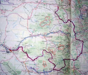
The fundamental plan was to start in Steamboat Springs, take the Great Divide Route then veer west through the mountains to eventually end up in Grand Junction. Of course, doing a point to point bike ride creates the problem of getting to and from your start/finish points, and in this case we were super pleased to have the opportunity to get a ride from the Family Southwick (great friends and former Cycling Utah Commuters of the Month – July 2011 issue), who were headed out to do a backpack in the Rabbit Ears Pass area above Steamboat. And I had remembered that Amtrak has a service from Grand Junction back to Salt Lake via Green River and Price (we had talked about using it as a way to get down to ride in Fruita for a weekend, but had never had) so we bought a ticket and were therefore committed to getting from Steamboat to Grand Junction in a week.
After showing up promptly at the appointed time (for once; good practice for later needing to meet the train!) at the Southwick’s we loaded us, our bikes, the Southwick kids, their camping gear, and Andy and Megan into Andy’s beloved Vanagon and started chugging our way eastward. An uneventful drive ended with them dropping us off alongside the road a few miles up the pass from Steamboat late that night, and as the Vanagon trundled off into the darkness we hoped that we had grabbed everything out of it!
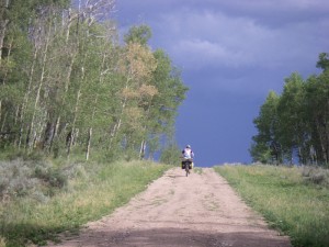
The next morning we awoke to voices, which was a bit surprising given that we were a few miles outside of town, but it was some cyclists working their way up the pass, that became some more, and then a veritable crowd. I couldn’t believe it; was it coming full circle to me and the Ride the Rockies was coming past me again, right at the beginning of my tour, after all these years? But it turns out that we had stumbled into the annual Tour de Steamboat, a century-plus ride that goes over a couple of nice passes in the area.
From downtown Steamboat we easily found our way onto the Great Divide Route (GDR) and quickly left virtually all traffic behind as we wound our way into the mountains on one-lane gravel roads. The route rambled and rolled with no major climbs but plenty of staircasey stuff to culminate in a final 10 mile plunge — described as one of the best descents on the GDR — down to the Colorado river near the famous Gore Canyon and Pumphouse whitewater sections of the Colorado.
The new morning provided a bit of a surprise: I went down to the little creek that we camped alongside to get some water for tea, came back up to our camp, and asked Ash “why is your handlebar bag in the middle of the creek?” Sure enough, although she had put the bag in the vestibule of the tent to keep it out of the gratuitous CO thunderstorm, somehow over the course of the night some varmint – we think – hauled it down to the creek to check its contents, which were now downstream. Fortunately Colorado’s 2012 drought meant that there was very little water in the creek and everything – including her wallet – was recovered, including a couple of soggy bagels bobbing merrily in an eddy! (Why said varmint didn’t actually eat the bagels, and for that matter took the thing to the creek in the first place….we’ll never know).
Butte and Aspen.
From the river we climbed up and over a smallish pass and cruised into Kremmling – an unlikely home of mountain bike nationals for two years prior to it moving to Sun Valley – and then into some high plains. Our progress was momentarily halted as we cruised into a thunderstorm complete with ground lightning less than a mile away, but a scrabbly farm provided a bit of shelter until it passed. A climb up our first “big” pass – Ute Pass, at 9500’ – followed, and en route we passed first a national forest sign with its requisite eco-friendly look and verbiage, and then a full-on wasteland of an enormous hillside-decimating, toxic waste sludge pond-infested mine halfway up the pass. The National Forests…protecting our watersheds. Check.
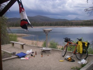
Carrying on, we ended up in the outlet mall paradise of Dillon and after a bike-path climb of the Dillon Dam we found an awesome campsite just off the same bike path a half mile from a campground. This was notable because due to the severe Colorado drought the reservoir was quite low, so the “lakeside” campground had become a long mudflat-side campground, but at least it was expensive and stuffed with RV’s, so the ability to find an adjacent spot that actually was lakeside and super quiet was another great example of the elegant simplicity and flexibility that bike touring enables.
The next day we proceeded up the bike path to Breckenridge, and again veered off the main highway to climb beautiful Boreas Pass, which though over 11,000 feet was first done as a train route back in the day and the resultant gradual grade – on a gravel road – made it feel quite cruisey. After plunging down Boreas we found ourselves out on some of Colorado’s high plains with the mountains fading into the distance and a long, desolate section of mostly nice – but some washboardy – gravel roads taking us
straight south. At the little hardscrabble hamlet of Hartsel – recommended as a camping spot on the GDR map – we found ourselves with 75 miles under our belt in the middle of the afternoon with plenty of daylight left. As we were debating what to do I went into the gratuitous small town seedy bar to get some water. I was told that the tap water there “wasn’t really that good” – by a guy who had clearly drank too much of it, but didn’t want to elaborate – we elected to throw down another 30 miles or so to veer off the GDR and take the highway to end up in Buena Vista, which proved to be a wise choice, despite a minor soaking by a short-lived thunderstorm.
Buena Vista is a great little town supported in large part by the huge rafting business there on the Arkansas and tourists hiking the big passes through the Collegiate range. Figuring that we couldn’t be right there without giving at least one of the much-vaunted Colorado Fourteeners a go, we decided to do a “rike” (ride-hike – see the August 2009 Cycling Utah) up Mt. Princeton, the massif that looms right above town. So leaving our camping gear to collect later and only toting our running shoes we rode the 10 miles of increasingly-steep grade up into the mountains and finally – when we realized we weren’t riding any faster than we’d be walking – ditched the bikes (throwing our shorts chamois-side out over the frame as a theft-deterrent; a long-time technique employed by experienced Rikers) and started marching. We didn’t quite make the summit due to thunderstorm concern, but had a nice hike up and down, then a fun cruise back into Buena Vista, where we retrieved our gear and headed up Cottonwood pass; the route that goes straight up into the Collegiates and over into the Taylor River/Crested Butte area.
We camped near the trailhead for Mount Yale in order to give us the opportunity for an earlier start to get up and down before the daily thunderstorms, and that worked out well. I noted that the climb was comparable in elevation gain and distance to our local Pfeifferhorn, but realized that starting that high means that it does take a bit longer. However, being in running shoes without backpacks and therefore the inability to carry much meant that going light meant going a lot faster than our waffle-stomper wearin’, big pack with ten – or 20? – essentials – totin’ fellow hikers. And even midweek there were a lot of them. Coloradans – and tourists – love them Fourteeners. But we were right there with them and of course the view from the top was great.
Back down at our steeds a guy we had passed earlier asked us how long our round trip took, and our answer of “we’re not sure” was clearly perceived as a lie/affront; he was certain that we were holding out on him, and clearly how fast we went was far more important to him than to us. Ah well, we all have different reasons for tromping around the mountains.
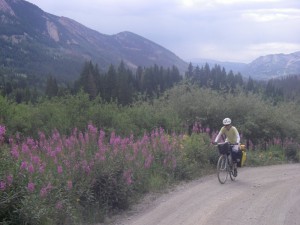
That day was a good one for vertical; after summiting Mount Yale we then rode over Cottonwood, which was going to be crossed shortly after in a stage of the Tour Of Colorado (which Jens Voigt won in an epic solo effort). Like many Colorado passes, it’s a long, but not too-step grind through mostly open woods to a few switchbacks above treeline to top out well over 12,000 feet. The east side is paved, and the west side is fast easy dirt (the Tour of CO climbed the dirt side from the West). We descended to Taylor Reservoir, a huge ATV enclave where hundreds of the local motorheads were going to undoubtedly look at the spindly lycra clad racer boys with as much disdain and curiousity as they did to us dundering along with our loaded bikes.
Cumberland Pass goes from kinda nowhere – aforementioned Taylor reservoir – to nowhere – 15 miles east of Gunnison, so it’s nearly devoid of traffic and is another great pass. It seems like the old mining industry of Colorado meant that they made a lot of small roads going up and over the mountains, which makes for great bike touring. And upon arrival in Gunnison we realized that a better way to get to Crested Butte was to go over Ohio Pass: another virtually car-free, dirt-road climb up to about 10 or 11k through one of the biggest aspen groves on earth and a seven-mile downhill cruise into Crested Butte, one of the truly-cool and relatively unspoiled mountain towns in the West.
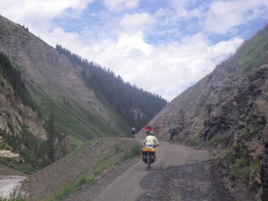
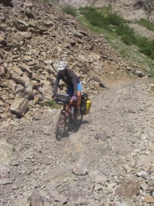
Some years ago Ashley had ridden Schofield Pass up from the north side – above Carbondale – and over to Crested Butte and back in a day on a mountain bike, and she remembered it as being pretty burly. Our initial thought was that we might take the Pearl Pass route to Aspen instead, but we were a little concerned that might put us a bit behind schedule to make our train and there was some question about the possibly-higher level of burliness of that route. So up from CB to Schofield we went, where Ash identified an awesome 8 mile hike up to West Maroon pass, which provides an incredible view of the West Elks, the mountains that some Boulder-based friends feel are the best in Colorado. There is a ton of relief there, and in the next 10 miles we plunged over 4000 feet down into the Crystal drainage on a pretty full-on 4WD road, complete with 20% grades and both embedded and loose baby-head rocks. It was challenging and time consuming on our loaded, rigid bikes, but was super cool. We ended in the little hamlet of Marble – made famous, not surprisingly, for its striking marble that has been mined for a gazillion years, some of which is in the Salt Lake City LDS temple – where we ended up on the porch of the Beaver Pond Inn, which is normally booked months in advance but had a cancellation for that night. As we pondered our options (it was pretty expensive) the classic Rocky thunderheads opened up yet again and made our choice quite apparent. And the news that the only restaurant in town was a Deadhead-run barbeque sporting Colorado microbrews on tap definitely sweetened the deal!
Marble marked the end of the babyhead-fest, and a nice cruise down to the base of McClure pass – signifying the break between the Rockies and the ‘West Slope” – made for yet another climb and a long buzz down towards the cool town of Paonia. Once in town we found out about a place that was sort of a turbocharged fruit stand complete with a café, music, their own cider, and local fare, so we were able to mow into an succulent meal of locally-sourced meat, slow fire-roasted peppers (done by an old employee of a Salt Lake City’s Liberty Heights Fresh), local cheese, etc. We got some beta from locals to utilize great roads winding up towards the Grand Mesa (the huge mesa that separates the Gunnison and Colorado River Valleys; very similar to the Manti-LaSal Skyline), and we ended our day at a campground that was just welcoming a 600-strong crowd of sober “bikers” (of the throttle kind)!
By now it was Saturday night and our train was leaving Grand Junction at 4 pm the next day, so as we pored over the maps (and our daily Colorado microbrews) we were concerned that we might have a hard time making the 80 miles up and over the Grand Mesa and back to GJ by the time we needed to be at the train station to box up our bikes. The climb up the Grand Mesa was apparently 17 miles and topped out over 10k feet, and as much as we had our climbing legs well tuned by this point we decided it would be prudent to expedite our journey. Our campground host turned out to be former pro triathlete turned biker-cum-campground host, and pretty much couldn’t wait to haul us and our steeds up onto the mesa. So in the morning we took her up on her generous offer and watched the climb zip by from the windows of her truck. What we didn’t realize is that the southern side of the “mesa” is more of a peak, and once back on our bikes we basically coasted almost 25 miles down to I-70, where it was only 20-odd miles to the Junction. So we had tons of time after all.
On the way was Palisade, which is the peach capital of Colorado, and the harvest was in full swing, of which we partook at one of the many farm stands. Some fellow Sunday cyclists gave us the beta of the scenic route into Grand Junction, so we climbed up onto a low mesa that was nearly car free with the aroma of ripened peaches in the air. We rattled leisurely along that mesa until we saw central Grand Junction looming below, and a final descent brought us into their nice downtown and the train station.
Riding the train back was both great and a bit frustrating; we hadn’t been on a domestic train since we had been in France a couple of years prior, and we were as disillusioned with “our” trains as we had been amazed at the French trains. Super-confusing seat/car arrangements that had literally ALL of the customers bumbling from one car to another asking the same questions of a tiny handful of officials, the meal service situation was painfully obtuse (but at least they kept calling out names over the intercom well into the night as we tried to sleep) and even barely-perceptible grades slowed our blue bullet to a crawl. But the fact that they only charged us $5 extra for the bikes and had boxes at the station for us to use was slight mollification. And it was a very comfy and relaxing way to wind our way home.
We rolled into the Salt Lake City train station around midnight; quickly put the bikes back together, and wobbled back into Sugarhouse, weary and happy. Our journey through Colorado – many years in the coming – had proved to be some most-excellent riding indeed.