By John Roberson
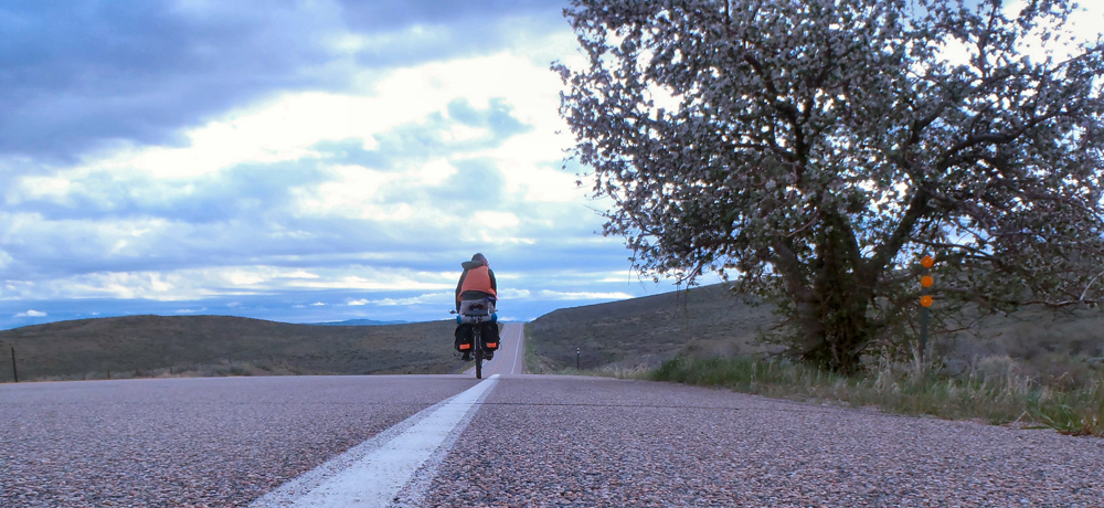
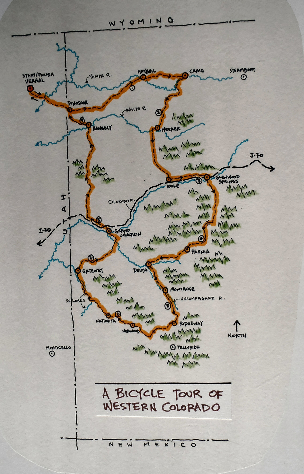
The following is a description of a mid-May bicycle trip that I took through parts of the western third of Colorado. I traveled solo for 10 days, and I was completely self-supported. I rode an old-school mountain bike with 26 inch rims, made by Rivendell Bicycle Works, and it performed beautifully. I started and finished my trip in Vernal, Utah. It was a wonderful trip!
Day 1
The weather was lovely as I rode east from Vernal that first morning. The rains of the previous day had given way to calm, fragrant air and beautiful, partly cloudy skies. I put in the first few miles getting accustomed to my load while also considering my options for the next week or so. I was excited to explore some new byways and revisit a few places I’d passed through on previous trips, to see how things might have changed. I’d camp out under the stars, climb and descend a few passes, and experience a variety of terrain. I was sure it would be lots of fun!
The highway miles from Vernal to the Colorado line were easy. I had grand views of distant red rock cliffs, a very nice shoulder to ride on, and a sweet tailwind to help me along. I crossed the Green River at Jensen, Utah and climbed up and out of the river bottoms. I stopped at the Musket Shot Springs historical site east of Jensen, to stretch my legs and to marvel at the spunk of those two old travelers, Dominguez and Escalante. I paused again at the Colorado state line.
I spent about 45 minutes in Dinosaur, Colorado, taking an very nice break at the Conoco station. I bought some juice and a popsicle, and I sat in the shade for a while before continuing east on U.S. 40. I rode all afternoon, pushed along by a light tailwind and encouraged by the quiet roads, which made it easier for me to relax and enjoy the sights. By late afternoon the sun had given up and gray clouds were filling the skies. Wet weather was still a few hours off, but I’d be sure to pitch a shelter when I stopped to camp.
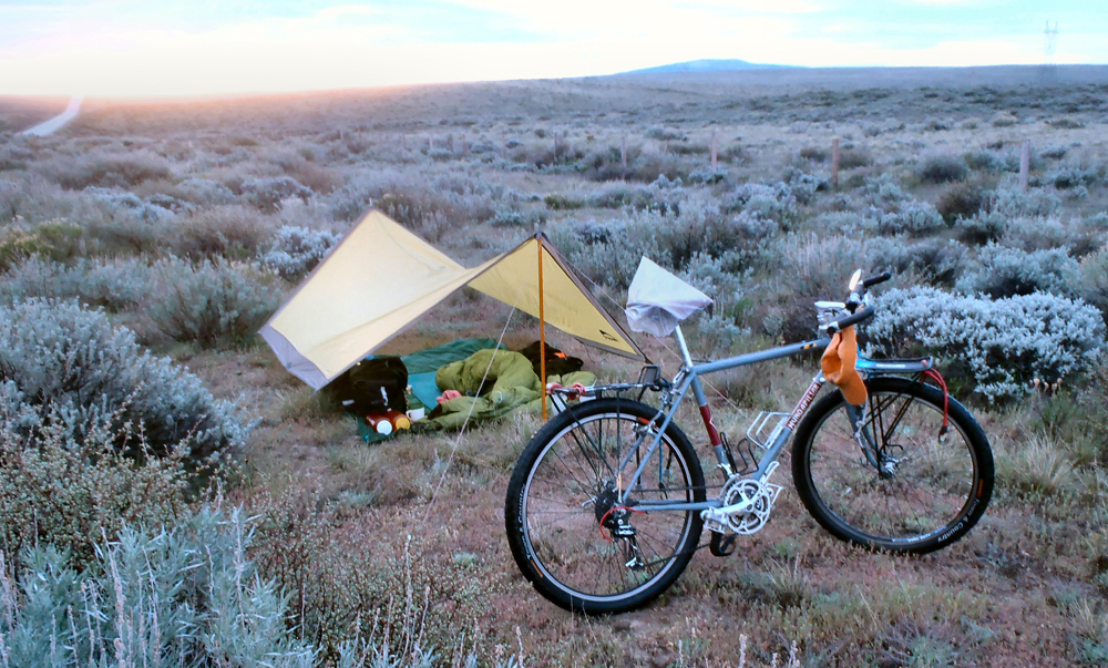
As the afternoon light started to fade I found a wonderful little campsite in a sagebrush meadow off the side of the roadway. I pitched the shelter, set up my camp and settled comfortably into the first evening of the trip. I got the evening’s meal going, had a little toddy, made a few notes and admired my surroundings. Darkness eventually settled in, and with the smell of rain in the breezes, I hunkered down for the night.
Day 2
Clouds still filled the skies when I woke before first light the next morning. It had rained during the night, but I had been dry and comfortable under the shelter, and I slept well. I went through my morning chores and was encouraged by the appearance of a wide band of sunlight at the eastern horizon. It looked like it was going to be a beautiful day.
I left camp and headed east into morning sunshine. I ran into a fellow bicycle tourist in the small town of Maybell, Colorado, which sat a few miles east of my campsite. He rolled up as I sipped a second cup of coffee at the general store. He was riding west from Boston and had spent the night in the wayside park adjacent to the store (a good overnight rest area!). He didn’t say much, but he did inform me that Maybell holds the Colorado record for the lowest recorded temperature … a minus 61!
I left Maybell heading east again along the Yampa River, then climbed out of the river bottom proper and onto a series of benches, toward Craig, Colorado. The riding was nearly effortless. A light tailwind continued to help me along, and the wide shoulder and gentle hills of the benches made it easy to put in the miles. Unfortunately, I had a blowout along the way and had to make repairs before I could carry on. It surprised me. I had thought to change tires before I left home, but decided I could get one more trip out of the old ones. It was a decision I would come to regret more than once during the trip ahead.
I made Craig in the early afternoon. I picked up a couple of new tubes at the ranch store, and was eating a six-inch tuna at the Subway when a fierce little rainstorm came through town. Good timing, I guess. The storm threw down a good amount of water in a short period of time, but the sun came back out bright and strong shortly thereafter.
I left U.S. 40 at Craig and began riding south on Route 13. I followed the Yampa River for a few miles, then broke off to follow a tributary called William’s Fork. I left that creek for a smaller one that I followed for the rest of the riding day. The road was peaceful and quite scenic as it followed the creek bed, climbing slowly and gently to the south. Around dusk I found decent campsite on a hillside above the road, at the mouth of a small side canyon, and settled in for another restful night.
Day 3
I awoke to frost on my gear and temps in the high 20s. It had been a chilly night, but I had slept well. The rising sun took its sweet time getting to my camp, but once it arrived things warmed up nicely. I broke camp, loaded up, and hit the road for the fourth day.
I continued my climb to the south, out of the Yampa River watershed and into the upper drainages of the White River. I crested the “gap” at about 7500′ and enjoyed an easy cruise down the other side into the town of Meeker, Colorado.
Meeker was a lovely town located on the north side of the White River. It sat a few miles upriver from the site of the infamous Meeker Massacre where, in 1879, nearly a dozen Indian agency workers were killed by disgruntled Utes. It was a tragic event and had the result of consigning all of the free-roaming Ute tribes in the region to reservations in Utah. A tragedy for everyone, really. I rolled into town mid-morning and bought a couple of excellent pastries in a shop on the town square. I sat in the shade of the square, enjoying my pastries, and wrote a postcard to my old Auntie. I gave my sweetie a call, too.
I left Meeker and the verdant farms and ranch lands along the river and began climbing again to the south, up and over the White River’s watershed and into the drainages of the Colorado River. I was still on Route 13, and I spent the next few hours slowly working my way along straight roads that passed through arid badlands and barren ridge tops. To me it was very pretty country. I fixed another flat at one point in the mid-afternoon, then rolled past bluffs and hogbacks to the east and the Roan Cliffs to the southwest.
I took a welcome break when got to the town of Rifle, with both I-70 and the Colorado River flowing in their own unique ways nearby, then meandered another 10 to 15 miles east on two-lane roads that ran parallel to both the freeway and the river. As I rode into the early evening hours the roads began to peter out, and I noticed a narrowing-down of the valley ahead into a canyon through which both the river and the freeway were being squeezed. It didn’t look so good. A perky couple jogging along the frontage road warned about dead-ends ahead and the unavoidable need to hit the freeway for a while. So off I went.
I put in a couple of stressful miles heading east on the freeway, then took a river access exit that put me across the river from the freeway. I found a surprisingly decent campsite with lots of flowers and birdsong, on the hillside above the river, and away from the worst of the highway racket. Given my camp’s proximity to the freeway, the river and a set of railroad tracks, I wouldn’t have expected to sleep as well as I did.
Day 4
I left my riverside camp the next morning and took a slight detour to check out a bike path that paralleled the freeway heading upriver. I’d seen it the evening before, but wasn’t overly optimistic about it. Sure enough, it dead-ended a half mile up the canyon. However, it did look a bit like a work in progress, so it might be worth a try the next time I pass through. Anything would have been an improvement over the few busy freeway miles I had to endure to get to Glenwood Springs.
I took the exit into Glenwood Springs and was immediately impressed. The modestly sized town at the confluence of the Roaring Fork and Colorado rivers had a great vibe and I quickly felt at home. No one seemed to be in any particular hurry as the work day began, and the town’s many trees and blooming flowers made that particular May morning especially nice.
Glenwood Springs began in the 1880’s as a rough-and-tumble center of regional commerce, and many attractive, older buildings remain in the town’s business district. It grew in importance over the years with mining interests, the railroad, and the development of the thermal springs all drawing settlers to the area. Various famous characters came through, too, including Teddy Roosevelt, who spent a summer there. The town is criss-crossed with bike paths and pedestrian walkways and is a popular destination for folks living in Denver, or so I was told. I could see why it would be.
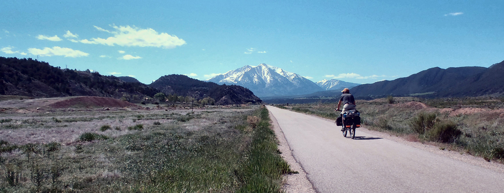
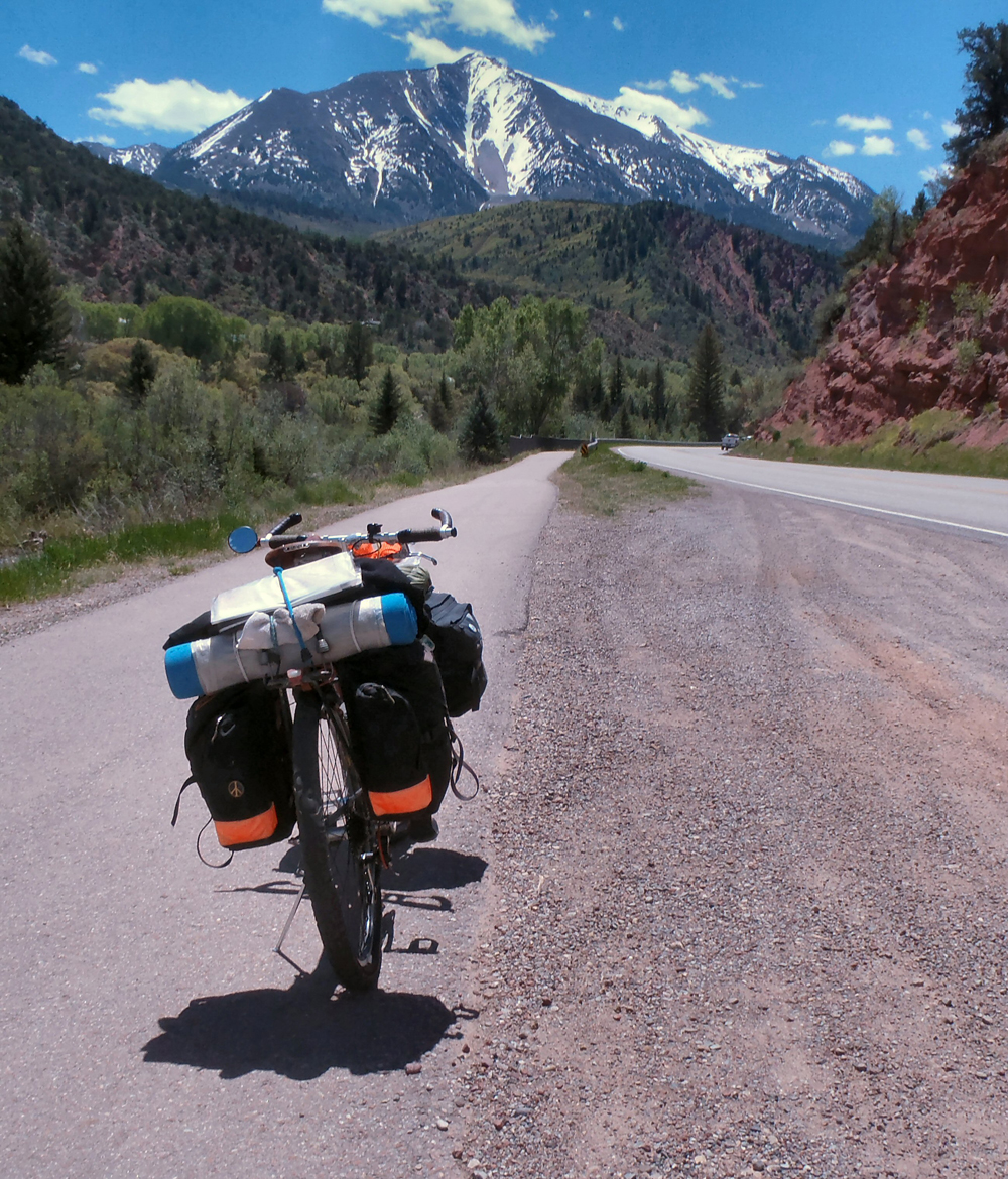
I cruised the downtown streets for a while, then connected with an excellent bike path that ran along the eastern edges of the Roaring Fork River. I had been told that the path would keep me off the busy, four-lane highway and take me upstream for more than 15 miles, through Carbondale and beyond. After the hubbub of the freeway it seemed the obvious way to go. So I took advantage of the path and the beautiful weather to pedal the pathway upriver, beyond the busy turnoff to Aspen, past Carbondale and into the canyon formed by the Crystal River, a tributary of the Roaring Fork. In the distance, to the south and east, I began to see the first of many glorious, snow-capped Colorado peaks.
I lost the bicycle pathway at the Crystal River Resort, then spent the next few hours working my way up the river, passing through the charming community of Redstone and really picking up elevation in the process. The roads were quiet and smooth, but the wide shoulders I’d been enjoying the past few days seemed to have petered out there in the canyon. The road became steeper as the afternoon wore on, and I ground my way up and over McClure Pass (8763′) late in the afternoon, my first serious pass of the trip. I spent what was left of the day dropping down the other side of the pass and into the drainage of Muddy Creek. I found a high, open campsite off the road and above Paonia Reservoir and settled into yet another comfortable evening routine.
Day 5
I woke to temperatures in the upper 20s, but the sun warmed things up quickly, and I was heading down the canyon below the reservoir by 8:00 a.m. I was once again leaving the cooler high country behind me and dropping into the wider and warmer floodplains of the Gunnison and Uncompaghre Rivers, to the west. I stopped for a second, delicious creek-side breakfast at a cafe in the small town of Paonia (named, it seems, for a shortened version of the Latin name for the peony roots first brought to the area by one of the town’s original settlers), then carried on.
By mid-morning I was back in the low country again and heading west, through Hotchkiss and on to Delta, Colorado. The day was beautiful, but it had warmed considerably, and the roads had become pretty busy as I passed through Delta around mid-day. From Delta I picked up route 50 heading south towards Montrose and into the Uncompaghre River Valley. At this point I was back in civilization again and forced to deal with a lot of traffic flowing between Grand Junction to the north and Montrose to the south. I managed to find frontage-type roads here and there that allowed me to leave U.S. 50 occasionally, but they weren’t consistent. Although the day’s weather was perfect, and the surrounding agricultural lands lush and green, the constant roar of the highway made this stretch of my tour less than ideal. I spent the afternoon working my way up the river valley, arriving in Montrose at the end of the valley’s working day. I took a nice break in town to cool my heels and let everyone get home for supper, then carried on riding south.
The evening traffic was noticeably quieter as I left the wider river valley behind and continued my gentle climb upriver on U.S. 550 toward more beautiful, Colorado high country. As the sun settled lower in the west I realized that the country I was riding through was still fairly densely populated. Finding a decent roadside camp would be tough, so I bit the bullet and pulled into the Centennial RV Park, paid 26 bucks to a very nice lady, and set out my camp on a sweet piece of lawn away from a small cluster of big rigs in the more developed portions of the park. It was a wonderful, peaceful campsite and I slept like a log.
Day 6
I was up early the next morning and back on the road feeling rested and ready for what looked to be another beautiful day. The sky was clear and bright, the meadows were filled with spring flowers, and the southern horizons ahead were filled with the awe-inspiring, snow-capped peaks of the San Juan Mountains … serious mountains, for sure! I knew I’d be interacting with them during the days ahead, but I wasn’t overly concerned. After all, I’d be skirting the very highest regions of the mountains, and I knew that both my lowest gears and plenty of time would eventually get me to the top of any minor pass I encountered along the way.
After about an hour of easy morning pedaling through pinion and juniper country, I passed a large body of water called Ridgeway Reservoir, and an adjoining state park of the same name. Just beyond the park I came across an access to a developed bicycle/pedestrian path that led me along the river for several easy miles, all the way to the lovely town of Ridgeway, Colorado. The town sits with grand views of the surrounding peaks and is referred to as the Gateway to the San Juans. It’s a popular stop for travelers heading to Telluride and other points south. I took a nice break in town, then began what looked to be a long haul up the hill to the high pass beyond.
The climb from Ridgeway to Dallas Pass (about 9000′) was tough, and it took me a few hours to reach the summit. I stopped frequently to admire the views and, on one occasion, to shoot the breeze with a friendly Colorado trooper. The ride down off the pass on the other side was an easy cruise, and I hit the red rock canyon of the San Miguel River (a tributary of the Dolores River) in the later afternoon. I took a sit-down break at the general store in Placerville, a very small community a mile or so upriver. I chatted with a couple of motorcycle dudes who had trailer-ed their bikes from Denver to cruise the deliciously curvy canyons common to this part of the state. Nice guys, and just two of dozens of bikers who passed me during the next the next day or so.
From Placerville I headed back down river and fairly flew along. At one point the road left the San Miguel riverbed proper and made a short climb up and over into the drainage of two minor creeks that feed back into the San Miguel, further downriver. I had left the busy roads behind me and was, once again, back riding through quiet, ranching and agricultural lands. I rode through the small farming/ranching town or Norwood in the early evening. The town was quiet and had clearly shut down for the day, but I spent a pleasant 15 minutes there, by the side of the road, sharing stories and advice with an amiable fellow named Phil, who operated a surprisingly well-equipped bike shop there on the main street of town.
After another hour of riding through a mix of pasture and juniper scrub land, the sun dropped below the horizon, and I found myself scrambling into the scrub by the side of the road and into my sixth cozy camp of the trip.
Day 7
The sounds of early-morning traffic woke me from another excellent night’s sleep. After going through my morning routine I was back on the road and looking forward to another flawless May morning. I paused in the town of Naturita where I had a second breakfast and considered my situation. I had pretty much reached the southern-most point of my trip and would need to head back north in order to complete my trip loop. I knew from an earlier trip that I couldn’t count on much in the way of amenities between Naturita and Grand Junction, which I hoped to reach at the end of the following day, so I picked up a few necessities in town and headed back down the road.
The next thirty miles or so were something of a dream. The quiet, two-lane road followed the San Miguel River, and then the Dolores River, through shallow, red rock canyons filled with cottonwoods and flowering shrubs along the river banks. The well-surfaced road twisted and turned constantly, following the bends in the river flow … a treat for me and for the occasional groups of touring motorcyclists that passed me by.
I eventually came to the tiny community of Gateway, near the Utah border, where I took an extended break at the general store. Gateway is the home to a rather swanky resort that reportedly serves as a base for many outdoor activities, and I caught glimpses of it in the distance as I rode into town.
I left Gateway’s shade in the middle of the afternoon, heading north again, and spent the rest of my easy day slowly gaining back some of the elevation I’d lost. The nearly empty road climbed gently along a small creek in a shallow canyon that eventually opened up into a high, wide, green valley. There were meadows and pastures, and modest farms and ranchettes on both sides of the road. As the sun neared the crests of the western hills I realized that I had probably reached the highest and coolest parts of the drainage (a good place for sleeping!), so I searched out and found another roadside camp zone, and settled in for what would be still another restful night’s rest.
Day 8
I began another flawless Colorado morning with an unexpected stop just a mile down the road … my third flat of the trip. I made my repairs and was up and moving again fairly quickly. After a very few miles, I crossed the Unaweep Divide and began dropping northeast into Unaweep Canyon, beyond. The riding conditions were excellent. I was once again leaving cooler, higher, and greener plateau regions to re-enter arid landscapes that characterize much of both the western parts of Colorado and the eastern parts of Utah. As I rode I could see, in the distance, the green ribbon of the Gunnison River in dramatic contrast with the dry zones between and beyond.
I reached U.S. 50 around midday and jumped right into the steady traffic flowing between Delta and Montrose, to the south, and Grand Junction to the north. Grand Junction was a dozen miles further down the road, where the Gunnison River joins the Colorado River (the “junction” in Grand Junction). I was hoping to find a new tire and tube and a hearty meal before continuing north and back into quieter country.
Grand Junction was certainly the biggest city of the trip. With over 140,000 people living there I was sure to find all that I needed, and then some, but I was surprised and delighted to find that on that day the downtown district had been taken over by bicycles! It seems the Grand Junction Off-Road Mountain Bike Event was in full swing, with races and events and music occurring over multiple days, and cyclists had come from all over to enjoy the festivities. The downtown streets had been closed to traffic and were lined with vendors and manufacturer’s reps selling anything and everything related to two wheels. I had no trouble finding a replacement tire and tube, and I spent a very leisurely couple-of-hours making my repairs in the shade of a small city park. Some nice young fellows from Denver kept me company as I worked, and we shared stories about our recent two-wheeled adventures.
I loaded back up again, bid adieu to my Denver friends, and headed out into the neighborhoods north of town. I was searching for a route to the northeast, and I eventually ended up near Interstate 70, which passes along the northern edges of Grand Junction. I meandered along the frontage roads near the freeway all the way to the community of Fruita, where I stopped for a hearty meal and a cozy bed. I checked into the very comfortable, Balanced Rock Motel for a much-needed shower and good night’s sleep.
Day 9
The following morning I was up and out and on the road earlier than usual. I was heading north again, aiming for the small town of Rangely, and I knew I had a substantial climb ahead of me. But, the restful sleep I’d had, as well as my early start and another beautiful May day left me feeling optimistic about the road ahead. I left the frontage road and the sounds of the now-distant freeway in Loma, Colorado, and started up Highway 139.
The riding was pleasant that morning as I climbed gently, but steadily, out of the meadows and green fields of the Grand Valley. Mountains and ridges filled the northern horizon in front of me, but they didn’t seem so bad, compared to the snow-capped peaks I’d left behind. The wide valley narrowed as I climbed, and by late morning I found myself in a tight canyon following a modest creek. The road had been very quiet all morning and would remain so for most of the day, but it became steeper as climbed toward Douglas Pass, the high point for the day. The high canyon opened near the summit ridge, and I found myself switch-backing slowly through scattered conifer forests and mountain meadows. I reached the pass in the middle of the afternoon and paused to rest and check out the scenery. Far away to the south I could just make out the hazy green of the Grand and Gunnison Valleys and the snow-capped San Juans much further to the south.
I eventually dropped off the pass and onto the greener, north-side slopes of the ridge where I wound my way through lush, flowering meadows and groves of aspen along West Douglas Creek. I took my time as I descended, keeping my downhill speeds low so I could relish the high country sights while I could. The blue skies of the morning had, by this time, given way to dark clouds to the north, and I suspected I might experience rain for the first time since my first night on the road. I dawdled quite a bit, stopping often to let nasty-looking pulses of wet weather pass by in the distance. I stayed dry, but the highway itself was wet along several stretches. The canyon widened, and as I approached the mouth of the drainage I relished the classic, high-desert smells of sage and springtime that are especially fragrant after a rain.
I arrived in Rangely and passed through the peaceful town as the sun was settling onto a wide open western horizon. I crossed the White River on the east edge of town, climbed up and out of the river bottom, found a very reasonable campsite off in the sage north of the highway, and settled in for my last night on the road.
Day 10
The last day of my ride was delightful. It would be a short day, so I dawdled a bit over my breakfast before loading up the bike for the last time and heading back up the road. The morning traffic was light and seemed to be made up of oil and gas field service vehicles heading out for the day’s chores. I rolled along easily, enjoying both the wide-open scenery and the fine roadway. I passed through Dinosaur again, took another break at the Conoco station, then crossed the state line back into Utah. After a couple of hours of effortless riding (with still more accommodating tailwinds!) I arrived back in Vernal. After loading up and once again thanking the motel owner for keeping an eye on my truck, I headed west for home, another successful and memorable tour under my belt.
Note:
Western Colorado highways are generally excellent, though they do tend to go up and down a lot. The road surfaces are smooth, and wide shoulders are more common than not. Colorado drivers seem to be courteous and bicycle-conscious. I was never very far away from food sources, or water sources. Roadside historical sites were common, as were roadside trash cans. Roadside fences made finding off-road campsites more difficult to find than in my home state of Utah, but there was always some sort of off-the-road, out-of-sight option for me. The people of Colorado were extremely friendly, all of the time, and they made me feel very welcome.