The Bridger Valley Historic Byways Ride is a 49.7-mile route in Wyoming’s Bridger Valley, including an extension to Bigelow Bench. The layout is that of a figure eight with a tail. The figure eight is 25.2 miles in length, while the tail adds on 24.5 miles. One could do the loop, without the tail – but why would you do that? Completing the entire route is highly recommended. The minimum elevation is 6,537 feet, while the maximum is a gasping 7,461 feet, so be prepared for some heavy, high-altitude breathing. This is a great summer ride; be sure to check the weather and road conditions during other times of the year.
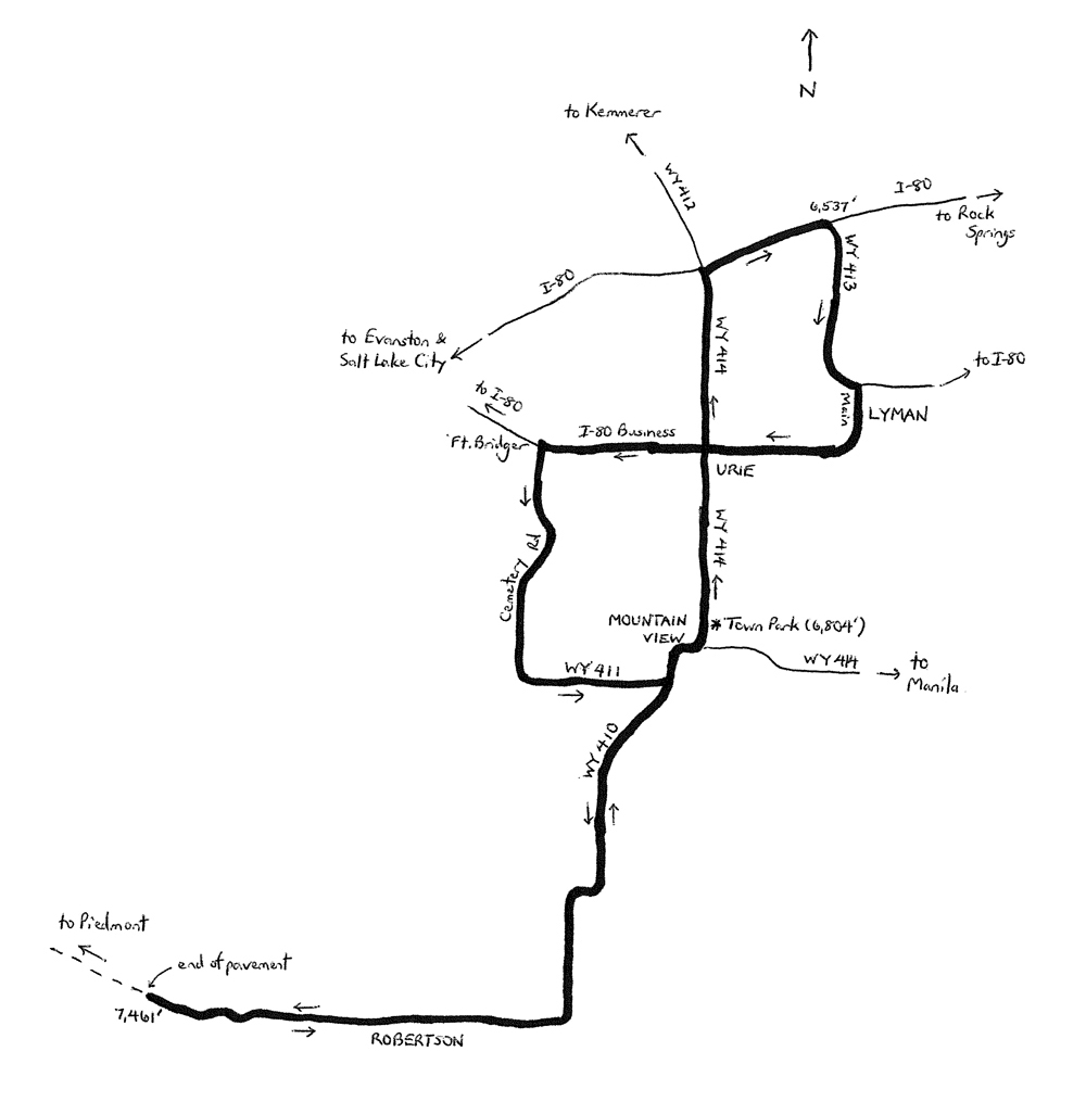
Start the ride at Town Park in Mountain View, located at 405 North Wyoming State Highway 414 (WY 414). Mountain View is located to the south of I-80, along WY 414, 122 miles east northeast of Salt Lake City. The ride starts here, in the town of Mountain View, and visits the town of Lyman, and the communities of Urie, Fort Bridger, and Robertson, all in Bridger Valley. A total population of just over 4,000 resides in the valley. While this is small by today’s standards, the valley was a hubbub of activity in the mid-19th century. After the legendary “mountain men” began to rendezvous in the region, starting in the 1820s, Fort Bridger was established as a fur trading outpost in 1842. Later, the fort became a critical supply center along the California, Mormon and Oregon Trails, all of which passed through the area. By the late 1850s, hostilities between Mormon pioneers and the U.S. government had escalated, and the outpost was converted into a military fort. By the 1860s, the fort was also serving as a stop along the Pony Express. Yet, when the Transcontinental Railroad was completed in 1869, thereby relegating the Pony Express and wagon trains to extinction, the fort’s role diminished. Military positions had shifted elsewhere by then, to Camp Lloyd and Fort Douglas near and in Salt Lake City. Fort Bridger was shut down in 1890. Historical sites in the valley are limited to Fort Bridger, and an old bridge across Black’s Fork. The real history, though, is in retracing the routes of the travelers who passed along those trails.
From Town Park, turn right and head north on WY 414. The starting elevation is 6,804 feet, and the highway is effectively downhill as you head north. Enter the community of Urie at mile 3.0, and keep right on through, all the way to I-80. The I-80 freeway? Yes – there are not enough roads in this area to avoid a short stretch on the shoulder of the freeway. The freeway was carrying 16,480 vehicles per day in 2016, though, which is very light by Interstate standards. Cross over Black’s Fork at mile 7.75. At mile 8.1, turn right and enter I-80. Stay to the far right, on the shoulder. Take the next exit (Lyman). At the end of the off-ramp, turn right and head south on WY 413. This is the lowest elevation of the entire ride (6,537 feet; mile 10.2). From here, the highway climbs gradually, and then steeply (8.2% grade) to enter Lyman. With over 2,000 residents, Lyman is the largest town along the ride. Follow WY 413 as it climbs and curves to the left. At the end of WY 413 (elevation 6,714 feet; mile 13.0), turn right onto Main Street. Main takes you through the heart of town. Beyond Lyman, Main curves to the right, becoming “Business I-80.” You are on the Bridger Valley Historic Byway, retracing the route that many pioneers took, long before I-80 was built. Return to Urie at mile 16.1. Keep straight through once again, heading west toward Fort Bridger. Once there, turn left onto Cemetery Road (mile 18.6), just in advance of Fort Bridger. In fact, a slight detour to the fort would be in order, as part of your historical journey!
Once back on Cemetery, head south. It is a steady climb to WY 411 (elevation 6,963 feet; mile 22.4). Turn left here, to head east on WY 411. Now you are descending, heading in Mountain View’s direction. At the end of WY 411, to continue the ride, turn right onto WY 410 and head south. (The alternative is to return to Mountain View). You are now at mile 24.0 (elevation 6,855 feet). The next part of the ride is an out-and-back segment, on WY 410. The outbound ride is a steady climb to Bigelow Bench. The highway heads south, and then turns 90o to head west, taking you through the community of Robertson, and on to the end of pavement (mile 36.25; elevation 7,461 feet). This is the turnaround point. The unpaved road continues to Piedmont, a ghost town that once thrived because of its timber, and its location along the railroad. Save that trip for your mountain bike, perhaps, and begin the return ride to Mountain View. Follow WY 410 as it descends, heading eastward, and then curving to the left to head north. Return to the figure eight loop at mile 48.5, at the intersection with WY 411. Keep straight here, heading toward Mountain View. Follow WY 410 as it turns to the right, to head east, coming to a T-intersection with WY 414. Turn left here to return to Mountain View Town Park, which will be on the right.
Starting & ending point coordinates: 41.272369N 110.336367W
For more rides, see Road Biking Utah (Falcon Guides), written by avid cyclist Wayne Cottrell. Road Biking Utah features descriptions of 40 road bike rides in Utah. The ride lengths range from 14 to 106 miles, and the book’s coverage is statewide: from Wendover to Vernal, and from Bear Lake to St. George to Bluff. Each ride description features information about the suggested start-finish location, length, mileposts, terrain, traffic conditions and, most importantly, sights. The text is rich in detail about each route, including history, folklore, flora, fauna and, of course, scenery.
Wayne Cottrell is a former Utah resident who conducted extensive research while living here – and even after moving – to develop the content for the book.