By Wayne Cottrell — In a recent article, we rode “Four Corners Circle,” passing through four States (Utah, Colorado, New Mexico and Arizona), and visiting the Four Corners Monument. In “Shiprock & Four Corners Roll,” we return to this area, starting in Shiprock, New Mexico, visiting three States instead of four (New Mexico, Arizona and Colorado), and once again visiting the Monument. This route, like the other, is almost entirely within the boundaries of the Navajo Nation (except for the portion in Colorado). Shiprock, the staging city for the ride, is 97% Navajo. The route, at 74.6 miles, is slightly shorter than Four Corners Circle’s 77.2 miles. Be prepared for warm temperatures, possibly in the triple digits, during the summer months.
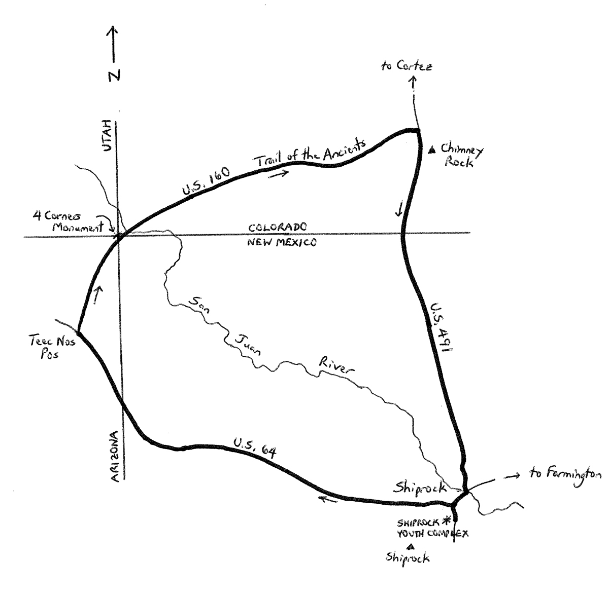
The ride begins in Shiprock, which had a population of 8,295 in 2010, making it the largest settlement within the Navajo Nation. The staging point for the ride is the Shiprock Youth Complex at 4198 U.S. Highway 491, located on the south side of the community. The complex serves as the starting point of the annual Shiprock Marathon, for those of you who also do some running! Exit the complex and turn left, onto U.S. 491. After just under one-half mile, turn left onto U.S. 64 and head west. Leave the comforts of the community behind as you roll past Shiprock High School, on the left, and head out into the open desert. You will notice the faint, reddish tint of the landscape. It is an almost imperceptible climb from Shiprock’s 4,892 feet to Teec Nos Pas’ 5,210 feet, in Arizona, some 26 miles away. Off to the far left, you should be able to see the Shiprock formation, which is a conglomeration of volcanic rock that rises to an altitude of 7,178 feet. The Navajo have named the rock Tsé Bitai, which means “rock with wings,” and consider it be sacred. (Note that, other than isolated formations such as this one, the Four Corners region is comparatively flat). Just before U.S. 64 crosses the Arizona state line, enter the community of Beclabito, which had a population of 314 in 2016. The community had been in the news, most recently, for the local school chef who quit, leaving teachers and bus drivers to prepare the school lunches for the children! Parents were, understandably, outraged. The highway turns northwesterly past Beclabito. Enter Arizona at mile 22.5; enter Teec Nos Pos four miles later.
With a 2010 population of 730, Teec Nos Pos is the last major settlement of the entire ride. Thus, this may be a good place to refresh and stock up for the rest of the ride. Turn right onto U.S. 160 and head northeast. Re-enter New Mexico at mile 31.9. Out here, a visit to Four Corners Monument, which is a Navajo Tribal Park, is worthwhile. As noted previously, this is the only spot in the entire U.S. where four States converge. After one-half mile, turn left onto New Mexico Route 597, which heads directly to the monument. Take some time to visit – described in the “Four Corners Circle” article – and then return to U.S. 160. Turn left and continue heading northeast. Enter Colorado at mile 33.7. Cross the San Juan River, a major tributary of the Colorado River, shortly after entering Colorado. U.S. 160 within Colorado is part of the 480-mile long Trail of the Ancients Scenic Byway. Although there are no specific prehistorical sites along this segment, the reddish hue of the landscape gets deeper as you head east. The canyons and mesas, especially on your right, are a dramatic sight that follow the route for miles.
At mile 51.7, turn right onto U.S. 491 and head south. To your left is Ute Mountain Tribal Park; the park’s most prominent feature, very visible from here, is Chimney Rock. The formation, also referred to as Jackson Butte, has a chimney-like shape – it is also a national monument. Cross the Mancos River, a tributary of the San Juan, a few miles south of Chimney Rock. The majestic Tanner Mesa will be on your left after the river crossing. Enter New Mexico at mile 58.1. After a stretch of open, faint-red desert, a couple of dramatic formations appear on your left and right. The mesa on the left is an outstanding expression of nature’s geometry, as it is almost a perfect trapezoid on top. U.S. 491 reaches the outskirts of Shiprock around mile 72. At mile 73.4, turn right onto U.S. 64, in the heart of town. Highways 64 & 491 actually share this segment. At the next intersection, keep straight to continue heading southward on U.S. 491. From here, it is one-half mile to the Shiprock Youth Complex, which will be on the right. Note that the Shiprock formation is about 13 miles southwest of town.
GPS coordinates of Shiprock Youth Complex: 36.7714oN 108.6991oW
For more rides, see Road Biking Utah (Falcon Guides), written by avid cyclist Wayne Cottrell. Road Biking Utah features descriptions of 40 road bike rides in Utah. The ride lengths range from 14 to 106 miles, and the book’s coverage is statewide: from Wendover to Vernal, and from Bear Lake to St. George to Bluff. Each ride description features information about the suggested start-finish location, length, mileposts, terrain, traffic conditions and, most importantly, sights. The text is rich in detail about each route, including history, folklore, flora, fauna and, of course, scenery.
is this route posted somewhere?