For southern Nevada travelers, Pioche and Lincoln County are promoted as getaway alternatives to the glitter and heat of Las Vegas and Mesquite. While those cities are 150 to 200 miles away from Pioche, Cedar City and St. George, in Utah, are actually closer, at 90 to 110 miles away. Pioche is located along U.S. Highway 93, but it is somewhat out of the way; in fact, some annals claim that U.S. 93 is even quieter than U.S. 50, the latter of which is promoted as the “Loneliest Road in America.” If you can get out here, then you have an opportunity to visit one of the old West’s most notoriously lawless towns. Historians put Pioche in the same class as Bodie and Tombstone, as the roughest, most violent old West towns. The town cemetery, Boot Hill, serves as a memorial to all of the rowdies who died in gun battles.
Things are much tamer today – the heydays of silver mining in the mid-19th century, and manganese, tungsten and lead-zinc mining in the mid-20th century, are long past. The population of Pioche maxed at about 12,000 in the 1870s; today’s population is about 1,000. As one might expect, there is quite a bit of history in town that is worth exploring, such as the “Million Dollar” Courthouse, the Lincoln County Historical Museum, and an aerial tramway (formerly carrying buckets of ore) that is still intact around town. There is also some history at Pioche Town Park, such as some refurbished railroad cars, where the ride starts. The starting elevation is 5,930 feet. So, although Pioche is located at the edge of the Great Basin Desert, the high altitude keeps things cooler than in the cities to the south.
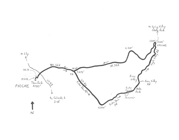
 The Pioche Backcountry Cruise is a 35.35 mile “lollipop”-shaped route that starts and finishes at the town park. The scenery is mostly that of open desert, but there are a few pastoral and canyon segments, giving the ride a pleasant variety. There are no long climbs, and the elevation differential is just under 800 feet (highest elevation reached: 6,018 feet). Part of the ride incorporates the Mount Wilson Backcountry Byway; hence the ride’s name. The annual Park to Park Pedal has featured some of the roads in this ride. From the northeast corner of Pioche Town Park (4th and Mill Streets), head east on 4th Street. Turn right onto Main Street, followed by an immediate left onto State Route (SR) 322. This lightly-used highway heads downhill, crossing US 93 to leave Pioche, and on into Lake Valley. Although this is the Mount Wilson Backcountry Byway, the road goes nowhere near Mount Wilson, which is to the north of here. The highway passes a mill, prison (minimum security), and recreational park on the outskirts of Pioche, before entering open, undeveloped high desert. After gradually descending about 450 feet over four miles, the highway levels. Turn right at Echo Dam Road (SR 86) at mile 4.4, and head southeast. Patterson Wash, usually dry, and an abandoned railroad right-of-way, are to your right. SR 86 curves to the left after five miles, rounding a knoll, to enter Dry Valley. The lowest elevation of the ride is adjacent the knoll, at 5,234 feet.
“Dry” Valley is a misnomer, as the local alfalfa fields are surprisingly green and verdant. The road passes by a few ranch properties as it heads toward Echo Canyon. Enter the canyon at mile 12.4; Echo Canyon Reservoir and an earthen dam are at the canyon’s mouth. This is also the entrance to Echo Canyon State Park, so there is some signing. The next stretch presents a dramatic change in scenery, with 100-foot high canyon walls to your left and right. The white sandstone, eroded pinnacles, and parallel stream are markedly more eye-catching than desert sagebrush! Cross the stream at mile 13.4, and enter pretty Rose Valley. The stretch beyond the canyon is as pastoral as the previous road segment, before you entered the canyon. You are now on Rose Valley Road. At the T-intersection (mile 15.2), turn right onto Eagle Valley Road. The road enters another canyon – not quite as dramatic as Echo Canyon – and then exits to serene Eagle Valley.
After a sharp curve to the left, turn right at mile 19.05 to remain on Eagle Valley Road. Enter the tiny community of Ursine (population 91). This quaint town has a warm presence, and a few tidy, cozy homes. White it seems remote, you have actually taken the back way to get here, as the town is just off of SR 322 (which is where you are headed). There are some provisions in town, in case you are in need. After making a left at the edge of town, turn left again, onto SR 322 (mile 19.85). Note that, to your right, SR 322 continues into Spring Valley State Park (about two miles away) – a side trip may be worthwhile. Otherwise, head west on SR 322. The highway returns to Pioche. The amazing scenery is behind you, unfortunately. A point of interest, though, is that the road makes a steady, gradual climb out of Ursine (elevation 5,562 feet) to the highest elevation of the ride (6,018 feet) at mile 24.0. SR 322 descends from here to Echo Dam Road (SR 86), which you took on the way out. After crossing Patterson Wash (elevation 5,443 feet), it is a steady, 3.8-mile climb back into Pioche. After crossing U.S. 93, turn right onto Main Street, followed by a left turn on 4th, and a left on Mill to return to the town park.
GPS coordinates of Pioche Town Park: 37.936925oN 114.452819oW
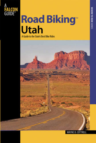
For more rides, see Road Biking Utah (Falcon Guides), written by avid cyclist Wayne Cottrell. Road Biking Utah features descriptions of 40 road bike rides in Utah. The ride lengths range from 14 to 106 miles, and the book’s coverage is statewide: from Wendover to Vernal, and from Bear Lake to St. George to Bluff. Each ride description features information about the suggested start-finish location, length, mileposts, terrain, traffic conditions and, most importantly, sights. The text is rich in detail about each route, including history, folklore, flora, fauna and, of course, scenery.
Wayne Cottrell is a former Utah resident who conducted extensive research while living here – and even after moving – to develop the content for the book.