By Wayne Cottrell
The Oquirrh Mountains Challenge is a 53.2-mile ride that encircles and crosses the Oquirrh Mountain range, passing along the western edge of Salt Lake Valley, and the eastern edge of Tooele Valley. Note that this route is not to be confused with the Oquirrh Mountains “Loop,” which completely encircles the mountain range over a distance that is twice as long as this one. This ride penetrates the mountains through Butterfield and Middle Canyons, on the southern part of the loop, and skirts the shoreline of the Great Salt Lake on the northern part of the loop. About 99.5% of the ride is paved; the remaining 0.5% is a maintained but steep dirt segment in Middle Canyon. Note that Butterfield and Middle Canyons can be closed for between six and eight months a year, because of wintry weather conditions. The canyons are always open from June through September, and may be open earlier or later, depending on the weather. Be sure to check and plan accordingly. Be prepared for cooler temperatures at the higher elevations.
Start the ride at Magna Copper Park in Magna, located at 2600 South 8941 West. The starting elevation is 4,258 feet. Magna was an unincorporated community of 26,500, as of 2010, with a history in agriculture, and then copper mining. Today, Magna is a thriving and rapidly-growing suburb. Leave the park via 8900 West, and head south to Main Street. Turn left here and head east. As you are riding along, you may recognize Main Street from several TV productions, including Disney’s Dadnapped, and the Touched by an Angel series. Turn right at 8400 West (State Route 111), and head south. The highway climbs steadily and gradually along the eastern flanks of the Oquirrh Mountains, on the west side of Salt Lake Valley. The highway is also known as the Bacchus Highway, named for T.E. Bacchus, vice president of the Hercules Powder Company, which manufactured explosives in this area during the early 20th century. The highway leaves Magna, entering West Valley City, and then West Jordan. From humble beginnings, these two cities are now the second and fourth largest in Utah, with 2013 populations of 133,579 and 110,077, respectively. The highway finally crests at 5,162 feet, 0.7 miles south of 5400 South, about 7.5 miles into the ride. From here the highway descends and climbs gradually, with good views of the Salt Lake Valley to your left.
The Bacchus Highway crosses the New Bingham Highway (State Route 48) at mile 11 of the ride. Bingham Canyon is to your right, featuring the intriguing town of Copperton, and then the Bingham Canyon Mine, also known as the Kennecott Copper Mine. This is the largest open-pit mine in the world, from which one-third of the world’s copper, along with gold, silver, and molybdenum, have been extracted over the years. A side trip to the mine is definitely worthwhile. Leave West Jordan after crossing the “old” Bingham Highway, and enter South Jordan. This city had a population of just under 60,000 as of this writing, but the Kennecott Mining Company’s plans for the Daybreak development, filling in some of the vast, empty spaces that you see out here, could double the city’s population.
After crossing 11800 South, the highway curves to the right, heading southwesterly, and climbing to a new crest of 5,500 feet. Following a gradual descent, the highway begins to curve sharply to the left. Near the beginning of the curve, bear right onto Butterfield Canyon Road (mile 16.0 of the ride). This is the feature segment of the ride. Signs at the gateway to the canyon indicate whether the road is closed or not, along with the yearly dates of closure. The elevation here is 5,440 feet. The road narrows as it works its way up the canyon. The average gradient is 5.7% over the next 4.6 miles, up to a sharp hairpin curve; beyond here, the gradient increases to 8.6% as the climbing gets intense. The road crests at mile 22.9 of the ride, at 7,786 feet. The crest is a crossroads: to the right, a dirt road heads to an overlook of Bingham Canyon Mine; to the left, a trail heads into the wilderness; ahead, the road name changes to Middle Canyon Road as it enters Tooele County. Side trips into the surrounding lands, along designated trails, are highly recommended.
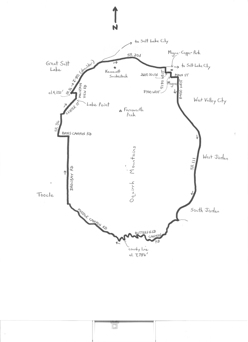
The county line signifies a change in roadway funding and maintenance, as the pavement ends, and the surface is now dirt. The opening descent is steeper than the climb, at a gradient of 12.1%. Take it slow along here, as the pavement resumes after the road negotiates a series of switchbacks and steep drop-offs. The dirt road has had a washboard surface in the past, so an option would be to walk this segment. Back on pavement, Middle Canyon Road continues to descend at a gradient of 7.1%. At mile 28.5 of the ride, leave Middle Canyon and enter Tooele Valley, a few miles past the midpoint of the ride. With its continuing growth, the Tooele area is destined to become Utah’s fifth official urbanized area. Enter the city of Tooele as you turn right onto Droubay Road, to head north. Droubay skirts the eastern edge of the city and the valley, generally descending. Turn left onto Bates Canyon Road at mile 34.8, followed by a right onto busy State Route 36. Although there is a shoulder, you may be grateful to get off this highway by making a right turn onto Center Street. The road bends to the left, and heads into the community of Lake Point. Turn left onto Mountain View Road and head north. Turn left onto Saddleback Boulevard, maneuvering around the traffic circle, and head west, returning to State Route 36. Turn right here and head north – this area, just off the I-80 freeway, is a busy interchange with gasoline stations, convenience marts, eateries, and truck stop facilities. Watch out for turning traffic. Continue passing through, perhaps stopping for refreshment, and enter the I-80 freeway. The next 2.5 miles are along the shoulder of this freeway, as you travel along the narrow passageway between the northern flanks of the Oquirrh Mountains and the Great Salt Lake, which is to your left. The lowest elevations of the ride, at 4,232 feet, are along here.
Exit I-80 at the State Route 201 junction at mile 45.4 of the ride, and head east along this expressway, re-entering Salt Lake County. To your right is the 1,215-foot high Kennecott Smokestack, which serves as a vent for that corporation’s copper smelting operations. Although the smokestack is a record-breaker, being the tallest free-standing structure west of the Mississippi River, it is also the greatest single source of air pollution along the Wasatch Front. Hold your breath as you pass by, to minimize your inhalation of lead, cadmium, arsenic, and mercury. Continue eastward along route 201; turn right onto 9180 West and re-enter the community of Magna. Turn left onto 2600 South and head east. Magna-Copper Park will be on your left after about one-fourth mile. End the ride here.
For more rides, see Road Biking Utah (Falcon Guides), written by avid cyclist Wayne Cottrell. Road Biking Utah features descriptions of 40 road bike rides in Utah. The ride lengths range from 14 to 106 miles, and the book’s coverage is statewide: from Wendover to Vernal, and from Bear Lake to St. George to Bluff. Each ride description features information about the suggested start-finish location, length, mileposts, terrain, traffic conditions and, most importantly, sights. The text is rich in detail about each route, including history, folklore, flora, fauna and, of course, scenery.
Wayne Cottrell is a former Utah resident who conducted extensive research while living here – and even after moving – to develop the content for the book.