By Wayne Cottrell — The Mirror Lake Scenic Byway by Bike is an out-and-back road ride starting and finishing in Evanston, at Bear River State Park. The Kamas-to-Evanston (later Evanston-to-Kamas) Road Race was a fixture on the cycling calendar for years, covering an 80-mile distance along the Mirror Lake Scenic Byway. Later, the race started and finished in Evanston; the ride described in this article is a longer, 100.5-mile alternative. The entire route is at high altitude, starting at Evanston’s 6,750 feet, climbing to Mirror Lake and the nearby Bald Mountain Pass, at 10,700 feet, and returning to Evanston. Note that the Mirror Lake Scenic Byway, which is State Route 150 in Wyoming (WY 150), and State Route 150 in Utah (UT 150), is closed during the winter, generally opening in late spring. Nearly the entire ride is along this route. Perhaps by the time this article is in print, the route will be open, just in time for you to get out there! Bring an extra lung, if you have one, for the thin air of the route’s upper reaches. Also, be prepared for cooler temperatures at the highest elevations.
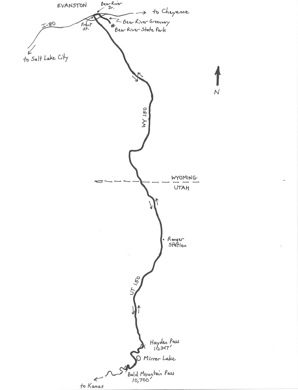
Start the ride at Bear River State Park, located at 601 Bear River Drive in Evanston, on the city’s east side. From the parking area nearest the entrance, ride onto the Bear River Greenway, heading westward (i.e., away from the park). The Greenway is a paved bike path that parallels the Bear River. The path passes under I-80, and then, after a pleasant riverside stretch, passes adjacent the Bear River Ponds (iced over in winter). Stay to the right at the far end of the pond; after passing under U.S. Highway 89, keep right as the path heads toward Bear River Drive. At the end of the path, turn left onto Bear River (the road, not the actual river). Having just ridden along the car-free Greenway, prepare for some motor vehicle activity on Evanston’s streets. After riding under the railroad tracks – the elevated walkway on the right is an alternative to the narrow roadway passage – turn left onto Front Street, adjacent Depot Square. After crossing U.S. 89, Front Street becomes WY 150. After passing under I-80 again, 1.9 miles into the ride, WY 150 heads toward the southern limits of Evanston. Although some sources indicate that the scenic byway does not begin until WY 150 reaches the Utah border, the official scenic byway actually begins as soon the highway heads south of I-80.
Leave Evanston at mile 3.5. The highway climbs gradually, but steadily, from here. Cross the meandering Bear River 9.0 miles into the ride. At about 350 miles in length, the Bear River is the longest river in North America that does not empty into an ocean. As is typical of southwestern Wyoming, once outside of Evanston, expect to see wide open spaces, vast prairies, an arid, reddish-brown landscape, and plenty of howling winds. Settle into a rhythm, because this is a long ride! WY 150 heads generally southeast-ward, gradually turning to toward the south, and then southwest-ward, and finally westward, for a stretch. The highway then makes a sharp bend to the left 21.35 miles into the ride. You are now heading south again, reaching the Utah border at mile 24.95. Approximately 25% of the route is complete, and the elevation is just under 8,000 feet. The highway – now UT 150 – continues its gradual ascent at an average grade of 1%. Enter Uinta National Forest at mile 29. The Bear River split just north of here; you are now riding adjacent the river’s east fork. At the Bear River Ranger Station, the highway’s grade increases noticeably, as the byway starts to climb into the Uinta Mountains. The Uintas are unusual in that they are oriented east-west – most U.S. mountain ranges run north-south. A number of the Uintas exceed 12,000 feet in elevation, and a few top 13,000 feet, including Kings Peak, which is the highest point in Utah at 13,528 feet. Kings Peak is well east of here. The Uintas are taller but “gentler” than the rugged Wasatch Range. There are a number of trailheads and campgrounds that are accessible from UT 150. You may not care much about any of this, though, as you pedal upward. Enjoy the breathtaking, alpine scenery, as you catch your breath. Your first challenge is Hayden Pass, coming at mile 45.5. After cresting this mighty pass, at an elevation of 10,347 feet, you may think that you have reached nirvana – particularly after the ensuing descent takes you within sight of beautiful Mirror Lake. The lake, I believe, is at exactly 10,000 feet. But, the highway tips upward once again, continuing onto the steepest climb of the ride, taking you from the lake to Bald Mountain Pass (elevation 10,700 feet). The Bald Mountain Overlook, on the side of the highway, is the ride’s turnaround point.
For those who are game, there is a brisk, steep trail that leads from the overlook to Bald Mountain (elevation 11,943 feet). Otherwise, now at mile 50.25, start the return ride by heading north on UT 150. As noted above, the highway descends steeply to Mirror Lake, and then climbs gradually to Hayden Pass. Once over the Hayden crest, the next 15 miles are a ripping descent. The grade eases beyond the Bear River Ranger Station, although the highway is still heading downhill. Leave Uinta National Forest at mile 71, and re-enter Wyoming at mile 75.05. Depending on the direction of the wind, the right-hand bend at mile 79.65 may be a blessing or a curse. Note that the orientation of WY 150 changes several times before returning to Evanston. Hopefully, one of those orientations will find you catching a tailwind! Re-enter Evanston at mile 97. The highway has widened, and civilization has returned. Be prepared for an increased volume of motor vehicles as you near I-80 (mile 98.6), and continue onto Front Street. After making the right turn onto U.S. 89, be particularly cautious as the road dips under the railroad tracks. The walkway on the left is an alternative. Turn right onto Bear River Drive, and then right again to access the Bear River Greenway. From here, it is pleasant 1.15-mile, car-free bike path back to Bear River State Park.
GPS coordinates (Bear River State Park): 41.266111oN 110.936944oW
For more rides, see Road Biking Utah (Falcon Guides), written by avid cyclist Wayne Cottrell. Road Biking Utah features descriptions of 40 road bike rides in Utah. The ride lengths range from 14 to 106 miles, and the book’s coverage is statewide: from Wendover to Vernal, and from Bear Lake to St. George to Bluff. Each ride description features information about the suggested start-finish location, length, mileposts, terrain, traffic conditions and, most importantly, sights. The text is rich in detail about each route, including history, folklore, flora, fauna and, of course, scenery.
Wayne Cottrell is a former Utah resident who conducted extensive research while living here – and even after moving – to develop the content for the book.