By Wayne Cottrell
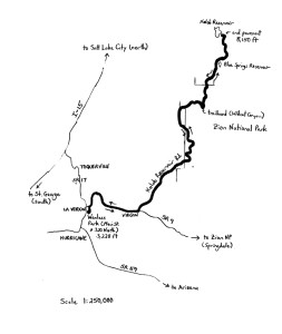
The Kolob Terrace Challenge is a strenuous, 61.4-mile road bike ride in southwestern Utah. The out-and-back ride starts and finishes in La Verkin, which is located immediately north of Hurricane. The route penetrates and then leaves the central area of Zion National Park, as it climbs from an elevation of 3,228 feet, in La Verkin, to 8,150 feet at the turnaround point, adjacent Kolob Reservoir. The elevation difference is a whopping 4,922 feet. A good level of fitness is highly recommended for the ride, although, since it is an out-and-back course, the rider can easily turn around at any point along the way. The route’s main feature is its exploration of a region of Zion National Park that is less visited than its more well-known park counterparts. Be prepared for triple-digit temperatures during the warm seasons.
Start the ride in La Verkin, a small but growing city located 21 miles to the northeast of St. George, along State Highways 17 and 9. La Verkin had a population of 4,719 in 2010, reflecting a staggering 40% increase over its year 2000 population. The otherwise quiet city made national headlines in 2001, when the city council declared La Verkin a “United Nations-free zone.” Meaning that any U.N. supporting residents must file an annual report, and affix an outdoor sign, or else be cited with a misdemeanor. The apparent U.N. malcontent is actually a tame issue compared to the mid-1990s headquartering of a group of “skinheads” in La Verkin, who aimed to convert Zion National Park into an Aryan Nation homeland. Whatever – never mind the politics; we are just here to ride, right?
From Wanless Park, located at Main Street and 320 North, head north on Main Street. Turn right onto 500 North, which is State Route 9. This is the main highway to Zion National Park, so traffic can be seasonally heavy. The highway climbs 500 feet over the next two miles, through the Hurricane Cliffs, to Hurricane Mesa. After a series of false flats and gradual descents across the desert scrub, the highway enters Virgin (population 596 in 2010). A short, steep drop followed by short, steep climb marks the entry into town. Virgin earned its share of national notoriety when, in 2000, a law was passed requiring every homeowner to own a firearm. Exceptions are made for conscientious objectors, convicted felons, the mentally ill, and the impoverished. As a cyclist who is just passing through, don’t rile any residents, and everything will be fine.
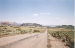
At mile 6.5, look for Kolob Road – also known as Kolob Reservoir Road, or even Kolob Terrace Road – on the left. Turn left here and get off the beaten path. This road, listed in some places as a Scenic Backway, is paved all the way up to Kolob Reservoir. Climbing and cattle guards begin after just one-half mile; the road rolls and winds for the next several miles. Cattle guards are spaced every one to three miles from here. The scenery is typically majestic, Navajo sandstone cliffs and desert forestation. At mile 10.1, the road begins to climb more steeply, although the climbs are frequently interrupted by short descents. At mile 11.3, an outcropping of black lava rock (basalt) appears on the right. Such outcroppings, fairly common in this region, are suggestive of “recent” volcanic activity (20,000 to 2 million years ago). Just to get your bearings, the Sunset Canyon Ranch is on the right at mile 11.6. Enter Zion National Park around mile 12. At mile 12.7, the majestic peaks of central Zion National Park come into view, particularly the North and South Guardian Angels, which stand on either side of the Great West Canyon. Tabernacle Dome is in the foreground, on your right, between miles 15 and 16. Leave Zion National Park at mile 17.2.
 Was that it? No – at mile 18, Kolob Reservoir Road has the appearance of a ribbon of asphalt, stretching skyward. Just beyond the crest of this one-mile climb, re-enter Zion (mile 19.2); you are now on Lower Kolob Plateau. A reddish tint permeates the landscape out here, evidence of the oxidization of minerals in the surface rocks. The scenery (and the climbing) continues to take your breath away, with Firepit Knoll and Job’s Head on your left, and Spendlove Knoll and the north side of North Guardian Angel to your right. The Hop Valley trailhead is on your left; from here, hikers can descend 1,000 feet to La Verkin Creek to view lovely meadows, 600-foot tall cliffs, and Kolob Arch (second-longest in the world). At the switchback at mile 21.6, the Wildcat Canyon trailhead serves as a takeoff point for hikers heading to Subway Canyon (a famous slot canyon, in which water from Left Fork North Creek flows through a tubular canyon with limited lighting). Leave Zion National Park (again) at mile 25.2, as you reach the Upper Kolob Plateau. Note that, from here, Kolob Reservoir Road can be closed from November through March for the winter season, depending on the accumulation of snow.
At mile 27.5, Blue Springs Reservoir appears on the left. This small, beautiful body of water follows a passage through a meadow that offers a stark contrast to the rugged desert scenery of the lower elevations. Enter “Kolob” – an unofficial name for the small settlement here – at mile 28.5. Note the grove of quaking aspen trees, recently voted by the Utah State Senate (as of this writing) to become Utah’s new State tree. As for Kolob, it is the name of the star at the center of the universe, nearest to the “throne of God,” according to Mormon church doctrine. The road continues to climb until it finally reaches Kolob Reservoir, at mile 30.7, and an elevation of 8,150 feet. The pavement ends at the lake. Take time to refresh (there are lavatories). If the temperature exceeds 100 degrees in La Verkin and Virgin, then it should be no higher than the mid-80s up here.
Although Kolob Reservoir Road continues northward as a dirt road, turn around here and begin the descent back toward Hurricane Mesa. The descent is interspersed with plenty of short climbs. Where the road is steep and winding, be sure to control your speed. The road enters and exits Zion National Park twice on the way back, as you descend from the Upper Kolob to the Lower Kolob Plateau. Make the right turn from Kolob Reservoir Road onto State Route 9 at mile 54.9, and re-enter Virgin. While passing through, take time to notice the whimsical old-west buildings and facades of the Fort Zion Gift Shop. After a brisk, two-mile descent off of Hurricane Mesa, turn left, at mile 61.2, onto Main Street in La Verkin. Look for Wanless Park on the right at mile 61.4.
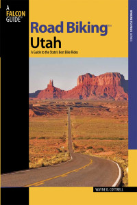 For more rides, see Road Biking Utah (Falcon Guides), written by avid cyclist Wayne Cottrell. Road Biking Utah features descriptions of 40 road bike rides in Utah. The ride lengths range from 14 to 106 miles, and the book’s coverage is statewide: from Wendover to Vernal, and from Bear Lake to St. George to Bluff. Each ride description features information about the suggested start-finish location, length, mileposts, terrain, traffic conditions and, most importantly, sights. The text is rich in detail about each route, including history, folklore, flora, fauna and, of course, scenery.
Wayne Cottrell is a former Utah resident who conducted extensive research while living here – and even after moving – to develop the content for the book.