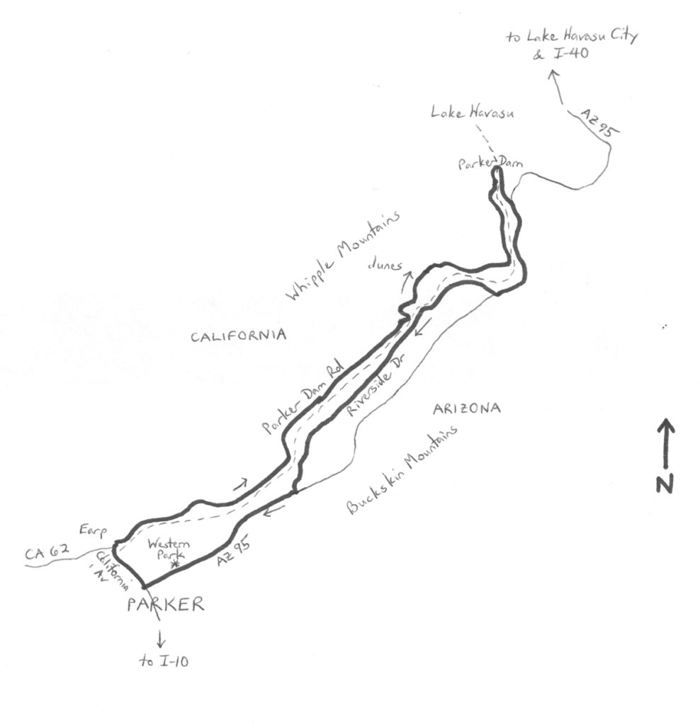
By Wayne Cottrell — As winter sets in, especially in northern Utah, it is best to head south for warmer weather, and conditions that are more suitable for road biking. Of course, one can road bike in just about any weather, with proper clothing and equipment, but mild to warm temperatures are admittedly more comfortable. Most of Arizona, for example, is great for wintertime cycling. South of Salt Lake City – 600 miles, in fact – is Parker, Arizona (180 miles south of Las Vegas). This city of 3,100 residents is located 155 miles west northwest of Phoenix, along the Colorado River (and the California border). A town was established here in 1871 as a kind of headquarters for the nearby Colorado River Indian Reservation, and as a place to drop off cargo and personnel (a railroad bridge across the river was nearby). The city of Parker incorporated in 1909. Later, during the 1930s, Parker Dam was built to the north of the city. The dam facilitates hydroelectric power generation, and is the southern end of Lake Havasu, which the dam created. The concrete arch-gravity dam is 320 feet high, but 235 feet are below the riverbed, making it the deepest dam in the world. The old dam access road – Parker Dam Road – is a scenic, backcountry byway (in California – the dam is in California). This ride incorporates the scenic byway, which is part of the Bureau of Land Management’s network of scenic and historical backcountry roads.
To get to Parker, head south on I-15. In Las Vegas, transfer to U.S. 95 south, which enters California. Next, transfer to I-40 eastbound, entering Arizona. Finally, head south on Arizona State Highway 95 (AZ 95). Note that AZ 95 is different from U.S. 95. AZ 95 passes through Lake Havasu City, on its way to Parker.
The Parker Dam Ramble starts in Parker at Western Park, located at Riverside Drive (AZ 95) and Desert Avenue. The park’s GPS coordinates are at the end of the article. The 32.8-mile ride is not particularly long, but be sure to bring plenty of fluids with you. In fact, one article notes that Parker can get “dangerously hot” during the summer months – a wintertime ride should help you to avoid summer temperatures that can exceed 110 degrees. The lowest elevation is 371 feet, and the highest is 500 feet – there are a few hills, but no long, extended climbs. Head southwest on AZ 95; turn right at the traffic signal, onto the aptly-named California Avenue. Indeed, the road enters California after a short stretch, crossing the Colorado River. Got your passport? Well, you won’t need it, but you may need to reset your watch, as California and Arizona are not in the same time zone! After passing under a railroad bridge, and experiencing a number change – you are now on CA 62 – the road comes to an abrupt end (T-intersection) at Parker Dam Road. Turn right here, at mile 1.65, and head northeast. This is the most scenic segment of the ride, so enjoy! There are a few riverside developments as you ride along, on your right, including camp sites, mobile home parks, lodges, and resort communities. You may also see some wild burros near and along the road. This segment of the ride is mostly flat until mile 12, where a short climb (less than one-half mile; 5% grade) takes you to the highest elevation of the route (500 feet). If you cannot always see the Colorado River, which is to your right, then you can certainly see the Copper Basin Dunes, which are to your left. In places, the dunes practically encroach upon the road. Enter the tiny community of Parker Dam at mile 16.8, as the dam itself comes into view. There are some great photo ops as the dam gets close. Stay to the left at the large pullout area on the right. The road rolls right over the dam (mile 17.4). The signing suggested that there were some restrictions on bicycles for the short dam segment, but I rode across with no issues.
Continue beyond the dam as the road curves to the right, and descends gently, now heading south. You are back in Arizona (La Paz County); be sure to reset your timepiece. Merge onto AZ 95, which will be coming in from the left, at mile 18.1. Traffic slows as you pass through the small River Lodge Resort community. The highway climbs (3% grade) from here, with the Buckskin Mountains on the left. There are rumble strips on the shoulder, making this segment awkward for a cyclist. River Island State Park is on your right at mile 21 – a great place to stop if you are out of water. Bear right onto Riverside Drive, taking you off of AZ 95, at mile 22.3. Another State park, Buckskin Mountain, is to the right, just beyond the turn. Both of the parks border the Colorado River. Riverside Drive is a pleasant alternative to the state highway, passing through a number of riverside communities and resort developments. You are now heading in a southwesterly direction. There are a few, short hills and descents along the way. La Paz County Park is on the right at mile 25. All of the communities and developments through which the road passes have a Parker address, although the main city of Parker is several miles to the southwest of here. Return to AZ 95 at mile 28.85; turn right to continue heading southwest. Access to the Blue Water Resort (and Casino) is on the right at mile 31.75. If you are in Parker, you go to Blue Water. It’s what you do. From here, it is just another mile to Western Park, where the ride ends.
GPS coordinates of Western Park: 34.153217oN 114.282806oW
For more rides, see Road Biking Utah, Best Bike Rides Los Angeles, and Best Bike Rides San Francisco (all from Falcon Guides), written by avid cyclist Wayne Cottrell. Each book features descriptions of approximately 40 road bike rides. The ride lengths range from 14 to 106 miles. Each ride description features information about the suggested start-finish location, length, mileposts, terrain, traffic conditions and, most importantly, sights. The text is rich in detail about each route, including history, folklore, flora, fauna and, of course, scenery.
Wayne Cottrell is a former Utah resident who conducted extensive research while living here – and even after moving – to develop the content for the book.