The Marin Headlands Excursion is an exciting and reasonably challenging 22.7-mile ride in southern Marin County in northern California’s Bay Area. It covers an extremely popular road cycling route; a similar ride has even been written up in the revered Huffington Post. The ride is also featured in my Best Bike Rides San Francisco book, although my versions do not include a crossing of Golden Gate Bridge. My forthcoming Best Easy Bike Rides San Francisco will include the crossing, though. The reader is referred to these books for more detailed descriptions. This article provides enough information for a cyclist who wants to ride here, though. The ride tours the roads of the Marin Headlands, which is a hilly peninsula area located just north of San Francisco. Except for some old U.S. military facilities, and some current park buildings, the Headlands remain mostly undeveloped. The highest point is Hawk Hill, at 920 feet. The ocean coastline is generally rugged. The Headlands has its own microclimate that ranges from clear and calm, to foggy with fog drip condensation, to cloudy and rainy, to windy with gale force gusts. There are clear days during all seasons of the year, though, so take a chance and get out here!
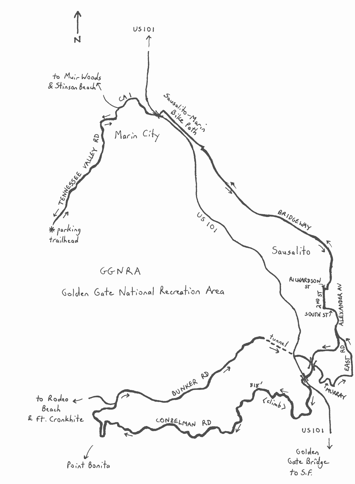
This version of the ride differs from others in that it starts on the north side of the Marin Headlands, in Tennessee Valley. Tennessee Valley Road comes to a dead end, with a large parking area, at a popular trailhead, making this is a logical starting point for a road ride. While most others here will be headed onto the trails, you will be the maverick heading in the opposite direction, onto Tennessee Valley Road. The staging area is one of numerous such points in the massive Golden Gate National Recreation Area (GGNRA). The GGNRA covers over 82,000 acres, contains 19 different ecosystems, and is larger than the city of San Francisco. The GGNRA, which is really a large urban park, stretches from southern San Mateo County, well south of San Francisco, to northern Marin County, well to the north, along the ocean and reaching inland. Many of the GGNRA’s lands were formerly owned by the U.S. military, so it is pleasing that there has been a transition to peaceful uses. Tennessee Valley Road (two lanes) descends from the parking area at the trailhead into the southeast corner of Tamalpais Valley, near Tamalpais Valley Junction. Tennessee Valley – the actual valley – heads in the opposite direction of the road, toward the ocean. (So, the road does not pass through Tennessee Valley). At the end of the road, after a few undulations and exciting curves, turn right onto California Highway 1 (CA 1). This is a busy segment of highway, carrying 32,500 motor vehicles per day in only two lanes. When traffic is really heavy, queues form, and you may happily whiz by the stacked-up vehicles. Continue on CA 1 under U.S. 101, curving to the right. At the signal, turn left, onto Pohono Street, and then immediately turn right onto the Mill Valley-Sausalito bike path. This is a heavily used bike connector between points south and points north. There is no alternative to the bike path between Pohono Street and the next street, which is North Bridge Boulevard.
Turn right onto North Bridge Boulevard, and then turn left immediately, at the traffic signal, onto Bridgeway Boulevard. Only in rare circumstances would you be the only rider executing this maneuver! Watch for traffic, nonetheless. Bridgeway Boulevard heads south, streaking into the city of Sausalito via a series of false flats and traffic signals. Sausalito had a population of 7,100 in 2018. The city was isolated until the introduction of an auto-ferry from San Francisco in 1926, and then the completion of the Golden Gate Bridge in 1937. On the left, near the northern limits of the city’s commercial district, is the Bay Model. This is a working replica of the San Francisco Bay and the Delta region farther to the east. The model is indoors, and includes exhibits and tours. As you enter the commercial district, your speed reduces amidst the motor vehicle, bicycle and pedestrian traffic. All along Bridgeway and a few side streets are notable restaurants, bars and inns. Plus, the waterfront features outstanding views of San Francisco and Angel Island. There can be a constant stream of cyclists pedaling through here.
As you leave the commercial district, the road bends sharply to the right, becoming Richardson Street. The street climbs to 2nd Street, at which a left turn keeps you on the main route. While climbing, take a look up at some of Sausalito’s hillside residences. William Randolph Hearst’s hillside mansion “Sea Point,” which was never completed, inspired his San Simeon castle. 2nd Street takes a dip to Main Street, then climbs sharply to South Street. Turn left here to continue on the main route. South Street stays level briefly, and then climbs, bending to the right to become Alexander Avenue. This street continues to climb, leaving Sausalito’s development and entering the undeveloped fringes of the GGNRA. After crossing over Bunker Road (you will return this way), continue through the often-windy gap between the two knolls. Be especially cautious at the “T” intersection with Danes Drive just prior to the gap – my experience is that motorists (many of whom are probably tourists) often seem unaware of cyclists’ movements and intentions here. Continue underneath the U.S. 101 freeway – the passage is narrow and dark, so be especially alert. On the other side, bear right onto Conzelman Road (continuing straight puts you on U.S. 101 and the Golden Gate Bridge, in freeway traffic).
Conzelman Road is a gateway to the Marin Headlands. The road rapidly leaves the busy Golden Gate Bridge environs, climbing at an average gradient of 10% to an elevation of 430 feet, and a fabulous overlook of the Golden Gate Bridge. It can be equally as busy up here as it is down at the bridge, as the viewpoint is very popular. Continue as Conzelman winds its way high above the water. Continue through the traffic circle; the road steepens beyond here. The climb finally eases at Hawk Hill, the highest elevation of the entire ride (818 feet), adjacent some old World War II infrastructure. A large number of raptors are attracted to this hill, in part because of updrafts and thermals that enable the birds to fly very efficiently. Continue on Conzelman as it descends sharply toward the ocean below, on a one-way road. This is an unsurpassed view of the ocean, and is not to be missed! If it is foggy, then plan on doing this ride again on a clear day. The Conzelman descent continues for a couple of miles. The road is one way, and there is usually very little traffic. Conzelman begins to undulate toward the end of the descent, as it passes by, then curves away from Bonita Cove. Point Bonita, well to the left, represents the last gateway between the San Francisco Bay and the Pacific Ocean. California’s oldest lighthouse and fog signal are located out here. Despite the beacon and audible warnings, hundreds of ships have run aground near the Golden Gate.
As Conzelman curves to the right, the road passes by a series of batteries, some built before World War I, and others from World War II. All of the military sites have been decommissioned. Once around the curve, you are on Field Road. After another fast descent, the Marin Headlands Visitor Center appears on the left. At the base of the descent, bear right onto Bunker Road. Note that, to the left, Bunker Road continues to Rodeo Lagoon and, just beyond it, Rodeo Beach. The beach is one mile away, and is unique in California for the red and green pebbles that comprise its surface, as opposed to sand. Swells form offshore, making the beach suitable for surfing. When the beach is inundated, usually during winter months, Rodeo Lagoon empties directly into the ocean. Across from the lagoon is Fort Cronkhite, which was active from 1941 to 1974, and is now on the National Register of Historic Places.
Back on Bunker Road, this is the main “valley” road, heading eastbound, gradually climbing through the Headlands. The road is narrow, with some pavement damage when I rode this. Side streets along the way, to your right, return to the ridge and Conzelman Road. The dirt trails to the left penetrate Gerbode Valley, and provide access to other valleys within the Headlands. Bunker Road crests at the mouth of a half-mile long, one-lane tunnel that cuts through the ridge and underneath U.S. 101. Only one lane? Right – traffic flow in the tunnel is controlled by a signal that lets only one platoon of vehicles in one direction through at a time. Bicyclists need not wait for the signal, however. A separate pushbutton for cyclists, located at the entrance to the tunnel, alerts motorists to the presence of a bike in the tunnel. The tunnel is designed to accommodate two-way bicycle flow. Tunnel lighting is adequate but, once inside, it might seem longer than one-half mile!
Exit the tunnel, and turn left at the “T” intersection to continue on Bunker Road. The road curves to the right and descends rapidly, passing underneath Alexander Avenue, to Fort Baker. The fort is deactivated, and is now the home of the Bay Area Discovery Museum, a popular spot for families. To navigate Fort Baker’s roads, turn right at the stop sign onto Murray Circle. Next, turn left at the stop sign onto East Road, just up the road from Horseshoe Bay. East Road passes by the Museum, which is on the right, and then climbs gradually, adjacent San Francisco Bay, to intersect with Alexander Avenue. Turn right here, and begin the descent into Sausalito. Note that cyclists coming directly from the Golden Gate Bridge will have started their downhills upstream of here, and may possess quite a bit more speed than you. So, do not be alarmed if a number of riders go zooming past! You are now riding in the reverse direction of the outbound route. Continue via Alexander, South, 2nd, Richardson, Bridgeway, North Bridge, and the Mill Valley-Sausalito bike path, generally following the prevailing pattern of flow. Turn left at Pohono, and then right on CA 1. The busiest segments of the return ride will be along CA 1, followed by the left turn onto Tennessee Valley Road – use caution here. The return ride on Tennessee Valley Road is uphill, getting steeper toward the end, to the unpaved parking area and the end of the ride.
Starting & ending point coordinates: 37.860175oN 122.535978oW
For more rides in the Bay Area, see Best Bike Rides San Francisco (Falcon Guides), written by avid cyclist Wayne Cottrell. Best Bike Rides San Francisco features descriptions of 40 road and off-road rides in the Bay Area. The ride lengths range from 4 to 60 miles, with rides in San Francisco, the East Bay, and Marin County. Each ride description features information about the suggested start-finish location, length, mileposts, terrain, traffic conditions and, most importantly, sights. The text is rich in detail about each route, including history, folklore, flora, fauna and, of course, scenery. For additional rides in California, all written by Wayne Cottrell, please also see the Best Bike Rides books on Los Angeles and Orange County, as well as the forthcoming Best Easy Bike Rides books on Los Angeles, Orange County, and San Francisco. Wayne Cottrell is a former Bay Area and Utah resident, and current southern California resident, who continues to conduct extensive research in these places, and elsewhere, to develop the content for bike books.