By David Collins —
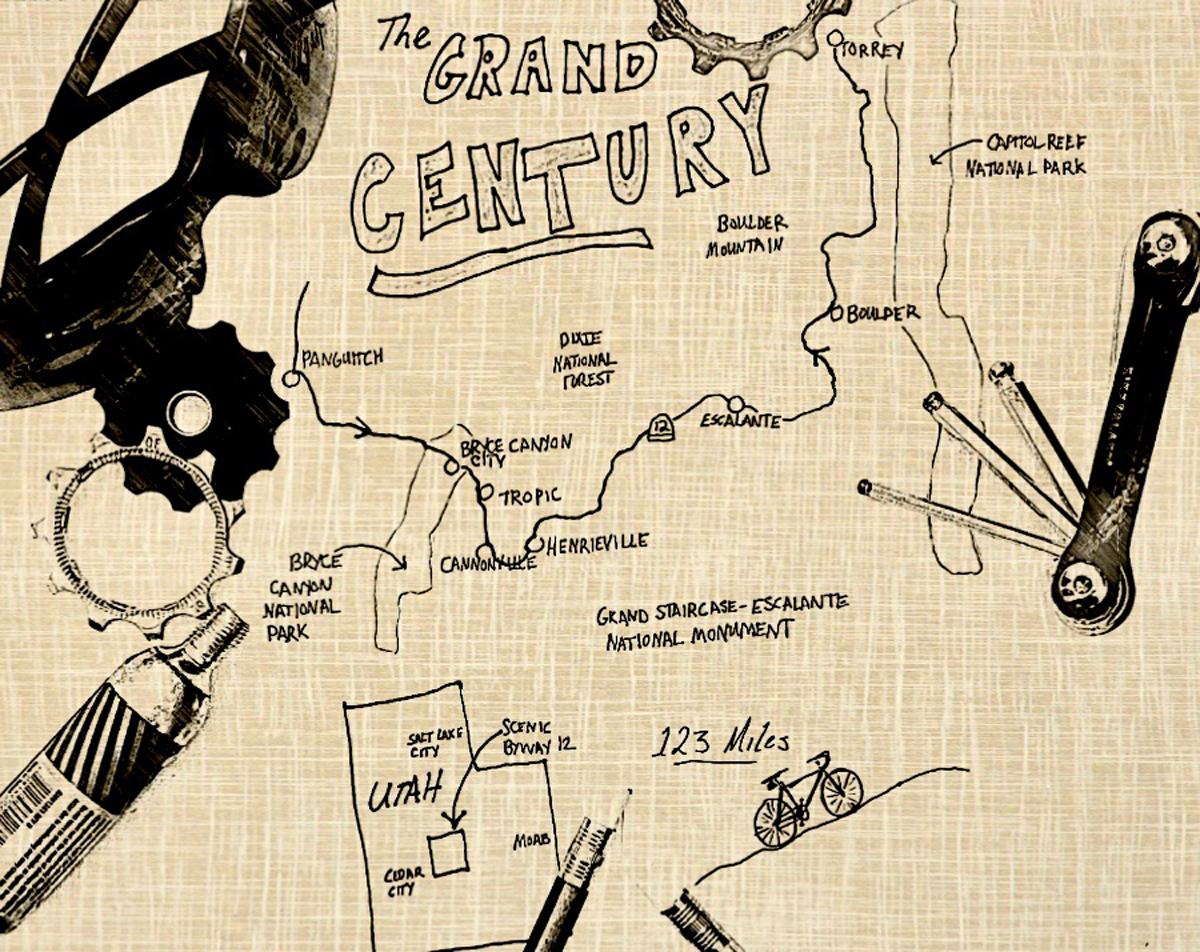
123 Miles of Cyclist Friendly Scenic Byway Adventure
Although parts of this scenic byway show many faces and feature common nicknames, it seems to me The Grand Century is an appropriate name for rolling through it on a bicycle. The Grand Century is a suitable name for three reasons:
- It’s no ordinary byway and it entraps your attention with its beauty in a grand way.
- It’s 23 miles longer than the usual century ride of 100 miles
- It winds through the heart of the Grand Staircase-Escalante National Monument.
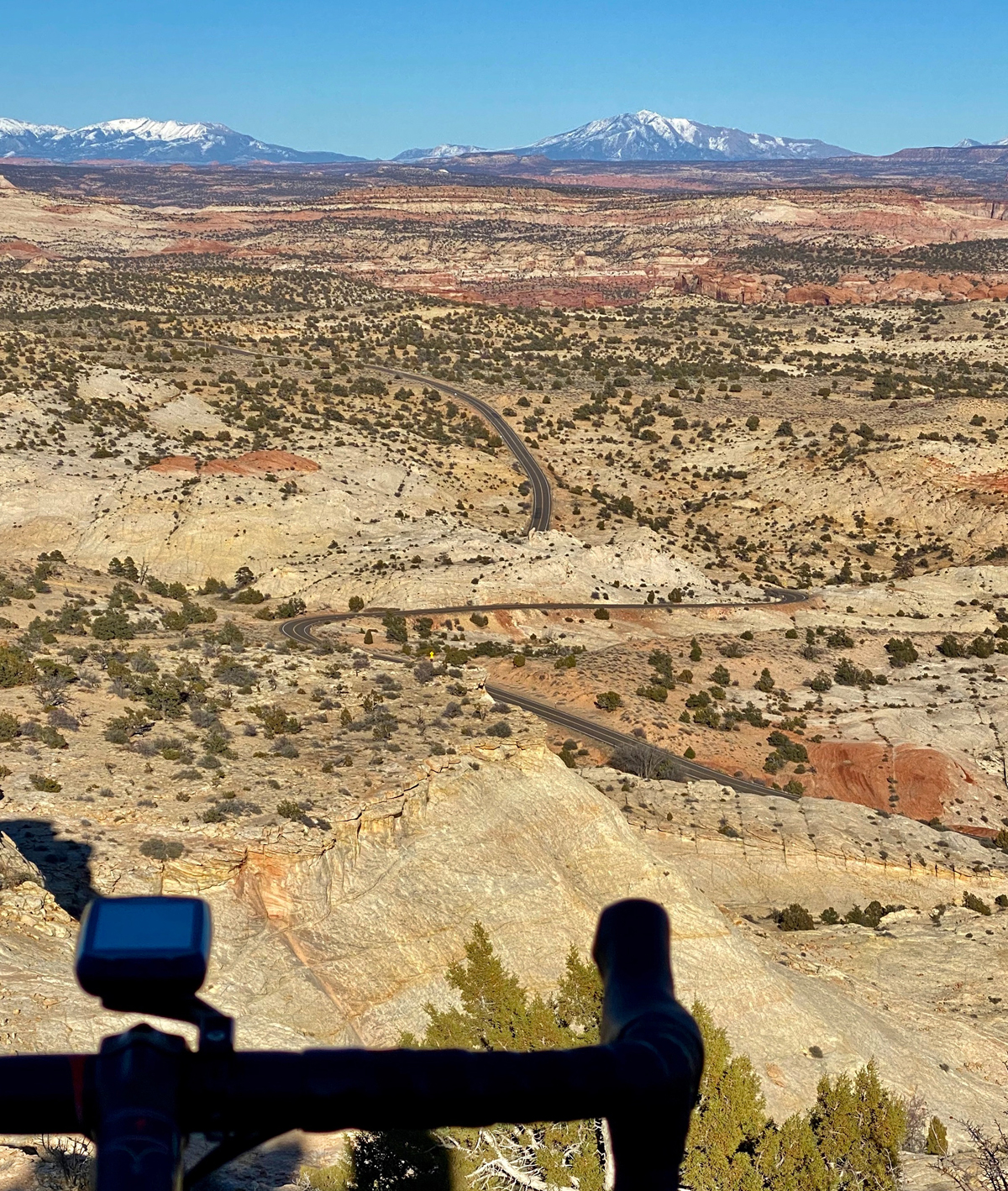
The route is bathed in stunning scenery, clips a national park, features charming townships, dramatic alpine overlooks, red cliffs and a stretch dubbed “The Million Dollar Road”. It’s a cyclist’s dream – filled with unforgettable imagery and points of historical interest.
Extended shoulder seasons are usually the best time to ride but depending on your skills, equipment, local conditions and road closures, you might be able to ride it throughout much of the year. Be weather aware, riding conditions can swiftly change.
Excursions and explorations are part of the fun of unsupported bicycle touring at your own pace. Mileage estimates are approximate and may vary depending on your tracking system and whims of the ride. Be sure to tell someone your plans and allow them to track your location using a smartphone or other device.
Solo or unsupported distance cycling often presents potentially dangerous situations related to terrain, weather, equipment, traffic, navigation and mental awareness. Even experienced cyclists must plan carefully and use wise judgment to successfully mitigate inherent risks of the sport or terminate a ride before it turns injurious or deadly. If you are new to the sport or have never ridden a bicycle more than 100 miles in a single day, learn the ropes with a seasoned buddy or local cycling club before strapping on this ride.
Make sure to check maps, plan your route and check local road conditions before you go. As with any ride, be aware of your surroundings and of roadway traffic.
Time to fill water bottles, stuff gear bags, click in and start pedaling The Grand Century.
Route:
Scenic Byway 12. Begins in Panguitch and through Bryce Canyon City, Tropic, Cannonville, Henrieville, Escalante and Boulder – ends in Torrey. 123 miles.
Terrain:
All paved. Three high mountain passes (one of which tops out above 9600 feet), canyons; river bottoms; long rolling risers; open range; agricultural zones and winding/bending undulated miles throughout. Although there are multiple cycling (Share the Road) signs posted along the way, many segments have narrow (or no) paved shoulders and sharp curves.
What to See:
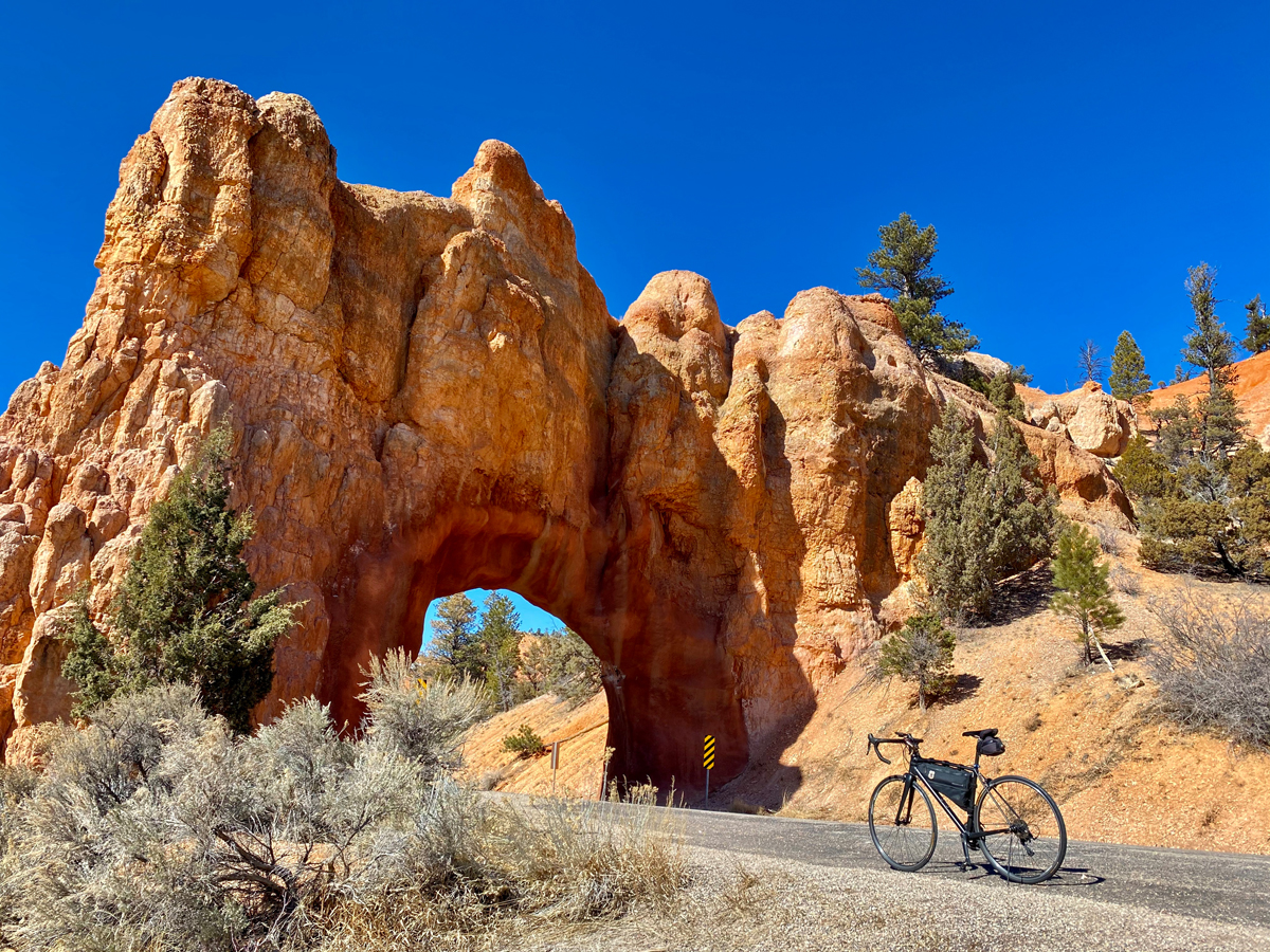
Geologic wonders including volcanic tuff, prehistoric landslides, slumps, columnar joints, basaltic boulders, hoodoos, honeycomb cliffs, stonepecker holes, exposed ancient bedrock strata and bubble caves; active and temporarily dormant rivers (Pariah, Escalante); Red Canyon; Dixie National Forest; giant cliff curtain rising behind Cannonville; Kodachrome Basin (see Still Have Legs); The Hogsback section of The Million Dollar Road (a razor thin ridge road with steep cliff drops on either side – proceed with caution and enjoy breathtaking vistas); Anasazi State Park Museum; a short sip of Bryce Canyon National Park; a long swig of Grand Staircase – Escalante National Monument; a handful of charming and sometimes quirky towns (Panguitch, Bryce Canyon City, Tropic, Cannonville, Henrieville, Escalante, Boulder and Torrey); Visitor Centers including: Red Canyon, Bryce Canyon (three miles south of the byway’s junction), Grand Staircase-Escalante National Monument and Escalante Interagency; the original Torrey log schoolhouse; while not quickly accessible on the ride, it’s nice to know there’s evidence of giant prehistoric residents – multiple dinosaur tracks litter the Escalante area (one site contains more than 250, two of which include indications of tail drags).
Selfies and Photo Ops:
Several colorful roadside cliff backdrops (chocolate, vermilion, white, gray and banded); noteworthy overlooks including The Blues, Head of the Rocks, Boynton, Homestead, Larb Hollow and Steep Creek; Red Canyon archways (the road passes through); Bryce Airport sign; Dixie National Forest backdrops; Ebenezer Bryce’s cabin in Tropic; Kodachrome Basin State Park sign; laser-cut steel Welcome to Henrieville sign on the west side of town; Upper Valley Granaries cliff formation (a small stone structure constructed by ancient Puebloans is wedged into the cliff but can’t readily be seen without binoculars); The Hogsback – DANGER – be cautious and only stop when weather permits and the road is empty.
Wildlife:
Mountain lions, bobcats, elk, deer, pronghorn (antelope), black bear, red-tailed hawks, golden eagles, jays, lizards, snakes, fox, coyote, jack rabbits, porcupines and little ground scurriers.
Best Post-Ride Eats:
Red Cliff in Torrey. The table clothes are plasticky, your silver comes in a parchment sleeve and they serve pizza and steak burgers, but don’t let that fool you. Other places may have classier environs or even better fare, but nobody has Red Cliff’s homemade hot plate of meat lasagna. Every day the owner makes a batch of it – a lovely ode to all comfort food. Loaded with meatballish tang and served with shards of parm on top and sweet savory red sauce you’ll sop with breadsticks, it’s the perfect plate of protein and carbs after an extended day in the saddle. The portion is generous, but after you taste the first bite, you won’t be surprised to find yourself ordering another plate when the last bite is gone.
Still Have Legs, lungs and Sunlight?
Add a brief detour through Kodachrome Basin State Park. More than 50 sand pipes ranging from 6 to 170 feet tall can scratch anyone’s geological itch. If you’re carrying lightweight shoes in your gear, shod your dogs and stretch your legs on the wonderous 2.9 Panorama Trail. It won’t take long in your excursion to understand why a National Geographic Society Expedition named the basin after the color perfect Kodak film of the day.
Notes:
- The final major climb tops out above 9600 feet above sea level where weather may deteriorate rapidly and turn into volatile riding conditions including early summer snow showers.
- With three climbs, total elevation for the day is significant. You may want to split this ride into two days.
- Take a hardcopy map, GPS and cell service are often spotty or unavailable.
David Collins is a cycling enthusiast and amateur randonneur. Follow him on Instagram @rockypumpkin