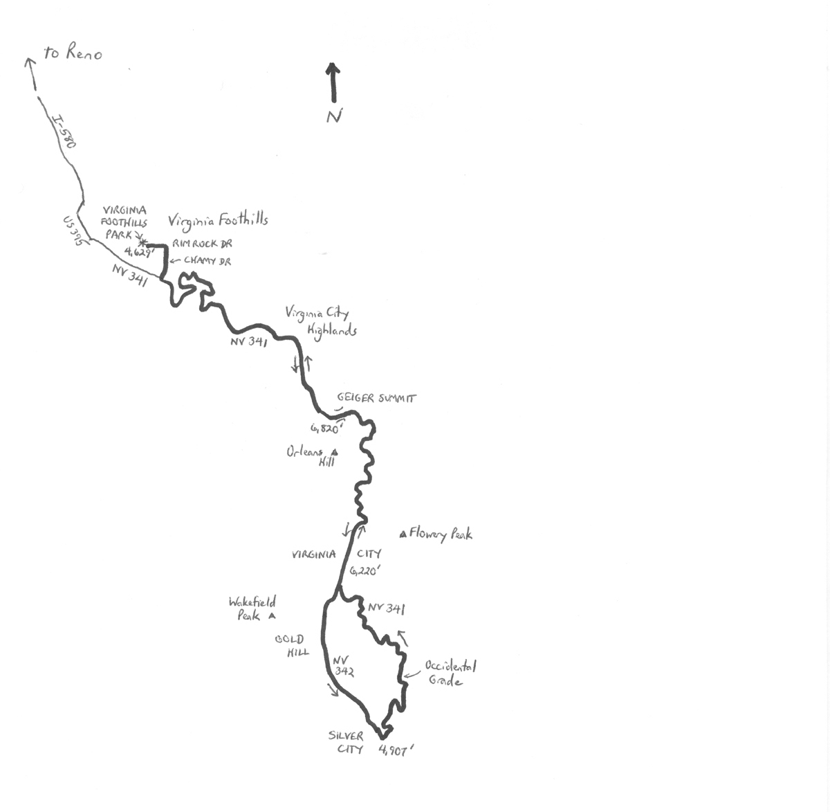
By Wayne Cottrell — The Geiger Grade to Gold Challenge is a history-laden and hilly(!) road bike ride near Reno, Nevada. The 37-mile ride features a climb up to and then through Virginia City, followed by a loop (descent and climb) on Virginia City’s south side, and then a rapid descent to the starting point. The cumulative amount of climbing is a fitness-testing 4,260 ft. The ride starts in the community of Virginia Foothills, located just east of Tahoe Junction, about 11 miles south of Reno. When travelers think of Nevada, most of them are drawn to Las Vegas. But, Reno was the “original” Vegas, until the latter’s aggressive growth overtook the former. Actually, both cities were predated by Virginia City, which was a center of activity during the decades following the discovery of gold in the California Sierras. Gold rushers bypassed the Virginia City area at first, on their way to California’s golden foothills. California’s gold rush began in 1849, and by 1851 prospectors were already looking eastward for more lodes. The story is too long for this article, but, by 1860 – following the discovery of the Comstock Lode, as well as silver amongst the gold – some 10,000 persons were flooding into Virginia City. The town was lawless at best, with shortages of water and other staples, and substandard living conditions – but plenty of booze and bullets.
By 1876, Virginia City’s population hit its peak, at 23,000 – which was half of Nevada’s population at the time (Nevada became a state in 1864; prior to that, the area was concurrently considered to be part of western Utah and eastern California). By the turn of the century, as the excitement of mining waned, folks were packing up and moving on to other adventures. Mining of the Comstock Lode continued through the mid-20th century, however, keeping the town alive. Then, thanks to a television series – “Bonanza” — the Cartwrights managed to pique plenty of folks’ interest in Virginia City’s history. Fast forward to today, and Virginia City entertains several million tourists per year. The town is chock full of museums, historical buildings, recreations, and other great attractions. As for cycling to Virginia City, please be prepared for the occasional lumbering tour bus making its way up the winding climb to the mother lode, from Reno.
As noted above, the ride starts south of Reno, in the community of Virginia Foothills. Although, as Reno grows, this community is more a part of than “south of” the city. To get there, head south from central Reno on I-580. At Tahoe Junction, exit southward onto U.S. 395 (South Virginia Street), followed by a left turn onto Nevada State Highway 341 (NV 341), also known as Comstock Highway. Turn left onto Western Skies Drive, followed by a right turn onto Reading Street, and then a right turn onto Spelling Court, which leads to the park. Begin the ride on the south side of the park (starting elevation: 4,629 ft); head east on Rim Rock Drive, followed by a right turn onto Chamy Drive. Head south on Chamy to NV 341; turn left, and start the climb up Geiger Grade! My memory may be incorrect, but this or a nearby climb may have been ridden in an edition of the long-defunct Coors Classic, some 30 years ago. Three-time Tour de France winner Greg LeMond was from Reno, perhaps cutting his teeth on this road, so you may be visiting some of cycling’s hallowed ground!
The climb up NV 341 is relentless, at an average grade of just under 5%, eventually reaching Geiger Summit (elevation 6,820 ft). From here, it is a gradual descent, and then short climb into Virginia City (elevation 6,220 feet). The route continues straight through town – the ride along Main Street may be slow, with plenty of parking maneuvers and crossing pedestrians. Ease your pace through here, and take some time to look around. Some of the tourists may even be pointing at you (!). The ride returns to town, heading the other way, so you can stop either now or then. Heading south of Virginia City on NV 341, the highway descends precipitously. In fact, watch your speed, as it is a very fast downhill. There is a rest stop on the right, about one mile south of town – time to refresh, particularly if it is hot. Keep right at the junction with NV 342 – you are now on NV 342. The next point of interest is the town of Gold Hill (elevation 5,820 ft). During its heyday, around 1870, 8,000 persons lived here. Most were sharing in the spoils of the Comstock Lode, similarly to Virginia City. Gold Hill has not been preserved as well as Virginia City, but a few historical buildings still stand, including a Bank of California, dating from 1862, and the Gold Hill Hotel, dating from 1859 (well, the façade; the rear section was rebuilt in the 1980s).
The next town is Silver City (elevation 5,060 feet), which sprouted adjacent Devil’s Gate in the late 1850s. The Gate is actually a pair of lava rock formations having a narrow passage; the highway just barely ekes through. In fact, make sure that you have lateral clearance, in case a motorist attempts to put “the squeeze” on you. Back in the day, tolls were collected at the Gate. Certain desperadoes would effectively take all of one’s possessions as a toll! Silver City, like Gold Hill, has not been fully preserved, but there is an old post office, and a cemetery. Just south of Silver City, carefully turn left onto NV 341, also known as Occidental Grade. Note that you have descended to 4,907 feet, 1,313 feet lower than Virginia City – it is now time to reclaim that elevation! NV 341 is not quite as steep as NV 342 through here, and is actually the preferred truck route. So, again, be prepared for the occasional large truck lumbering up the winding highway. Mt. Grosh will be on your right as you climb, named after a pair of brothers who were the original founders of the Comstock Lode.
At the end of the Occidental Grade, bear right to continue heading into Virginia City on NV 341. Now may be a great time to stop, before starting the fast descent back to Virginia Foothills. No lock? Then, keep riding; but, make sure to return, with your motor vehicle, to spend some time exploring. The highway descends for about 80 ft or so, before starting the final climb back up to Geiger Summit. From there, the elevation drop to Virginia Foothills Park is just under 2,200 ft.
GPS coordinates (Virginia Foothills Park): 39.401600oN 119.726000oW
For more rides, see Road Biking Utah (Falcon Guides), written by avid cyclist Wayne Cottrell. Road Biking Utah features descriptions of 40 road bike rides in Utah. The ride lengths range from 14 to 106 miles, and the book’s coverage is statewide: from Wendover to Vernal, and from Bear Lake to St. George to Bluff. Each ride description features information about the suggested start-finish location, length, mileposts, terrain, traffic conditions and, most importantly, sights. The text is rich in detail about each route, including history, folklore, flora, fauna and, of course, scenery.
Wayne Cottrell is a former Utah resident who conducted extensive research while living here – and even after moving – to develop the content for the book.