Utahns looking for a winter escape might consider continuing south of St. George, past Mesquite, and even past Las Vegas, to Baker in California. This unincorporated community is the first settlement reached by I-15 motorists after crossing the California border, heading south (just over 500 miles from Salt Lake City). Baker’s population was 735 in 2010. The community was founded in 1908 as a stop along the Tonopah and Tidewater Railroad. Once the I-15 freeway was completed between Nevada and southern California, Baker transformed into an important roadside stop for travelers. The community features a few restaurants, motels and gasoline stations. To cement its image, and to attract visitors, Baker is home to the self-proclaimed “World’s Tallest Thermometer.” Well, it actually is the world’s tallest, at 134 feet, built by a Salt Lake City-based electric sign company in 1991. Otherwise, Baker’s main attraction – certainly for the purposes of this ride – is that it is a launching point for travel into the Mojave Desert, to the north and south of the I-15 freeway. This route does not really take you into Death Valley, which is too far to the north of Baker for a one-day bike ride. But, the ride does venture through the Mojave, a visit to which is well worth the trip. In fact, National Geographic listed the Mojave Desert as one of the “100 most beautiful places on Earth.” A must see!
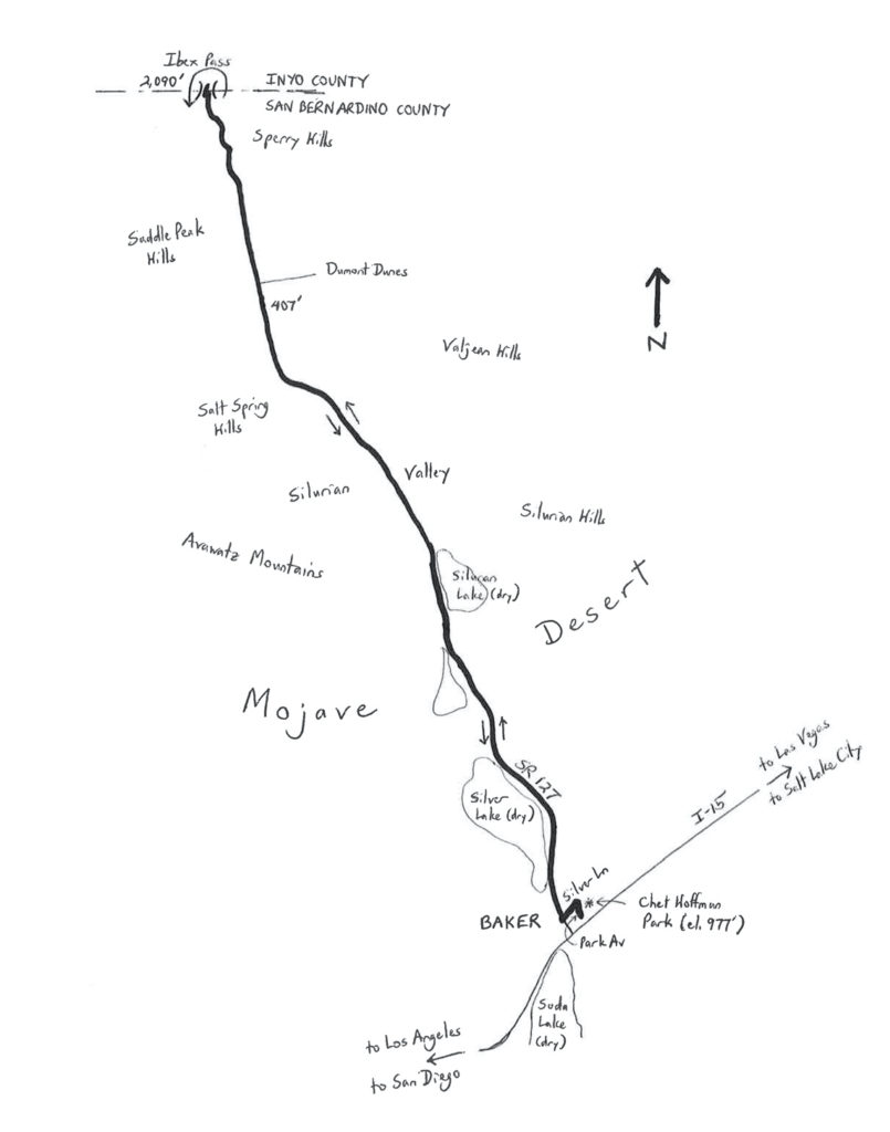
The Mojave Desert Death (Valley) Ride is 80.9 miles in length. Paved roads across the Mojave Desert are sparse, such that a loop ride would be hundreds of miles long. The only option for a day ride is an out-and-back course. I once rode this route as part of an 80-mile, point-to-point road race across the desert. A point-to-point ride is an option for riders who can arrange a pickup at the destination. This ride assumes that you do not have a pickup, though, and will need to return to the origin. Be aware that the Mojave Desert is subject to extreme temperatures that can exceed 120 degrees during the summer. The ride is probably best done during the winter, late autumn, or early spring. Whatever the temperature, the desert is arid and dry – bring plenty of fluids, as there are no facilities (and no easily-accessible water) along the route. Start at Chet Hoffman Park in Baker, from the intersection of Park Avenue and Hillview Drive. To get to the park, exit I-15 at State Route (SR) 127, also known as Kelbaker Road (and as Death Valley Road). Turn right on Kelbaker, and then turn right onto Baker Boulevard. Turn left onto Park Avenue; look for the park on the right.
Head north on Park, and then turn left onto Silver Lane. At the end of Silver, make a hard right onto SR 127, also referred to as Death Valley Road, and head north. Just one mile into the ride, you are already outside of town, aiming for the vast expanses of the Mojave. The stretch of SR 127 that you are about to ride is listed as “scenic highway-eligible” by the California Department of Transportation (meaning that it has not yet been officially designated). To your left, to the north of Baker, is the dry bed of Silver Lake. Silver Lake, along with Soda Lake, which is farther to the south, were once part of ancient Lake Mojave. The lake fills after rainfall that is heavy enough to cause flooding, the most recent of which occurred in 2005. SR 127 follows the alignment of the aforementioned railroad. Evidence of the old railroad still exists, including remnants of the stations – you can search for artifacts as you ride along. Some of the rails were removed in the 1940s, as there was a need for their metallic content during World War II. If the riding seems easy, it is because SR 127 is gradually downhill, from a starting elevation of 938 feet at Silver Lane, to a low point of 407 feet as you cross the Silurian Valley (note that this is not Death Valley). To your far left are the Avawatz Mountains; to your right are the Silurian Hills. Although venturing off the road is not recommended, the neighboring hills are home to bighorn sheep, desert tortoises, kit foxes, burrowing owls, and even golden eagles, all of whom move through the area. As you move through the area, you may catch sight of the odd marker here and there, such as a shoe tree (i.e., an old, possibly dead tree that has been decorated with old shoes – one of several such trees found in the Mojave).
The low elevation of the ride (407 feet) is at mile 29.9, as you cross the (dry) Amargosa Wash. The southern boundary of Death Valley National Park is to your left, as SR 127 now travels along the edge of the park. Nearby, a well-marked trail leads to the Salt Creek Hills, in which one can find the remains of Ibex Spring, a former mining town that was inhabited until the 1960s. From here, the highway climbs gradually to Dumont Dunes Road (mile 32.9, elevation 488 feet). For those who make it out this far, the Dumont Dunes offer some great off-highway vehicle action. SR 127 then enters the Saddle Peak Hills, and then the Sperry Hills, as part of a 7.5-mile climb to Ibex Pass. The pass is at an elevation of 2,090 feet, at the San Bernardino-Inyo County line. This is the turnaround point, 40.45 miles into the ride. Be sure to soak in the desert aura for a moment before heading back. The return ride begins with a rapid descent into the Silurian Valley. From there, it is a long 30-mile, very gradual climb back to Baker. You will catch sight of the World’s Tallest Thermometer from a long distance out, and can use it as a target. Once on the outskirts of town, turn left onto Silver Lane, followed by a right turn on Park Avenue, to return to Chet Hoffman Park.
Start/finish coordinates: 35.274747oN 116.063228oW
For more rides, see Road Biking Utah (Falcon Guides), written by avid cyclist Wayne Cottrell. Road Biking Utah features descriptions of 40 road bike rides in Utah. The ride lengths range from 14 to 106 miles, and the book’s coverage is statewide: from Wendover to Vernal, and from Bear Lake to St. George to Bluff. Each ride description features information about the suggested start-finish location, length, mileposts, terrain, traffic conditions and, most importantly, sights. The text is rich in detail about each route, including history, folklore, flora, fauna and, of course, scenery.
Wayne Cottrell is a former Utah resident who conducted extensive research while living here – and even after moving – to develop the content for the book.
This would be a great ride. I am not sure if LAPD still sponsors a running relay race “Baker to Vegas”, they use to. I ran in the relay in 1989 as part of the Orange County (California) Marshal’s Office team, what a fun experience. There are great options out in that area for Cycling. Injuries curtailed running career in 1990, this was a blessing as it led to the last 40 years of great cycling.
Stay healthy.