By Wayne Cottrell — The Markagunt Plateau Classic is a 53.2-mile lollipop-shaped loop in southern Utah’s high Color Country. The entire route is at high altitude, with a maximum elevation of over 10,000 feet. The ride is best done during the late spring, summer, and early fall months. There are passages through Cedar Breaks National Monument, Dixie National Forest, one National Scenic Byway (Utah’s Patchwork Parkway), and two Utah Scenic Byways (Cedar Breaks and Markagunt High Plateau). There are quite a few hills to climb, but the practically nonstop scenery makes this a must-do, cannot-miss ride. Please note that portions of the route may be inaccessible between November and April.
 The Markagunt Plateau – Markagunt meaning “highland of trees” in Piute – is an elevated, forested plateau that covers a large area between the I-15 freeway and U.S. Highway 89 in southern Utah. Volcanic activity created the plateau thousands and thousands of years ago; in fact, a lava flow, named the Black Rock Desert, can be seen when looking toward the south from certain vantage points when on the plateau. Mother Nature is at her most dramatic in certain locales on the plateau, creating such remarkable features as Cedar Breaks, Mammoth Cave, Pink Cliffs, and Black Rock Desert.
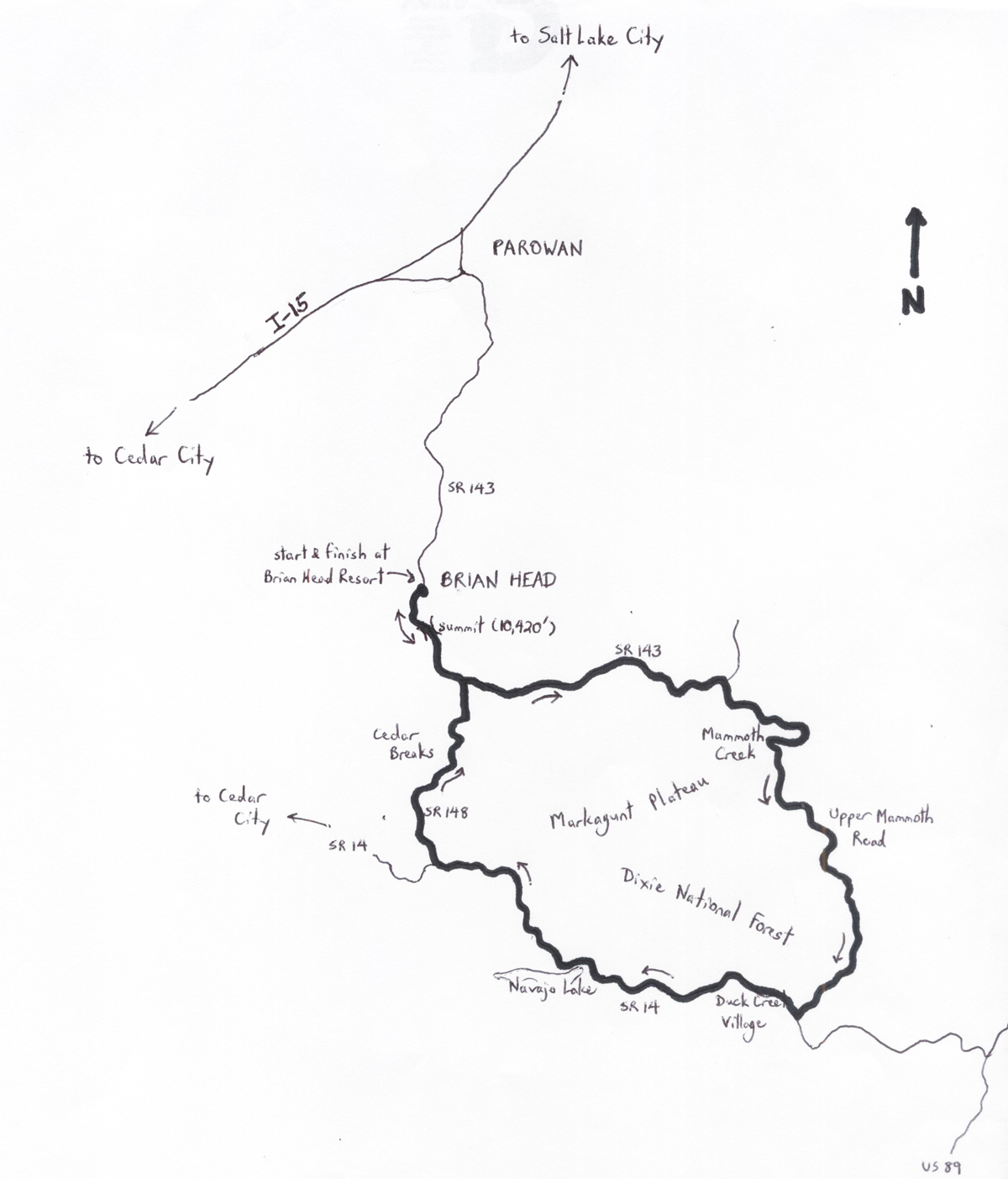
The ride starts and finishes in the town of Brian Head, located at a lofty 9,800 feet (one of the highest in America) in Iron County, in southwestern Utah. The best way to get to Brian Head is to exit I-15 in the city of Parowan, and then head southeast on State Route (SR) 143 – which is Utah’s Patchwork Parkway. The climb to Brian Head is strenuous even for a motor vehicle – thankfully, you will not be riding this portion of SR 143. Brian Head is a small resort town named for nearby Brian Head Peak which, at 11,372 feet, is the highest point in southwestern Utah. Mountain biking events are regularly held here during the summer.
Exit the Brian Head Resort (large parking lot) and turn left onto SR 143. The highway climbs steeply as you exit the town and enter Dixie National Forest. At mile 2.65, the highway crests (at 10,420 feet) – catch your breath, and enter Cedar Breaks National Monument. About one mile into the monument, turn left to continue on SR 143 – you will re-enter the monument later on in the ride. You are still on the Brian Head-Panguitch (Patchwork Parkway) Scenic Byway. After a short climb, to mile 4, the highway begins a long descent along the sloping reaches of the Markagunt. The gradient of the highway is 6% along certain segments. In the distance are Mammoth Ridge and the Paunsagunt Plateau, beyond which is Bryce Canyon (which cannot be seen from here). You will also notice the dense trees of Dixie National Forest. You may be able to catch glimpses of ancient lava flows to your right, although they are mostly obscured. There are numerous pastoral settings along the highway, with meadows, small lakes, and a wide variety of trees. After a short climb, at mile 10.5, SR 143 descends into Black Rock Valley. Enter Garfield County, arguably Utah’s most scenic, at mile 12.3.
At mile 13.5, turn right onto Upper Mammoth Road. There was no street sign when I rode through here a few years ago, but the turn is just beyond a “Mammoth Creek” sign. (The sign is at the entry to a campground). Upper Mammoth is a paved U.S. Forest Service road. The road begins with a brisk descent around a few sharp curves. Enter the community of Mammoth Creek at mile 17.7; take note of the intriguing residential architecture. After crossing the “real” Mammoth Creek, begin a nicely shaded 1.8-mile climb – thus begins a series of scenic “climbs through the pines,” eventually taking the rider to a right turn onto SR 14 at mile 28.4.
You are now on the Markagunt High Plateau Scenic Byway, passing through the community of Duck Creek Village, at 8,507 feet elevation. There is a mini-mart here. Begin to climb at mile 30.3, with Duck Creek babbling on your right. Both sides of the highway are lined with black lava rock through here. At mile 35, look left, between the trees, for glimpses of Navajo Lake. Enter Iron County at mile 37.1; the highway finally crests at mile 38.3, crossing an idyllic meadow, with a dense grove of trees on its perimeter.
Turn right onto SR 148 at mile 41.8; you are now on the Cedar Breaks Scenic Byway. Following about three miles of climbing, the road enters Cedar Breaks National Monument. The Visitors Center is on the left at mile 45.3. Although the Breaks are visible through the trees from the road, a short detour at the Center, to get an unobstructed view, would be worthwhile. Walk out to the scenic view point for a breathtaking vista. The ride out of Cedar Breaks, although hilly and strenuous, is rewarded with spectacular views to the left. Rejoin SR 143 at mile 49.5, as the highway returns to the route’s high point, to the south of Brian Head. After reaching the 10,420 foot summit again, at mile 50.6, and re-entering Brian Head, the highway begins a steep 13% descent into the community. Watch your speed on the descent, and enjoy coasting back into the Brian Head Resort to conclude the ride.
For more rides, see Road Biking Utah (Falcon Guides), written by avid cyclist Wayne Cottrell. Road Biking Utah features descriptions of 40 road bike rides in Utah. The ride lengths range from 14 to 106 miles, and the book’s coverage is statewide: from Wendover to Vernal, and from Bear Lake to St. George to Bluff. Each ride description features information about the suggested start-finish location, length, mileposts, terrain, traffic conditions and, most importantly, sights. The text is rich in detail about each route, including history, folklore, flora, fauna and, of course, scenery.
Wayne Cottrell is a former Utah resident who conducted extensive research while living here – and even after moving – to develop the content for the book.