By Wayne Cottrell — The goal of going from a city’s lowest to its highest elevation, whether on foot or by bike, offers a challenge to those looking for some exercise, or even some serious training. Los Angeles is notable for having the greatest differential between its lowest (sea level) and highest (5,075 feet) points of any of the 50 largest cities in the U.S. The high point is at the peak of Mount Lukens, which is accessible only by truck trail. For a road cyclist, the city’s highest point is in the northeast corner of the Tujunga community, at a tamer elevation of 2,403 feet. Still, cycling from the beach to Beverly Hills to Blanchard Canyon, in Tujunga, is long and challenging enough to suit any fit rider. The cyclist should be warned that the route is quite urban, and they should be equipped with the skills needed to navigate city roads that can be heavy with traffic and controls, and occasionally narrow shoulders. The L.A. Metro Bike Network does not, unfortunately, provide for a seamless connection between the points along this route. There are also a couple of climbs and descents along the way, so the net climbing is much greater than 2,403 feet, totaling over 4,500 feet. In fact, the returning “descent” direction has 1,080 feet of climbing!
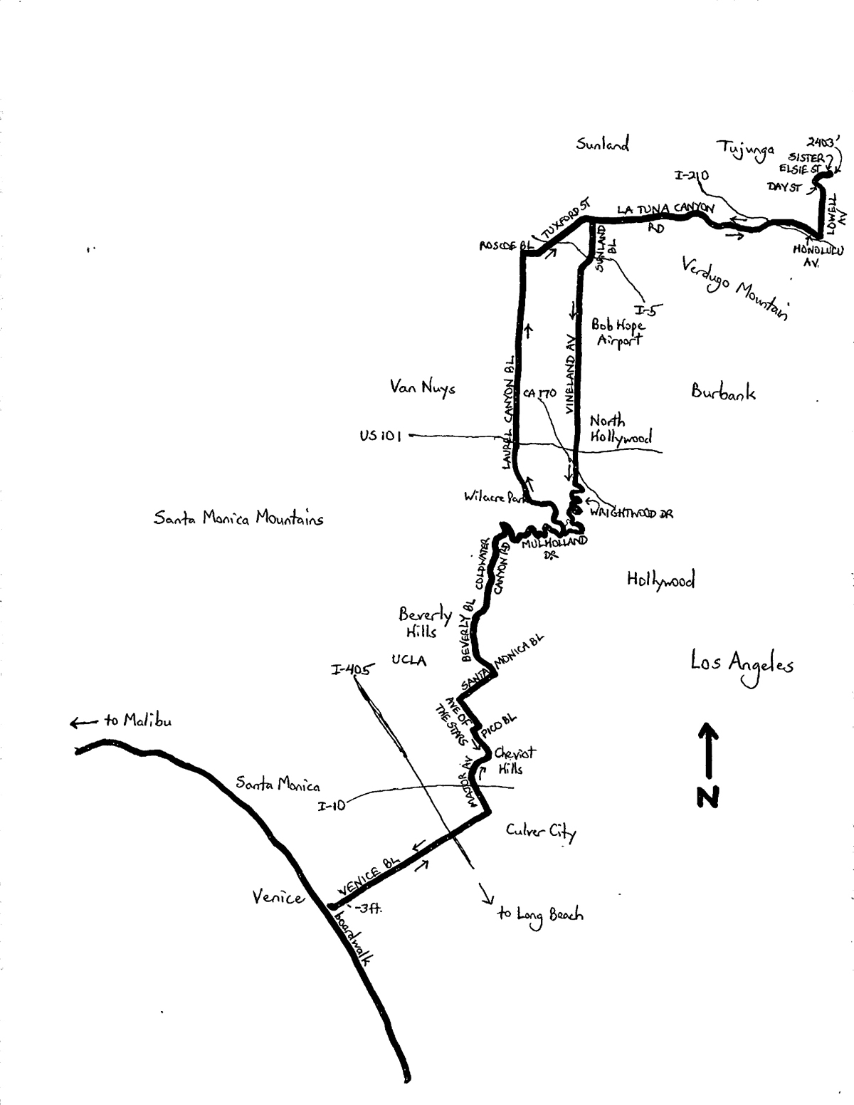
The total out-and-back distance of the ride is 67.0 miles. Start at L.A.’s famous Venice Beach. Parking fees in lots near the beach can be notoriously high — $15 on weekends, as I write this — but free neighborhood parking can be scarce. Wherever you park, be sure to start and finish at the beach on the Venice Boardwalk (bike and footpath). Head east on Venice Boulevard, which is part of the Metro Bike Network, and has a bike lane. The ride begins with an odd effect, with a short climb and then a descent to the ride’s lowest elevation of three feet below sea level, at Dell Avenue (at 0.25 miles). On Venice, there are plenty of traffic signals, and some segments along which the bike lane is sandwiched between street parking, bollards, and the sidewalk — watch for pedestrians and turning traffic. Also, be cautious through the I-405 freeway underpass, which was dark and littered (adjacent homeless encampments) when I rode this. Turn left on Motor Avenue (mile 4.6) and head north — Motor has a bike lane or sharrows and is also on the bike network. After passing through the Palms neighborhood, the scene changes drastically as you enter the posh Cheviot Hills community. The road rolls through here, giving you your first taste of some climbing. Turn right onto Pico Boulevard, which has multiple lanes but no shoulder (definitely not on the bike network) — we stay on this road for just one block, before carefully moving left for a left turn onto Avenue of the Stars (mile 7.25).
Welcome to Century City! The 20th Century Fox Studio is on the left; the ABC Entertainment Center will be on the right. Continue to Santa Monica Boulevard. Turn right onto “Little” Santa Monica, which is akin to a frontage road, to avoid the heavy flow on the main road. I rode this toward the tail end of the Los Angeles Marathon, when the road was closed to traffic, but that occurs just once a year(!). Enter the city of Beverly Hills at mile 8.5. One block beyond the city’s Rodeo Drive (no, you can’t afford to shop here), turn left onto Beverly Drive. In all of its richness, Beverly Hills is predominantly residential, with stately mansions on very large, manicured lots. A tour of the “houses of the stars” can be fascinating — you may see several Hollywood tourist shuttles while riding. Note that from Pico to Van Nuys, where the ride is headed, only the roads in the flatter areas of Beverly Hills are on the Metro Bike Network. Exercise caution at all intersections, particularly at the wide stop sign-controlled one adjacent Will Rogers Memorial Park.
Enjoy pedaling through swanky Beverly Hills. Bear left on Coldwater Canyon Road (mile 10.55) to begin the first serious climbing of the ride. The average grade is 4.7%, which remains steady. The shoulder was damaged in places when I rode this. Make a sharp right onto Mulholland (mile 13.6; elevation 1,179 feet). You are bound to see other cyclists on this road. Mulholland continues to climb at a 3.7% grade, to 1,295 feet, and then mostly descends (winding) to Laurel Canyon Boulevard (mile 15.95; elevation 1,073 feet). The lands bordering Mulholland are part of the Santa Monica Mountains National Recreation Area, and there are fabulous overlooks. Turn left onto Laurel Canyon to descend rapidly from the ridge. Wilacre Park, great for a short mountain bike ride, is on the left at mile 17.3. Enter the vast Van Nuys valley at mile 18.0, with Studio City to the right, and the Silver Triangle to the left. Continue heading north on Laurel Canyon. Anticipate heavier traffic volumes in the valley than on the ridge roads. Laurel Canyon is part of the Metro Bike Network north of Riverside Drive (mile 19.0; elevation 625 feet). Turn right onto Roscoe Boulevard (mile 23.4; elevation 819 feet) and head east. You are still on the Metro Bike Network, although the bike lanes fade where the road is damaged under the I-5 freeway. Continuing to head east, Roscoe becomes Tuxford Street at mile 23.9, and La Tuna Canyon Road at mile 25.15. Riding onto La Tuna marks the beginning of a long climb up the canyon (average grade 3.6%, with steeper segments). Verdugo Mountain is to the right, with a few primitive trailheads. La Tuna Canyon passes under the I-210 freeway at mile 29.95 — there is a popular trailhead here. The road continues to climb on the other side of the freeway to a crest at 1,766 feet (mile 30.8), followed by a fun descent. Turn right onto Honolulu Avenue, and then move left for a turn onto Lowell Avenue.
This marks the start of the final phase of climbing. The average grade is a stiff 7.5% for the next 1.25 miles, including a steeper but short kickup to Foothill Boulevard. There may be a queue of cars at the burger joint on the corner. Lowell straddles the boundary between the cities of Los Angeles and Glendale north of Foothill. At the top, turn left onto Day Street (mile 32.7), for a fast descent into the Tujunga community. The rest is over quickly, though, with a right turn onto Sister Elsie Street. I admittedly had to walk the bike up this road, as the average grade of 15.9% was a bit steep after the climb to get here. Whether you walk or ride up, the street is narrow, so watch for motor vehicles. There is some relief after 0.4 miles, as Sister Elsie levels. The final stretch to the peak is a narrow, paved road in poor condition that leads to a water tank — you may prefer to turn around early and avoid this stretch (elevation, 2,370 feet).
The return route is slightly different from the outbound route. Exercise caution on the descent of Sister Elsie, as it is very steep. There is no stop sign at the bottom, but stop anyway, as the cross street (Day Street) has no stop sign either! Continue to reverse the outbound route to the intersection of La Tuna Canyon Road and Sunland Boulevard (mile 42.2). Turn left on Sunland, which flies over the I-5 freeway, and then bears left to become Vineland Avenue. Vineland heads south, gradually descending, with the Bob Hope (Burbank) Airport to your left. Vineland is on the L.A. Metro Bike Network as far south as Vanowen Street. Continue on Vineland through the vibrant North Hollywood community.
Exercise caution at the six-legged intersection with Camarillo Street and Lankershim Boulevard. Vineland narrows after crossing Ventura Boulevard (mile 48.95; elevation 570 feet), as you begin the climb to Mulholland. (Based on experience, the climb up Laurel Canyon is too narrow and busy for comfortable cycling). Turn right onto Wrightwood Drive, which is a steeper but safer alternative to Laurel Canyon. The road kicks up at an 8.6% grade, increasing to 14.0% after 0.4 miles, and then easing to 6.4% after another 0.2 miles. Watch the street signs, as Wrightwood makes a series of turns during the climb. After the road curves left (mile 49.15), turn right, then left, then left again to stay on Wrightwood. After another climb at 8.2%, Wrightwood reaches Mulholland Drive (elevation 1,175 feet). Turn right — Mulholland climbs slightly, then descends to Laurel Canyon. Continue on the reverse route to Venice Beach from here.
Note that the Coldwater Canyon Road descent can be fast, but the shoulder was uneven and bumpy when I rode this — the pavement is smoother in the middle of the lane, but one must ride at motor vehicle speed to fit into a platoon. (The speed limit is 30 mi/h). This route will be discussed in greater detail in my forthcoming The Best Bike Rides in Los Angeles, Volume 2, which is a continuation of my book Best Bike Rides Los Angeles.
Starting & ending point coordinates: 33.983717oN 118.470953oW
Wayne Cottrell is a former Bay Area and Utah resident, and current southern California resident, who continues to conduct extensive research in these places, and elsewhere, to develop the content for bike books. His books include: Best Bike Rides San Francisco, Best Bike Rides books on Los Angeles and Orange County, Best Easy Bike Rides books on Los Angeles, Orange County, and San Francisco, and Road Biking Utah.