By Wayne Cottrell
La Sal Mountains Loop Challenge
The La Sal Mountains Loop Challenge is a challenging-but-rewarding 63.6-mile tour of the mountains east and southeast of Moab. The ride starts and finishes in Moab, and makes a clockwise loop along the scenic La Sal Mountains Loop. This is a popular loop drive for touring motorists, although competition from nearby Arches and Canyonlands National Parks, and Dead Horse Point State Park, keeps traffic volumes dispersed and low. The loop is ridden in the annual Moab Gran Fondo, which is held during the first weekend in May. The fastest riders complete the loop in under three hours! The challenge begins in Moab which, with a population of 5,130 in 2013, is the seat of Grand County, home base for the aforementioned parks, the launching spot for numerous recreational opportunities, and the largest city for 100 miles in any direction. The city is thought to be named for the biblical city of Moab, but Moabites were described as incestuous and idolaters. Past attempts to change the name of the city failed; however, there is evidence that the name is actually derived from the Paiute word “moapa,” which means mosquito. Start the ride at Moab Rotary Park, located at 680 East Mill Creek Dr. From the parking lot, turn left and head west on Mill Creek.
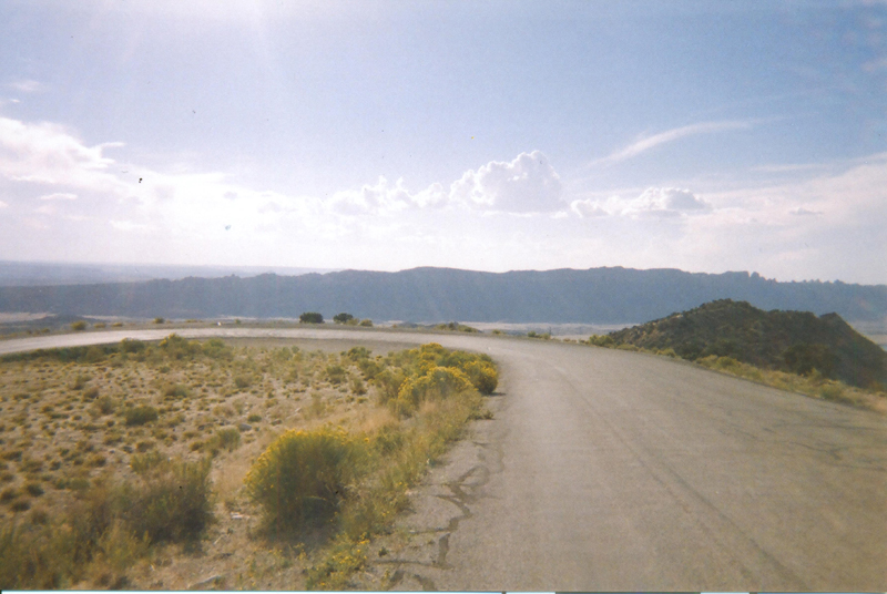
Turn right onto 4th Street (400 East) at the stop sign, and head north. The Apache Motel at 159 South 400 East is on the National Register of Historic Places. Turn left onto 100 North (stop sign), and then right onto Main Street at the traffic signal, as you head right into the heart of Moab. Be sure to stock up on nourishment for the trip while in town. Note that Main Street can be busy, especially during the spring and summer, when you would swear that there are far more than 5,000 people in town. You are on Main Street, which is U.S. 191, as you head north and out of town. Just before the highway crosses the Colorado River, turn right onto State Route (SR) 128, 3.8 miles into the ride. This is the low point of the route (elevation 3,985 feet). Enter the Colorado Riverway Recreation Area – note the “Watch for Bicycles Next 10 Miles” sign. The highway is a scenic byway that parallels the river, winding its way between sheer canyon walls and dramatic scenery. There are numerous recreational pullouts along the way, including Oak Grove, Big Bend, and Takeout Beach, and others. Many of these have lavatories. Please note that the sight distance is poor on the many right-hand bends along this highway. Negro Bill Canyon is at mile 6.9 of the ride, named for William Granstaff, a cowboy who was actually of mixed race. A derogatory form of “negro” was used until the 1960s. The canyon was the site of 1979’s Sagebrush Rebellion. The ride’s first elevation change comes at mile 14.3, with a short uphill and downhill; at mile 17.6, SR 128 veers away from the river, and begins to roll.
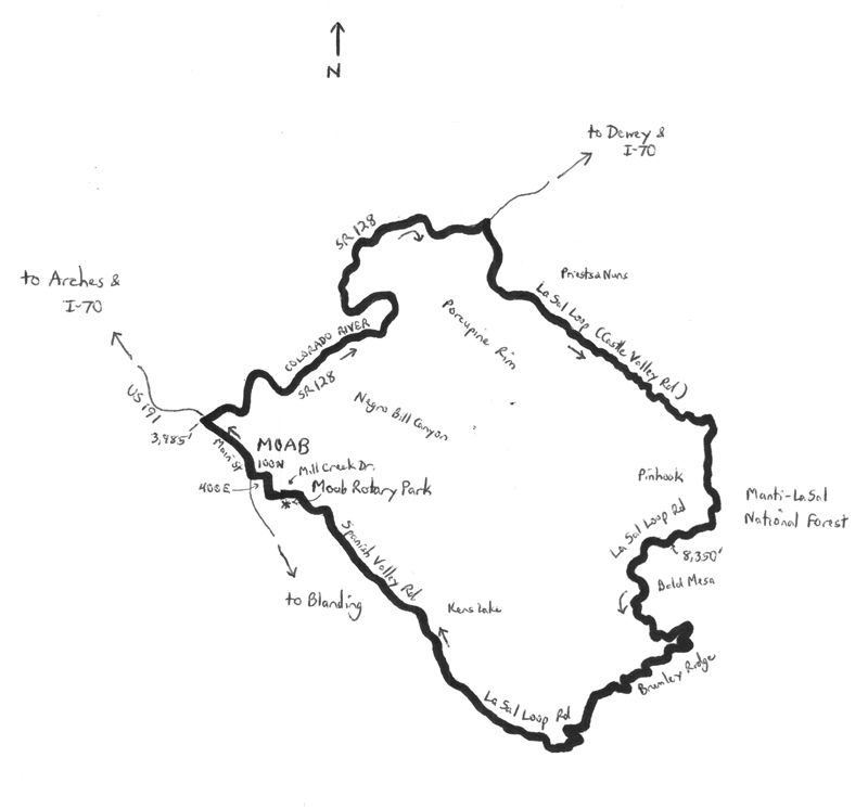 At mile 19.6, turn right onto La Sal Loop Road. There is a large map display on the right, just after the turn. Get your bearings, and then find your climbing legs, as this is where you enter the mountains. The gradient from here is intermittently steep. The La Sal Mountains are Utah’s second-highest mountain range (the Uintas are the highest); Mount Peale is the tallest peak, at 12,721 feet above sea level. Enter Castle Valley at mile 21.2, noting the vivid red landscape, and the fascinating rock formations to your left. These include Priests and Nuns, Castle Rock, and the imposing Parriott Mesa. The road bypasses the town of Castle Valley, which is to your right. The road continues to climb steadily through the valley, as you pass 5,000 feet, and then 6,000 feet. The adjacent foliage gets denser, and the road gets narrower and rougher, particularly at mile 28.4, after crossing a cattle guard. The long, mostly straight valley road, with the massive Adobe Mesa to your left, starts to twist and turn at mile 29.3. Turn right at mile 30.5 (elevation 6,495 feet) to continue on La Sal Loop Road. After about one-half mile of more climbing, and passing the 7,000-foot mark, the steep drop-off to your right reveals a spectacular vista – you can see Moab from here! Enter Manti-La Sal National Forest at mile 32.3. Down in the valley to your right is the site of Pinhook Battleground. In 1881, this was the scene of a horrific battle between Native Americans and white settlers; a number of lives were lost. The climbing continues, finally reaching the high point of the ride at mile 36.7 (elevation 8,350 feet).
On the way to the top, you will have witnessed the tree-scape transforming from Pinyon pines and junipers to oak and larger pines, along with some whispering Aspens. From the high point, the road is predominantly downhill, with some intermittent breaks in the descent. Use caution when crossing the cattle guard at mile 39.9, as it is awkwardly placed in the middle of a right-hand bend. Another cattle guard, at mile 42.5, is on a steep downhill – use caution here, too. There are a few sharp downhill curves, including a couple of 180-degree bends – be sure to stay to the right. Leave the Manti-La Sal National Forest at mile 48.9. Around mile 50, note how the landscape has gradually changed from the green vegetation of the higher elevations, to the scrubby, sandy desert environment of the lower elevations. Broad vistas are among the descent’s features. Moab is in view at mile 53.3. Where the road bends to the right at mile 55.5, you are now on Spanish Valley Road on the very outskirts of Moab. The return to civilization is evident at mile 57.1, as the once narrow road with no striping now has a centerline! Note the “slick rock” to the right – you may see some mountain bikers plying this terrain. Spanish Valley Road bends to the right at mile 62.3; you have now returned to Mill Creek Drive. Turn left at the stop sign at Sand Flats Road to continue on Mill Creek. Moab Rotary Park is on the left, just down the road. End the ride here.
For more rides, see Road Biking Utah (Falcon Guides), written by avid cyclist Wayne Cottrell. Road Biking Utah features descriptions of 40 road bike rides in Utah. The ride lengths range from 14 to 106 miles, and the book’s coverage is statewide: from Wendover to Vernal, and from Bear Lake to St. George to Bluff. Each ride description features information about the suggested start-finish location, length, mileposts, terrain, traffic conditions and, most importantly, sights. The text is rich in detail about each route, including history, folklore, flora, fauna and, of course, scenery.
Wayne Cottrell is a former Utah resident who conducted extensive research while living here – and even after moving – to develop the content for the book.
[…] road bike. They have built some really beautiful bike lanes here. Hubs wants to climb the La Sal mountains. Eric has climbed it both by mountain bike and road bike. By road bike, I believe he mentioned […]