By Wayne Cottrell — Returning us to the San Francisco Bay Area, Kirker Out to Marsh Creek is a 38.0-mile, clockwise road bike ride in eastern Contra Costa County. There is over 2,500 feet of climbing along the way, broken into three separate climbs. The distance from downtown San Francisco to Clayton Community Park, where the ride stages, is 33 miles. This is just outside of the region covered in my Best Bike Rides San Francisco, but would be in my forthcoming Cycling Centra Contra Costa. The route is long enough to creep into the adjacent, smaller Antioch urban area. The ride begins in Clayton, a little-known city of 11,600 located immediately to the southeast of Concord. Getting there from San Francisco by car is easy: Bay Bridge to I-580 to the CA 24 freeway (through the Caldecott Tunnel). After exiting to I-680 north in Walnut Creek, exit immediately to Ygnacio Valley Road, and head east. Once in Concord, turn right on Clayton Road and enter Clayton. Look for Clayton Community Park on the left, near the eastern limit of the city. By public transportation, ride BART (Bay Area Rapid Transit) to the Concord station. From here, bus transit service is available to Clayton, via Central Costa County Transit Authority´s route 10.
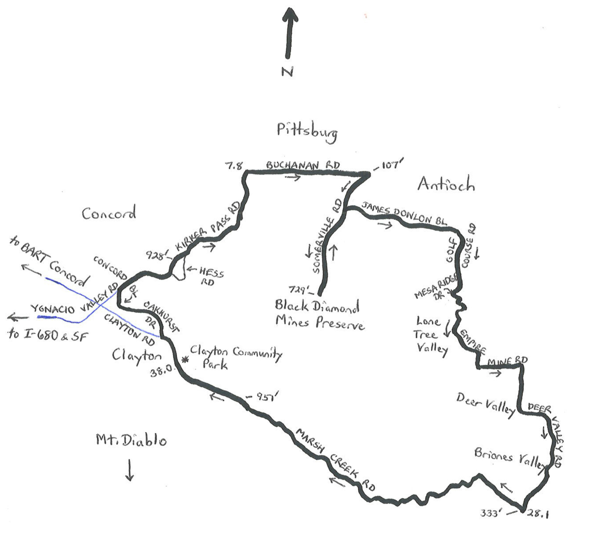
Start the ride by leaving the park and turning right onto Clayton Road, and riding through Clayton. The starting elevation is 549 feet. The city is dominated – as is nearly all of Contra Costa County – by mighty Mount Diablo, which is directly to the south. Turn right on Oakhurst Drive (mile 1.25). Enter the city of Concord at mile 2.45 – you are now on Concord Boulevard. With a year 2020 population of 125,400, Concord is the largest city in the county. Concord is best-known for the 1944 Port Chicago disaster, in which a munitions explosion killed 320 sailors, seafarers and civilians (and also led to a Supreme Court case against “mutinous” black sailors, who subsequently refused to work at the port). The city is also the birthplace of Jazz musician Dave Brubeck (1920-2012). Turn right on Kirker Pass Road at mile 3.0, and begin the route´s first significant climb. To the right, at the base of the climb, is Concord Pavilion, home of the annual Concord Jazz Festival (and numerous other concerts). The road, named after James Kirker, was undergoing a name change review as of this writing. Although Kirker was one of the founding settlers of Contra Costa County and the Concord area during the early 1850s, he was reputedly an Apache scalp hunter. His raids with others on Indigenous tribes produced nearly 500 scalps, according to the records, including women and children – consequently, there is a renaming campaign. Kirker Out!
As for the road, it climbs at an average grade of 7.1% for the next mile, then kicks up to 9.8% for the ensuing one-third mile, after passing Hess Road. Note that Hess is a bypass, as the main road’s shoulders may be uncomfortably narrow for some riders, particularly while rocking and pedaling a bicycle up a nearly 10% grade(!). Hess has even steeper segments, but far fewer motor vehicles. Back on the main road, which peaks at 928 feet, the descent is brisk, entering the city of Pittsburg at mile 7.25. You are now at a lower elevation (243 feet) than you were at the start. Turn right on Buchanan Road (mile 7.8) and head east. Buchanan gradually descends, passing Stoneman Park, which is on the site of Camp Stoneman, a major staging area for the U.S. Army during WWII and the Korean War. Buchanan enters the city of Antioch at mile 10.0, reaching the ride’s lowest elevation (107 feet) at the intersection with Somerville Road (mile 10.6). Turn right on Somerville Road, now heading south and climbing. It is a gradual climb to James Donlon Road, at mile 11.5
At this point, the ride is extended by a 4.45-mile out-and-back on Somerville. The road, climbing at an average grade of about 4%, enters Black Diamond Mines Regional Preserve, and continues to a dead end at a parking lot (elevation 729 feet). The preserve’s name might be misleading, in that no diamonds were ever mined here – the “black diamond” is coal. A total of 400 million tons were produced, starting in 1859. Twelve mines and five towns were located within the Preserve´s present-day boundaries – relics and ruins from these can be found, including a cemetery in which most of the bodies remain unidentified. There is also an extensive network of trails, some steep, that are suitable for hiking, running, orienteering, and mountain biking. After reaching the end lot, return to James Donlon in a thrilling descent. Be watchful of motor vehicles, pedestrians, and other road users. Turn right on James Donlon (mile 15.95) and head east. The city of Antioch is nearly as populous as Concord (115,300), large enough to have its own urban area. Turn right on Golf Course Road (mile 15.0), followed by another right onto Mesa Ridge Drive (mile 16.05). These roads climb gradually. While riding through the mild-mannered Dallas Ranch community, make an abrupt departure from suburbia with a right turn on Empire Mine Road. This is an old country road that was here long before the subdivision. Motor vehicle access to the road was impeded by large rocks when I did this, but the road is otherwise accessible to bicycles. It is lightly-maintained, so watch out for road damage and debris. It also passes through an open range, so cattle could literally be in the road. Empire Mine continues for 3.45 miles, and is net downhill, but there are a few short uphills along the way. There is little to no development out here; you have entered Lone Tree Valley, a rural area marked by ranches, some horticulture, and open space. At the end of Empire Mine (mile 23.75), turn right on Deer Valley Road and head south. Deer Valley is another lightly-traveled, rural road that undulates, climbing gradually, for the next 4.4 miles. Unlike Empire Mine, Deer Valley is accessible to motor vehicles, so be alert to passing motorists.
The final stretch of the ride, beginning at mile 28.1, is on Marsh Creek Road, perhaps the marquee road of the route. You are bound to see other cyclists out here, including elites who use the road for training. Marsh Creek Road winds through Marsh Creek Canyon, gradually ascending from 333 feet, at Deer Valley, to the highest elevation of the ride, 951 feet, at mile 36.15. There are numerous elevation changes along the way, but all of the climbing is gradual. Other than a small community (Clayton Palms), dog training facility, rehabilitation center, and isolated residences, there is little development out here. From the peak elevation point, it is another 1.85`miles, all downhill, to the finish at Clayton Community Park.
Starting & ending point coordinates: 37.928897oN 121.919139oW