One of the most popular routes to ride in Marin County, California is known as the Alpine Dam Loop. I can’t tell you how many times I’ve done the loop, but I remember one 4th of July ride over twenty years ago clearly, as if it just happened yesterday, because for me, it was absolutely the most perfect day I have ever had on the bike.
Of course, these were the days before smart phones were ubiquitous and people didn’t generally stuff film cameras in their jersey pockets, so there are no pictures. One had to rely on their actual brains to create memories.
From my apartment on Nob Hill, I left fairly early that morning and headed towards the Presidio and the Golden Gate Bridge via Polk Street and through Cow Hollow, as was my typical route to get to the Bridge. It was a typical San Francisco morning, foggy and grey. Since there was a bit of a chill in the air, I was wearing arm warmers and knee warmers, as well as a light jacket over my bibs, jersey and base layer.
As I rode across the Bridge, you could start to see the sun peeking through to the east as the fog began to burn off over the Bay and the City, but it was still rather foggy west of the Gate. As I dropped down Alexander Avenue into Sausalito the sun finally came out, so once I hit Bridgeway at the bottom, I stopped to take off my jacket and stuff it into a jersey pocket.
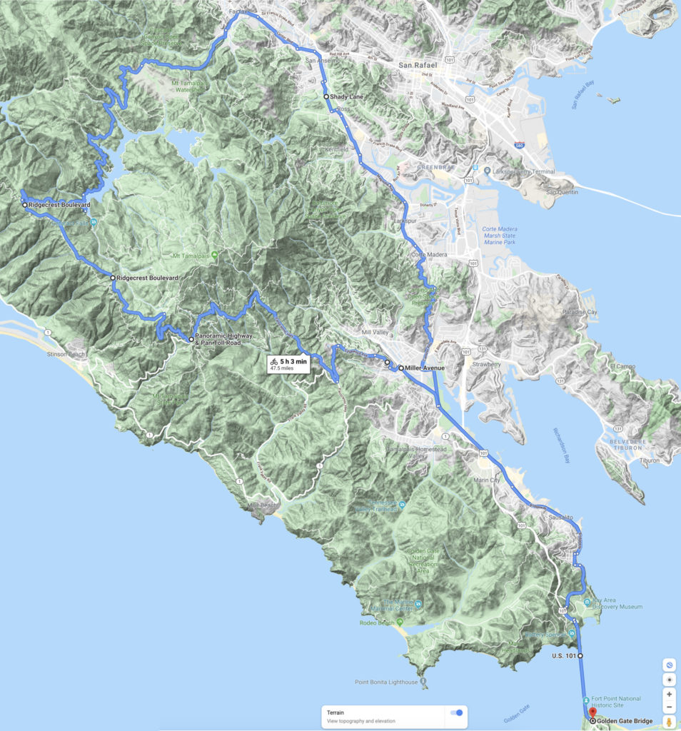
After a quick stop at A Bicycle Odyssey (the shop at which I worked at the time) to grab a Clif Bar, I continued north along Bridgeway to the Mill Valley Bike Path, and then to East Blithedale Avenue at the other end. A quick jog left on East Blithedale and right onto Camino Alto took me up and over the hill into Corte Madera.
At this point the sun had been out long enough that it was warming up, so I stripped off my arm and knee warmers, and then rode north along Magnolia Avenue to where it changed into College Avenue near the College of Marin in Kentfield, then along Kent Avenue onto Ross Common, a quick left on Lagunitas, and right on Shady Lane into San Anselmo.
From there, I continued north along San Anselmo Avenue and Center Avenue into Fairfax, and then left up Bolinas-Fairfax Road. By this time, the sun was high in the sky, and it was baking on the exposed climb of Pine Mountain, but once the climb was crested, a rapid descent under the redwood canopy followed down to Alpine Dam.
Once across the Dam, I kept climbing Bolinas-Fairfax Road up the backside of Mount Tamalpais, but I was now being “rained” on by the condensation and dew dripping off the trees, until I finally crested at the intersection of Bolinas-Fairfax and Ridgecrest Boulevard.
As I rode along Ridgecrest, the fog was so socked in that I could barely see 10 feet in front of me, and I definitely could not see Highway 1 or Bolinas at the bottom of the mountain to the west. As I came over the top of each of the Seven Sisters on Ridgecrest, I would break out of the fog and into the sun, with a blanket of pure white below me on all sides, before dropping back into the soup until I reached the next roller in line.
Ridgecrest curves back east around to the front side of Mount Tamalpais, which was protected from the fog by mountain, which allowed me to drop down Pan Toll Road to the Panoramic Highway, and then back into Mill Valley via Sequoia Valley Road and Edgewood Avenue at full-speed, then along Miller Avenue back to the Mill Valley Bike Path back to Sausalito to begin the climb back up Alexander Avenue to the Bridge.
Once back on the Golden Gate Bridge going south back into the City the fog coming through the Gate was literally so thick that it was rolling like a wave over the cables on the Bridge, a fact that made me glad that I stopped on the north end to put my warmers and jacket back on.
I then dropped back down through the Presidio, back into Cow Hollow, to Polk Street, and home on Nob Hill where a lovely hot shower was waiting for me. From my apartment, it was about a 58 mile round-trip ride. Starting from the parking lot on the south side of the Golden Gate Bridge it is 47.5 miles with about 3,500 feet of total climbing; a challenging ride, but not a ridiculously difficult one.