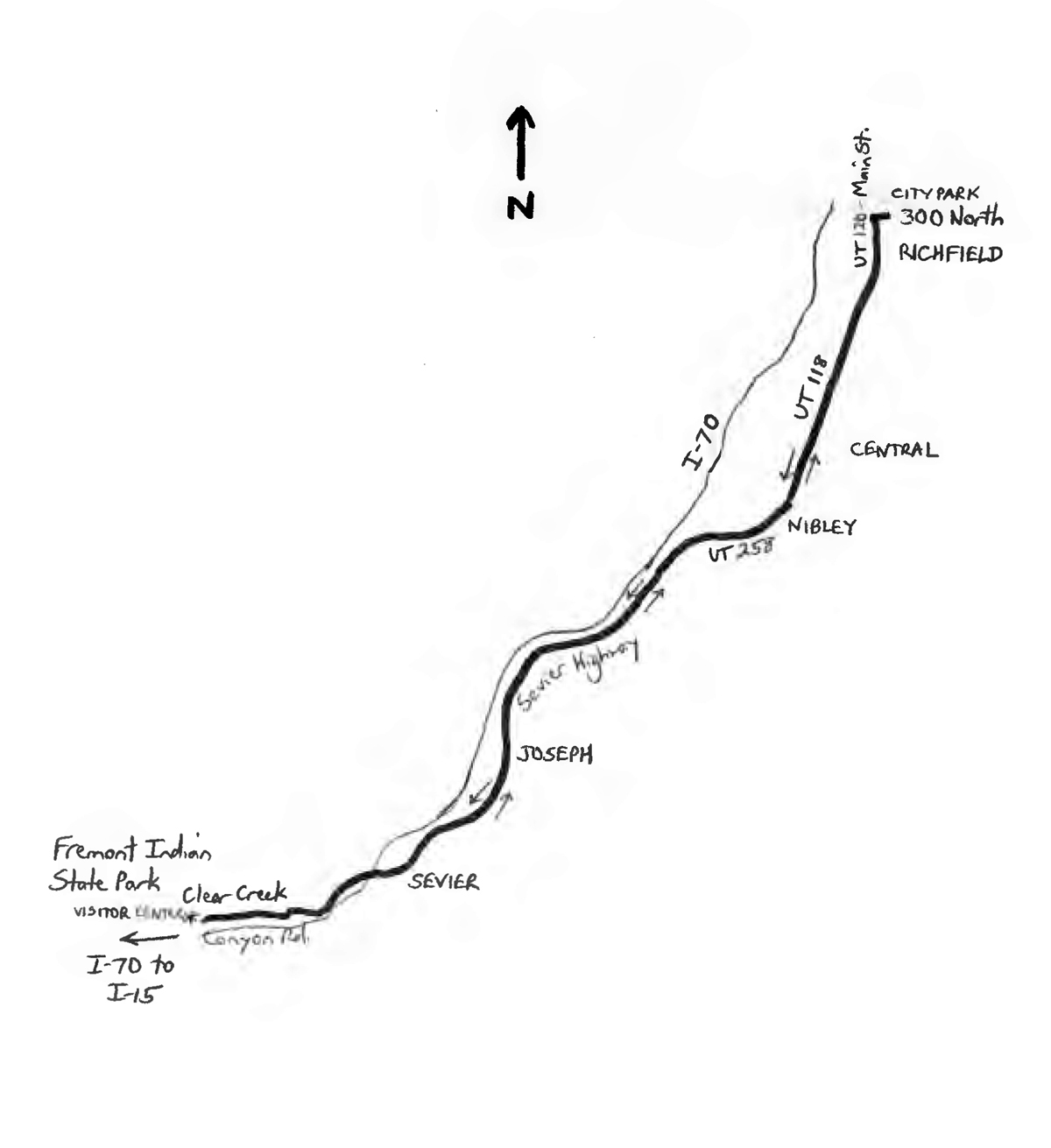
By Wayne Cottrell — The Fremont Indian Country Cruise is a 45.4-mile out-and-back ride over flat, false-flat, and rolling terrain between the city of Richfield, Utah, and Fremont Indian State Park. The park is located southwest of Richfield, in Utah’s “Panoramaland” country, in south central Utah, west of the Sevier River. Start and finish the ride at Richfield City Park, located adjacent 300 North and Main Street. Richfield had a population of 7,610 in 2016, up slightly from its 2010 population. Despite its comparatively small size, Richfield is the largest city for about 100 miles in any direction. Hence, it is the commercial, shopping and entertainment center for an expansive, mostly rural population. The city’s influence region includes Sevier County, and portions of Millard, Piute, and Sanpete Counties. Turn left and head south on Main Street, which is Utah Route 120 (UT 120). You may encounter a small amount of city hustle and bustle, here in the center of Richfield. Some of the buildings that you see, along the way, are on the National Register of Historic Places (NRHP), including the Sevier County Courthouse (between 300 North and 200 North).
A description of this ride appears in the author’s Road Biking Utah, which was published in 2010. What has changed since then? Well, the towns, roads and scenery are the same. The populations of Richfield and the surrounding communities have grown only marginally. The economy is still heavily agrarian, with some industry. Also, the region holds a rich tradition in ancient Native-American cultures, particularly that of the Fremonts, who inhabited the area between about 2500 B.C. and 1500, with its most culturally-distinguishing period occurring between 400 and 1300. In fact, the ride’s route takes you from Richfield, through several neighboring communities, and into Fremont Indian State Park, before turning around for the return ride. There are no major climbs, as the elevation ranges from 5,354 feet in Richfield to 5,709 feet along Clear Creek in Fremont Indian State Park.
At the southern edge of Richfield, keep straight onto UT 118 (mile 3.5). You are bound to see plenty of grazing horses and cattle in the pastoral setting. Continue straight onto UT 258 at mile 6.4. The highway curves to the right, passing along the northern edge of Nibley, a small community that is not to be confused with the larger Nibley in Cache County. As UT 258 heads west, enter the town of Elsinore, which had a population of 845 in 2012. Elsinore is famous for the efforts of then-10-year-old Jason Hardman who, in 1980, petitioned the town’s mayor to set up a library. Space was allocated in the town’s public school, and Hardman became the youngest librarian in the U.S. Within two years, the library had 10,000 books, mostly from donations. UT 258 continues to head west toward the I-70 freeway. At mile 8.3, turn left onto Sevier Highway, which heads southwest-ward, parallel to I-70, to your right, and the Sevier River, to your left. As for the freeway, I-70’s 232-mile stretch through Utah is considered to be one of the most scenic Interstates in the U.S. Richfield is the largest settlement along I-70 in Utah. A large cache of Fremont artifacts were discovered during the freeway’s construction, including the largest known Fremont village. In fact, Fremont Indian State Park, where you are heading, was developed as a consequence of the I-70 excavations. The park opened in 1987.
Sevier Highway enters the town of Joseph at mile 13.7. The population was 346 in 2016, up nearly 30% since 2000. The town was named for Joseph Ford, a local miner, as opposed to the biblical Joseph, or Mormon prophet Joseph Smith. There is a gradual climb at mile 14.8, as you leave Joseph, followed by rolling terrain. Enter Sevier at mile 16.4; this small settlement had a fluctuating population of about 80. The Sevier Ward Church, which is on the NRHP, is along the highway. Cross U.S. Highway 89 at mile 17.8, followed by an I-70 overpass. You are now on Clear Creek Canyon Road, entering an area that is rich in archeological finds. Enter Fremont Indian State Park at mile 19.5. There are numerous trailheads and information displays along the road. Steep cliffs surround you, with I-70 to your left. The cliffs and nearby coves and caves are abundant in Fremont pictographs and petroglyphs. Although you could spend an extensive amount of time exploring the park, the turnaround is the Visitor Center, at mile 22.6. But, before heading back, dismount and check out the exhibits in the Center. The return ride reverses the outbound route.
Starting point coordinates: 38.772544oN 112.084258oW
For more rides, see Road Biking Utah (Falcon Guides), written by avid cyclist Wayne Cottrell. Road Biking Utah features descriptions of 40 road bike rides in Utah. The ride lengths range from 14 to 106 miles, and the book’s coverage is statewide: from Wendover to Vernal, and from Bear Lake to St. George to Bluff. Each ride description features information about the suggested start-finish location, length, mileposts, terrain, traffic conditions and, most importantly, sights. The text is rich in detail about each route, including history, folklore, flora, fauna and, of course, scenery.
Wayne Cottrell is a former Utah resident who conducted extensive research while living here – and even after moving – to develop the content for the book.