By Wayne Cottrell — Four Corners Circle is a 77.2-mile clockwise road loop in extreme southeastern Utah. But, as the title suggests, the road ventures briefly into three other States: Colorado, New Mexico & Arizona. This is the only spot in the U.S. where one can visit four different States in one reasonably short trip. Most of the ride is effectively within the boundaries of the Navajo Nation. In fact, the Four Corners Monument, which the ride visits, is a Navajo Tribal Park. The terrain is rolling, with no major climbs or descents. The elevation range is about 1,000 feet, though, from 4,423 feet in Montezuma Creek to 5,364 feet in Red Mesa. The Navajo Nation occupies 27,425 square miles in a region that spans northeastern Arizona, southeastern Utah, and northwestern New Mexico. Although the Nation was established by the Treaty of 1868, the Utah portion was not fully appended until 1933, some 28 years after President Theodore Roosevelt had officially approved of the additional lands. The Navajo Nation is home to about 175,000 Native-Americans, and is semi-autonomous, in that the U.S. retains power over all executive decisions. While tourism has boosted the economy, oil fields have been the Nation’s primary economic engine (and, earlier, uranium mining).
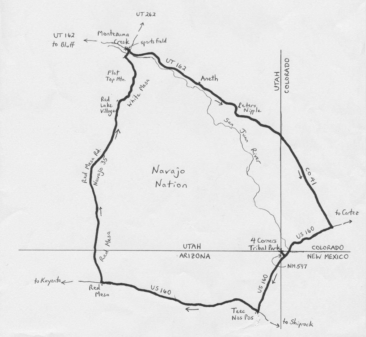
Start the ride in the community of Montezuma Creek, located on Utah State Highway (UT) 162. Montezuma Creek had a population of just over 500 in 2000 (more recent data are not available), and is located 14 miles east of Bluff. The closest major city is Albuquerque, New Mexico, 270 miles to the southeast. Salt Lake City, Utah and Phoenix, Arizona are each equidistant, at 345 miles away. From Montezuma Creek’s sport fields and swimming pool (closed), located on Trading Post Road (UT 162), head east on UT 162. Note that the resident populations of the communities through which the route passes are at least 95% Native-American, so be prepared for immersion in local culture. At Center Street, turn right, followed by a left onto Main Street, to continue heading east on UT 162. The San Juan River and adjacent bluffs are a constant presence, to your right. The next settlement, Aneth (population 600 in 2000), is considered to be a Navajo Nation gateway community. Aneth was first settled by non-Mormon whites, however, in the late 1870s, who would later move away after several years of crop failures.
The San Juan River veers away from the highway as you head eastward from Aneth. Peters Nipple is on the left as you cross Rockwell Flat. Enter Colorado at mile 17.4; you are now on Colorado State Highway (CO) 41. The State line also marks the boundary of the Navajo Nation, as you enter the Ute Mountain Ute reservation. While the latter covers a sizeable region in southwestern Colorado and northeastern New Mexico, its population is dwarfed by that of the Navajo Nation, which has about 100 times as many residents. CO 41 ends at U.S. Highway 160, at mile 26.7; turn right here and head southwest. After crossing the San Juan River, US 160 enters New Mexico for a short stretch. Look for New Mexico State Highway (NM) 597 at mile 33.3. Signs indicate that this is the way to Four Corners. This is a short out-and-back segment, just 0.9 miles total, which is well worth the diversion. Enter Four Corners Navajo Tribal Park at the end of the highway; there is a nominal fee to access Four Corners Monument. Four Corners is at an elevation of exactly 5,000 feet. The requisite action is to stand on the monument, and take a selfie with at least one part of you or your bicycle in each of the four States! Although many visitors are “underwhelmed” by the experience, the monument’s inscription, having to do with four States “meeting in freedom,” is actually quite inspiring.
Exit Four Corners on NM 597, and then turn right to continue heading southwest on US 160. Enter Arizona – note that the Navajo Nation observes daylight savings time, unlike the rest of Arizona. The highway turns right at mile 40.0, in the town of Teec Nos Pos (elevation 5,210 feet). The town’s name means “cottonwoods in a circle,” as opposed to anything else, and is the largest settlement along the route (population 730 in 2010). As this is approximately the midpoint of the ride, this may be a fine place to refresh and replenish. Continue heading westward on US 160, across the often reddish landscape. In fact, at mile 55.3, in the community of Red Mesa (elevation 5,364 feet), turn right onto Red Mesa Road. You are now heading north, with Red Mesa (the geological formation) to your right. The road is also designated as Navajo Route 35. The prevailing direction is downhill, as you will gradually lose 1,000 feet over the next 22 miles. Keep straight at Red Mesa West Road. The road travels between White Mesa on the right and sand dunes on the left, as you continue heading north. The road veers to the right in the community of Red Lake Village, with White Top Mountain off to your right, and Flat Top Mountain to the left. After making a long, gradual curve to the left, Red Mesa Road ends at a T-intersection; turn right onto Center Street, now heading northeast. After crossing the San Juan River, enter Montezuma Creek. Turn left onto Trading Post Road (UT 162), and return to the sports field to conclude the ride. Note that the most neutral attire for the ride would be gold and yellow, as at least one of these colors is featured in two of the flags of the States through which the route passes, as well as the flag of the Navajo Nation.
GPS coordinates (Montezuma Creek sports field): 37.265000oN 109.309000oW
For more rides, see Road Biking Utah (Falcon Guides), written by avid cyclist Wayne Cottrell. Road Biking Utah features descriptions of 40 road bike rides in Utah. The ride lengths range from 14 to 106 miles, and the book’s coverage is statewide: from Wendover to Vernal, and from Bear Lake to St. George to Bluff. Each ride description features information about the suggested start-finish location, length, mileposts, terrain, traffic conditions and, most importantly, sights. The text is rich in detail about each route, including history, folklore, flora, fauna and, of course, scenery.
Wayne Cottrell is a former Utah resident who conducted extensive research while living here – and even after moving – to develop the content for the book.
Claim on only four state ride in that distance doesn’t hold water
There is one near the PA, WV, VI, and Maryland near Hancock that is as short and allows 4 states to be visited. And near the PA, DE,NJ and Maryland boarders it can be accomplished as well. Look out for the cicadas though.