
By Lou Melini
The starting point and timing (mid April of 2015) of this bike tour around Moab was chosen to coincide with a “celebration of life” for Arlo Tejada. Arlo battled cancer for several years. He is the son of Jose Tejada and Liz Ford, old friends of ours from the days I assisted with the Moab bicycle stage races held from 1985-1990. Jose, along with Rim Cyclery founders Bill and Robin Groff, initiated the cycling scene in Moab with the 3-stage “Moab Stage Race”. Jose currently owns Sherrie Griffith River Expeditions. Arlo worked as the marketing director for Jose but also guided some river trips; his last for the Bill Gates’ family. Julie and I left our car at Jose’s house for our own celebration of life, a 6-day bicycle tour starting and ending in Moab, Utah.
The plan was to ride to Monticello on day one then to Natural Bridges National Monument on day 2. That was the plan, but like some plans changes are necessary. The first day went well. Julie struggled a bit on the one long climb before Monticello, but overall did well. We stopped at the grocery store to find it closed. We were briefly puzzled until we realized “It’s Sunday!” The emergency dinner we keep became dinner at the Westerner RV Park on the south end of town, one of 2 RV parks in town. It looked cleaner than the RV Park at the north end of town. It was nice but the bathroom needed a serious cleaning/rebuilding. On day 2 we rode into Blanding to pick up supplies for the next 3 nights, 2 in Natural Bridges and one night at Hog Springs rest stop located 33 miles south of Hanksville.
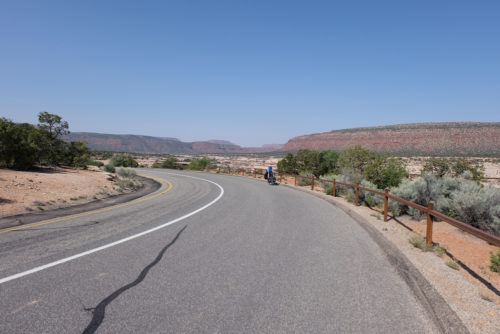
The weather became hot as we left Blanding but we had “only” 35 miles to ride with “only” a 300-foot elevation change between Blanding and Natural Bridges National Monument, a stretch of road we have not previously been on. About 5 miles outside of town we quickly descended for over 2 miles. This wasn’t good. After a 2.5 mile 8% climb, we descended and again climbed for 2.5 miles. A third steep descent really had me concerned. Julie is not built for climbing but she usually does well on our tours but today would really challenge her. After 2 miles on this third climb she was lagging so I strapped her front panniers to my bike. At mile six of the climb she started walking and had difficulty drinking. I stuck out my thumb to try to get her a ride to no avail, though one couple provided us with 2 liters of water. After a quarter mile of walking Julie decided to stop when we saw a shaded shelf of rock just off the road. I obtained another 3 liters from a young couple for our impromptu camp, 12 miles from Natural Bridges National Monument.
Julie fully recovered for our ride to Natural Bridges the next morning. We planned to obtain a campsite and spend the day there. At 9:50 AM we were 20 minutes late for the last of 13 campsites though there is an overflow campground without water 3 miles outside of Natural Bridges. We now had a dilemma. If we stayed at Natural Bridges we would have 60 miles to ride to Hog Springs the next day, our next known source of water. Given what happened after Blanding, I was unsure of how well Julie would handle 60 miles, a normally easy day for her. In previous years, we could have stopped at Hite Marina and Campground but at the time of our departure the website said that no services were available so we were unsure of water availability. (Note: This section of our ride is part of the Western Express trail mapped by the Adventure Cycling Association (ACA). I contacted the ACA after our ride, and cartographer, Nathan Taylor, contacted the National Park Service. Water is now available at the ranger station at Hite.)
With a lot of back-and-forth discussion, we made a decision to ride the Natural Bridges loop road, fill up with 8 liters of water, and move on about 20 miles down the road to Fry Canyon. The senior ranger at Natural Bridges informed us that there was a high likelihood of pools of water just before the bridge at Fry Canyon. That was encouraging. Junior ranger remarked that the last time he was there, one pool was the size of an Olympic swimming pool. Upon further questioning, he admitted his last time to Fry Canyon was 2 years ago, not so encouraging. We had a good filter so we went the 20 miles.
It turned out that my concerns about Julie’s status were not necessary. Arriving at the bridge at Fry Canyon was a quick, mostly downhill ride. Finding shade was a problem so we set up a temporary camp under the bridge, cooking dinner and drinking our stash of good water. The pool of water mentioned by the rangers was the size of a small bathtub and brackish. As the weather cooled near evening we set up our tent on a small patch of sand, pumped enough water for breakfast and moved on the next day to Hog Springs.
<!–nextpage–>
After the heat of the past 2 days we were relieved to have overcast skies on our 4th day of riding. We had mostly downhill terrain to the Colorado River, with the last 2 miles at a 10% grade. We had passed Hite with no signs indicating that it was shut down. Shortly after crossing the Colorado River we encountered a 2-mile 10% climb followed by a relatively flat ride to Hog Spring picnic area. With ample lunch, full water bottles pumped water from the very clean year-round spring and Julie feeling well, we pushed on to Hanksville, a relatively flat 33 miles. Despite her physical and mental breakdown 2 days ago, Julie did well on today’s 68-mile ride.
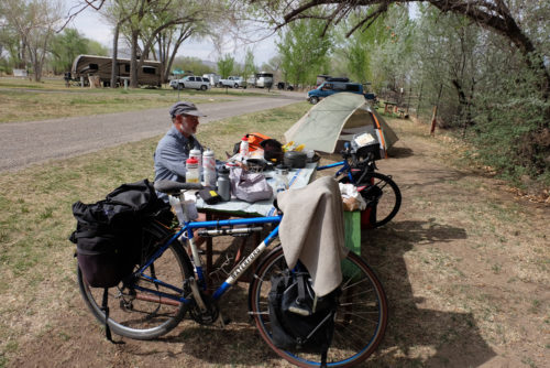
If you have ever been to Hanksville, you will know what I mean when I say it is not a commercial hotbed. It does have an “oasis” for the traveling cyclist, DJ’s Grill and Campground. For us it was paradise. It had fantastically clean bathrooms, hot showers that caused me concern when Julie luxuriated in one for a very long time, and a grassy tent area that would make the groundskeepers for an English Premier League soccer club envious.
As I prepared dinner, I realized that my canister stove that lost the top screw shooting a single large flame in the air. Julie ran away thinking the stove was going to blow up as I replaced it with one of my spare bike bolts. Fortunately, MSR stoves are very simple to operate and fix. After dinner we had ice cream in the restaurant for dessert, at a total bargain-level cost of $20 for camping and dessert.
We shared the tenting area with a cyclist from the U.K. doing his 2nd 6-month ride in America. His plan was to ride the 124 miles to Blanding. I warned him about the website posting at Hite.
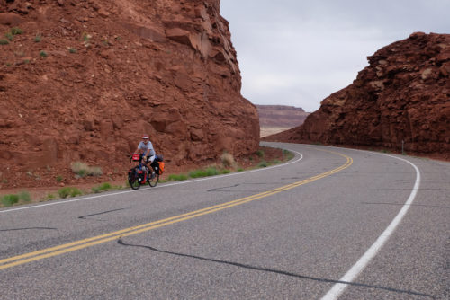
Our final 2 days were again hot, but not oppressive. On day 5 of our ride, we stayed at the Shady Oaks RV Park in Green River, a nearly fraudulent name. Otherwise, it was a pleasant campground. Our last day saw us arrive in Moab. We rode on an 8-foot shoulder on I-70 out of Green River, where I found a total of $1.57 in coins scattered over a 50-yard stretch of road. The road to Moab (route 191/163) was a mix of narrow one-foot shoulder space in some areas and wide 6-foot widths in others. Traffic was heavy and fast. On the narrow sections of the road there were turnouts approximately every mile, the only place Julie and I dared change positions. Except for this section of our tour, traffic was sparse and polite. Our time on state road 95 was relatively devoid of traffic.
Despite the problem of our second day of riding, the trip went well. We would do the trip again with a couple of changes. I think the clockwise direction we traveled is better than going counter-clockwise for several reasons. As we drove out of Moab, I noted the complete lack of shoulder going north out of Moab in a few areas. Also one would avoid the long steady uphill from Hite to Natural Bridges National Monument.
After our experience with the steep climbs leaving Blanding, we would want to camp in Blanding, taking on the climbs in the morning and camp at Natural Bridges. Staying in the remote campground of Natural Bridges would be suitable, but we would cook our dinner at the Visitor Center picnic tables to avoid the 3-mile back-and-forth ride to fetch water. With the now availability of water at Hite, we would consider camping there. However with the amount of downhill, the 89-mile ride from Natural Bridges to Hanksville is a definite possibility for a relatively fit cyclist.
The Moab-to Moab loop (or whichever city you choose to start from) is one of 3 loop tours one can enjoy in Southern Utah that take you through or very near all 5 of Utah’s National Parks. The 3 loops include the Adventure Cycling Association Red Cliffs loop with the loop passing through Zion. Julie and rode this loop in the very early 1980’s. In 2007 we rode from Torrey to Torrey, a loop that included stops at Capital Reef and Bryce NP. The Moab-to-Moab loop took us past Arches and Canyonlands National Parks and as mentioned Natural Bridges National Monument. There is also a State Park with camping in Green River. For those without a car there is a new bus service to Price, Green River ($53). Moab, Monticello and Blanding ($80) from Salt Lake City. It is called Elevated Transit and it advertises “plenty of room in our bay storage area for bikes and luggage.”
The Moab to Moab is a very scenic ride. I highly recommend it, but be prepared!