“And…in Colfax County, they tell the apocryphal story of a cowboy cook who, checking his bean pot and finding the beans still hard, exclaimed, ‘Simmer on!’”, Robert Julyan, The Place Names of New Mexico
By Don Scheese — Almanzo 100. Trans Iowa. Dirty Kanza (now Unbound Gravel). Land Run (now The Mid-South). Rebecca’s Private Idaho. Crusher in the Tushar. Grinduro. Gravel Worlds. These are some of the earliest, and most well-known, gravel races in the USA. As gravel racing has become increasingly popular the past decade or so, more and more gravel grinding events are springing up all over the country, and indeed the world.
The Cimarron Challenge, held in late August in northeastern New Mexico, has taken place every year (except for last year during the pandemic) since 2018. It offers two distances, 68 & 78 miles, requiring between 3800-5000’ of elevation gain, and traverses a variety of terrain on Forest Service gravel roads, more primitive jeep roads, and some singletrack. Except for the first couple miles out of Cimarron, the route follows unpaved roads.
The town itself has some fascinating Western history. Founded in 1841, it soon became a principal stop on the Taos branch of the Santa Fe Trail. It was a natural gathering place for merchants, emigrants, ranchers, miners, traders, and eventually, outlaws, and from 1872 to 1882, when it served as the seat of Colfax County, it became known far and wide as the cowboy capital of northern New Mexico. Today you can walk on a path through the town paralleling Highway 64 and see photos and read about some of the most legendary figures of the nineteenth century West, among them Kit Carson, whose ranch, Rayado, is located nearby.
Over the past 15 years I’ve taken part in many different gravel races in several states, and having done 3 Cimarron Challenges (all on the 68-mile route) I can say without hesitation that this gravel ride has become my favorite. It’s beautiful, wild, & well-supported & well-organized. The Cimarron Challenge should be more widely known.
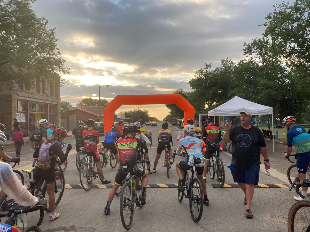
Some 40+ riders line up at 7 am in downtown on August 21, ready to take on the challenge. After a breakfast burrito, coffee and orange juice provided by the most-gracious hosts Colin & Erin of Blue Dragonfly Brewery & Bed & Breakfast, everyone is anxious to start. (There is also a pre-ride pasta dinner the night before, as well as a post-ride feast included as part of one’s entry fee.) Weather conditions are ideal: 60 degrees with a cool northerly breeze. Since temperatures can easily rise into the 90s at this time of year, I’m hoping for a cooler day with the forecast calling for highs in the 80s.
This is a timed event, with every rider having a chip device attached to their bike seatpost. After the official start, we ride at a leisurely pace out of town with a local police escort, then make a left turn on Highway 64 north for a mile or two until we turn left again onto what becomes unpaved road for the next 60 miles. The route crosses private land grant property, areas of the Carson National Forest, as well as the turf of the Philmont Scout Ranch, which is headquartered nearby. (Each summer the Scout Ranch hosts some 20,000 Boy Scouts who camp & hike on the expansive property.)
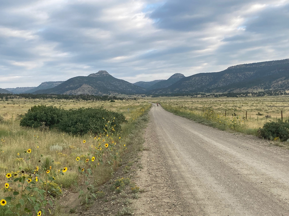
The route gradually ascends through pinyon-juniper forest, from 6400’ in Cimarron to a high point of 8600’ (over 9000’ at Windy Gap if doing the longer route). The first 30 miles or so climb up and out of Cerrososo Canyon, after the Spanish word ‘cerro,’ which means hills, and indeed there are plenty of them as we wend our way on relatively good hard-packed gravel through rimrock-lined defiles. Aside from a few of the race’s volunteers driving to their respective posts at several different aid stations, there is virtually no vehicle traffic—one of the many pleasures of gravel grinding, especially in sparsely populated northeastern New Mexico. Every now and then there is an 8-10% short punchy climb, and as one of the slower riders I quickly lose sight of the real racers participating in the event. No matter: I love gravel riding for the solitude and wildness and am better able to appreciate the beauty and quiet of my surroundings with no other riders around to distract me.
A local resident told me that Cimarron has received 10 inches of rain since April, and the meadows are greener and lusher than I can ever remember. And the sunflowers! There must be millions of them, head-high, lining and illuminating the roadsides with their bright yellow heads. Various sparrows, juncos, and bluebirds spray from the brush, and occasionally I hear the sharp keeeerrr of a red-tailed hawk patrolling high above in search of prey. Windmills dot the meadows too, and each cattle tank is brimming over with water, proof of a robust monsoon season this summer in northern New Mexico.
At the first rest stop, about Mile 17, I chat with the volunteer staffing the station. He drives truck for the Scout Ranch, ferrying scouts and supplies to various camps and outposts on the sprawling 137,000-acre property. This year has been a banner year for the Philmont, hosting over 26,000 scouts after 2 lean or non-existent years in a row because of last year’s pandemic restrictions and the massive Ute Park Fire the year before. After munching an energy bar, banana, orange slices and fig newtons, I thank him and wish him well, remounting my bike just as the last riders (so I’m told) pull up behind me. I will not see them again until the last aid station some 15 miles from the finish.
Around mile 30 the road descends into Lookout Canyon, where ponderosa pine predominate, and the Culebra Range makes an impressive appearance. Spanning the Colorado-New Mexico border, the Culebra (‘snake’ in Spanish) towers from 11,000’ to over 14,000’ in elevation, and the wide-open parks and soaring peaks make for a postcard-like view. Now comes the first of a number of steep twisty descents, down down down to Aid Station #2, at the Forest Service campground of McCrystal. A light burn has darkened the pine forest on the south side of the road, where new grasses are sprouting, and the fire-blackened tree trunks seem no worse for the burn. The volunteers at this aid station tell me the fire was “a good one,” clearing out the understory but not intensifying into a stand-replacing crown fire. Here I top off my Camelbak, eat some more food, chat with the volunteers and some fellow bikers, before moving on.
One of the stretches of route I have vivid memories of is the steep climb after the second aid station for a couple of miles up the Forest Service road to the junction for the turn on the shorter route. While the longer 78-mile route continues on up the decent gravel of the Forest Service road to top out at Windy Gap, the shorter 68-mile route turns left onto a more primitive jeep track. I’m riding a gravel bike with 40 mm tires, while a few other riders are on mountain bikes with half or full suspension using 2-inch plus tires, and here is where they clearly have an advantage. As the road gradually descends through thickets of pine and gambel oak, I have to be extra-vigilant watching for rocks, ruts, and sand traps, while the mountain bikers bomb past me easily riding over the obstacles.
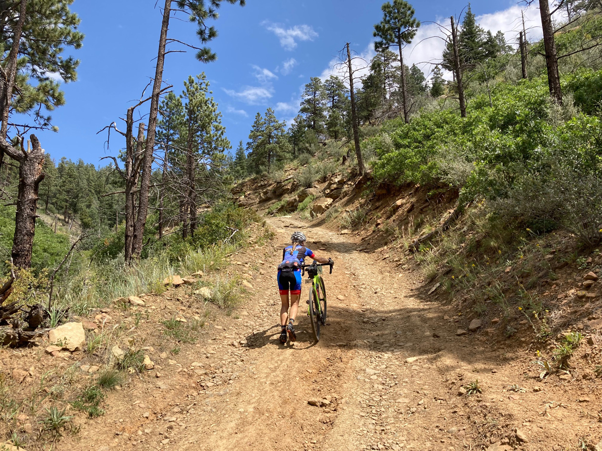
I call this long stretch of the route “Forever Mesa.” It’s beautifully diverse as we wend our way through younger forest, past lush meadows, occasional lakes, and cow ponds, sprawling old burns, and many Scout cabins that serve as base camps for forays into the wilderness. Eventually the primitive 2-track devolves into singletrack and turns into a fun descent through an old burn along an arroyo to Aid Station #3 at Dan Beard Cabins. It’s a strategically placed spot to rest and refuel before The Wall—a quarter-mile hike-a-bike up a 25-30% pitch featuring baby-head size rocks and deep ruts that, as far as I’m aware, no rider has ever been able to ride all the way up. Here I join with Martha, a fit racer from Colorado whom I remember from 2 years ago After doing the Cimarron Challenge for the first time, she told me “Never again!” Yet here she is once more, this time enjoying the ride and laughing when I remind her of what she said way back in 2019. Once we top out on Forever Mesa, she quickly disappears as I pause to take some photos. As the Navajo say, Go in Beauty.
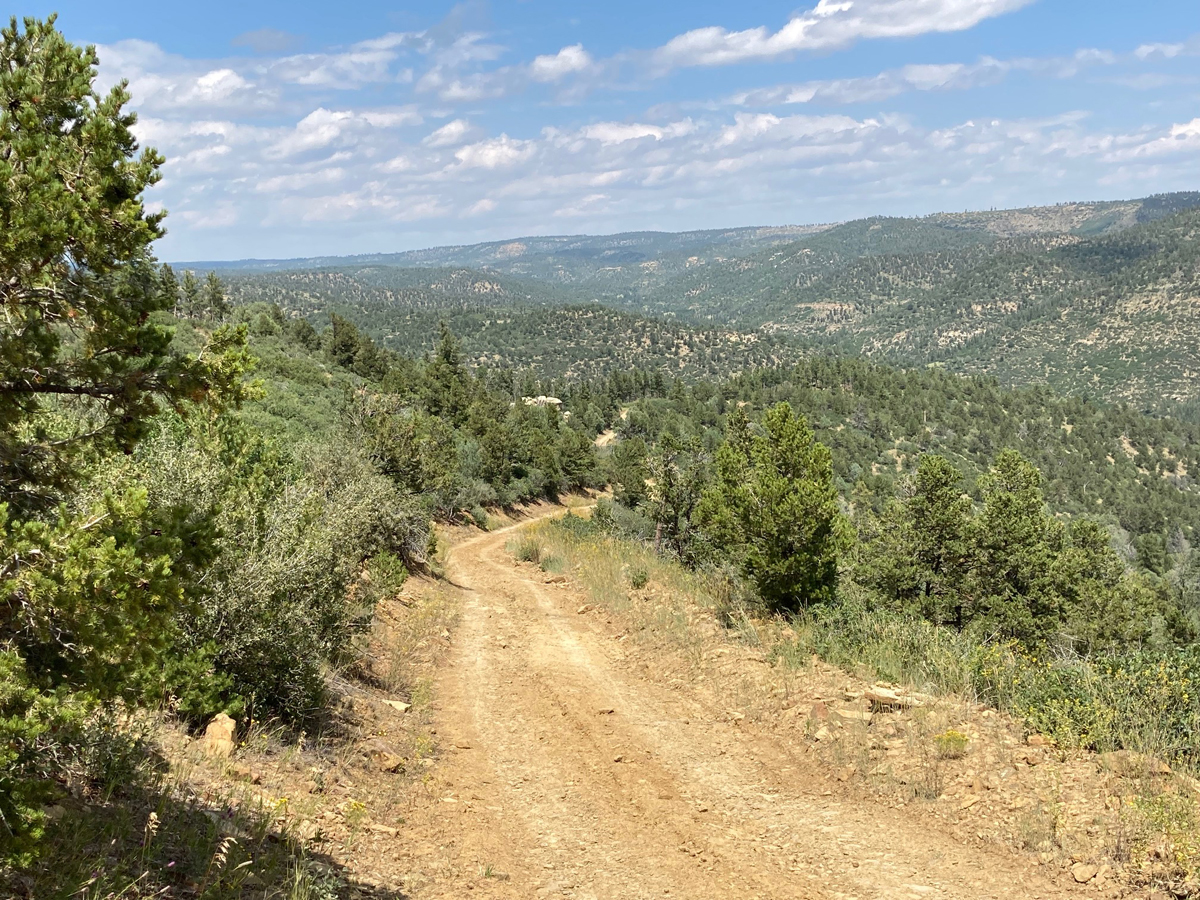
Now comes the most fearsome, and dangerous, stretch of the entire route. The race organizer at the riders’ meeting repeatedly warned cyclists not to bomb down this part of the ride, because of the steep, rocky, rutted sections. And indeed, the monsoon rains have rendered these sections even worse, with deeper ruts exposing more rocks than ever. I gingerly dismount and walk my bike down a few of the worst sections and have a minor slow-speed crash on another section I try to ride. Slowly ever so slowly I descend into Ponil Canyon, with sublime views over countless corrugated canyons and ridges. I breathe a sigh of relief as I bottom out along the creek and end this white-knuckle stretch of the route. I then somehow manage to power my bike through a calf-deep creek crossing, and the cold water soothes my aching feet.
At Aid Station #4 I chat again with the volunteers and refuel for the final 15 miles or so of mostly downhill two-track through Ponil Canyon. Most of the riders have passed through, a few remain behind me, and a few have dropped out— “DNF” in racing parlance. The staffers warn me about 3 more creek crossings, but none as deep as the one just above. “Easy ride from here,” one of them says, but the truth is that it is never easy on the Cimarron Challenge. There are lots more sand traps on this stretch, more rocky stretches, not to mention a brisk headwind as the wind now shifts to the south. But it’s a beautiful descent nonetheless down a fire-scarred canyon with picturesque rimrock walls along a sunflower-lined road (“more sunflowers there than in all of Kansas,” one volunteer from that state tells me). Someday I’ll come back and ride at a more leisurely pace to check out the T-rex track and Anasazi petroglyphs close to the road. Today I am intent on making a respectable time and finishing the race.
After three more creek crossings (two of which I have to walk through), my drivetrain is making horrible noises and I worry about snapping a chain, but somehow it lasts to the finish line. Where the two-track joins with another tributary of Ponil Creek at Six-Mile Gate, the road becomes a county artery, flattens out some, and becomes smoother. I’m still feeling good as I pass the Chase Ranch property (allegedly home to the concept of the Marlboro Man)—I’ve smartly hydrated & eaten well the entire route—and while there is a bucking headwind at least the breeze is cool and refreshing, with temperatures never topping the low 80s.
Then comes the penultimate turn on Highway 64, the last few miles of pavement, then the turn back to the start point at the Brewery. What better place to finish a grueling gravel grinder and celebrate with a cold local brew?
Ever the English professor, I think of Whitman, who wrote:
“I am the man. / I suffered. / I was there.”