“Bosque is Spanish for forest and in the Southwest, the term refers to a riparian forest situated along a river.” — Pattiann Rogers, Home Ground: Language for an American Landscape, ed. Barry Lopez
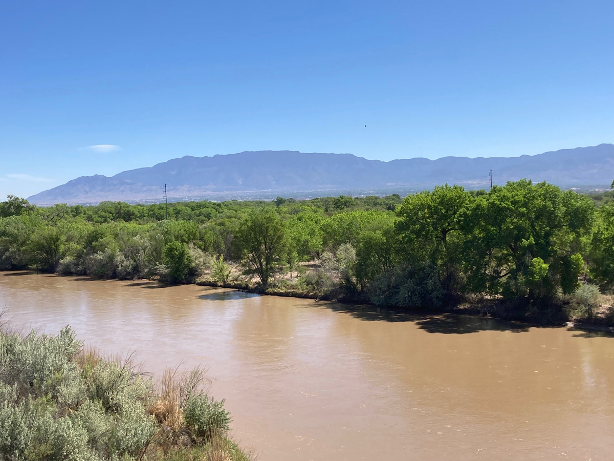
“From the forbidding obscurities of the mountains the Rio Grande emerges again and again into pastoral valleys of bounty and grace. These are narrow, at the most only a few miles wide; and at the least, a bare few hundred yards. In such fertile passages all is green, and the shade of cottonwoods and willows is blue and cool, and there is reward for life in water and field. But always visible on either side are reaches of desert, and beyond stand mountains that limit the river’s world.” — Paul Horgan, Great River: The Rio Grande in North American History
By Don Scheese — When cyclists think of the term “gravel grinding,” what probably comes to mind is an unpaved road or singletrack in some remote national forest or rural landscape. But cities offer opportunities for gravel exploration too. In Albuquerque, a metro area of some one million people, it is possible to find solitude and quiet in the forested oasis of the bosque along the Rio Grande, which divides the city into east and west sectors.
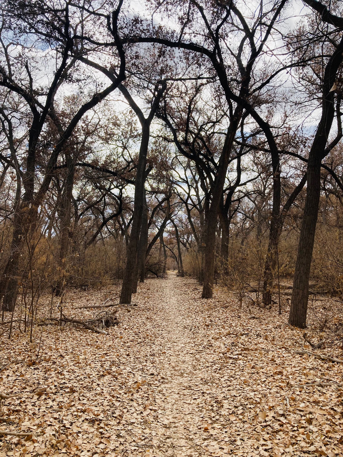
I’m told that this cottonwood forest is the largest of its kind in the world, with trees ranging from saplings to towering gnarly giants well past 100 years old. I bike the bosque in all seasons, at least once a week, and throughout the year the woods takes on different personalities, from jungle-like tangles in the height of summer to open gallery forest come winter.
There is a popular paved trail running north-south for fifteen miles on the east side (free of stop signs as it passes under seven bridges). But less well-known are the gravel and dirt trails closer to, and on both sides of, the river. The trails are twisty and, in a region where Big Climbs are the rule not the exception, mercifully flat. These paths less traveled by offer the unique opportunity, in a bioregion dominated by the brown Chihuahuan desert down low or by dark green coniferous forest at the higher elevations, of cycling for hours through a luminous green shelterbelt of deciduous trees in summer and a kaleidoscope of fall color come autumn. I discovered these trails by accident a few years ago, and they have become my preferred route when I venture to the Big City for a relatively mellow 20–40-mile ride.
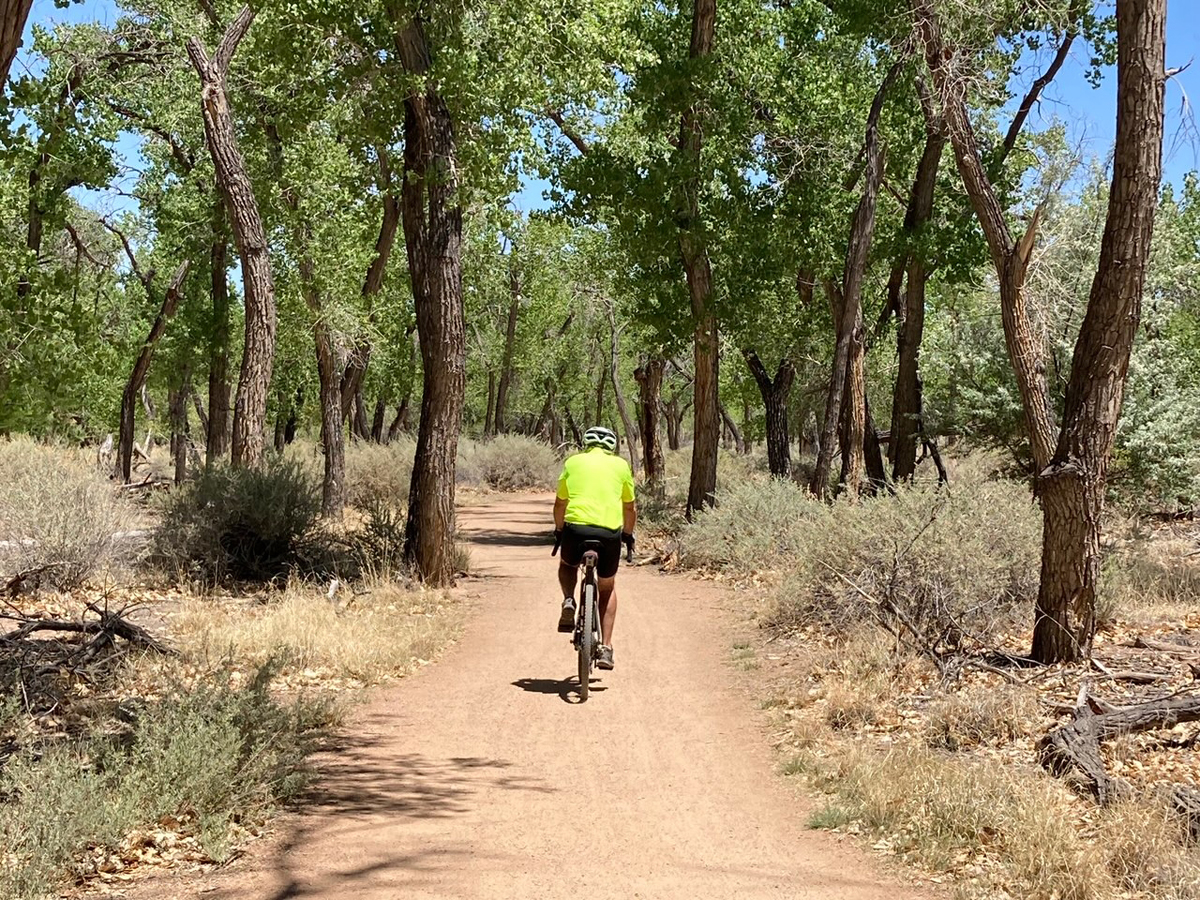
I usually ride the trails on weekdays in the cooler hours of early morning in the summer, and the warmer hours of afternoon in other seasons. Occasionally, I meet a fellow recreationist—walker, runner, equestrian, or fellow cyclist—for the most part, the trails are deliciously free of people, especially on the southern sections on both sides of the Rio. In a maze of trails, I’ve managed to find, by trial and error, the best through routes, avoiding the dead ends and sandy stretches where my machine and I bog down, forcing me to hike-a-bike. Originally carved out and ridden by mountain bikers, these unpaved paths are now frequented by cyclists riding gravel bikes.
I begin the ride at the north end of the bosque path just off Alameda Boulevard, warming up the first mile or so on the paved trail. After passing under Paseo del Norte Boulevard, a busy east-west freeway, I angle off onto dirt fire roads. Here I have a choice: take the singletrack south on the east side of the river all the way to the southernmost bridge at Rio Bravo Boulevard or cross the Rio on the cyclist/pedestrian bridge on Paseo to the west side singletrack trails. Usually I stay to the east, preferring to do a clockwise loop by returning on the west side
Almost immediately, I plunge into a cool green oasis under the towering cottonwoods. But this section, with its understory of tumbleweeds and puncture vine (known locally as goatheads), is notorious for causing flats. One more reason to go tubeless, I think to myself, even though that’s no guarantee of avoiding a softening tire.
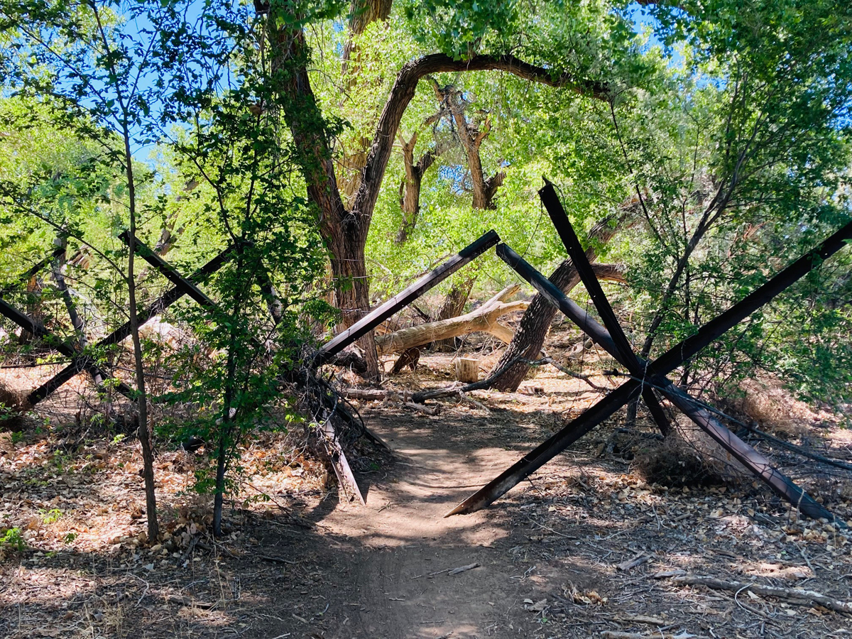
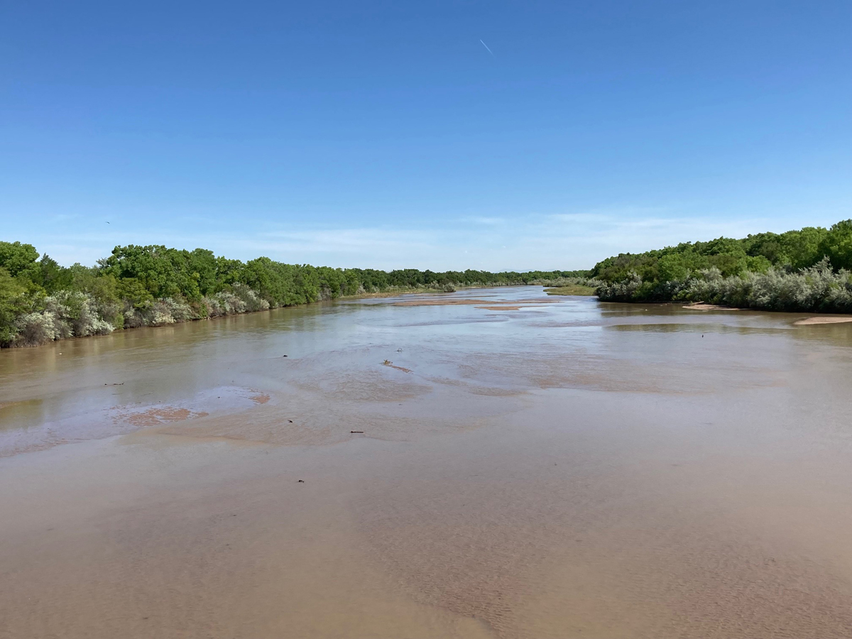
It’s in this section that one encounters strange iron barriers, strung together with thick cable, which are a remnant from the pre-dam era of the Rio Grande. Before a series of dams were built upstream, spring floods were a regular occurrence, and I’ve been told these metal barriers (which look like anti-tank relics from WWII) functioned as debris-gathering devices which then served to hold more soil in place after the floodwaters receded. Nowadays, in the current 20-year Mega-Drought, with diminishing snowpack in the southern San Juan and Sangre de Christo ranges, the river seldom floods anymore.
It’s too nice a day to worry about Climate Change. So, for the next three miles I focus on the winding trail, through metal barriers and clumps of saltbush, before plunging into tamarisk thickets, an invasive species relentlessly trying to take over the bosque. Eventually the singletrack peters out and I have to emerge from the green canopy back onto the paved trail. I proceed for another mile or so until I pass under Montano Boulevard, the next east-west crossing in the city.
Here the off-pavement sector takes on a different character. For the next 6 miles, as it passes through part of Rio Grande Valley State Park, the trail consists of relatively smooth, hard-packed gravel. It’s wider too, and as my speed picks up I sometimes pass by walkers, runners, and fellow cyclists, who often access the trail from Rio Grande Nature Center—a gem of a resource in the heart of the bosque, with interpretive exhibits, friendly staff, and great big glass windows through which one can take in aquatic avian species as well as sunning turtles in the adjacent wetland.
There’s even a mile-long paved section here, called the Aldo Leopold trail, in honor of the patron saint of ecology who once lived in Albuquerque and the greater Southwest. Now come more walkers (often with dogs) and cyclists. Soon though I’m back on the “champagne gravel” (as we gravel grinders like to call such smooth hard-packed surfaces) on another winding section through a particularly fetching part of the bosque. The cottonwoods are of uniform medium age, there’s little understory, and the forest takes on a classic ‘gallery’ look.
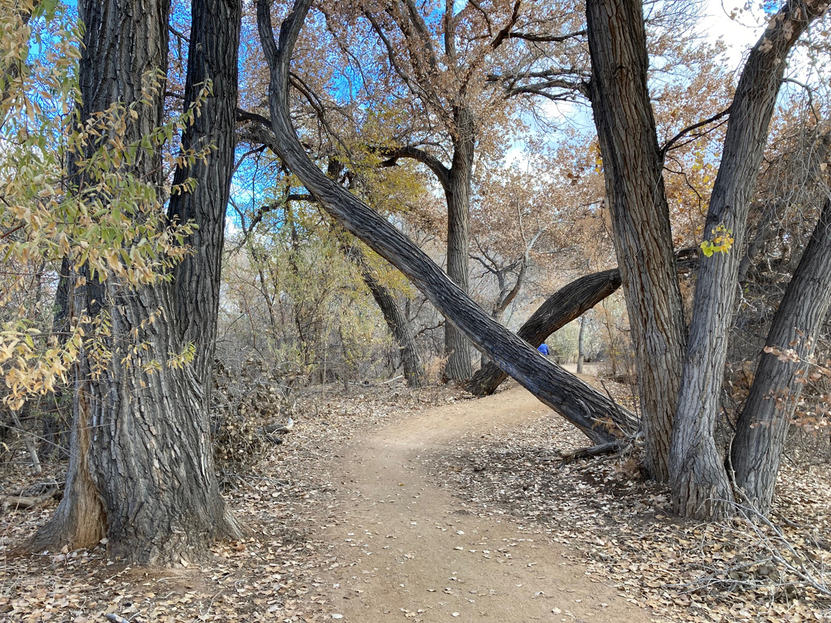
After passing under the next bridge—the humongous span of I-40—I soon thread the needle of what I like to call the “Cross Timbers,” where two massive cottonwoods spaced a short distance apart lean heavily over the trail along some sinuous curves. It’s not a spot where one wants to encounter an oncoming cyclist, but it’s fun to take the corners at high speed while ducking under the tree trunks. Fortunately, I’ve rarely met another rider here. (Alas, the Cross Timbers are no more, as a recent windstorm toppled one of the cottonwoods, and a trail crew bucked up the massive trunk.)
After passing under the next bridge of Central Avenue (which divides the city north-south), the champagne gravel soon ends, replaced by more singletrack where roots of the dominant hardwood trees form the biggest obstacles (There are virtually no rocky sections in the bosque to traverse.) The alternative is to head closer to the river, but deep sandy stretches there prove to be un-negotiable for my 40mm tires. So, I bounce over the roots before soon coming to a wider gravel fire road. More gallery forest ensues, some of it unfortunately singed by recent wildfires started by homeless folk—a year-round danger in ABQ. Just the other day a woman with earlier arrests for pyromania, out on an outstanding warrant, ignited numerous fires again. Fortunately, the flames were quickly extinguished and the perpetrator re-arrested.
Another choice comes: continue straight on a narrowing singletrack, or turn right (west) for a slower, narrower, more challenging route through willow and tamarisk thickets very close to the Rio. I prefer this alternative because it is more solitary and fun to take on. Eventually the two routes merge once again just north of the next bridge, at (appropriately named) Bridge Boulevard.
If I had to identify one section as my favorite, this next one—from Bridge to Rio Bravo—is hands-down the one I most love to ride. Why? Because it’s wilder, more solitary, and offers the best chances of encountering wildlife of various kinds. Plus, it’s smooth singletrack all the way through diverse terrain: from mature cottonwood forest to scrubby brushland to jungle-like tangles of tall trees and low vegetation. The diversity of trees results in a diversity of fall color, from the golden leaves of the tamarisk and mesquite, to deep reds and oranges of vines and maples to, at last, the mellow yellow of the heart-shaped Rio Grande cottonwood leaves.
It’s along this section that I’ve encountered the most wildlife. Porcupines in the trees, coyotes loping through the understory, and come spring and fall thousands of migrating sandhill cranes, ducks, and geese. Oh, how I love to hear the trumpeting calls of cranes and the clangorous honks of geese! That alone makes excursions through the bosque worth the effort.
So thick is the foliage at times that the best birding is by ear. I hear the plaintive drawn-out trill of the spotted towhee, the joyous cackle of robins, the alarm cry of a flicker, the spirited ‘eh eh eh’ of a nuthatch. The sounds of the city seem far away, interrupted only now and then by a passing plane as it descends towards the airport.
Someday I will go on a nocturnal cruise to listen for the hooting of owls.
Before leaving Rio Grande Valley State Park at Rio Bravo Boulevard, I pass by a Descanso—a funeral shrine to a deceased loved one, with white cross and colorful artificial flowers, erected by the family. I do not know the details of the death, but it is a solemn reminder of city troubles and the World at Large.
Crossing Rio Bravo bridge, I pass by another morbid reminder: a ghost bike erected by a local cycling club to mark the spot where a passing motorist struck and killed a cyclist. As if I needed reminding, the traffic on this four-lane highway moves fast and impatiently, and even though I’m riding on a wide shoulder I’m relieved to leave it behind after crossing the Rio.
My route is half-over as I now turn north onto more singletrack on the west side. This part of the route is wilder, more unkempt, as it passes under mature, gnarly cottonwoods and through numerous metal barriers. There are fewer recreationists along this stretch, so the solitude is comforting, and magnificent views of the Sandias to the east emerge through gaps in the forest canopy.
There is a large homeless population in Albuquerque, and some of it spills into the bosque. On this stretch northward to Rio Bravo and Central Avenue I occasionally encounter homeless encampments, and I’ve run into police patrols whose job it is to break up the gatherings. Graffiti is thickly crowded onto the bridge abutments, more reminders that I’m traversing a natural corridor through an urban setting. Though I’ve seen some sketchy characters at times, no one has ever threatened me while riding through the bosque. I do carry pepper spray with me…just in case.
At Central I’m faced with another choice, since to my knowledge there is no direct west-side singletrack that will take me all the way back to and beyond I-40. So, I either have to cross on Central back to the east side and retrace my route or take the bike lane on Atrisco Boulevard which climbs some 300-foot to the I-40 bicycle/pedestrian bridge. I prefer this latter section, for both the climb and the views.
More evidence of homeless encampments at the I-40 bridge—abandoned shopping carts, blankets, trash, and other detritus of the transient and impoverished. “There but for the grace of God go I,” remarked a cycling partner one time as we passed by this scene. Perhaps…I muse over Fate versus Free Will, Choice versus Determinism. As usual, there are no easy answers to this vexing social problem.
Then follows a great descent down the I-40 pedestrian/cyclist bridge, with sublime vistas of the river and mountains. Always I stop at an overlook to take in the views of the ever-changing bosque, the Rio, and the Sandias.
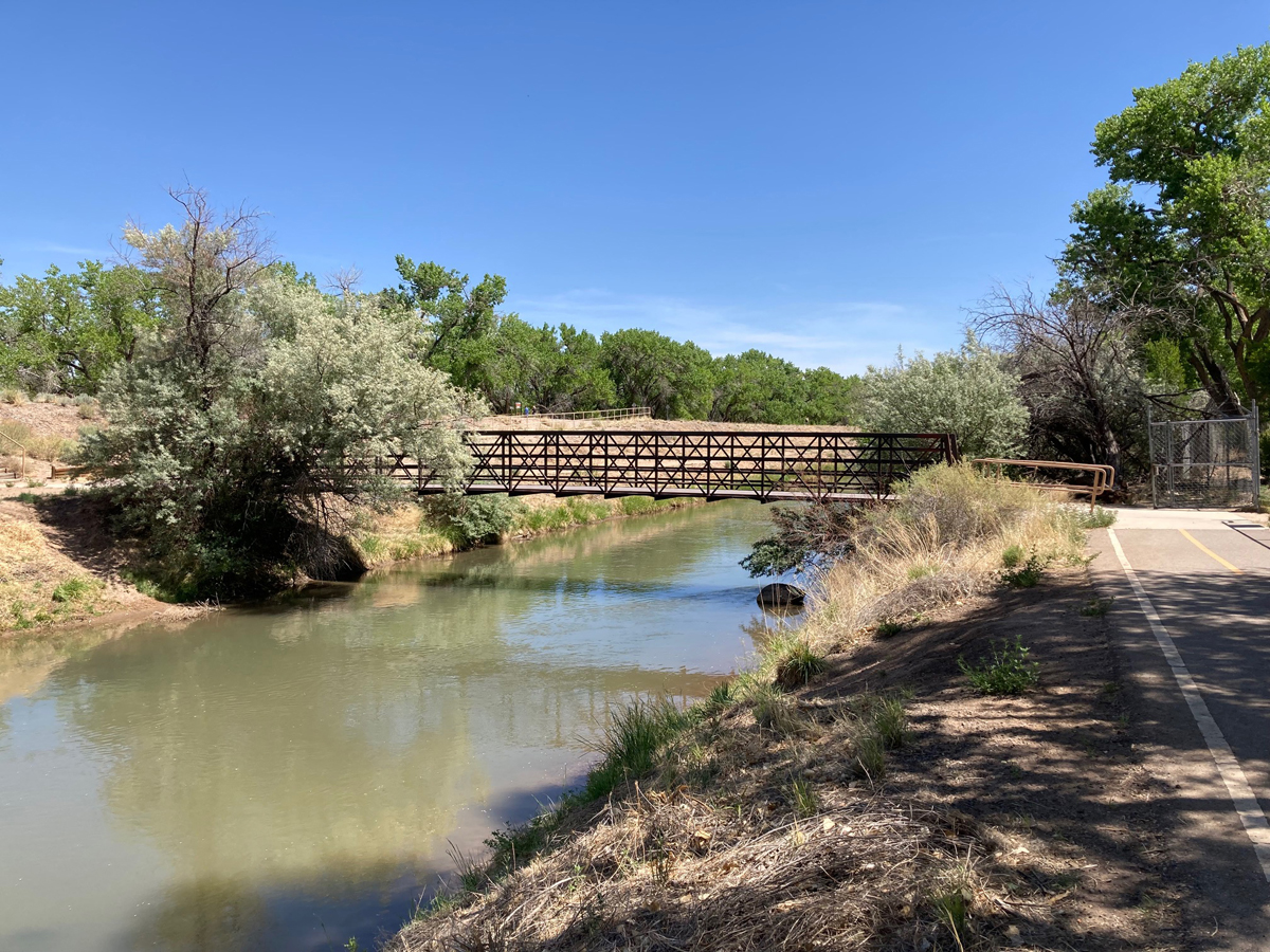
Now I’m retracing my route back on the east side on the champagne gravel again, until I reach Montano, where I regain the paved trail, along a gushing acequia—one of countless irrigation ditches that run from the river to plots of farmland in the heart of Albuquerque. This is part of what gives the city a lovely pastoral quality amidst its brown desert and towering green mountains. The acequia is actually a cultural practice the Spanish adopted from the Moors as early as the 9th century and brought to the Americas in the 1600s. Of course, irrigation was a tradition long practiced by the Puebloans who have lived in the Southwest for thousands of years; the Spanish then went on to refine and institutionalize the tradition. Often times I will see anglers casting their lines in the acequia, and I’m told that the New Mexico Department of Game & Fish occasionally stocks the waterways with trout and other species.
Depending on my mood, I may cross back over on Montano to the west side and ride the singletrack all the way back to Alameda. This section is sandier though and depending on the amount of moisture recently fallen it can be tough to negotiate. This past winter a rare snowfall (rare for the Mega-Drought we’re in) descended on the city, and as a former Minnesotan who used to ride year-round on snowy paths, I couldn’t resist putting on studded tires and layers of clothing to experience snow-cycling in New Mexico. What a treat it was to enjoy a white winter landscape on two wheels, if only for a day or two, in the bosque!
If I do ride this west-side stretch to Alameda, I’m likely to meet with equestrians, as there seems to be more horse-owners in this part of the city. Usually, they are women towering high on gorgeous steeds, and sometimes we stop to chat about the day. I’m always careful not to spook the horse, pulling off the trail well in advance. As the Navajo say, Go in Beauty.
At last, I reach the final bridge, re-crossing the Rio at Alameda. When I return to the car, my Garmin informs me I’ve totaled thirty-four miles of delightful cruising. In ABQ, the only major Southwestern city to have an epic, year-round watercourse running through it, I’m grateful to have experienced this Geography of Solitude and Society in the urban bosque.
Oh, how we Burquenos love this Big Brown God of a River.
Don Scheese is an avid cyclist and retired professor of American Studies who once taught, among other things, courses on Lance Armstrong and Sport in American Culture.