By John Higgins — Bikepacking websites and blogs are full of trip ideas and reports, but it’s always satisfying to scheme one up from scratch and have it roll out as planned, with all expectations met. Such was the case in late Fall when I declared a mental health break from the pandemic, work, and house moving to circumnavigate Bryce National Park over several days of leisurely bike packing / bike touring / gravel grinding. Call it what you like but it was delightful.
The route concept arose several years ago during an abandoned trip in Grand Staircase-Escalante National Monument due to uncommonly wet weather and tire mugging bentonite clay. Whilst implementing Plan B of hiking instead of biking, I started pouring over maps to scheme up a future tour. This led to periodic peering at paper maps and Google Earth, and internet trawling for trip reports and trail gossip. The idea was to circumnavigate around Bryce Canyon National Park, taking in the East Fork of the Sevier River and the Paunsaugunt Plateau, and to keep to gravel roads as much as possible. In theory and on paper there was a route, but it more than likely included substantial hike-a-bike sections on the Grandview Trail. I’m no stranger to self-inflicted suffering but on this tour, I wanted my bike to carry me, instead of the other way around. Once I relaxed my criteria to include pavement an 80-mile circular route fell into place quickly, plotted out on ridewithgps.com.
The next step was to determine feasible water resupply points, camping options, and direction of travel. I elected to travel counterclockwise starting and finishing in the hamlet of Cannonville, and knocking out a substantial elevation gain on paved highway 12. This added driving time from Salt Lake City, but worked better for my route itinerary. I choose to split the route up into 3 half day chunks of riding, with two nights camping out. With vehicle commuting time it was a full 3-day outing. A devoted gravel racer could blast through this route in a day. A committed bike packer travelling light could easily do it over two full days. I wanted time to relax, lounge at campsites, and enjoy the scenery.
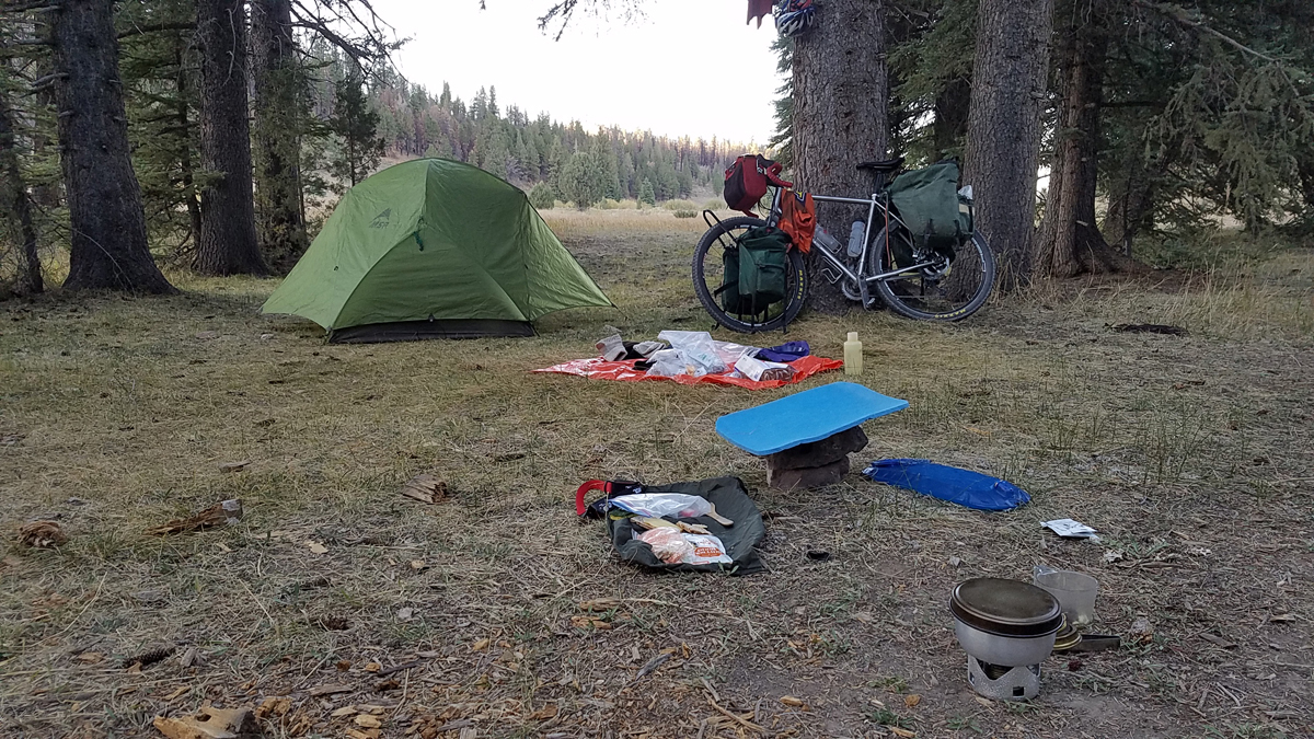
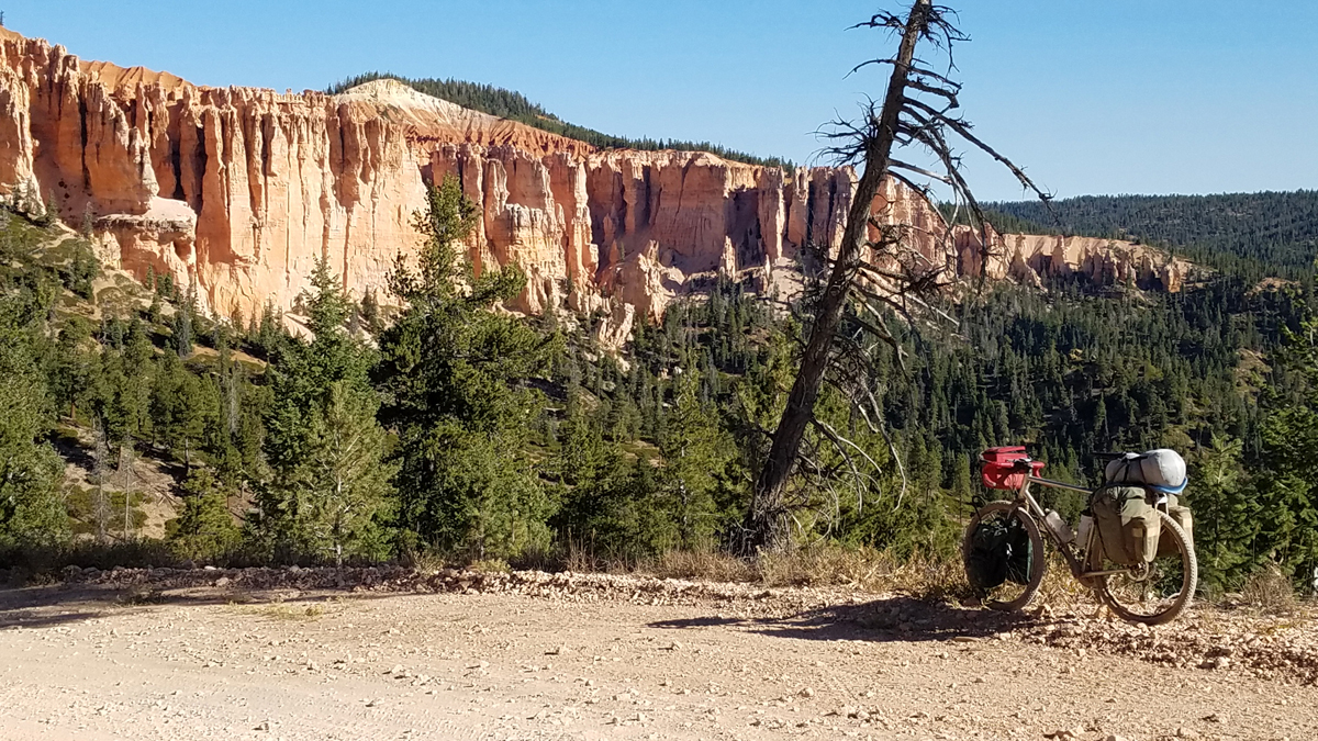
After travelling from Salt Lake City one morning at the end of September, I wheeled out of Cannonville in the early afternoon and up Hwy 12 towards Bryce. Due to road works and lane closures I had long stretches of car-free bliss, and then a concentrated burst of traffic blowing by me. It actually made this stretch of somewhat sketchy road riding far more palatable than it might have been. Once I reached the turnoff to Bryce Canyon National Park, I scooted onto the bike path that parallels the road towards Red Canyon. This kept me going for a few miles until the turnoff to Tropic Reservoir. A wide smooth-ish gravel road (FR#087) beckoned, and the gravel riding began. From online research I knew there was a water resupply point in the form of a spring somewhere near the head of the reservoir. This proved to be well signed and right next to the road, diminishing the challenge of finding it. Camping is restricted to designated sites along the East Fork of the Sevier River, and I got lucky finding the first site vacant. Forsaking the dustbowl parking lot for a grassy swale near the burbling stream made for a pleasant evening with warmer than expected temperatures, and a well-earned meal after 4 hours of turning the cranks. Day 1 and 28 miles down.
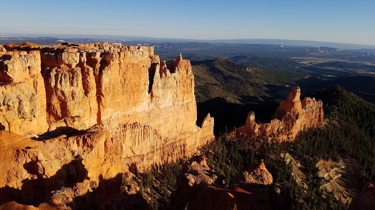
The destination for the end of Day 2 was the Pink Cliffs Viewpoint, which came highly recommended from those who have travelled before me. The main road along the river would convey a rider there swiftly, but I took the scenic side route in the form of the Great Western Trail / Paunsaugunt ATV trail to Crawford Pass. No ATVs were sighted, and the doubletrack was in great condition and made for perfect riding, as well as offering up picturesque valley views. Along the way I passed another piped spring which a smarter person would have used to tank up for a dry campsite, but I thought I’d find more water further on. The maze of roads and trails converging on Crawford Pass made for a navigation stop. I made a choice and exited the pass on a relentlessly steep grade (the main ATV route), which gave me plenty of grunting time to contemplate the wisdom of my decision. There are a couple of gentler but longer alternatives, either of which would have been more sensible, but I persevered and reached the top of the plateau, where increasingly impressive views gradually unfolded. The Pink Cliffs did not disappoint, and having arrived in the early afternoon I had plenty of time to wander around and soak in the expansive views.
There was however the small matter of having only a couple of bottles of water left. Pouring over my map collection, one indicated a spring about 4 miles away. The 4 miles downhill to get to it was of no concern, but what was of concern was if I could not find it, or it was dry, and then I had 4 uphill, water consuming miles to ride back to camp which would make for a parched evening. Having assessed the risk/reward outcomes of the situation I set forth with an unloaded bike, empty Camelbaks and bottles, filter and map. The descent was fast and fun, but I got to a point beyond where the spring would have been without success. Dejectedly retracing my pedal strokes, I caught the gleam of water off to the side of the road, masked by floating aspen leaves. Going past the first time, the leaf covering and angle of light made it difficult to see the trickle that was routed under the road by a small culvert. While collecting water from the source of the spring a hundred yards off the road, I discovered I was being filmed by candid wildlife cam. Fortunately the water supply was too tiny to have warranted a stripped-off dip, or the Utah DWR officers reviewing the camera might have gotten more of an eyeful than they expected.
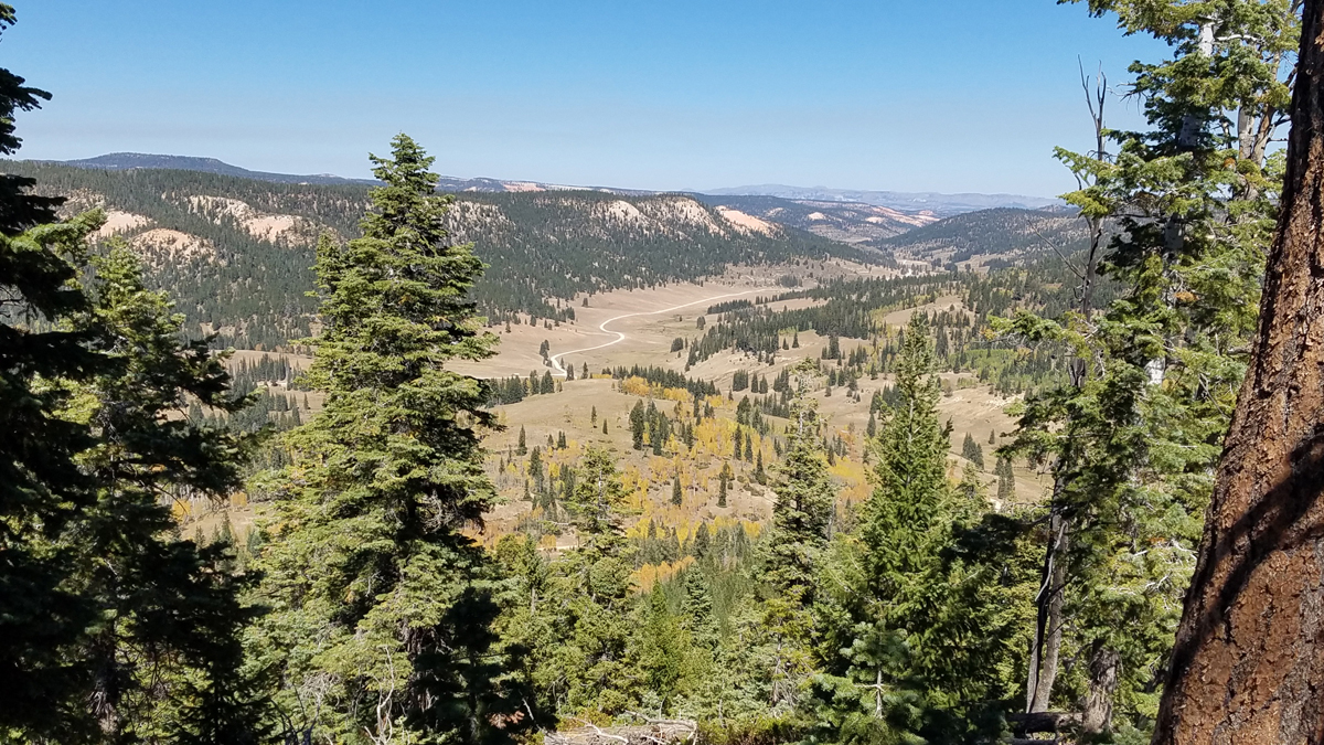
Day 3 dawned as another perfect day in paradise. Having packed up my stealth camp, the way forward was enjoyably downhill on FR203, the surface of which varied from smooth and firm to loose, rocky and very dusty. The reward was more spectacular views of the cliffs around the plateau, before speeding out the private road/public access route between Dixie National Forest and the Skutumpah Road. There ensured a very different scenery of low elevation desert riding complete with sand traps. Passing the hiking temptations of the Bull Valley Gorge and Willis Creek trailheads and slot canyons, I encountered a jackknifed horse trailer blocking the road to motorists in both directions. This proved of little obstacle to a bike tourer, and I arrived back into Cannonville on schedule, washed off the dust at a spigot in the local park and motored back to the metropolis, revived and refreshed by a few days in the woods.
Route Notes
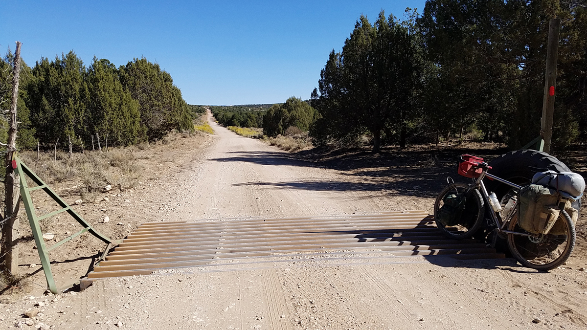
The entire route was on vehicular roads and trails, ranging from paved highway to good quality ATV trails, and most of it was within Dixie National Forest. Being a circular point to point route, it is possible to pick a start / end point and direction of travel to suit your intentions. The route I did, and the time taken / mileage per day would be an excellent outing for beginner bike packers who are confident cyclists. The East Fork of the Sevier River Valley is promoted as an ATV playground, and there are many roads and trails in this area which could be added into the mix by way of side trips or clover leaf add-on loops. There is more bike exploring to be had there. I choose to go mid-week to minimize interactions with other recreational users, and enjoyed a largely vehicle-free outing.
You can find my route here: https://ridewithgps.com/routes/34150841
Gear
My gravel touring bike is an Otso Warakin with a Rodeo Labs Spork 3.0 front fork. I prefer front and rear racks and panniers over soft strap-on bags for nontechnical gravel touring. I ran a mountain bike wheelset (27.5 x 2.1) but the route would be suitable for 700 x 40 tires or similar. I like the extra traction and comfort of the mountain bike tires for being as loaded as I was. I’m more interested in travelling with camp comforts and emergency gear than going as light as possible, so had a tent, sleeping bag, camp stove, water filter, emergency equipment (GPS, location transmitter) and a selection of spares and tools.
Although I had the route loaded into my Garmin, it is advisable to carry “real maps” to show not only the big picture, but alternative routes and resources should the need arise. Maps used: National Geographic #714: Grand Staircase Paunsaugunt Plateau; Adventure Maps: Bryce Canyon and Brian Head.
John is my Son, and I’m very proud of his adventurous spirit; his self discipline and his writing skills. Love Mum