By John Roberson with help from Roz — My sweetheart and I recently spent 10 days in October touring by bicycle in Eastern Kansas. We rode on repurposed railway grades, dusty back roads and the paved streets of small towns and cities. We encountered interesting people and other animals along the way. We set up cozy camps in pretty places and stayed in cushy hotels, and we ate very, very well. The following is a brief description of that wonderful trip.
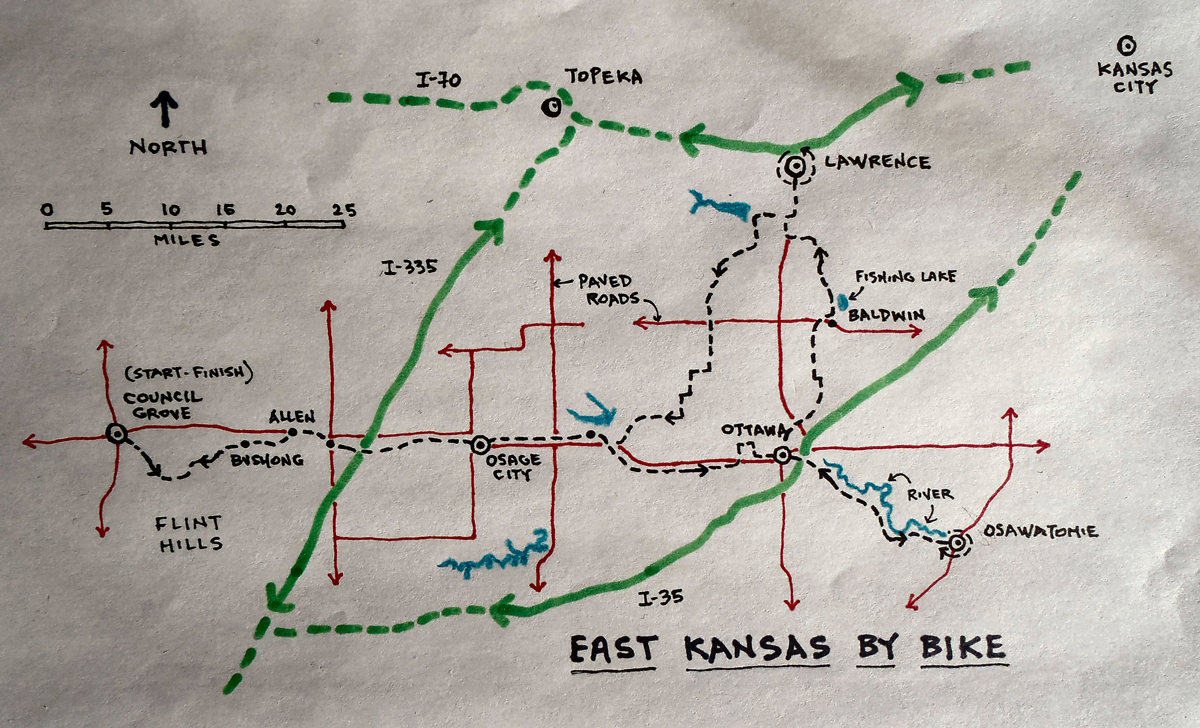
Roz is a Kansas girl, born and raised, and for years we have made trips back to her hometown of Lawrence in order to visit with her mother and to connect with old friends. Kansas is a lovely place. It’s always been good to return, and this would be our first trip back since her mother’s passing a few years ago. We planned to park the truck in some convenient spot, wander around by bike for ten days or so, then return to the truck for the ride back home. Along the way we’d ride a few established Kansas rail-trails and spend a few days exploring Lawrence and its surrounding countryside.
It’s normally a two-day drive for us, from our home in Salt Lake to Lawrence, but our destination this trip was the small city of Council Grove, about sixty miles southwest of Lawrence. Once a major stop for travelers on the historic Santa Fe Trail, Council Grove is also the current western terminus of the Flint Hills Nature Trail, which was our first objective.
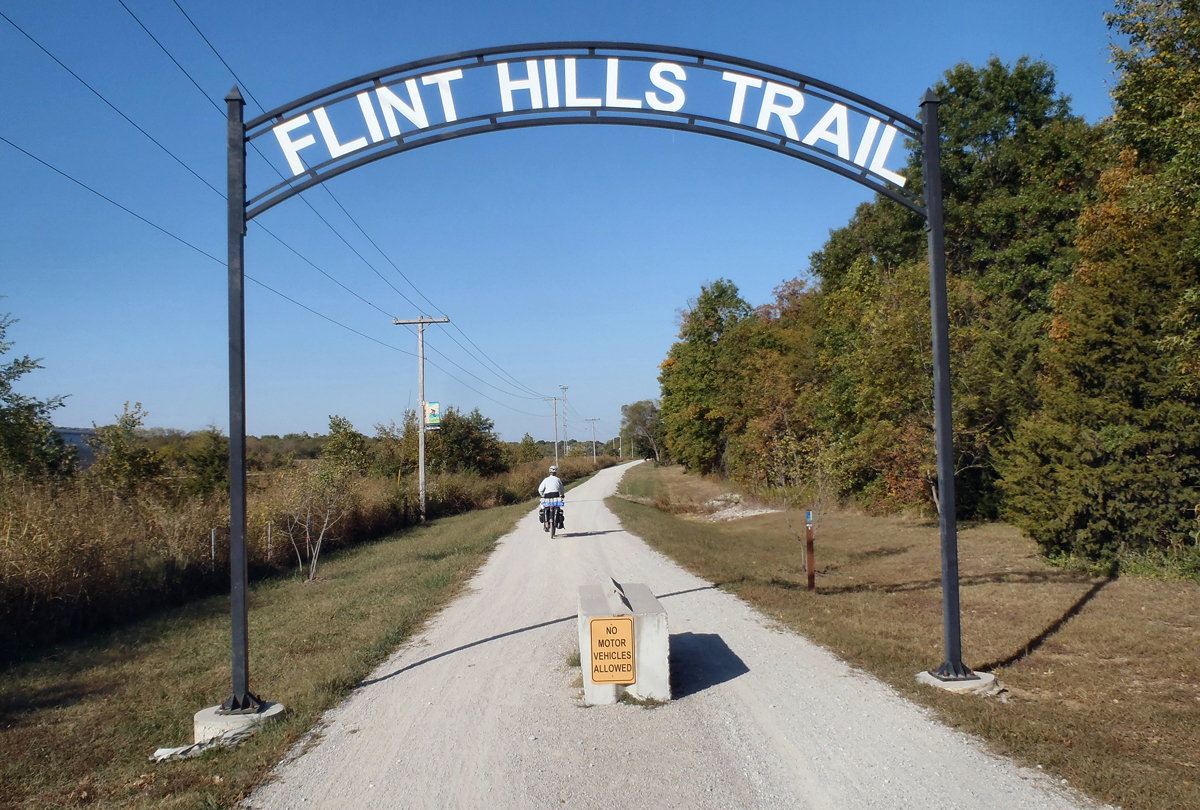
The Flint Hills Nature Trail started out in 1880 as the Council Grove, Osage City and Ottawa railroad. It later became the Missouri Pacific (MoPac) and continued to service the communities along its route until its abandonment in the 1980s. The Rails to Trails Conservancy (a national non-profit dedicated to transforming abandoned rail corridors into non-motorized trails) acquired the rights of way to the rail corridor, then passed those rights onto the local Kanza Rail Trails Conservancy, which over the years has developed more than 60 miles of the route, mostly through volunteer efforts. The route is now a state park maintained by the Kansas Department of Wildlife and Parks.
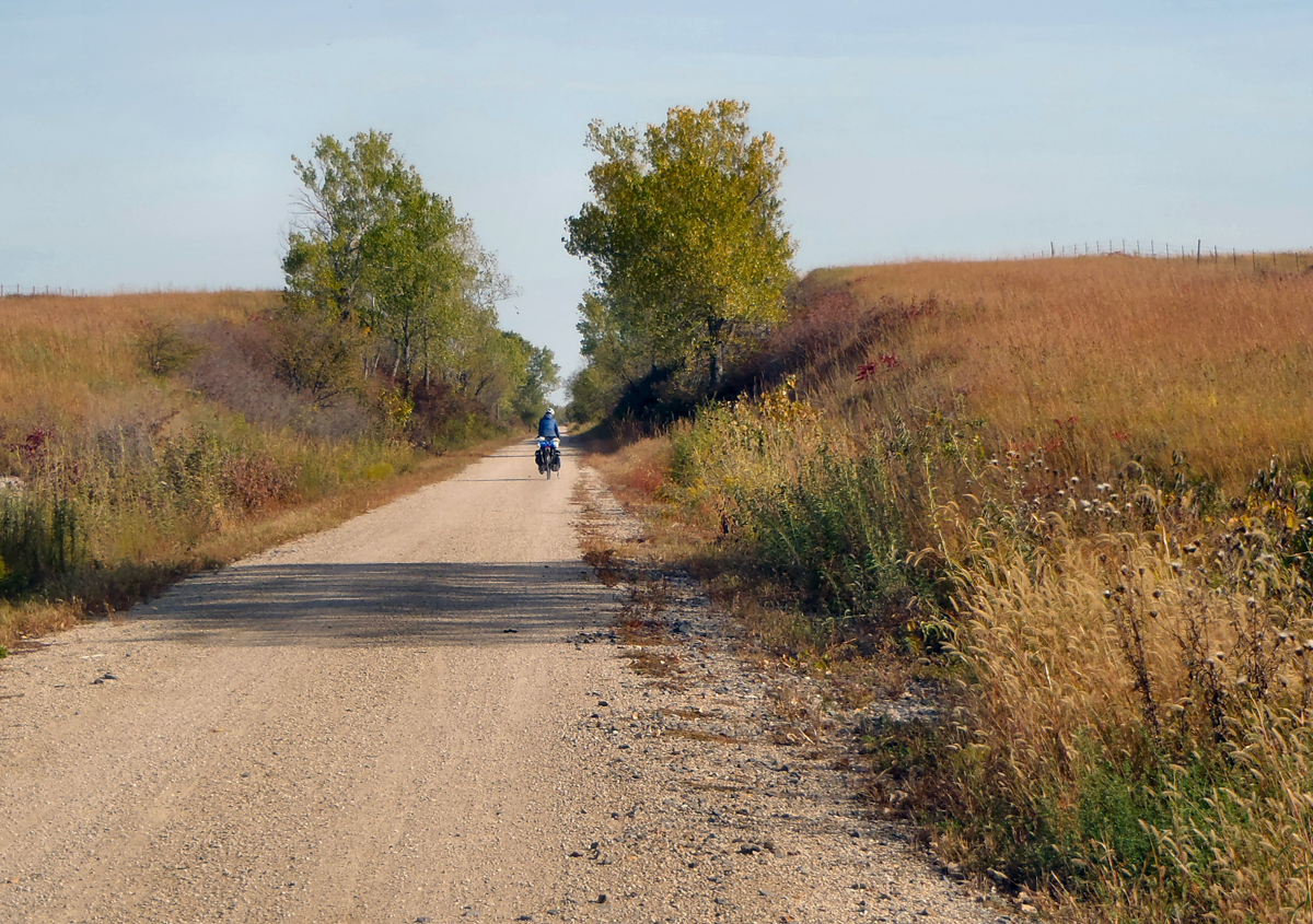
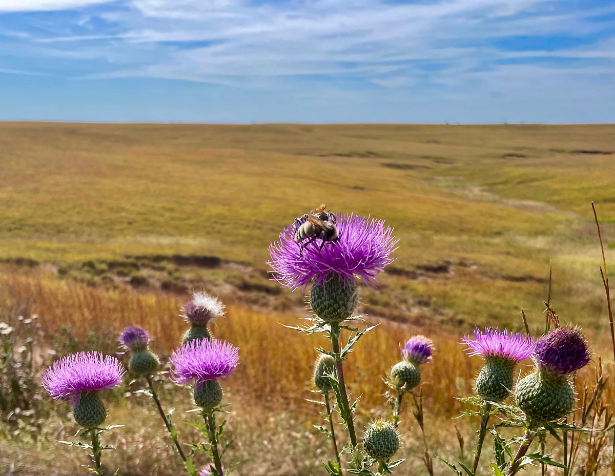
We pulled into Council Grove at the end of the day and set up our camp at the trailhead east of town. On the following morning, which dawned clear, cool, and calm, we loaded up the bikes and began our journey east along the trail. We rolled through shady “tunnels” of green, where trees arched over the trail from either side, past open fields and rolling hills covered by some of the last expanses of the Tallgrass Prairie ecosystem that once covered the whole of the American heartland.
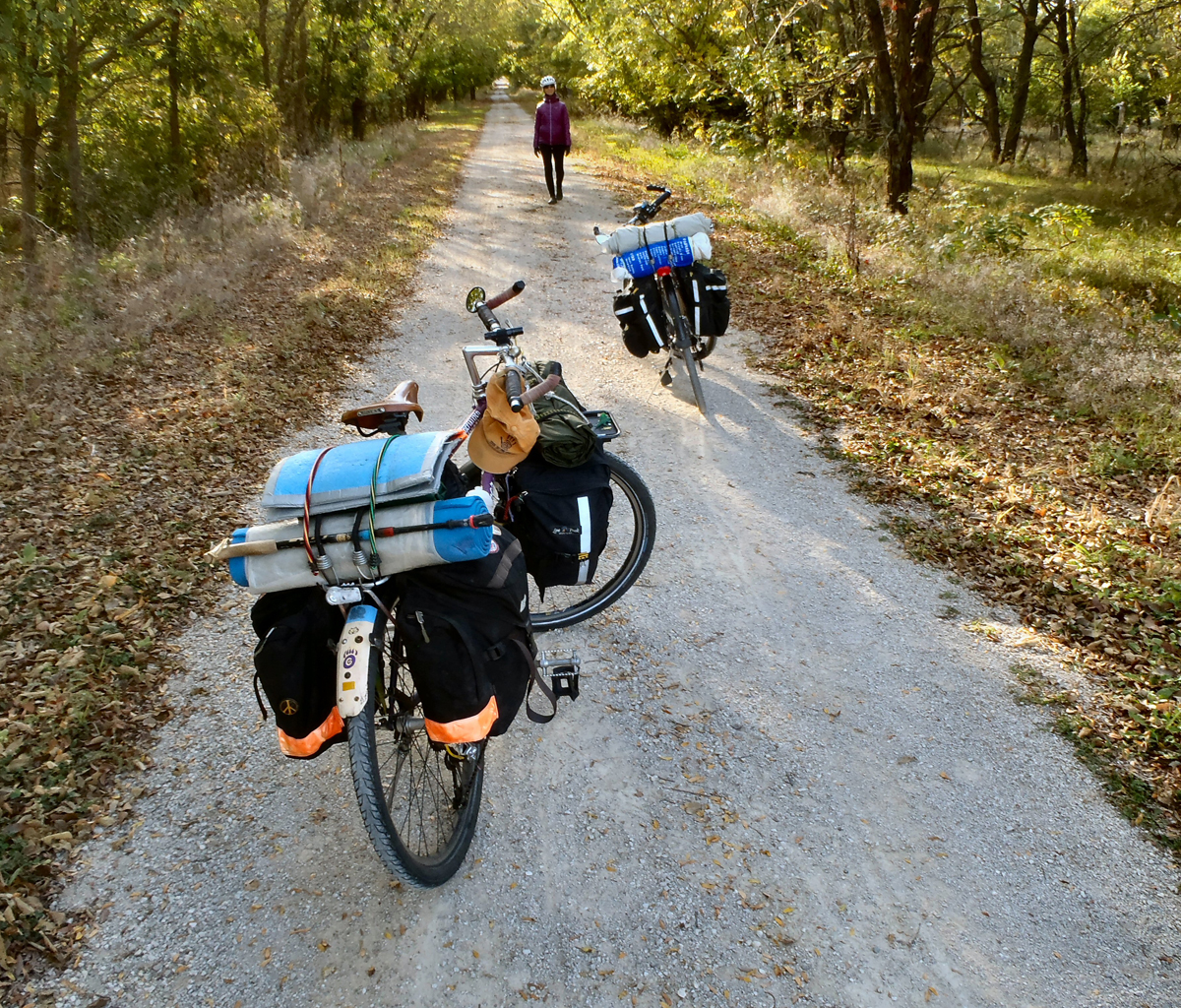
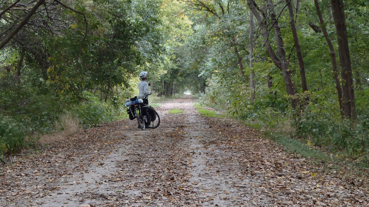
The trail itself was a pleasure to ride. The crushed stone surface was smooth and manageable (despite sometimes having to dodge walnuts, hedge apples and the occasional snake or turtle!) and the old rail grade’s cut-and-fill structure really smoothed out the ups and downs of the rolling hills. It was clear from the start that considerable effort went into the original trail work. Access to the trail was well-controlled with barriers and regular signage, and we passed a couple of semi-developed, public resting spots along the way, each consisting of a pit toilet and a small, covered picnic pavilion (but no tables and no water). We often had the feeling that we were riding in the “off” season. The pit toilets were all locked up and we saw surprisingly few people during the four days we spent on the trail.
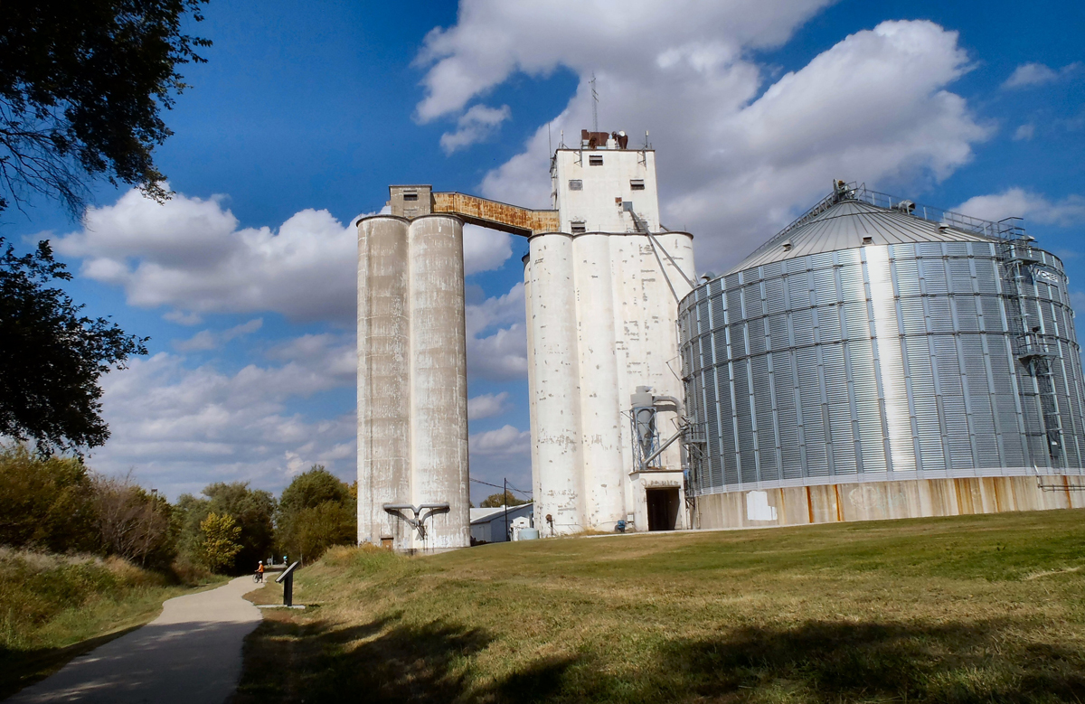
During that first day of riding, we passed through the very small towns of Bushong, Allen, Admire and Miller. Though we found no commercial services in any of the towns, each was lovely in its own way, well-kept, quiet, and marked with a Great Plains staple: a community water tank towering over it all.
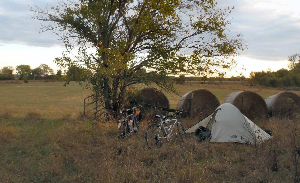
By late afternoon we had covered 40 miles or so and were starting to think about a camp for the night. We stopped for cold drinks and snacks in Osage City, a fair-sized town just off the trail, after a short, undeveloped section forced us to leave the trail. We passed through town, joined the trail again less than a mile from where we’d left it, then rode on for a few more trail miles before setting up camp on the edge of a fallow field. We fixed our evening meal, shared thoughts and impressions, then settled in for a well-earned night’s sleep, comforted by the familiar sounds of hooting owls, yipping coyotes, and tiny critters moving around in the underbrush.
Our second day of riding took us through the towns of Vassar and Miller (again, no apparent services), onto a short, well-marked, off-trail detour through the countryside to the north, then on to the college town of Ottawa, the largest community on the trail. We replenished our supplies and had a delicious sit-down meal at a local cafe across from the county courthouse. We were back on the trail by mid-afternoon heading south and east towards the town of Osawatomie and the eastern end of the Flint Hills Nature Trail. This 20-mile stretch of the trail was especially nice. Its shady “tunnels” of green kept us cool as it ran adjacent to the mellow Marais des Cygnes River.
We approached the town of Osawatomie as the day was winding down. We asked a couple of cyclists we met where we might camp for the night and, as they gave us their ideas, we were joined by an enthusiastic crowd of cyclists out for their weekly evening cruise. They were all eager to share their enthusiasm for the trail and suggested we head for John Brown Park, a mile or so from the end of the trail. What a great group they were!
The town of Osawatomie (from the tribal names Osage and Potawatomie) was founded in the early 1850s by abolitionists from the east. Like their fellow “free staters” from Lawrence, the citizens of Osawatomie were fervently anti-slavery. And like the citizens of Lawrence, they were persecuted for their views by the pro-slavery “border ruffians” from nearby Missouri and suffered from violent attacks. John Brown Park memorializes a battle the took place in 1856 during which a small group of abolitionists, led by the infamous John Brown, were defeated in a battle that cost many local lives and resulted in the destruction of the town. We camped in the park that night and, despite the grim historical circumstances, slept quite well.
We were up early the next morning and back on the road on what looked to be another beautiful Kansas morning. Having completed our first objective by riding the length of the Flint Hills Nature Trail we were now thinking of Lawrence, about 40 winding miles from Osawatomie and the scene of the second phase of our adventure, we decided to avoid the more direct highways to Lawrence and instead backtrack along the trail to Ottawa. We would return to Ottawa by the same trail, but at a different time of day and from a different perspective. On the way out of town we ran into another set of local trail-riders, Jeff and Sarah, who were out for a morning ride. Sarah explained to us why she had a garden rake attached to her handlebars (to brush away spider webs), and Jeff spoke of his on-going efforts to refurbish and donate dozens of old bikes to his community. Nice folks!
The leisurely ride back up river to Ottawa made for a very nice morning and, after another delicious meal in town, we swapped the peaceful, cushy comforts of the trail for the potential hazards of Kansas public roads.
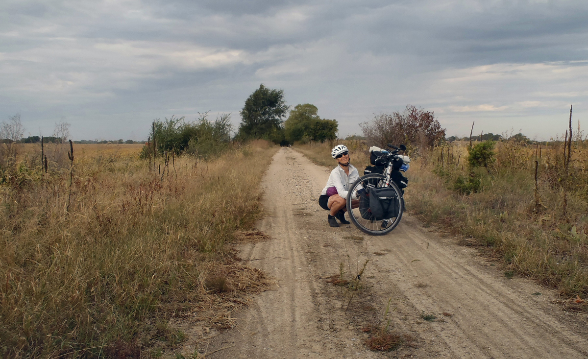
There are roads everywhere in the eastern part of Kansas, and most are either straight runs laid out in a north-south, east-west grid or winding, modern versions of historic ridge-top or river trails. The paved roads are smooth and well-maintained but often lack meaningful shoulders. The many dirt roads, while inherently slower and often dusty and hillier than the paved roads, were much quieter and so allowed us to appreciate our surroundings and ride at a much less stressful pace.
After winding through the neighborhoods north of Ottawa we found ourselves on dirt roads out in the open countryside. The roads were quiet, and we had grand views all around, but we were into hilly terrain and now had a persistent north wind to deal with. And to add the mix, I had to backtrack a couple of miles to retrieve a forgotten map packet. Nevertheless, we thought it was a pretty nice afternoon to be riding.
Our objective for the night was a Kansas state fishing lake north of the small city of Baldwin. We arrived around sunset, found a lovely site near the lake and set up our camp as the light faded from the day. We stretched our weary bones, had our evening meal, and talked about all the ways we might spend our upcoming time in Lawrence.
We spent the next morning winding our way north on backroads towards Lawrence. Although Roz knew the area well, and together we had explored much of the countryside around the city during previous visits, we were struck by how much things had changed in recent years. Old two-lane bypass roads were now four-lane highways and the ever-expanding suburbs seemed ready to fill every available field and meadow. It was all a bit disorienting. At one point, as we stopped to check our maps, a passing highway patrol officer asked if we needed help! After a very pleasant exchange of ideas, we persevered and soon found ourselves on the familiar South Lawrence Trafficway, a hard-surfaced bike path that runs more than eleven miles along the south and west edges of town.
We had the first of many sit-down meals in Lawrence at a Japanese restaurant on the south edge of town, then carried on into the city’s central business district. We checked into the historic Eldridge Hotel in downtown Lawrence for the first of five nights of relative luxury, then set about rediscovering the town we both (Roz especially!) liked and knew well.
Lawrence is a college town of about 100,000 people, home to the University of Kansas and Haskell Indian Nations University, as well as all the cool amenities associated with a socially progressive, college town. It was founded in the 1850s by determined anti-slavery immigrants from Massachusetts and was the scene of many violent confrontations between pro- and anti-slavery factions before and during the Civil War. In 1863, many men and boys were killed and Lawrence itself nearly destroyed during a raid by Quantrill and his Confederate raiders.
We spent the next five days riding (and walking) all around town, exploring familiar museums and attractions and eating in lots of different restaurants. Roz visited with old friends, and I found cozy spots to while away the sunny afternoons. We sampled the excellent beer from the Free State Brewery, enjoyed a delightful vegetable korma at the India Palace, and took in the dusty dioramas at the KU field museum on campus. We traveled nearly everywhere by bike, taking advantage of both designated bike paths and peaceful, brick-surfaced neighborhood lanes. One day we rode out on the levees that keep the Kansas River floodwaters from inundating the town during flood times, and on another day discovered the short, but sweet, Burroughs Creek Trail east of town.
Throughout the trip, so far, the weather had been good. The temperatures were a little on the warm side, considering the time of year, but the skies had been blue and the beastly Midwestern winds that had bedeviled us during past tours were kinder to us this time around. We faced no wet weather while riding, but we were treated to an awe-inspiring thunderstorm on the night before we planned to head out of town. The wind howled, torrents of rain fell, and the thunder and lightning put on a steady show for over an hour while we hunkered down in our cozy room at the Eldridge.
We checked out the following morning, said goodbye to Lawrence, and began our trip back to Council Grove. The storm had cleared the air, dampened the earth, brightened everyone’s spirits, and made for perfect riding conditions as we headed south, out of town. We spent the day riding quiet, paved, and graded country roads, passing Lone Star and Pomona reservoirs along the way. Late in the day we were forced onto a stretch of busy highway south of Pomona Reservoir but were back on the Flint Hills Trail again an hour or so before sunset. It was a relief to be back on the trail where the only sounds were the crunch of tires on the crushed limestone trail base and the calls of birds in the brush and woods beside the trail. We made our camp east of Osage City and enjoyed another restful night’s sleep.
The following morning found us well-rested but facing what would turn out to be a somewhat trying day. Despite the quiet comforts of a familiar trail and the certainty of another beautiful October day, we faced a stiff headwind all day long. It was easier for us to manage when riding through the “tunnels” of green where the foliage lessened the force of the wind, but when we rose up into the open Flint Hills to the west we had no choice but to gear down and plow through. Of course, every bicycle tourist has to face windy conditions now and again, and we took comfort in realizing that, in terms of Kansas breezes, it had been a piece of cake for us thus far. As experienced tourists we knew that whether facing ups and downs, headwinds or tailwinds, rough roads or smooth, it all balanced out in the end.
The winds eventually mellowed, and the late afternoon sun was settling into the west as we arrived back at our starting point in Council Grove, a bit surprised that we had made such steady progress. We had anticipated spending another night on the trail, but instead found ourselves loaded up and ready to head home around sunset. We had a meal at Hays House in Council Grove (reported to be the oldest, continuously-operated restaurant west of the Mississippi) then started out of town.
On the way out of Council Grove, the flashing red and blue lights of a city police cruiser caused us to stop. Not knowing what to expect we were greeted by a friendly officer who assured us that we weren’t in trouble and that he only wanted to ask us about our trip! We had left a note on our vehicle’s dashboard describing our general itinerary, which the officer had seen. It turned out that he was a newcomer to the area and curious about the trail and its possibilities, which we were happy to describe. It was a nice encounter, and it seemed fitting somehow, given all we had experienced, that there we were, a couple of out-of-towners just off the trail and already extolling the virtues of a local resource that we had come to feel we could call our own.
Interesting travelog. It is no longer the Flint Hills Nature Trail but the Flint Hills Trail. Looks like they wild-camped along the trail east of Osage City. The state park rules don’t allow that.
Nice write up. I wondered about the trail after riding a small portion of it one year at Unbound gravel. Sounds like it could make a nice post-Unbound bikepacking trip if I had the energy. Thanks for sharing. Great trip!