By Lou Melini — Parks, Peaks and Prairies is a new route mapped by the bicycle travel organization, Adventure Cycling Association. The full route runs from West Yellowstone to Minneapolis and is covered on 3 maps. My wife Julie and I used Map 1 for the West Yellowstone to Greybull, Wyoming part of our tour starting on Labor Day in September of 2021. Our intended route would take us through the prairies east and south of Cody, Wyoming, through Yellowstone National Park and across the peaks of Chief Joseph Scenic Highway and the Beartooth Highway between Cody and Cooke City, Montana.
This tour was the first tour Julie and I have done since our ride across the U.S. in 2018. I was anxious to not only get out on a bike tour with Julie, but on how to plan the logistics to satisfy our current interests and expectations.
I spent weeks planning and revising the intended route, changing it six times, the last being on day 2 of our trip when I shortened our ride by one day. I lost sleep, once poring over a map at 2 AM. I consulted with two WarmShowers.org hosts that lived along the route and one district ranger for advice on my intended route.
Weather, wind, elevation changes and forest service (FS) campground availability were significant considerations for a September tour in the high country of Wyoming. In addition, I wanted to include the “tourist” attractions; the Buffalo Bill Center of the West in Cody, a world-class museum, and the Hot Springs State Park in Thermopolis. The scenic highways, Chief Joseph and Beartooth have long been on my bucket list. Yellowstone National Park is always an attraction. Julie’s physical conditioning and my anxiety pushed me to plan shorter days than our earlier tours, so the final route we took was a “figure 8” with Cody in the middle
The Basics:
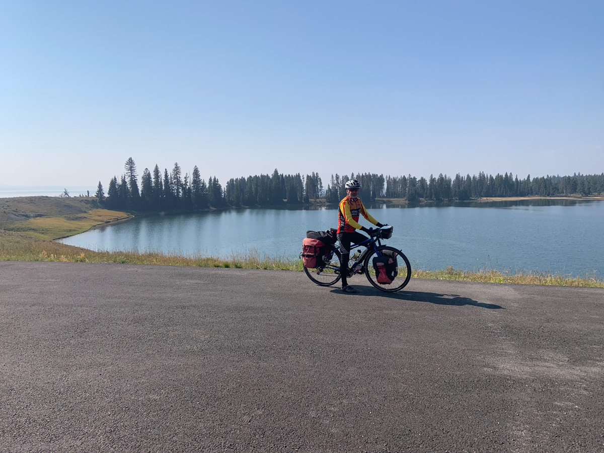
We drove our car to the cabin of a neighbor, about 8 miles west of West Yellowstone, forgoing the thought of taking the bus. Julie and I rode off shortly before 1 PM with the intent of riding 50 miles and 2000 feet of climbing to Canyon campground in Yellowstone National Park. With the aid of a tailwind, we arrived in the hiker/biker site around 6 pm. No shower was available, as showers were turned off in the campgrounds in Yellowstone National Park due to COVID-19. Day 2 was our longest day, 60 miles in 5 hours of riding. We climbed nearly 2000 feet followed by a 2500-foot descent. From canyon campground, only hard-sided campers are allowed in any campground until 16 miles east of the east entrance of Yellowstone National Park at rex hale fs campground. At this time of the year, I had been assured that we did not need weekday reservations for Forest Service campgrounds. Rex Hale FS campground had a friendly host, potable water, and 2 bears close enough to be identified as black bears but far enough to not be threatening to us. We had noticed a lot of bear scat along the road east of Yellowstone. We kept our bear spray close, and our food was in odor-proof bags in a bear box.
The Prairies:
Day 3 was primarily a descent into Cody, the only obstacle being a 3500-foot tunnel without a shoulder. Lights are highly advised. The truck behind us kept his distance and acted like he was our rear escort. The 2 other tunnels are short, perhaps 60 feet at most. Shortly after arrival in Cody we spent 2 hours at the Buffalo Bill Museum, receiving a free return pass after mentioning our return trip to Cody in another 5 days. We then spent the night with a wonderful WarmShowers.org couple, Mike and Paula, outside the city limits of Cody. Days 4-6 were relatively flat rides. We stayed at an immaculately clean KOA in Greybull. Greybull, as legend has it, was named after an albino buffalo, sacred to the Native Americans that lived there. As we moved on to Worland, we stayed at another excellent WarmShowers.org host, Stephen and Susan, north of town. After Worland we rode 40 miles to Thermopolis to an in-town campground next to the main road. Our camp was one mile from Hot Springs State Park where we went swimming in the warm pools. That night we enjoyed a cantaloupe for desert that we carried fresh from the garden of our Worland host. The melon traveled well!
I can’t say enough about our WarmShowers.org hosts. Mike and Paula had ridden across the U.S. on the Northern Tier route in 2016. Stephen rode to his 50th high school reunion in Washington D.C. in 2019, the same year I had my 50th reunion. It is really nice to be with people that understand bike touring and why Julie and I are traveling as we do. As an example, Mike gave me some glue to patch my tubes. When I was patching a tube at his house, I opened a new tube only to find that it had dried out. I barely had enough to patch the tube.
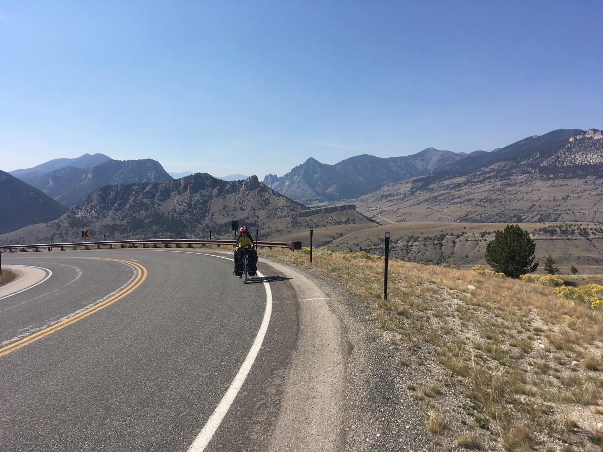
There was a long climb out of Thermopolis at the city limits. We traveled the 50 miles to Meeteetse, where we camped at a respectable RV park on day 7 and additionally had a motel, cabins, and tent sites along the Greybull River. Soon after leaving Meeteeste we encountered antelope in pairs and one herd of about 20 animals. As I sped along looking at the herd, 2 antelope bounded across the road in front of me from the opposite direction giving me a bit of a scare. Further north, Julie and I stopped to see a herd of wild horses grazing.
Though less green compared to Star Valley, Wyoming (Afton, Alpine among other towns) that I have ridden through several times, the plains in this part of Wyoming are also flat, bordered by the Owl Creek Mountain range to the west and the Bighorn mountains to the east. Agriculture, specifically cattle, cattle feed, barley, and sugar beets being the major crops, is a large contributor to the economy along with mining and tourism.
Our return to Cody on day 8 brought us to the Ponderosa campground, about a half-mile from the museum and Wal-Mart where we resupplied. The museum was again a highlight of our return to Cody. If you travel through Cody, the Buffalo Bill Museum should be on your agenda. The museum is a collection of 5 distinct museums comprised of the Whitney Museum of western art (think Charles Russell, Frederic Remington and Thomas Moran among others), The Draper Natural History museum that comprises 5 floors of exhibits with each floor representing a different elevation from prairie to mountain peaks, a museum of Native American history, a gun museum with exhibits going back hundreds of years and of course a museum for William “Buffalo Bill” Cody, one of the founders of Cody, Wyoming. Julie and I spent a total of 4 hours in our two visits, though a minimum of 6 hours is probably a better estimate to really take in the museum. We had previously been to this museum 30 years ago with our boys and before the Draper Natural History was added.
The Peaks:
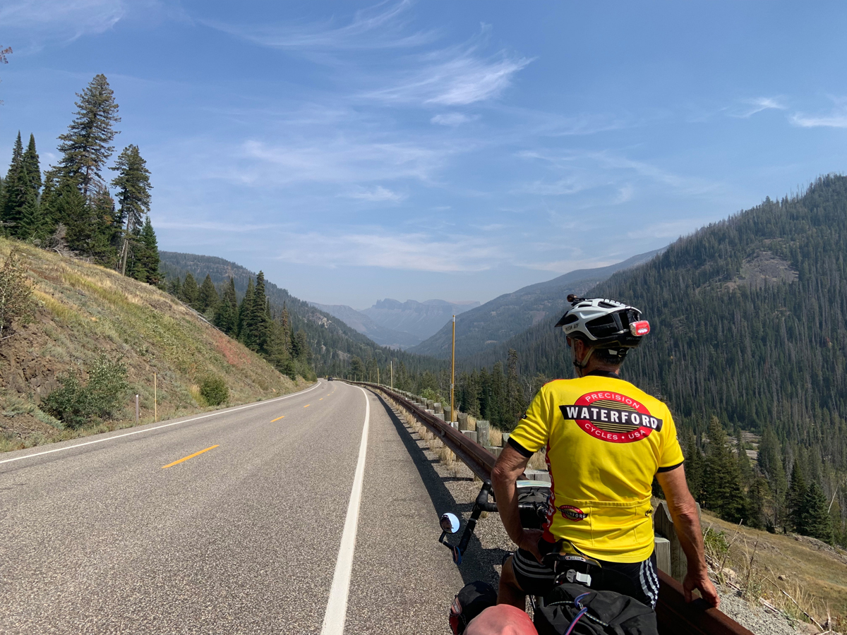
My anxiety again caused me to lose sleep. The next 2 days would involve 78 miles and lots of climbing on the Chief Joseph scenic highway and the Beartooth highway. Given that trucks use the roads, I assumed the grades would be reasonable. I was able to choose to do these mountainous roads, as there is a FS campground (Dead Indian Campground) halfway between Cody and Cooke City, a perfect location that enabled us to comfortably ride to Cooke City in 2 days.
Chief Joseph Scenic Highway lived up to its name. Simply a gorgeous ride rivaling other nationally recognized scenic highways that we have ridden in Utah, Washington, Idaho, and Montana. The highway goes through Shoshone National Forest, following some of the route of Chief Joseph as he led the Nez Perce out of Yellowstone and into Montana in 1877 in his unsuccessful attempt to flee the U.S. calvary.
Fortunately, the smoky skies that limited our views during the first few days of our trip had cleared. We were now able to see mountain peaks far in the distance, multicolored rocks lining the hillsides, and the vegetation that displayed the multiple colors in the cooler September weather.
We arrived at the campground just as the camp host was packing up to leave after a season of hosting. The host told us that we could camp for free. Bear boxes were present, and a ranger came through assuring us that we would be safe from bears. There was one other camper in an RV in the campground that night. On the next day we left Chief Joseph and turned onto the Beartooth Highway. This road was also very scenic, but we had a stiff headwind all day. The Chief Joseph highway has a 9.5-mile steady climb, perhaps a 5% grade topping out at 8,048 feet. The Beartooth had 6 climbs if I recall correctly, but shorter in length. The grades were perhaps 5-7% making for a tough day with the wind despite being “only” a 40-mile day. With the help of a very courteous hotel owner in Cooke City, we obtained the last available room in a cabin in Silver Gate (adjacent to Cooke City).
The Parks:
We left Silver Gate early and entered Yellowstone National Park on day 11 through the northeast entrance. We had a downhill ride most of the morning to Tower-Roosevelt Junction. Riding through the Lamar Valley was another highlight of the trip. The valley has been described as the “American Serengeti”. Hundreds of people lined the road and hillside with spotting scopes and binoculars to watch wolves and bears. Julie and I just saw dots in the distance. We did get to see a few bison herds, with one herd having a rough count of more than 50 bison. After lunch at Tower Junction, we were off to Mammoth. We had several climbs and descents, the last climb taking us to Yellowstone National Park headquarters in Mammoth. We did a tourist walk before heading off to the campground. The elk herd that habitat the area was quite the attraction, especially the one bull elk that walked through the parking lot.
We woke early at the Mammoth campground hoping to beat the traffic out of Mammoth. I grabbed our food from the bear box and heated water though that was going slowly as my fuel canister was near empty and the temperature was around 30. Through the night we heard an elk bugling near camp. As we finished breakfast and cleaned up, the elk, with a 5-foot rack of antlers wandered through a neighboring camp stirring up the dog. Then the elk wandered through our camp close enough that Julie and I prepared to get under the picnic table. The elk decided to lay down behind our bear box. Saying goodbye to the elk, we packed up and left camp.
Upon leaving camp we went uphill for 5 of the first 7 miles. In addition, traffic was heavy with cars. I chose the post-Labor Day weeks in order to avoid crowds but it seemed like a lot of other people had the same idea. Due to traffic, we pulled off the road every couple of miles, especially when we saw a dump truck as it was usually followed by at least 20 cars. About 10 miles or so north of the Norris area a shoulder appeared on the road. Traffic had lightened by this time, and we rode on taking in the scenery. After another short climb we had a small descent into Madison campground. We set up in the hiker/biker campsite and went off to find our neighbors from home. They happened to be camping at Madison so the 4 of us took an hour stroll taking in the beauty along the Madison River.
On our final morning we packed up for the short 23-mile ride while I finished my complimentary mug of coffee from the employee coffee pot in the adjacent camp registration office. We were glad for the short day, as the tailwind we had on day one became a head wind as we exited the park for the final 9 miles to our car. Not only did gusts of wind knock us about, but we also had a rumble strip on the already narrow shoulder and fast truck traffic leaving West Yellowstone making us both nervous.
Overall, the route that we took on this particular trip will be a highlight among the many tours that we have ridden. Julie and I had a wonderful ride. The shorter riding days allowed for a relaxing trip and time to enjoy some of the people and sights along the way.
Nuts and Bolts:
The Salt Lake Express bus drops you of at the Visitor Center in West Yellowstone at 4:50 PM with pick-up for the return trip at 9 AM. You are able to park your car at the Visitor Center for up to 2 weeks. Check with the visitor center for details.
The roads we took had adequate shoulders with the exceptions being Yellowstone National Park roads between Canyon and Fishing Bridge, the Northeast entrance to Mammoth and from Mammoth to about 10 miles north of Norris junction. The roads were actually not bad given the speed limits in the park and courteous drivers.
The weather was great. We had 70-80 degree days in the flat plains (50 for the lows), with 60 plus temperatures in the high country and 30 for the lows. We had strong head and side winds on the day to Cooke City and the day we returned to our car. Winds in NW Wyoming come from the west/northwest. Fortunately, the shortening of our trip by one day turned out to be a good move. Call it good planning; divine guidance or just plain lucky because the temperatures dropped, and Yellowstone had a snowstorm day after we left.
Bring cash as 2 of the campgrounds had “cash price” and a credit card price. We saved a few bucks with the cash price. The campground in Cody (Ponderosa) did not take credit cards and did not have a “cash” discount. Finding a campsite at this time of the year was easy outside of Yellowstone NP. Yellowstone campgrounds were “full”, but the hiker/biker sites were empty for our stays.
We spent about $150 on lodging at 9 campgrounds, 2 nights were spent with WarmShowers.org hosts and $210 for the cabin in Silver Gate, typical of lodges outside of Yellowstone National Park. Full grocery stores are available in Cody, Greybull, Worland, and Thermopolis. Meeteetse has limited groceries at the gas station, Mammoth has limited supplies but there is a café, and in Cooke City we were able to obtain food for a decent dinner and lunch supplies from a hotel grocery shelf. Canyon Village also has a store, but we had enough supplies at that time.
Our 13-day tour was 575 miles, averaging slightly less than 45 miles and 4 hours of riding each day, including the last day when we rode 23 miles to our car. Otherwise, our days ranged from 33 to 60 miles. On day 3 we did nearly 14 mph going into Cody (our high) contrasted with our low of 8.1 mph going to Cooke City.
Cody has a bicycle shop and an outfitter for camp supplies such as fuel. Worland also has a bicycle shop.
Trip Milestones:
This trip has put me within 150 miles (est.) of 25,000 lifetime touring miles, approximately 60% with Julie. We have now entered or exited every entrance station in Yellowstone National Park.
Lou Melini is a lifelong bicycle commuter, tourer, and the former Commuter Column editor for Cycling West.