By Chris Blinzinger — My friend John Monroe and I have been touring around the Intermountain West for the past several years, always looking for an adventure. John and I met on Facebook several years ago after I reached out on a Bicycle Touring page for a touring partner in Utah. He sent me a message informing me that he and some friends had an upcoming trip planned (his second tour). We arranged to meet in Salt Lake City early on the morning of departure, introduced ourselves, and then headed out for a four day tour (my first). We have been on one or two trips a year since then and experienced a wide variety of conditions. For more than a year I had my eye on the Pony Express Trail in Utah’s West Desert as well as a visit to Lehman Cave in Nevada. Another bonus to that area is the opportunity to see the so-called “Darkest Skies in America” due to its lack of light pollution. It was going to be around/about a 350 mile trip. This is close to our normal length of tour that requires minimal days off work while maximizing the time to enjoy the journey. One of the great things about riding with a partner is that we pull each other along when either one of us needs it. John and I have become great friends during our adventures and I value that friendship more each time we head out.
The Pony Express Route
It’s interesting that the Pony Express is such a significant piece of history and Americana that only operated for 19 months. It has much more historical value and gets more recognition for its short duration than some American Presidents. The Pony Express could deliver mail from St. Joseph, Missouri to Sacramento, California in a mere 10 days. 1800 miles in 10 days is far better than we would do on our skinny tire touring bikes. We headed out on a Friday morning from my home in northern Utah County heading west into the Oquirrh Mountains. There is not any direction to ride along the Intermountain West for several days without the need to climb over a few mountains. Immediately after turning onto the dirt road that would lead us across the desert, we stopped at the first of many information signs and monuments that dot the Pony Express route.
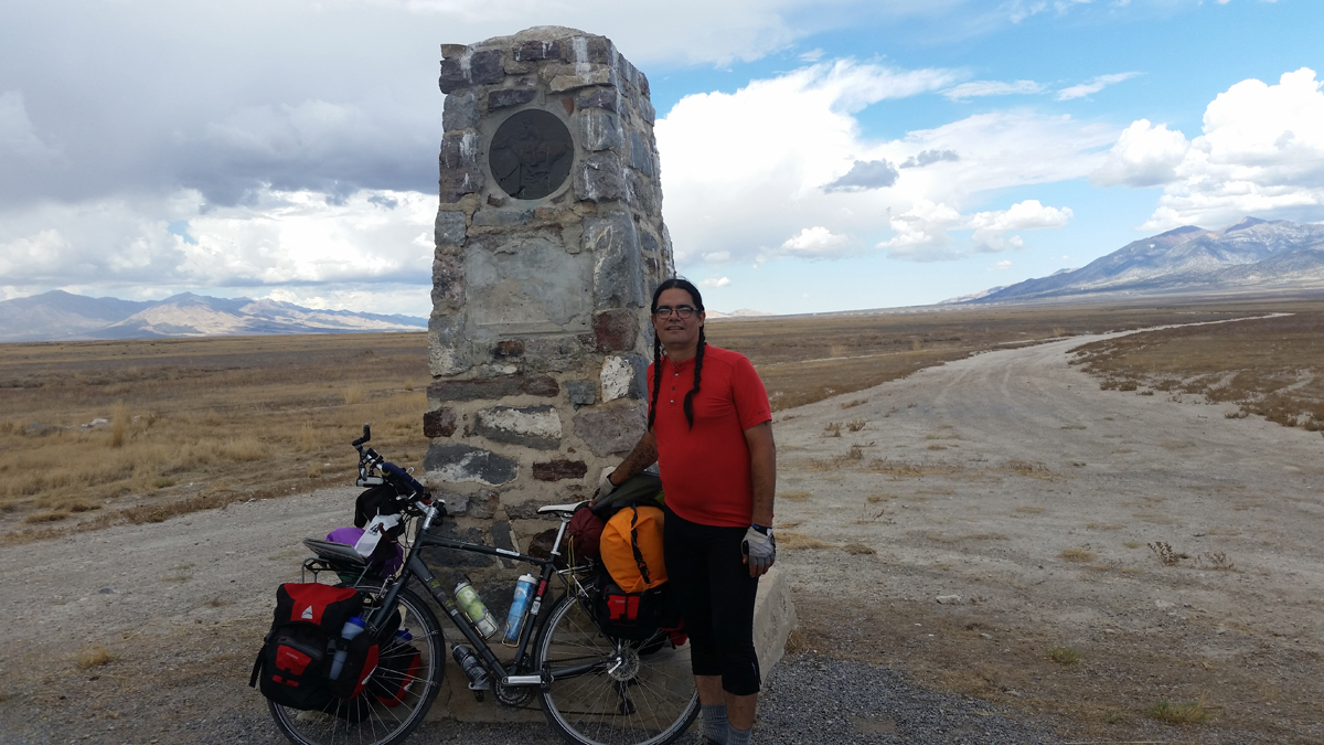
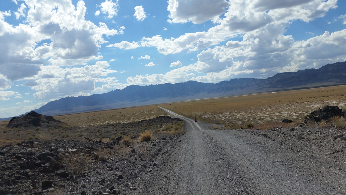
Well on our way out into the Desert, the road was in good condition (hard packed dirt) and provided a historical monument every ten miles or so to signify a Pony Express Stop. Many of the monuments were missing the metal plate with the Horse and Rider, and in disrepair.
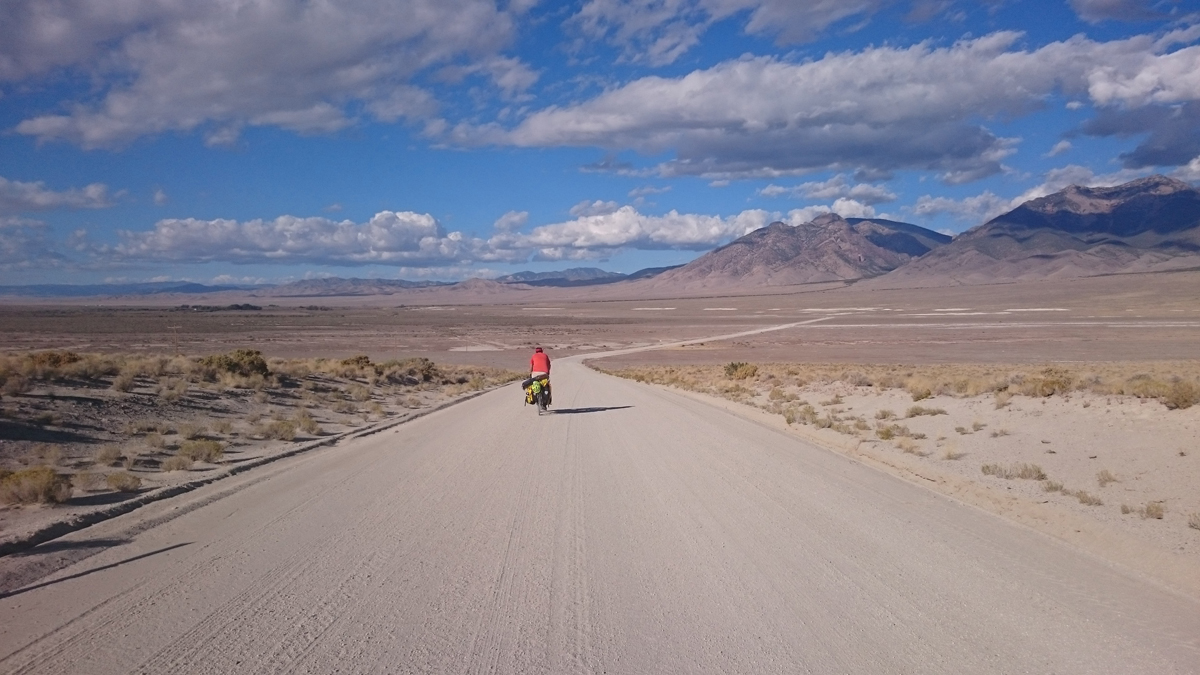
I was amazed at the beauty to behold out there. I expected to see sagebrush and rocks. What I experienced was a large expanse of desert grass, huge blue skies and peacefulness as we rode the long straight roads. It’s hard not to be awestruck with beauty of the desert. We watched a coyote run across the road in front of us and modified our line of travel from time to time to miss snakes in the road soaking up the sun. I imagined those Pony Express riders moving fast across that open space with a trail of dust behind them. We replenished our water at Simpson Springs Campground on the first night. We topped off our water at Fish Springs and turned off the Pony Express route before Callao, UT at the end of day two headed toward Hwy 50.
South to Great Basin National Park
In addition to the large stone monuments dotted along our route, there were 12 inch sections of a piece of railroad rail on a post with a descriptive plate detailing an old trade route or sheep camp. I got the impression from those markers that there was much more activity out there many years ago than the days we were out there. We did encounter a group of motorcycles doing a poker run and other motorists that wondered if we were lost. I always get a kick out of that question when we are out touring. Truthfully, I like it when they look at us like we are crazy. It’s part of the fun.
The road has so many variations of quality in every mile. Some sections are hard packed and easy to ride and pedal while others were sandy and loose and some just had ginormous rocks that are tube killers. It took some skill to avoid them when going downhill. But…there is a 200 foot section of paved road out in Trout Creek. We briefly enjoyed the short lived easy rolling as much as one could. The lone church out there has paved frontage. We stopped for a rest. We took advantage of the shade trees behind the church and sat at a picnic table under the pavilion. We replenished our water supply from a spigot on the pump house and washed up a little. We relaxed there for about an hour enjoying the breeze and plotting the rest of the days ride. It was truly an oasis in the desert.
Soon we were headed out south toward Gandy where we hoped to stop at Warm springs before finishing the days ride by riding into the Border Inn at the Utah/Nevada state line. One hour later we were fighting 35 mph head winds. It was a drastic change from our oasis. Forward movement was slow going so we pulled over under shade and broke into our meat and cheese.
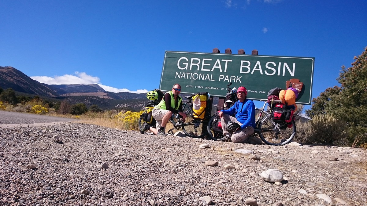
We were there for 15 minutes discussing what to do when a farmer stopped out on the road in his flatbed pickup so we walked over to talk to him. His dog jumped of the truck and ran passed us as we approached. We chatted briefly and swapped a few bike stories (he wants to do what we were doing and asked our opinion on a few things), then he offered us to come to his house 7 miles away to wait out the wind. We decided not to backtrack. While we like flexibility in our schedule, we had pre-purchased tickets for Lehman Cave. There was an annual astronomy event at Great Basin National Park and we followed their recommendation to buy tickets early.
We were concerned that the headwind would slow us down so much that we wouldn’t make it to our scheduled cave tour. Not sounding very flexible. I happened to look over toward our bikes and noticed his dog eating our lunch. He hollered and called his dog over. We shook hands and parted ways and went back to eating what was left of our lunch. We mounted up and continued on. It was tough going and we only managed seven miles in two hours. Wind can be demoralizing. Neither of us was able to encourage the other as we pushed on.
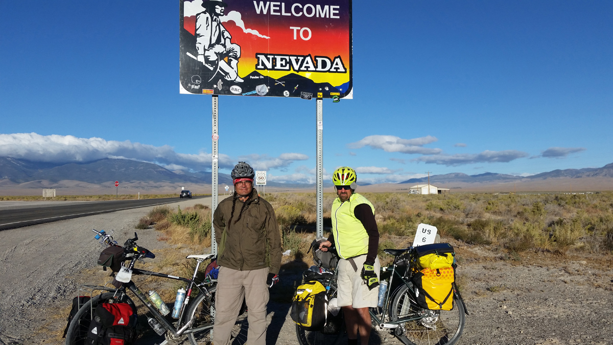
We hesitated to hitch a ride because we were there to ride the whole thing. Well, I heard a vehicle coming up behind us and at the last second, I stuck a thumb out struggling to keep my front wheel straight with one hand. The vehicle hesitated briefly and then I saw brake lights. I pedaled with new energy to see about a ride. The driver asked “Did you flip me off or are you looking for a ride?” I assured him I was looking for a ride. A rancher and his son had been out to check their herd and were headed to the Border Inn. We were in luck and loaded our bikes into their farm truck and hunkered down with our bikes. We passed the turnoff to Warm Springs in Gandy but that was no longer an option with our new found means of transportation. It was 35 miles to the Border Inn. We would have never made it to Lehman without that ride. The winds were supposed to last through the night. We hunkered down there for the night and ate at their restaurant.
To Great Basin National Park
We headed out for Great Basin the next morning. The wind was still blowing and it was much colder. We had a significant climb and planned on camping in the park that night. The climb was brutal, 1700 feet elevation gain with a cold cross wind. We were bundled up like winter commuters. We eventually found relief once we got far enough up the mountain for the hills to block the wind and let the sun warm us up.
The cave was cool. It’s worth the visit. The small visitor’s center has a restaurant for summer visitors. It was already Fall. The climb had really taken our energy so we sought out to find the campground and set up camp. It was easier said than done. When receiving directions it is essential to remember the description is subjective to the informant’s perspective. We know better but I guess we forget. Finally found our camp and enjoyed all you can eat pine nuts everywhere around us.
Our first six miles of the morning were downhill leading us back to the Border Inn. Half way down the hill, we could see something ahead of us at the bottom of the hill on our route ahead that was causing a commotion in the road. It looked strange to us and we couldn’t make out what was going on. Looked like a traffic jam in the middle of nowhere as we could see a line of cars backed up. Once we were two miles away, it was clear what the commotion was but that only resulted in more questions. A two-seater airplane parked in the middle of the road. The pilot landed to chat with driver of a pickup, or just have coffee. They were as surprised to see us as we were them. We all had questions about what the other was doing there. We talked for a few minutes and the pilot loaded up and headed out. How often do you see a plane in the middle of the road in the middle of the desert? Well now I have.
Back to Delta
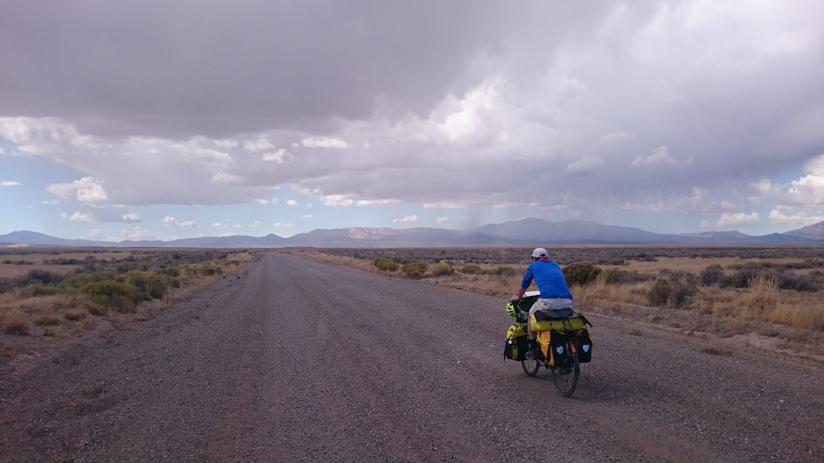
It’s funny how all roads look flat on a map. Our ride toward Delta was hillier than I expected. The pavement was a welcome relief from the 150 miles of dirt road we had been on. We camped close to Sevier Lake ½ mile off of Highway 50/6. I got up in the middle of the night to see a man about a horse, and admired the stars with amazement. From horizon to horizon, there was 180 degrees of bright stars. It was impressive and best view of the stars on this trip so far. We enjoyed a tailwind as we headed east to Delta, then northeast toward Leamington and up over the mountain into Nephi. We rode through some cool little towns on the way to Nephi. We encountered a cross-country female cyclist halfway to Nephi. She started off in Florida for a ride to see her brother in the Midwest but decided to keep riding until she reached the Pacific. I gave her my maps for the west desert crossing. We arrived in Nephi that evening. This is where our trip ended. My wife picked us up in Nephi and drove us home. We lost John’s bike off the bike rack on the way home. We went back and found it but…That’s another story.
Nuts and Bolts
- We left the last week of September. The trip was 351 miles with 10,331 feet of elevation gain.
- We spent five nights and six days on this trip. Every trip is hard and fun and easy and adventurous and thought provoking and rewarding.
- This was a great time of year because days are warm but not too hot and nights were cool.
- John and I have become used to carrying plenty of water. That is probably the most significant consideration for the trip. There are places to get water but you should carry plenty in case you have a problem. I am glad we did it. We carried 10 liters each and a filter. We never had to use the filter.
- It is remote, beautiful and something I can check off my list.
- Baker, Nevada is a ghost town this time of year, businesses are closed up so stock up at the Border Inn if traveling up to Great Basin National Park this time of year. We carry calories, protein and enjoy a hot drink in the morning and after dinner. John made some great dehydrated meals for the trip.
- Meat sticks, trail mix and Hudson Bay Bars (homemade oat bars) are easy to access while riding and we never pass up a convenience store.
- The route along Highway 50 is wide open, but camping can be difficult because of the fence that parallels with infrequent gates and side roads.
Now we are talking about doing the Loneliest Road in America through the rest of Nevada. But first we will ride to Grand Junction in June.
Chris Blinzinger is an Emergency Manager and avid cyclist living in Pleasant Grove, Utah. He traded in his horses for two wheels over a decade ago and is now a regular bicycle commuter/tourist.
We spent a week in Baker, NV in August 2020. The town and Great Basin park are excellent. However, the grocery store closed sometime in 2020. It’s for sale, and no idea when or if it will re-open. The closest store is now in Ely, NV 63 miles north. Bring everything you need. The small motel in town has a couple coolers where you can buy milk, beer and even ice cream. There is a good restaurant. It is open like Thursday to Monday, but check first. There’s also a great espresso stand, open every day, which also has breakfast burrittos. An added bonus is that you are likely to meet both the Mayor and Sheriff of Baker while you are getting your coffee. You’ll have to go there to find out for yourself what I’m talking about.
I noted your plans in riding “the loneliest road in America”. We drove from Tacoma through Lassen Park, then Reno, and followed US 50 across Nevada. There are 17 mountain ranges between Fallon and Baker. That’s not so bad, as I love to climb mountains on my bike.
But, we found the road was not “lonely”- we always had vehicles in sight. It may have been due to the pandemic, but we were surprised at the amount of traffic. There are also several sections of US 50 that do not have a shoulder, and traffic moves along at 80 mph.
Maybe there’s a gravel alternative? Or at least options to avoid cycling on US 50, as I wouldn’t recommend it (and I ride over 7,000 miles a year, and rode in Beijing, China for many years- but they had wide bike lanes).
Good luck!