10 Foot Travel Lanes Would be Safer For Cyclists, Pedestrians, Wildlife, and Motorists
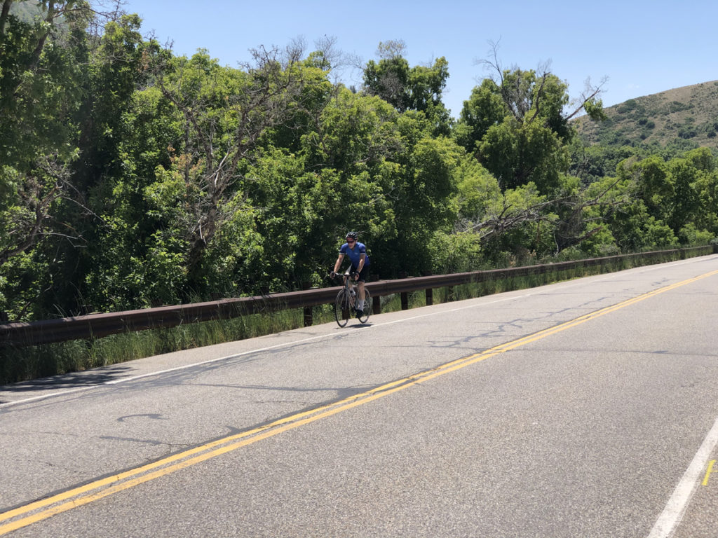
July 7, 2020 – Emigration Canyon in Salt Lake County, Utah is currently being reconstructed from Donner Monument to SR 65 (the road to East Canyon). While cyclists have been concerned about the short term lack of access to the canyon, the problems with the roadway design have far greater long term consequences for cyclists’ safety.
The current plan is to keep the road striping the same as it is now, with mostly 12′ wide travel lanes from the Salt Lake County line to approximately the Fire Station, 11′ foot lanes from there to the Pinecrest turnoff, and 12′ lanes to Little Mountain Summit, and finally 11′ lanes from the summit to SR 65.
More on the striping plan is below, this from the Emigration Project Team:
Concerning the new striping and lane widths, here is the planned layout.
- From the County line to the Fire Station in the eastbound (uphill) direction there will be a five (5) foot bike lane. Twelve (12) foot travel lane to Skycrest. Eleven (11) foot travel lane from Skycrest to the Fire Station.
- From the County line to the Fire Station in the westbound (downhill) direction it will remain “Share the Road”. Twelve (12) foot travel lane.
- Between the Fire Station and Pinecrest it will continue to be “Share the Road” because there is insufficient room through that section to strip for bike lanes. Eleven (11) foot travel lanes in both directions.
- Between Pinecrest and the Summit there will be five (5) foot bike lanes on both sides of the road. Twelve (12) foot travel lanes in both directions.
- From the Summit to SR-65 once again it will be “Share the Road” because of how narrow the road is. Eleven (11) foot travel lanes in both directions.
We very much wanted to expand the bike lanes, but the project simply was not funded to be able to add the width necessary to support additional bike lanes. Travel lanes were only adjusted where necessary to provide five (5) foot bike lanes.
Why are lane widths important? Road design, and in particular lane widths, impact the speed at which motorists feel comfortable driving. According to Jeff Speck’s Walkable Cities Rules, 12′ lanes have a design speed of 70 miles per hour, while 10′ lanes have a design speed of 45 miles per hour. The speed limit in Emigration is 40 mph. So, why are 12′ lanes specified?
We asked this question of the project engineers, and they indicated that the leadership of Emigration Township did not want this. We are unclear on the reasoning here.
The new Township encompasses one of the most beautiful areas in Salt Lake City, where hundreds of cyclists and tourists ride and sight see. The canyon is also the site of Brigham Young’s Last Camp, prior to declaring “This is the place!” in the Latter Day Saints journey west.
According to Strava data, it is likely the 4th most popular recreational bike route in the country, and the most popular in Utah.
In the Salt Lake City section near the mouth of the canyon, there are adequate bike lanes, although we would like to see narrower travel lanes here, and wider bike lanes, this section is not part of the reconstruction. We do plan on asking Salt Lake City about this.
In the Salt Lake County section, there are really no true bike lanes, but rather just wider shoulders. Riding up the canyon, having adequate room is paramount to cyclists’ safety as the speed differential between cyclists and cars is much higher. 10′ lanes would provide in some sections 1 to 2 more feet of space to ride. Additionally, this provides more room for pedestrians. We would think that one of the desires of canyon residents is to be able to walk along the road safely, with enough room to not get buzzed by car traffic.
In the downhill direction, there are some parts of the canyon where cyclists can reach 30-35 miles per hour, and can easily take the lane. However, there are many sections in the canyon where cyclists cruise along at lower speeds, and generally will want to ride in the shoulder / ‘bike lane’.
A wider shoulder and narrower travel lane would give more room for cyclists to ride, and would lower conflict between motorists and cyclists.
Additionally, in a conversation with one of the Unified Police Department officers that patrol the canyon, they stated to us that motorists in speeding vehicles are one of the main issues that they deal with. Narrower travel lanes by design reduce motorist speeds. This is better on many levels. It would reduce enforcement issues. Slower motorist speeds would reduce the speed differential between cars and cyclists, thus reducing conflict. And, slower motorist speeds would reduce crashes with wildlife.
We would offer specific recommendations as to where to go to 10′ travel lanes, but despite several requests, Salt Lake County would not respond to requests to share the striping plan with us. Additionally, as far as we are aware, no cyclists were contacted for feedback on the current plan.
The 2015 Emigration Canyon Roadway Improvement Committee study (ECRIC study) recommends, “Meet or exceed AASHTO standards regarding road
widths, bike lanes and road shoulders.” But, as far as we can tell, the study is silent on vehicle travel lane widths. The only way to gain more width for bike lanes and road shoulders without widening the road (which is difficult because of cost) is to narrow the travel lanes.
The study contains a number of other recommendations. We are not able at this time to tell which of those will be implemented.
All in all, the striping plan in Emigration needs to be reevaluated as soon as possible and needs to take in to consideration modern road design standards that will result in safer conditions for all canyon users and residents.
[Note: Cycling Utah does plan on sharing this editorial with Emigration Township.]
[Note: To send in comments on the project, email the project team: [email protected] and [email protected]]
To contact Emigration Township with comments, see: https://www.ecmetro.org
I am not a traffic engineer, so speaking about specific traffic calming elements might not be pertinent for me to make specific comments. The use of certain widths and geometric designs depend on more than a single variable and it requires professional discretion in how best to implement them. That said, there are guidelines that should be followed as closely as possible, and then with the use of professional discretion utilize exceptions that improve the safety and mobility of all users of the road. Has the team heading this project offered reasonable justification for their design?
I would ask, has the team followed the latest FHWA Bikeway Design Selection guidelines, and if so, how do they justify the use of the current design if it is different or does not meet the goals stated in those guidelines? Since it is a project that resides in Salt Lake County, does this design meet the County’s Bikeway Best Practices guidelines? If not, then why not?
Everything here makes sense to me. But it seems to imply a call to action. What is it? Is there a petition out there? Is there a group already engaged in discussion? Or is this just an editorial saying something needs to happen?
Wayne, to send in comments on the project, email the project team: [email protected] and [email protected]
Contact information for Emigration Township’s mayor and council is here:
https://www.ecmetro.org
I have a copy of the striping plan. I have been talking to the county folks and the project management firm. The next step for me is the review the striping plan and then request a open public meeting to address cyclists concerns.
Dirk, this sounds like a great idea. Please keep us posted about what you find out.