dogged me for a couple of days were gone by the end of the day.
By John Roberson
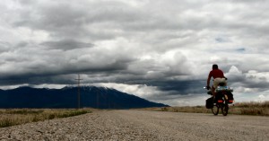
I awoke early one June morning to the gentle sounds of larks flitting about in the surrounding sagebrush and of a light rain falling on the fabric of my tarp shelter. I twisted around in my sleeping bag for a view to the south and saw low-level stratus clouds and a fresh dusting of snow on the highest slopes of the Pilot Range. I found myself wondering, “What kind of a desert is this, anyway?” I was camped on the northern fringes of the Great Salt Lake Desert, and I was just beginning the third day of an eight day bicycle tour of the west desert regions of Utah and Nevada.
On the previous Saturday morning I had managed an early start from my house in Salt Lake City. I was anxious to leave the sights and sounds of the city behind me, so I hitched a ride to Ogden on one of our delightful commuter trains. By the middle of the morning I was riding north along U.S. Highway 89 under cool, cloudy skies. The road was quiet, and the excellent shoulder allowed me to settle into my load and to think a bit about what might lie ahead.
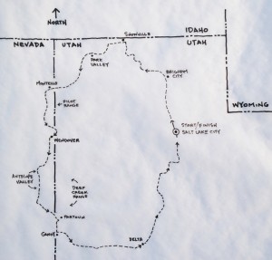
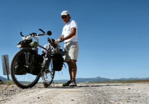
It was my intention to work my way around the Great Salt Lake Desert in a counter-clockwise direction. I hoped to revisit some familiar routes and see some parts of the state I had never seen before. I had no set route in mind, and I had the time to do a bit of wandering along the way. I was traveling with a fairly light load, but I had everything I thought I might need to handle the remote regions I knew I’d soon be facing. I’d be traveling on paved roads at times, but much of my riding would be on the non-paved roads that crisscross our deserts and mountains. I had plenty of food and equipment and enough water-carrying capacity to get me from one isolated water source to another. I was comfortable, confident and definitely excited by my prospects.
After a leisurely lunch break in Brigham City, I headed west through Corinne and on towards the Golden Spike Monument at the north end of the Promontory Mountains. Here and there, among the shoreline terraces left by Lake Bonneville, I could see traces of old railroad grades from the 1800’s. I found myself wondering what it might have been like to work on a 19th century railroad crew. Despite the lovely setting, it would certainly have been a demanding life.
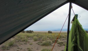
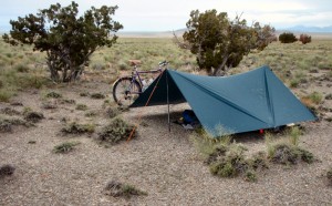
I left the paved road near the Golden Spike visitor’s center and turned north and west along well-graded roads that skirted Hansell and Sage Valleys. I spent the rest of the late afternoon and evening rolling slowly along and enjoying the solitude and exquisite vistas that opened up over each rise and around every turn in the road. Birds flew about and wildflowers bloomed along the roadway and in the meadows. I made my initial camp on a low, grassy ridge as the setting sun’s rays hit me for the first time that day. I pitched my tarp, savored a hot-toddy and a Mary Jane’s freeze-dried meal, then settled into my bag for a restful sleep.
Day 2
After breaking camp the following morning I continued riding north on dirt roads to the small community of Snowville. I had a tasty breakfast at Mollie’s cafe, watered-up, then carried on to the west along Utah State Highway 30. The skies were clearer that morning, but a slight headwind had developed. I dropped into a lower gear and slowly crossed the northern reaches of Curlew Valley. It was a beautiful Sunday morning, and the traffic was very light, so the winds I faced seemed a minor inconvenience. I reached Curlew Junction by mid-morning, then turned south following route 30 as it skirted the eastern and southern slopes of the Raft River Mountains.
The winds had mellowed by the time I passed through the quiet communities of Park Valley and Rosette, and as route 30 gradually turned to the south, I found I had a nice little tail wind to push me along. For the next couple of hours I enjoyed views of the northern reaches of the Great Salt Lake and desert. But the afternoon eventually turned to early evening, and the clouds that had been quietly building throughout the day began to throw down a light, misty rain. The rain was actually very pleasant, and I might have kept riding for a while longer, but I left the highway at the southern tip of the Grouse Creek Mountains and made camp for the evening. I pitched my tarp, and settled in for what proved to be very comfortable evening.
Day 3
The light rain that greeted me on that third morning had stopped by the time I finished my morning coffee and breakfast. I took my time loading up, then worked my way back down the slope to the paved road where I continued on along route 30 to the west. Morning clouds still hung about at the tops of the various mountain ranges to the north and south, but the paved road surface had dried, and the sun gave the impression of having decided to come out for good.
I had thought that I might leave the paved roads at Grouse Creek Junction and ride south along the eastern edge of the Pilot Range. I wanted to see the Sun Tunnels and what was left of the old community of Lucin, but the dirt roads at the junction were still pretty wet from the previous week’s rains. I’m not a big fan of the mud, so I decided to carry on further to the west. I crossed into Nevada and rode into the small railroad community of Montello where I had a hot lunch at a local bar and grill. I watered-up again and rode south a few miles before finally leaving the paved road for a very nice, graded county road.
The county road was dry and the riding was easy, and I was reminded again of the myriad pleasures of riding on dirt roads. The pace is slower, of course, so motorized traffic is lighter. But the slower pace also makes it easier to observe all those interesting things that go on at the edges of roadways. There are animals to see, intriguing rocks to inspect, occasional treasures to be found, and endless, open vistas stretching out in every direction to enjoy.
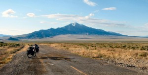
On this day the Pilot Range dominated my views to the east. A layer of clouds hung among the snow-capped peaks, but the skies to the south and west were clear and promising. I spent an easy afternoon riding south, passing ranch gates and meadows, and a handful of cars, then turned and climbed east to a low pass at the southern tip of the Pilot Range. As the evening sun settled onto the western horizon, I made a camp with a view among the sage and grasses, and within yards of the Utah/Nevada state line. I pitched my tarp to dry, but sat out in the open as I went through my evening rituals, all the while enjoying stunning views of the Pilot Range to the north and the expanses of salt flats to the east.
Day 4
I awoke to clear skies and the sun rising above the Great Salt lake Desert. All traces of the previous day’s clouds had disappeared, and I was thrilled to think that perfect early summer weather seemed to be the order of the day. I loaded up and made the short ride over Leppy Pass and on into the glamorous community of West Wendover, Nevada. I rolled through town, thanking my lucky stars that I didn’t have to spend this beautiful day in the windowless confines of a casino. I hit the Smith’s store at the west end of town for a few groceries, water, and a second breakfast. I knew I wouldn’t see another grocery store until I arrived in Delta, Utah, in a few day’s time, so I took some time to consider my needs.
Over the years I’ve developed an eating routine that works pretty well for me, although it does vary a bit, depending on the season and the availability of supplies. My breakfasts generally consist of instant oatmeal packets fortified with lots of dried fruits and nuts. My end-of-day meals are most often based on a hefty, freeze-dried meal, supplemented with nuts, crackers or bagels, and a bit of cheese. During the day I drink a lot of water, munch on a Probar or two, and snack from a bag of “trail mix” of one kind or another. A trip through less-remote regions might mean more restaurant meals and fewer “self-supported” items, but this trip wasn’t one of those.
I left Wendover near the middle of the day and rode south on U.S. Route 93. Traffic was light, and I was delighted to find I had a gentle north breeze to push me along. The weather was wonderful, and I frequently stopped to admire the sweeping vistas that are so characteristic of our Great Basin deserts. Once I crossed White Horse Pass I left the main highway to check out an interesting piece of old, abandoned roadway that paralleled 93 for a mile or so. It had been encroached upon over the years by sagebrush and grasses, and it was barely passable, but it led me to Nevada County Road 33, where I left the pavement and headed south into Antelope Valley.
It was late afternoon by this time, and the shadows from the mountains to the west were beginning to make their way across the open valley. There were no trees anywhere, but the rich valley grasses were green and soothing to my eyes and spirit. I knew, though, that the colors would fade as the summer matured. Antelope Valley would be a less attractive place in a few weeks, but for now, it seemed almost magical. Traffic was non-existent, but there were horses off in the distance, and I had to slow for cattle now and then.
At one point in my ride, very near the end of the day, I came across a small pond and livestock watering tank, fed by a free-flowing pipe. The water looked pretty good, so I decided to make my camp on the open slopes, a few hundred yards above the tank, with plans to revisit the tank in the morning. I spread my groundsheet, threw down my pads and gear, and settled in for the evening. From my cozy perch I had great views of the valley and of the snow-capped Deep Creeks, to the east. The breezes of the afternoon had subsided, so I was able to tune in to the end-of-day sounds of the valley around me: the trilling of meadowlarks, the lowing of distant cows, and the howling of coyotes getting ready for their evening adventures. A couple of horses came close to investigate, and an owl flew a couple of silent circles around my camp. It was a wonderful evening, and I slept like a baby.
Day 5
I found another beautiful day waiting as I awoke the following morning. I watched it “come alive” as I slowly worked through my morning rituals. After loading up, I returned to the water tank and filled my bottles with delicious, filtered water. I was carrying about 6 liters in water capacity, so this process can sometimes take a while. I only had a couple of liters to fill, so I was finished in a flash. I continued riding south on county roads until I came upon a junction marked by the remains of a few stone buildings, and an old stone dam that held back a small, but vibrant body of water. It was a little oasis. Birds were busy among the cattails at the edge of the reservoir, and low trees and scrub lined the outer edges of what seemed a semi-permanent water source.
I turned east at this junction and crossed Antelope Valley along Nevada County Route 35, then began to climb into the Kern Mountains, by way of Tippet Canyon. The grade was fairly easy, but it still took me several, leisurely hours to reach the summit, at about 7,000 feet. It was the highest point in my trip so far, and I took an extended break to relax. There were imposing granite peaks, and carpets of flowers in the meadows, and at the edges of the road. I stopped to top off a bottle from a free-flowing stream, then spent much of the afternoon cruising easily down through aptly-named Pleasant Valley, past small ranches and homesteads, then on to the Utah state line.
It was late afternoon when I encountered a major, graded road just south of Partoun, Utah. It was there that I met a road-grader operator named Earl. He was the first person I’d seen since leaving Wendover, and we ended up having a lengthy, and very pleasant, conversation. I got some solid advice about water sources and road conditions to the east, and he filled me in on all the latest goings-on there in Snake Valley. He was a nice guy who seemed entirely at ease living and working in what others might see as a remote and unforgiving environment. I left Earl and rode south into a pretty serious headwind. It was hard work, and I spent a grueling hour traveling a mere handful of miles. I pulled a bit of water from an irrigation ditch at a road junction just north of Gandy, Utah, then turned east onto another graded road. I rode my last few miles of the day, then set up another excellent camp on the gentle slopes above the road.
Day 6
The next day’s weather was mixed. The morning sun shone brightly, but a south breeze had begun to build again, and I began to think about the possibility of a change in weather. I lingered as I watered-up at Foote Reservoir, a delightful, permanent oasis there in the desert flats, not far from my camp. Earl had told me about the lake. I then began to work my way slowly south and east, aiming toward the Confusion Range and Cowboy Pass. The south winds stiffened, and my progress through the morning hours was slow. I made the pass, then dropped into Tule Valley along the Marjum Canyon Road. This dry-lake valley had none of the vibrant green colors that I had found so soothing a few days earlier. With the steady winds and blazing sun, and the prospects of a nasty climb over the House Range, I was beginning to feel a bit ragged. But the mountains were there, stretched out in the distance before me, and I had to find my way up and over before I could call it a day.
To my delight I found the road that wound through the House Range via Marjum Canyon to be quite nice. I was sheltered from much of the wind that blew through the open valleys, and the pass itself turned out to be less severe than I had remembered. However, during my late-afternoon climb, the weather had changed. The warm south wind had turned to the north and high clouds had moved in. I found I was facing a rapid drop in temperature along with the change in wind direction. I bundled up at the summit before riding off the eastern slopes of the House Range, in the general direction of Delta, Utah. I camped at dusk on a piece of desert hardpan away from the road, with a small cluster of brush to the north to block the wind. I pitched my tarp, anticipating the worst, then settled in for a breezy and rather chilly night.
Day 7
By morning the winds had died and the desert sky was brilliantly clear and fresh. There was a bit of frost on my gear, but it melted off with the first rays of sunshine. I broke camp and continued east on graded road to an intersection with U.S. Highway 6-50. The paved road was a refreshing change from the dirt roads of the previous few days, and the ten miles or so of smooth highway to Delta passed with ease. I stopped at a grocery store in town and considered my remaining supplies. I was essentially bound for home, and I knew I’d be traveling through relatively “civilized” terrain, so I refrained from loading up on supplies I wouldn’t need. Ideally, at the end of a perfect tour, I would roll up my driveway with empty food bags.
After a lengthy break amid the relaxing greenery of the city park, I rode north and east out of Delta on U.S. 6. The day’s weather was simply marvelous, cool and refreshing, and the riding was smooth and speedy. The traffic was light, the highway shoulders were wide, and the motorists who passed seemed especially careful and considerate. I took a short break in Lynndyl to watch a few trains go by, then carried on to the north past the Little Sahara sand dunes and Jericho Junction. As the late afternoon sun began casting shadows over meadows and pastures, I left U.S. 6 for Utah State Road 36. This quiet, rolling highway led me to the northwest through lovely, green countryside. Unfortunately, much of this pastoral beauty was marked by fences and no trespassing signs. After some last-minute scrambling, I found a decent place to hunker down at the top of a road cut near a minor summit. I set up what would be my last camp of the trip. The site didn’t have much of a view, and I failed to note a side road that crossed an active railroad line. As a result, I was awakened periodically during the night by the unmistakeable sounds of train horns at the crossing. Other than that, and a brief visit to my camp by a barking dog, my dreams were pleasant enough.
Day 8
be back in the Salt Lake Valley by early afternoon. I’m taking it easy and enjoying a perfect morning. The solitude is sublime.
The weather on the final day of my tour was picture-perfect. The sky was a brilliant blue and the air was calm, clean and cool as I rode from my camp at the summit into the south end of Rush Valley. I left the paved road again and took a dirt road that bee-lined to the north along the western edge of the East Tintic Mountains. I hit paved road again at Five-Mile Pass, at the south end of the Oquirrhs. I took another restful break under the trees in the old Camp Floyd cemetery, had a cold drink in Cedar Fort, then skirted the north edge of lovely Cedar Valley.
By this point in the trip I had returned to the hustle and bustle of the city, and I was anxious to get through it with the least amount of fuss. The new commercial and housing developments at the north end of the Lake Mountains were a nightmare of busy roads and harried drivers. The conditions required a level of serious focus I hadn’t really needed for a while. I worked my way east to Redwood Road, then headed north. Despite the ever-present traffic, the newly-widened shoulders of Redwood Road made the ordeal considerably less stressful than it might have been. I picked up the Jordan River Parkway at about 90th South, slowed my pace, and savored what remained of my excellent adventure.
As I wound my way along the river’s edge, I found myself thinking, as I often do as a tour winds down, of the amazing variety of options available to bicycle riders here in Utah. I think about all the side roads I might have taken and all the perfect campsites I passed. I think about how a particular place might look in another season, and I wonder about the symbols on my maps that suggest treasures and adventures to be explored. I constantly wonder that I don’t see more tourers out there exploring our beautiful countryside. It really isn’t very hard. It takes a bit of planning and a basic level of fitness, for sure, and there are times when you might wish you were somewhere else. But the experiences are always memorable for me, and I finish up every trip with ideas about the next one forming up in my imagination.