cycling utah September 1999
Click here for a Topo Map of this, and past trails of the month
Fall is perfect for Flaming Gorge
Little Hole National Recreation Trail, Excerpted from Mountain Biking Utah revised 2nd edition
By Gregg Bromka
Don't let Labor Day's "Sniagrabs" fool you into thinking its time to stuff away your bike and wax your skis. On the contrary, autumn is a wonderful time of year for mountain biking with its cooler temperatures and stunning fall colors.
And September is the right time to head to Flaming Gorge to ride the Little Hole National Recreation Trail along the Green River.
"Why wait," you say? That's because the trail is closed to bicycles from April to September to allow uncontested river-side access for the large numbers of anglers. Your patience will be duly rewarded when you ride the fun-loving trail along the banks of this blue-ribbon hatchery. Pack along a pole and hook your quota of trout, or try to snatch one barehanded as schools team up in the calm bank-side eddies just a few feet from the path.
The route begins at the base of the colossal concrete slab of Flaming
Gorge Dam. As you sneak away from the monstrosity of water retention, it's just you, the Green River, and Red Canyon's 1,000-foot-high stone ramparts. John Wesley Powell floated these gentle rapids in 1869 as he embarked on his legendary expedition to the Grand Canyon. You'll shadow rafters who are content with replicating only a fraction of the journey.
Notes on the trail:
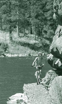
Right from the start, the quirky Little Hole Trail tests your bike handling skills as you negotiate scattered boulders, roots, and dips in the tread. This is the fare for the day: smooth dirt tread interrupted with things that make you go bump. Early on, the canyon's terraced maroon-sandstone walls close in tight on the trail and attempt to nudge from the narrow path into the drink. Watch your head as you brush by, and focus on where your wheel should be-not where it shouldn't be.
Periodically the trail crosses "gabions," where the tread has been fortified by rocks caged by wire netting to prevent erosion during high water flow. The elevated 4-foot-wide rock-and-wire path bucks you around, and you need good balance to roll over the rough surface. The slower you ride, the harder it is to stay upright. All these precautions and pesky trail conditions may sound troublesome indeed, but if you stop periodically you'll become captivated by colorful cliffs, rushing river, and lush riparian growth.
A few miles down stream, the path crosses a wooden boardwalk alongside overhanging cliffs. Between miles 4 and 5, the trail rises uphill sharply to a vantage point 150 feet above the river then descends to a crescent-shaped sand beach on a river bend a mile farther. Continue alongside the river over smoother conditions until you reach Little Hole, where Red Canyon's towering walls have subsided to grassy fields on opposing banks.
To avoid the required car shuttle you have two options: Ride out-and-back or pedal paved roads for a 17-mile loop. If you choose the former, novice riders will find the gentler trail conditions starting from Little Hole (trail end) more to their liking. Starting from the spillway trailhead is more scenic but technically more difficult.
For the loop version, circle back to the dam on the paved Little Hole road. You'll face two long-winded climbs along the way, each about 1 mile long and gaining nearly 1,000 feet total. When you reach the T junction just past Dutch John, turn left on UT 191 to return to the dam.
Most of the route crosses rolling hills populated with fir and pine. The last half mile, however, is an eyeful where the roadway curves high above the dammed reservoir and ends with a speedy descent back to the spillway trailhead.
Want to know more about Flaming Gorge? Here are the "dam" facts.
Construction of Flaming Gorge Dam began in 1958 and was completed in 1964 at a cost of 65 million dollars. It is one of four units on the Colorado River Storage Project that produce electricity for the Intermountain West.
Rising 502 feet above bedrock, with a base thickness of 131 feet and a top thickness of 27 feet, the dam impounds the Green River to form Flaming Gorge Reservoir, which extends 91 miles to the north and into Wyoming. The roadway across the dam's crest is one-quarter mile long. Nearly 1,000,000 cubic yards of concrete were used to build the dam, and its 3 turbine-powered generators can produce a maximum of 150 megawatts. That's a lot of lumens! Guided tours offered at the visitor center take you deep within the dam to view the power plant.
Just the facts:
Distance: 7 miles point-to-point.
Tread: Dirt and rock singletrack.
Physical difficulty: Moderate. The path follows the banks of the Green River, but there are numerous bumps that require surges of power, plus there is one steep but short climb midroute. The technical aspect of the trail consumes more energy than the ups and downs.
Technical difficulty: Moderate. The Little Hole Trail is not maintained for bike traffic, so you can expect the three Rs: rocks, roots, and (e)roded tread. Occasionally the narrow, rock- studded trail is wedged between cliffs above your left shoulder and the river's banks below your right foot. Good balance is required to stay on the straight-and-narrow.
Several sections cross "gabions" where the tread is a caged-in row of rocks. Portions of the trail can be overgrowth and thus conceal many surprises awaiting your front tire.
Elevation change: The spillway trailhead is at 5,620 feet. The trail descends to 5,530 feet at Little Hole, which makes for a near level ride. However, a midroute climb gains about 150 feet.
Finding the trail: From Vernal, travel 36 miles north on US 191/UT 44 and ascend the eastern Uinta Mountains. Turn right on US 191 for Flaming Gorge Dam and Dutch John. Cross the dam after 6.4 miles; then 0.4 miles farther, turn right at milepost 282 for "River Access." The trail begins at the boat ramp next to the outhouses.
Some fine print
The Little Hole Trail is closed to mountain bikes from April 1 to Labor Day. Autumn (after Labor Day and through October) is the best time of year, although you might be able to sneak out during early spring (mid-March) because of the trail's relatively low elevation.
A recreational use fee is charged within the Flaming Gorge National Recreation area. A pass can be purchased from the Forest Service district offices, visitor centers, or most businesses in the region, and it must be displayed on your vehicle.
 Back to Home Page