By David Collins — This month marks the 150th anniversary of the first transcontinental railroad. On May 10, 1869, the final spikes were pounded into place near promontory Utah completing the first coast-to-coast railroad. Three of the four ceremonial spikes used that day are currently on display at the Utah Museum of Fine Arts on the campus of the University of Utah.
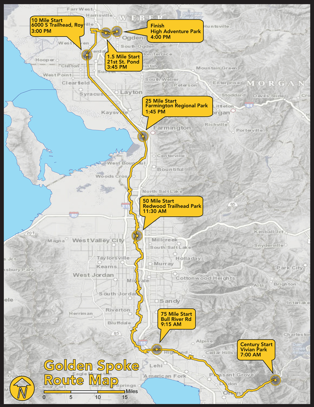
Looking for a great century ride to commemorate the occasion? Try the 106 mile paved urban network of trails called The Golden Spoke. It’s a safe way to ride through the heart of the Wasatch Front.
Route: Begin at the Provo River Parkway at Bridal Veil Falls in Provo Canyon (Hwy 189) to the mouth of Ogden Canyon with a quick 15 mile detour into downtown Salt Lake City and up to the University of Utah. 121 miles.
Terrain: A taste of alpine canyons, waterfalls and famous fly-fishing river shorelines, wetlands, but primarily—paved trails through the heart of cities of the Wasatch Front including, Provo, Orem, Lindon, Pleasant Grove, American Fork, Lehi, Bluffdale, Draper, Riverton, South Jordan, West Jordan, West Valley, Salt Lake City, Bountiful, Centerville, Farmington, Kaysville, Layton, Clearfield, Sunset, Roy, West Haven and Ogden. If that seems like a lot of cities, you’re right. The ride links several paved trails (including the Provo River Parkway, Murdock Canal Trail, Jordan River Trail, Legacy Trail, Denver & Rio Grande Rail Trail and the Ogden River Parkway).
What to See: A slice of life along the Wasatch Front (home to about 2 million residents); International Peace Gardens; river shorelines-Provo, Jordan and Weber; towering Wasatch Mountains to the east and sparkling lakes to the west—Utah and Great Salt Lake; Great Salt Lake Legacy Nature Preserve; Farmington Bay; WWII US Navy mapping agency—now an industrial park called Freeport; the Salt Lake City headquarters campus of the Church of Jesus Christ of Latter-day Saints (including their iconic temple); The Cathedral of the Madeleine; the 2002 Winter Olympics Opening Ceremony stadium at the University of Utah.
Selfies and Photo Ops: Bridal Veil Falls; gullies around the point-of-the-mountain; 2002 Winter Olympics sidewalk art and Opening Ceremony stadium at University of Utah; Cathedral of the Madeleine; Salt Lake City Temple; Farmington Bay views of Antelope Island, Ogden Canyon waterfall (about a half a mile east at the end of the ride—in the mouth of Ogden Canyon).
Wildlife: Songbirds, birds of prey, migratory birds, waterfowl, muskrats, deer, coons and similar carpetbag size creatures, urban squirrels and chipmunks, game fish, field mice and other little critters.
Best Post Ride Eats: Timbermine Steakhouse in Ogden. The ride ends in the parking lot and convenient enough, some of the best meats in Utah are served inside with all the sides you’d expect from a good steakhouse. Be sure to get the Timber Pie for dessert, it’s some kind of ode to the chocolate chip and it comes with tasty cold ice cream on the side, a perfect way to end a long day in the saddle.
Still have Legs, Lungs and Sunlight? Head toward the mouth of Emigration Canyon just east of the University of Utah and check out the This is the Place Heritage Park (across the street from Hogle Zoo). It includes several historical displays that shed light on the early years of exploration and settlement including trappers, explorers, pioneers and the Pony Express.
Notes: Pay careful attention to the map and route information since some of the connections along the way may not be obvious or well-marked. Also, be sure to check local news about the insect/bug hatch on the Jordan River. If you ride during a live hatch, you should bring netting for your head, otherwise your bike ride might quickly turn into a buggy ride.
David Collins is a cycling enthusiast and amateur randonneur. Follow him on Instagram @rockypumpkin.
Does anyone have a gpx file of this?
Great! I’ve been looking for more info on the route. We’ve tried to reconoiter before but couldn’t figure out the transition from the Murdock Canal Trail.
I’ve printed this map, is there detailed info on the inter-trail connections?