By Wayne Cottrell
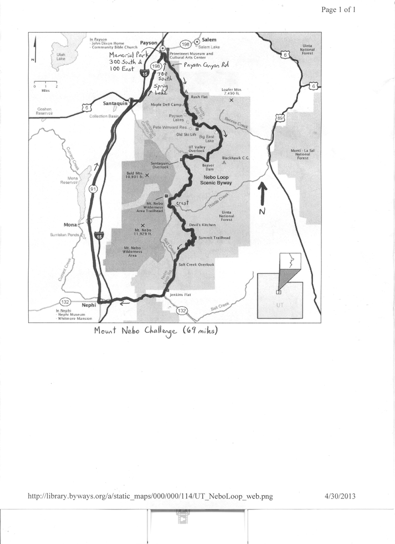
The Mt. Nebo Challenge is a 69.0-mile loop featuring a long, strenuous climb and steep, challenging descent of Mt. Nebo, and long false flats through Juab Valley. The elevation ranges from 4,722 feet in Spring Lake, south of Payson, to 8,917 feet along the Mt. Nebo Loop Scenic Byway. Mt. Nebo, visible from nearly all of central Utah, marks the southern end and highest peak of the Wasatch Range, towering at 11,928 feet. There are several adjacent peaks that are nearly as high. The featured road, Mt. Nebo Loop Scenic Byway, is closed during the winter; always be aware of weather and road conditions before venturing up the mountain.
About half of the Mt. Nebo Challenge is dedicated to the Nebo Loop, which is a National Scenic Byway. The other half, in contrast, consists of a mostly serene trip along long, often open stretches along the west side of the mountain. Mt. Nebo has been visited twice by the modern-day version of the Tour of Utah; in 2009, the mountaintop stage winner was South African Darren Lill, and in 2010, eventual overall Tour winner, disgraced-but-reinstated Levi Leipheimer soloed to victory. The Tour of Utah was scheduled to return to Mt. Nebo in 2013, although not necessarily for a dramatic high-mountains finish.
(www.byways.org).
The Mt. Nebo Challenge is described in the clockwise direction, but can be ridden counterclockwise, as well. The ride starts at Memorial Park in Payson, which is bound by Main Street, 200 East, 200 South, and 300 South. Payson, with a population of 18,294 in 2010, is located 15 miles south of Provo, in southern Utah County, along the I-15 freeway. The city’s claims to fame include the location for most of the filming of Footloose (despite the film’s allegiance to Lehi), and the hometown of singer-songwriter Jewel. The city was originally named Peteetneet, after a Ute chief, but was renamed for James Pace, a mid-19th century homesteader, to facilitate improved pronunciation. Leave the park toward the south, along 100 East. Turn left onto 700 South, followed by a right onto Payson Canyon Road. At 800 South, turn right again to continue on Payson Canyon. The road climbs gradually. At mile 4.3 a cattle guard seems to mark the gateway to the Nebo Loop Scenic Byway, as the road continues. Enter Uinta-Wasatch-Cache National Forest at mile 4.8. The climb gets steeper within one-half mile of entering the forest.
Presuming that you have quickly found your climbing legs, settle into a rhythm that will sustain you for the next 20 miles. The climb eases for short segments, offering brief breaks. Speaking of break, Maple Dell is at mile 5.5 (bathrooms, water). After one mile of steep climbing, the climb eases for about three miles. At mile 9.4, a steep, two-mile climb is followed by a false crest, and then an immediate resumption of steep climbing. The Payson Lakes turnoff is at mile 12.3 – tempting! After taking a moment to refresh, perhaps, continue the ascent. Note that the Nebo Loop is prized for its scenery, particularly the foliage, which is breathtaking at nearly any non-winter time, but especially so during the late summer. The climb finally eases at mile 13.3, but a steep climb follows at mile 14.3.
After a false crest at mile 14.7, there will be a series of steep climbs, crests, and short descents for the next 10 miles. The net result, however, is continued climbing. As the road ascends through the trees, dramatic overlooks begin to appear on either side of the road. At mile 16.3, there is an astonishing dropoff, on the left, into Holman Creek and Beaver Dam Creek Canyons. At mile 17.4, to the right, is a dramatic overlook of Utah Valley, featuring distant Utah Lake. The Santaquin Canyon Overlook is on the right at mile 18.7, followed by Bald Mountain (10,913 feet) Overlook at mile 19.8. The ascent continues with numerous, spectacular vistas, for the next five miles. Around mile 23, you may begin to see snow, certainly on the now-nearby high peaks, even into late July. The Mount Nebo Overlook is at mile 24.9. This is the crest of the climb (nearly 9,000 feet!). A few short climbs break up the forthcoming descent.
The descent of the Nebo Loop begins steeply, then eases. Enter Juab County at mile 27.8. The Devil’s Kitchen Geologic Area is to the right at mile 28.9. The spires and red rock cliffs are similar to those at Bryce Canyon in southern Utah. Note that the “Kitchen” is down slope, and you may have to strain – or perhaps stop for a moment – to see the formation. At mile 30.2, at the Salt Creek Overlook, the descent gets especially steep – control your speed through here. After about 3 miles of sheer plummeting, the gradient finally eases. Leave the U-W-C Forest at mile 37.2; turn right onto State Route 132 at mile 37.9. This marks the end of the Nebo Loop Scenic Byway. From here, it is a 4.4-mile, generally downhill trip through Salt Creek Canyon to the outskirts of Nephi.
Enter Nephi at mile 42.3 with a right turn at the canyon “exit.” There was no street sign when I passed through here, but the turn is easily identified by the gasoline station (Tesoro) and convenience mart located 0.3 miles from here. This would, in fact, be a good place to refresh. After passing under I-15, a street sign indicates that you are on 700 North. Nephi, named after a Mormon prophet, had a population of 5,389 in 2010, and is the principal city in Juab County. Continue along 700 North to Main Street. Turn right here, and head north. Thus begins a long, northerly trek along old U.S. Highway 91, generally parallel to and just west of I-15, through Juab Valley. Sights along the way include the city of Mona – where singer-actor-storyteller Burl Ives was once jailed for crooning a bawdy song – and the Young Living Family Farm, which features fresh lavender, herbs and a distillery.
Enter Santaquin at mile 62.2. The road bends to the right, and then left, putting you on 200 West in town. Santaquin is a growing city, with a population of 9,128 as of 2010. The city is perhaps best known as the final place of residence of actor Gary Coleman. After riding through the heart of town, past some tempting eateries and markets, the road passes under I-15, and then bends left, at mile 63.9, becoming State Route 198. The highway passes through the small community of Spring Lake (population 458 in 2010), and the ride’s lowest elevation. Antonga Black Hawk, who led numerous raids during the Black Hawk War, is buried here. Despite its proximity to the Provo urbanized area, residents rely on wells for water. Enter Payson at mile 66.8; you are now on State Street. Turn right on 300 South and continue to Memorial Park to conclude the ride.
The Mt. Nebo Challenge will be part of an upcoming volume of Utah rides.
For more rides, see Road Biking Utah (Falcon Guides), written by avid cyclist Wayne Cottrell. Road Biking Utah features descriptions of 40 road bike rides in Utah. The ride lengths range from 14 to 106 miles, and the book’s coverage is statewide: from Wendover to Vernal, and from Bear Lake to St. George to Bluff. Each ride description features information about the suggested start-finish location, length, mileposts, terrain, traffic conditions and, most importantly, sights. The text is rich in detail about each route, including history, folklore, flora, fauna and, of course, scenery.
Wayne Cottrell is a former Utah resident who conducted extensive research while living here – and even after moving – to develop the content for the book.
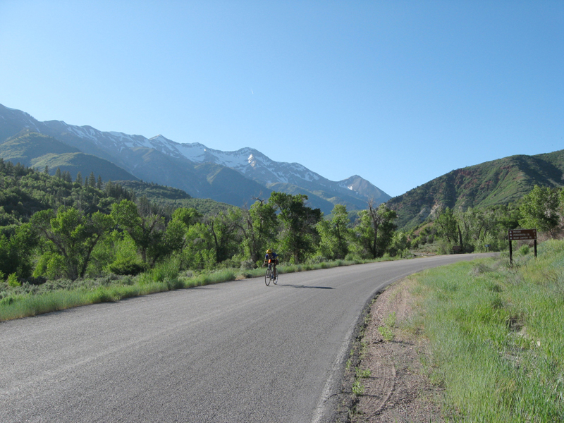
Mt. Nebo in the background.
Photo: Wayne Cottrell
Thanks for the write up! I finally did it yesterday for the first time and it was one of the better rides I think I’ve ever done.
One note for consideration- When I repeat this ride, I’ll consider steps to mitigate the hazards of SR 132 in Nephi canyon.
I started riding at 8am in payson. Traffic on the loop road was light and drivers were very considerate.
Coming off of the Loop road around noon, I was surprised by a few sections of 132 that drop to zero shoulder-literally whiteline on gravel. Combined with some motorists (including double-trailer gravel trucks) that could not find it in their hearts to slow, honk, or move into the empty oncoming lane to pass, I found this to be a couple of the sketchiest miles I’ve ever ridden.
Ride north from Nephi was chill.
Possible mitigation strategies:
1. Start early in Nephi and ride counterclockwise, hopefully hitting minimum traffic on 132.
2. Start early, somewhere around the southern forest boundary- maybe ponderosa C.G.?- and ride clockwise. This would probably have the least traffic exposure on 132, riding downhill in the early AM.
3. Utilize a car shuttle to eliminate travel on 132.
Thanks again for the great write up.