 the Monte Cristo Range in northeastern Utah.)
By Wayne Cottrell
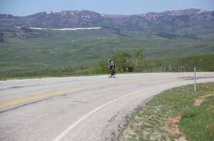
“Monte Cristo” conjures up images of an island in the Mediterranean Sea, a sandwich, and a fictional character created by Alexandre Dumas père. In the context of Cycling Utah, however, the Monte Cristo Classic is a 97.8-mile, out-and-back ride up, over and back (and up & over) the Monte Cristo Range in northeastern Utah. The route is very simple in that 99% of it is on State Highway 39 (SR 39), between Huntsville and Woodruff. The Monte Cristo Range reaches a peak of 9,081 feet atop Mt. McKinnon, making it one of Utah’s “shorter” ranges. The low point of the ride is at the start-finish point in Huntsville, at 4,939 feet. The peak (9,030 feet) is along SR 39 near Dairy Ridge Road, near Mt. McKinnon, in the Monte Cristo Range. The elevation at the turnaround in Woodruff is 6,347 feet. The elevation difference between the high and low points, therefore, is 4,142 feet, making this a ride with a significant amount of high-altitude climbing. Please note that SR 39 between Huntsville and Woodruff is closed during the winter, so be sure to check road conditions during the early spring and late autumn months. Also, be prepared for cooler temperatures at the higher elevations, even during the warm summer months.
Start the ride at Huntsville Park, in Huntsville, located at the corner of 7400 East and 200 South. Huntsville is a small community of about 650 people, nestled against the east side of Pineview Reservoir, in the Ogden River Valley. The ride is very accessible, with Huntsville being no more than 15 miles from central Ogden. From the park, head north on 7400 East, and turn right onto Main Street. Cross the highway (SR 166-SR 39 junction) at mile 0.5 and keep straight. You are now on SR 39, heading eastward and, in general, up. The climbing is not steep, but is long, gradual, and steady. There are numerous campgrounds along the way. Causey Road, leading to Causey Reservoir, is at mile 8.9; you may see motor vehicles towing boats and making turns here. Red Rock Ranch, with outfitters, a gift shop and restaurant, is at the corner. The highway quiets down significantly beyond this point, carrying no more than 400 vehicles per day. Also, note that the highway’s prevailing orientation is actually north-south for a long stretch, before once again turning and heading east.
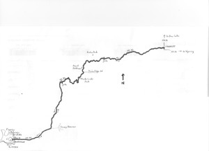 The western portion of the ride’s route on SR 39, as far as the high peaks of Monte Cristo, is part of the Ogden River Scenic Byway, The scenery along SR 39 can be spectacular, particularly during the autumn, when the fall colors brighten up the forestation. As the highway climbs, the trees become decidedly alpine, dominated by birch, evergreens and pine. Also, moose occasionally wander near and across the highway. Distant mountain peaks can be spotted from various vista points along the way. Although SR 39 is indeed closed during the winter, a spring or autumn ride when the roadsides have been “dusted” with snow can reveal some postcard winter scenes. About halfway to Woodruff, the highway ascends into the highest peaks of the Monte Cristo Range, straddling the line between Weber and Cache Counties. The road twists and turns as it makes it way past Little Monte, Monte Cristo Peak (on the right) and, eventually, Mt. McKinnon (on the left). This is the high point of the ride.
Beyond the crest, SR 39 makes a long, gradual descent into Rich County. This county is one of Utah’s most sparsely populated, with just over 2,260 persons as of the latest count. Given that the highway is closed during the winter, Rich County is also one of Utah’s most remote, with access only from the north and south for nearly half of the year. Woodruff, one of Rich County’s few settlements, is the turnaround point of the ride (at the SR 16 junction). The town’s population was just 180 as of this writing. Nearly three times this many folks once lived here, though, and part of the town’s legacy is evidenced in the Woodruff Stake House, a national historic site. The structure is located at 50 South Main Street, just one-half block to the south of the ride’s turnaround point. You are encouraged to take the short detour to view this historical building.
The return ride is notably more forgiving than the outbound ride. Since the starting elevation is 6,347 feet in Woodruff, the elevation gain to Mt. McKinnon is less than it was when heading outbound. Once beyond the crest, the descent – all the way back to Huntsville – is fast and enjoyable. Follow SR 39 westward; after passing the high peaks, the highway will head southward for a long stretch, before turning west again. At the junction with SR 166, continue heading west, straight into Hunstville, via Main Street. Turn left on 7400 East and head south to Huntsville Park, to conclude the ride.
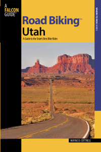 For more rides, see Road Biking Utah (Falcon Guides), written by avid cyclist Wayne Cottrell. Road Biking Utah features descriptions of 40 road bike rides in Utah. The ride lengths range from 14 to 106 miles, and the book’s coverage is statewide: from Wendover to Vernal, and from Bear Lake to St. George to Bluff. Each ride description features information about the suggested start-finish location, length, mileposts, terrain, traffic conditions and, most importantly, sights. The text is rich in detail about each route, including history, folklore, flora, fauna and, of course, scenery.
Wayne Cottrell is a former Utah resident who conducted extensive research while living here – and even after moving – to develop the content for the book.