Southern Utah is treated, perhaps, to the first signs of spring in the State. With the exception of extreme southwestern Utah, southeastern Utah begins to see climbing temperatures as early as late March. For example, in April, it is usually warmer in Bluff than in Cedar City. Thus, a great springtime escape for northern Utahns would be to head for the moderate climes of southeastern Utah. This ride travels through some of southeastern Utah’s amazing scenery, enabling the cyclist to see some of the State’s most well-known sights and images, while getting a fantastic workout.
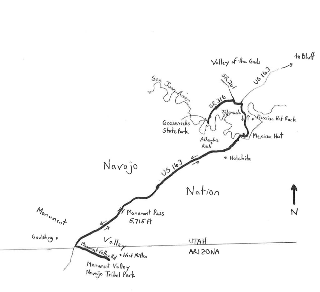
The Meanders to Monuments Classic is a 64.9-mile out-and-back ride having a net elevation difference of 1,605 feet. There are no steep climbs or descents, but there are several long, gradual upgrades and downgrades. The ride starts at out-of-the-way Goosenecks State Park, located along the San Juan River, north of the Navajo Nation boundary, just beyond the far eastern boundary of Glen Canyon National Recreation Area. If names such as Moki Dugway, Valley of the Gods, Mexican Hat Rock, and The Tabernacle ring a bell, thing you know where this is. If not, then the best way to get here – and the out-of-the-way location adds to the mystique – is to head southeast from the Salt Lake City area to Moab, via I-15, U.S. Route 6, I-70, and U.S. Route 191. Continue heading south from Moab on US 191, through Monticello, Blanding, and Bluff. Beyond Bluff, continue heading westward on U.S. 163 rather than on U.S. 191, which heads south into Arizona. Turn right on State Route (SR) 261, and then left onto SR 163. Drive 3.5 miles to the end of the highway, at Goosenecks State Park. This is where the ride begins.
Goosenecks State Park overlooks the deep meanders of the San Juan River. The depth of the canyon here is about 1,000 feet. The dramatic incisions made by the river, carved over thousands of years, create a stunning visual. From your left to your right, panning the near horizon, the river “goosenecks” through ten miles over a straight-line distance of about three. I arrived here at dusk once, running late, such that the darkness prevented me from seeing the bottom of the canyon. I was the only soul around, and I could hear the faint sounds of the chasm, only imagining its depth! There are vault toilets at the park, but no water, so be sure to bring your own. From a starting elevation of 4,980 feet, SR 316 descends gradually to the junction with SR 261 (which is part of the Trail of the Ancients Scenic Byway). Turn right here, at mile 3.5, and ride to US 163 (mile 4.4). Turn right and head south. Along the way, well off to your right, you may be able to spot the top of The Tabernacle, which is a nearly island land mass that has been carved out by the twisting San Juan River. To your left, along SR 163, is Mexican Hat Rock, a formation that resembles a balancing sombrero. The formation is so famous that the next town is named Mexican Hat! This a small but extremely scenic settlement, established adjacent the river. There is a lodge and a trading post here. At the edge of town, SR 163 makes a sharp, left-hand bend to cross the San Juan River. This is the low elevation of the ride (4,110 feet).
From the river, SR 163 climbs gradually. The only real negative aspect of this segment of the ride is the highway’s narrow shoulder. Yet, the highway is famous, even in cycling lore, having been ridden as part of the Race Across America route, and as a regular segment in the Race Across the West. Nonetheless, ride cautiously, especially on curves. The turnoff to the town of Halchita is at mile 9.55. This segment of SR 163 is essentially entirely within the Navajo Nation, as reflected in that fact that some 98% of Halchita’s several-hundred residents are Native-American. The traffic volume on SR 163 increases southwest of Halchita (up to 2,100 vehicles per day). The landscape out here is marked by a vivid red color, generated by iron oxides exposed within the mostly siltstone floor of the valley. There are also some darker, blue-gray colors generated by manganese oxide. The numerous fissures and canyons have been carved by washes and springs over the years. Millions of years ago, this area featured volcanic activity. With the extinction of the volcanoes came the subsidence of the land, exposing volcanic “plugs” that have remained resistant to erosion. Hence, the peaks, spires and spikes that you see out here are the remnants of ancient volcanoes. The high elevation of the ride at Monument Pass (5,715 feet), crossed at mile 19.2, marks the gateway to Monument Valley. Here, the numerous sentinels of the valley come into clear view, including the iconic West and East Mittens. It is a gradual descent across the valley.
Monument Valley is etched into many a person’s vision of the old American West, in part because of filmmaker John Ford’s repeated use of the region for his Westerns. These included such classics as “Stagecoach” and “The Searchers,” among others. As the monuments get close enough to touch, turn left onto Monument Valley Road (elevation 5,202 feet at mile 24.8), and head southeast. The road enters Arizona, climbing gradually to the end of the road, at the Monument Valley Navajo Tribal Park’s visitor center (elevation 5,607 feet). There may be a fee ($20 for motor vehicles; unknown for bicycles). This is the turnaround point of the ride (mile 32.45). Be sure to replenish your water here. If you have time, though, take a break and visit the center. Or, better yet, take a guided tour!
The return ride features a gradual descent to SR 163 (2.1% grade), a long, gradual climb to Monument Pass (1.7% grade), an even longer, gradual descent to Mexican Hat (2.0% grade), and then a gradual climb to Goosenecks State Park (2.0% grade). The scenic views and icons along this ride, now seen from a different perspective, keep things interesting and memorable for the entire route. As you return to Goosenecks State Park, be sure to slow down at the end of the road, as there is no barrier between you and the incisions!
Start/finish coordinates: 37.174503oN 109.927267oW
For more rides, see Road Biking Utah (Falcon Guides), written by avid cyclist Wayne Cottrell. Road Biking Utah features descriptions of 40 road bike rides in Utah. The ride lengths range from 14 to 106 miles, and the book’s coverage is statewide: from Wendover to Vernal, and from Bear Lake to St. George to Bluff. Each ride description features information about the suggested start-finish location, length, mileposts, terrain, traffic conditions and, most importantly, sights. The text is rich in detail about each route, including history, folklore, flora, fauna and, of course, scenery.
Wayne Cottrell is a former Utah resident who conducted extensive research while living here – and even after moving – to develop the content for the book.