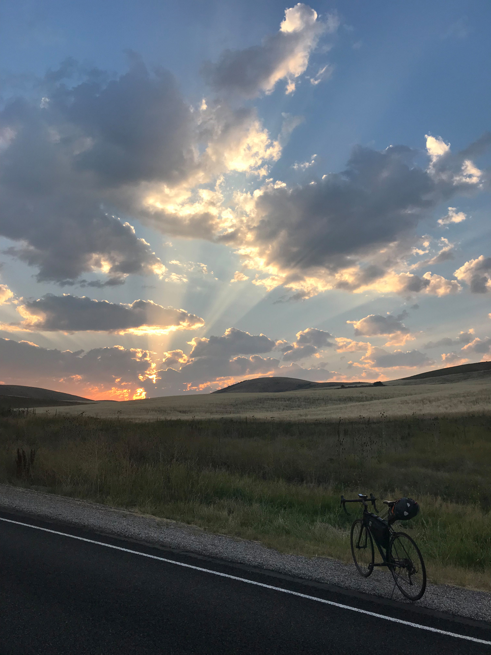
By David Collins — Idaho is blessed with iconic geography and interesting diversions. Although these rides include stunning scenery, they often feature hidden gems and forgotten highways and byways – a cyclist’s dream – filled with unforgettable imagery, points of historical interest and quirky pit-stops.
Extended shoulder seasons are usually the best time to ride most of these routes but depending on your skills, equipment, local conditions and road closures, you might be able to ride throughout much of the year. Be weather aware, riding conditions can swiftly change.
Excursions and explorations are part of the fun of unsupported bicycle touring at your own pace. Mileage estimates are approximate and may vary depending on your tracking system and whims of the ride. Be sure to tell someone your plans and allow them to track your location using a smartphone or other device.
Solo or unsupported distance cycling often presents potentially dangerous situations related to terrain, weather, equipment, traffic, navigation and mental awareness. Even experienced cyclists must plan carefully and use wise judgment to successfully mitigate inherent risks of the sport or terminate a ride before it turns injurious or deadly. If you are new to the sport or have never ridden a bicycle 100 miles in a single day, learn the ropes with a seasoned buddy or local riding club before giving one of these routes a go.
Make sure to check maps, plan your route and check local road conditions before you go. As with any ride, be aware of your surroundings and of roadway traffic.
Time to fill water bottles, stuff gear bags, click in and start pedaling central and southeastern Idaho’s great century rides.
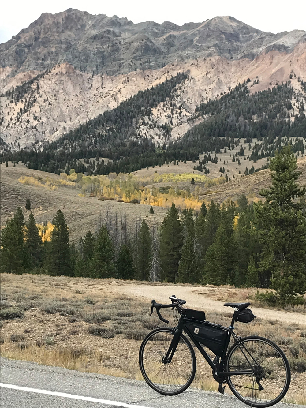
Sage, Sun Valley & Sawtooths
Route: Shoshone, Bellevue, Hailey, Ketchum/Sun Valley, Stanley (one way). North on Idaho 75. 116 miles.
Terrain: Farms and ranches, sage and lava basalt, charming and sometimes chichi townships, a high mountain pass and breathtaking alpine skylines.
What to See: Flats from Shoshone until a few miles south of Bellevue (where long mild rollers lazily rise and fall) passing through fertile farm and ranch lands, miles of sage and lava field basalt and nearby notable caves. Traffic builds just as you approach Bellevue and doesn’t disappear until a mile or two past Ketchum. The road is still flat through Belleview, Hailey and Ketchum/Sun Valley, but fabulous hills and mountains jump right out of the landscape (not hard to imagine how these mountains got their Sawtooths name). Be sure to pit stop in a town or two and keep your eyes out for movie stars and celebrities flying into Hailey on their private jets and musing around town with the locals. A quick mile or two detour from Ketchum to the famed Sun Valley Lodge is a must too. The resort area is cycling friendly and laced with paved bike trails. The road begins to climb at about the 75-mile mark and crests a few miles later (after a 6 – 7% grade climb) on the top of Galena Summit at 8,700 feet. Enjoy riding down the other side into a valley lined by stunning ragged and high alpine mountains (think Idaho Alps). Pick-up the headwaters of The River of No Return (Salmon River) and finish out the day by rolling mostly flat through the valley to Stanley.
Selfies and Photo Ops: From the beginning to Stanley: Mammoth Cave signs; Shoshone Ice Cave sign; Nobel Prize winning author Ernest Hemmingway’s grave (in the Ketchum Cemetery on Main Street); Sun Valley Lodge and pond; mountain pass views, ascending & descending; Galena Lodge; Headwater of the River of No Return sign; Sawtooth Fish Hatchery; Sawtooth Mountains throughout (beginning from about Hailey until Stanley), river crossings and bankside views (Wood, Salmon)
Wildlife: Mule deer, elk, moose, mountain goats, cougars, bobcat; lynx, bears (black and grizzly), snakes, beaver, fisher, marten & mink, porcupines, pronghorn, fox, wolverines, birds of prey and prize trout (brook, bull, lake, rainbow, steelhead, cutthroat) and salmon (chinook, sockeye/kokanee).
Best Post-Ride Eats: Mountain Village Restaurant in Stanley. After slipping past the friendly stuffed black bear trophy, find a seat in back of the log cabin lodge style restaurant, cash in your free drink tokens (given at check-in at the Mountain Village Lodge) and take a few sips while pondering between the House Smoked Baby Back Ribs and the Sausage Plate (featuring andouille, black & blue and garlic knackwurst from Jackson Hole Wyoming’s Bovine and Swine). A small side of sirloin chili made with dark beer and topped with cheddar cheese wouldn’t hurt either, since this is a recovery meal and proteins are just what the doctor ordered. Another drink or two and you’ll be set for some serious time in the sack.
Still Have Legs, lungs and Sunlight? Turn west at the sign for Redfish Lake (near Stanley) and drop a line in the Sawtooths’ largest alpine lake – home to prize sockeye/kokanee salmon. Even if you don’t have a rod & reel, the short detour is worth the photo ops with the lake and alpine mountain backdrops (about a 5-to-6 mile total detour depending on where you turn back).
Notes: Although several villages dot the way, cell coverage is weak or not available for long stretches of the ride. This route features prime three-season riding (winter road cycling conditions are usually dangerous and often unpredictable). Also, you’ll be rolling through the Wood River Valley, be sure to stop periodically and breathe deeply though your nose. It may be the best outdoor aroma in America, especially after one of the common summer showers.
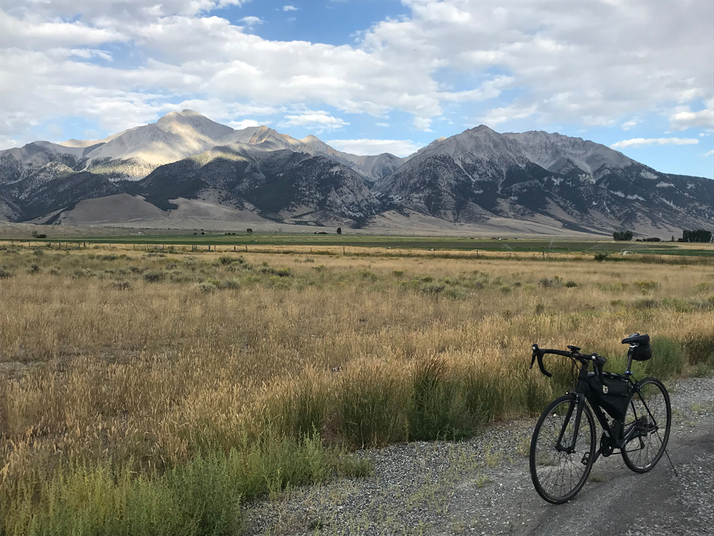
Mackay to Salmon
Route: Mackay (pronounced MACK-ee), Challis, Ellis, Salmon (one way). North on Hwy 93. 112 Miles.
Terrain: Rolling roads through rural valleys surrounded by dramatic foothills and looming peaks, turns hilly – cresting over Willow Creek Summit just over 7,000 ft, riverside riding from Challis through the final destination.
What to See: Ghost towns Cliff City and White Knob west of Mackay. The ghost town sign on Main Street in Mackay is about all that’s left standing though, so if you don’t have time, don’t pursue the actual sites, or if you do, don’t be disappointed since rubble may be all you find after hiking a mile or two; miles of riding through the Lost River Mountains including past several 12,000+ ft. mountains starting with Mount Borah through the Mackay Dam (Borah, Leatherman, Church, Donaldson, Breitenbach, Lost River and Bad River Peak, an honorable mention rising just 46 ft short of being a twelver too); Grandview Canyon featuring rugged and jagged cliffs side-to-side descending into Challis; mostly flat riverside riding from Challis on, often hugging the banks of the River of No Return (discovered by Lewis and Clark – until 1950, boats could not ascend the main canyon, so the Salmon got the nickname “River of No Return”, large tracts of untamed wilderness still blanket the Salmon River Mountains); Sacajawea Interpretive, Cultural and Educational Center near her childhood home – today’s Salmon.
Selfies and Photo Ops: Periodic Peaks to Craters Scenic Byway signs; Ghost Towns of Mackay sign (see What to See above); long lineup of twelvers in the Lost River Mountain Range, Mile High Outfitters laser cut sign on the northern edge of Challis; too many Salmon River photo ops to mention here, deer warning and “Say no to drugs and alcohol, let’s go fishing” billboards just north of Challis; Ellis Post Office storefront; Idaho Hermits sign about 11 miles before Salmon; 45th Parallel sign; Statue of Sacajawea at the Sacajawea Interpretive, Cultural and Education Center (seek an especially good angle showing the giant Bitterroot Mountains in the back ground – her childhood playgrounds); Welcome to Salmon, Home of Sacajawea sign on south side of town.
Wildlife: Mule deer, elk, moose, mountain goats, cougars, bobcat; lynx, bears (black and grizzly), snakes, beaver, fisher, marten & mink, porcupines, pronghorn, fox, wolverines, birds of prey and prize trout (brook, bull, lake, rainbow, steelhead, cutthroat) and salmon (chinook, sockeye/kokanee).
Best Post-Ride Eats: Bertram’s Brewery on Andrews Street in Salmon. Ice cold house-brewed beer is the calling card here but don’t let that fool you – this casual brewpub also boasts delicious steaks and seafood. Try the Blackened Rainbow Trout served with mango salsa, paired with house-brewed Hazelnut Ale. If you have room, order the Fish Tacos too, not what you may be expecting though, they’re mini corn taco bowls cradling battered cod, cilantro, lime, guacamole, mangos and some kind of magic potion. Who would’ve guessed a joint in Salmon would build out foodie tacos? A tasty end to a memorable ride.
Still Have Legs, lungs and Sunlight? To ride the other side of the Lost River Range, head south from Mackay to Arco, and up the Sacajawea Historic Byway through Leodore to Salmon. It’s a whale of a ride and may require an overnight stay along the way (178 miles instead of the more direct route described above). Traffic flow is non-existent, and the unpopulated miles of smiles will thrill you. If you go this way, be sure to take the short gravel road detour to well preserved giant kilns from 150 years ago (can’t miss the signs).
Notes: Like many routes through central Idaho, cell coverage is unreliable and/or unavailable for many miles of this ride. Careful planning will help mitigate your chance of related problems. Also, like the Sage, Sun Valley & Sawtooths ride, this route should be considered for three seasons only, winter attempts may turn dangerous and/or impassable. If you choose the Leodore route (see Still Have Legs), be prepared with extra water, nutrition, and camp gear if you turn it into a two-day ride, since periodic fuel stops are rare.
Over the Border
Route: Preston, Thatcher, Grace, Soda Springs, Freedom WY, Etna WY, Alpine WY (one way). North on Idaho 34, north on Non-County Road, east on Creamery Road, north on 89 to Alpine. 122 miles.
Terrain: Aggressive rolling farmlands, Caribou –Targhee National Forest, a handful of agriculture & mining-centric towns and plenty of climbing.
What to See: Pioneer Historic Byway landmarks; a few miles north of Preston, a picturesque bridge over a waterway which connects a small pond on the west side of the road to the larger Foster Reservoir on the east side; fertile farm and ranchlands through Soda Springs; Lewis and Clark Trail crossings; Oregon Trail crossings; Blackfoot River Reservoir (home to several bird species including oft seen soaring bald eagles and white pelicans; skirt hems of Grays Lake National Wildlife Refuge; Caribou-Targhee National Forest; Freedom Firearms; northern armlet of the Star Valley Scenic Byway including a brief roll near the southernmost tip of the Palisades Reservoir; at the finish line, the Snake River as it flows into the Palisades Reservoir.
Selfies and Photo Ops: Napoleon Dynamite storefronts (the cult comedy was filmed in Preston), rising roller horizon emerging from the Foster Reservoir water crossing; the vast open patchwork of farmlands unfurled around Thatcher and Grace; various roadside farm stands; Blackfoot River Reservoir resort and campground at water’s edge; Soda Springs historical marker sign (near South 3rd Street West on the west side of Soda Springs) explaining the acid taste and “effervescing” gasses of the water; Oregon Trail Memorial with picturesque cliff back drop (look for the signs for the short detour to the memorial in Soda Springs) Freedom Firearms sign (Freedom WY), manufacturing home of famous single-action revolvers; Snake River in Alpine.
Wildlife: Upland gamebirds, birds of prey, pelicans, turkeys, fox, coyotes, beaver, deer, elk, rattlesnakes, gamefish, mountain lions, bears, martens and badgers.
Best Post-Ride Eats: Bull Moose Saloon in Alpine. As part of the on-site Bull Moose Lodge, Saloon, Restaurant and Liquor Store joints, the restaurant serves up reasonably priced mountain town fare. It won’t be the finest meal of your life, but the food is good and the atmosphere is relaxing after a long ride. Start off by drenching a basket of fries in ketchup and a half dozen chicken taquitos while sipping a drink or two, the saloon and liquor store sister businesses make for lots of hard options. Entrée up with a rib-eye steak and all the fixings or the prime rib (only served on weekends). Warm pecan pie and ice cream for dessert and you’ll be ready for bed – no problem there, just cross the parking lot and stop, drop and sleep in your log cabin-ish room at the lodge.
Still Have Legs, lungs and Sunlight? Head east on Hwy 26 to Hoback Junction (24 miles). It’s a winding road that hugs the Snake River through a famously picturesque canyon. If you extend your ride to include this leg, chances are, you’ll be riding near dusk, which is a great time to take in the beauty of the greater Jackson Hole region. Fish will be jumping and big mammals will be strolling nearby. There’s a good shoulder to ride most of the way, but be sure to have proper lights on your bike, especially as daylight fades. And of course, you’ll note how close you are to Jackson Hole as you study the map. Take another day or three and ride through town on your way to cycling two national parks; Grand Teton and Yellowstone.
Notes: Don’t be fooled by the rightfully so romantic description; the ride features 5,000+ feet of elevation gain which can pack a surprising punch if you’re not expecting it. Be prepared to make frequent stops for pictures, but keep your eye on the clock, otherwise you may run out of daylight before you’re done and night riding in the area is not advisable.
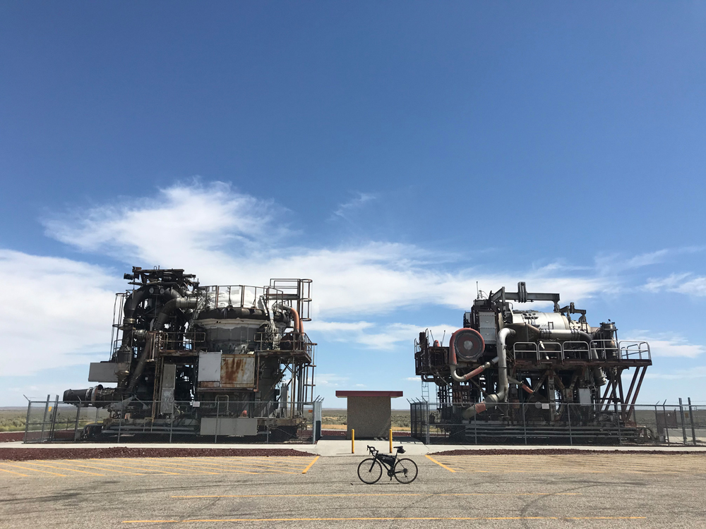
Idaho Falls to Arco (with Craters of the Moon loop)
Route: Idaho Falls, Butte City, Arco, Craters of the Moon National Monument and Preserve, back to Arco. West on Hwy 20 with a little back tracking for a second visit to Arco after riding around in the Craters of the Moon National Monument and Preserve. 116 miles.
Terrain: Flats, flats, flats, with a few miles of risers between Arco and Craters of the Moon.
What to See: 14 Mile Cave (14 miles west of Idaho Falls) – takes a little while to sneak a peek, but it’s worth it if you’re into caves; Three Great Buttes dominating the southern skyline upon leaving Idaho Falls; EBR-I, the world’s first nuclear power plant and museum is a quick detour worth checking out; two gigantic structures (across the parking lot from EBR-1) are test stands containing atomic jet engines – remnants of a joint U.S. Air Force and Atomic Energy Commission program to build a nuclear-powered aircraft in the early 1950’s (President Kennedy cancelled the program after a decade of work); kitschy Butte City buildings; cliff face in Arco proudly displaying “class of ___” giant graffiti marks going back decades; various Arco murals and signage bragging “Arco, Idaho – First City in the World to be lit by Atomic Power”; Craters of the Moon National Monument and Preserve – worth the entrance fee which includes access to a cycling-friendly loop that winds through cinder cones, lava tubes, volcanic bombs, tree molds and spatter cones all in a surreal setting that sometimes really does seem like a cousin to lunar surface scenes depicted in NASA pictures.
Selfies and Photo Ops: Downtown historic buildings including the 1915 terra cotta Renaissance Revival Shane Building on Shoup Avenue; the 1926 Italian Renaissance Bonneville Hotel on Constitution Way and the 1909 Romanesque Revival motif I.O.O.F Building on Park Avenue; Snake River waterfalls in downtown Idaho Falls; Philo T. Farnsworth related signs (see Still Have Legs); opening miles of flat desert horizon; Great Butte southern backdrop; EBR-1 and Arco signs (see What to See); Pickle’s Place in Arco; too many spots to mention in the Craters of the Moon National Monument and Preserve – the loop in the preserve is a nature photographer’s playground; rolling hills horizon between Arco and Craters; storefronts and buildings in Butte City and Arco.
Wildlife: Rattlesnakes (locals tell sobering stories, legends and likely whoppers about rattlesnake infestations in the Great Buttes area – yikes!), river otters, mule deer, elk, fisher, marten & mink, porcupines, pronghorn, fox and birds of prey.
Best Post-Ride Eats: Pickle’s Place in Arco. Think delicious homemade fare served in a family owned and operated restaurant. The 4-piece broasted chicken dinner is outstanding. It’s some kind of heavenly fried chicken-ish thing they create in the kitchen and serve up crisp and hot. Be sure to add a couple of whole pickles to the order and wash it all down with huckleberry lemonade. Finish in style with a double order of pie a la mode. If you ride this route in reverse, order up a couple of double cheeseburgers at the Blue Wave Bar and Grill on Rollandet in Idaho Falls. Best burgers in Idaho – bar none.
Still Have Legs, lungs and Sunlight? Add another 15 miles by starting in Rigby (instead of Idaho Falls) and heading south on HWY 20. Why Rigby? Home of the Farnsworth TV and Pioneer Museum, Rigby boasts they are the childhood home of Philo T. Farnsworth, who invented television. You may not have time to peruse the tiny museum, but it’s worth a selfie or two featuring one of the related signs in and around Rigby.
Notes: Pay close attention to restricted access signs west of Idaho Falls. They mark miles of Idaho National Laboratory (INL) boundaries. INL is a Department of Energy base historically focused on nuclear energy, national security and environmental science. They take their “stay out” signs seriously and are not friendly to those who don’t.
American Falls to Pocatello (the Arbon Valley Loop)
Route: American Falls, Rockland, Holbrook, Arbon Valley, Mink Canyon, Pocatello. South on Idaho State Hwy 37 to the edge of Holbrook, east on W 2000 S, north on 17200 W (turnoff to Arbon Valley), north on Arbon Valley Road, east on Mink Creek Road (turns into Bannock Hwy) to Pocatello. 117 miles.
Terrain: Immediate aggressive rollers slowly smoothing into Rockland, slices through high distant (or sometimes close) mountains, lush fertile farmland and livestock country, deceitfully testy mild and medium climbs and descents capped off with passage through a higher mountain pass.
What to See: Modern windmills strewn throughout the opening miles of the first foothills; main Rockland drag – just a few hundred yards long; two-mile detour through tiny Holbrook; Curlew National Grasslands (route passes through the grasslands twice), giant pivot irrigation systems covering acres of farm and ranchland; flat lands of Arbon Valley punctuated by periodic short arroyo rollercoaster bumps; Mink Canyon cabins and homesteads (from humble to palatial); old town Pocatello’s historic buildings; Montana coined itself ‘Big Sky Country’ but the big sky phenomenon leaked southward to this route, look up and take in the expansive skies amidst your likely struggles with the winds (see Notes).
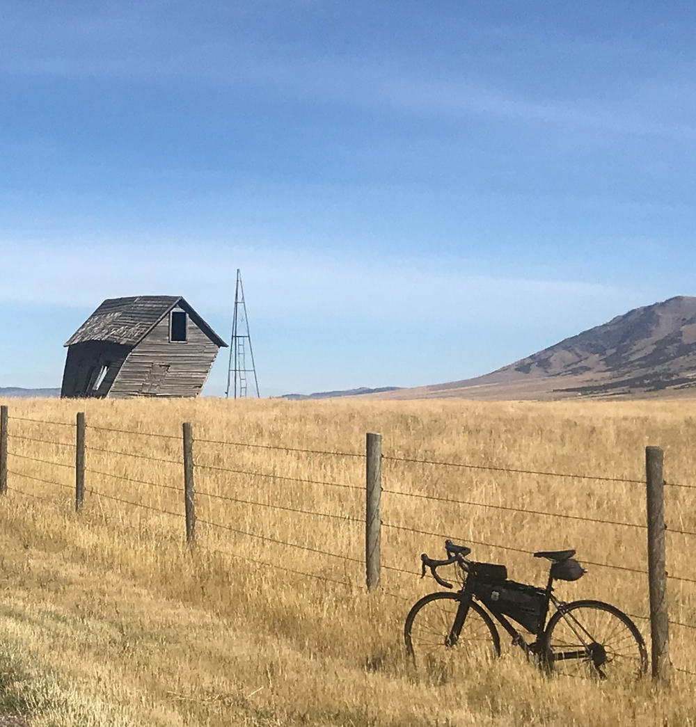
Selfies and Photo Ops: Windfarm backdrops; Rockland Post Office façade; boarded up big blue house just north of Holbrook (reminds me of the popular turn of the century kids TV show Bear in the Big Blue House); Welcome to Holbrook sign on the east side of the village; a ghost town like outbuilding that’s barely standing in a drunken lean (on the east side of the road before the Mink Creek turn – can’t miss it); cross in front of the Arbon Valley Bible Church; landscape near the cresting Mink Creek pass; original art deco-ish Chief Theatre sign from 1938 in old Pocatello; the Idaho State University Greek pillars on Red Hill (a Pocatello landmark and I.S.U. icon).
Wildlife: Mule deer, elk, pronghorn, snakes, upland gamebirds, birds of prey, mountain lions, bears, martens, badgers, skunks and other little varmints.
Best Post-Ride Eats: Elmer’s on 5th Avenue. A laid-back joint serving home cooking in generous portions awaits your après cycling meal. Salad for a post-ride starter? Usually not in my plan, but the Dungeness Crab BLT salad is an exception and kicks-off supper with a lilt. For the entrée, tuck into the 12 oz. slab of prime rib (only available after 4:00 pm). Since breakfast items are served all day, follow the protein-laden meal with lingonberry crepes. They are sweet, tart and dusted with confectioners sugar, the perfect finisher after a long day of pedaling all the way around the Arbon Valley Loop.
Still Have Legs, lungs and Sunlight? Head north from Pocatello on Hwy 91 through Chubbuck and into Fort Hall, a township in the Native American reservation of the Shoshone-Bannock Tribes. While you’re there, get one of those savory bison burgers at the gas station by the casino (24 miles there and back).
Notes: Wind! Entering a windfarm right out of the gate hints this may be a challenging day in the saddle. Since it’s an abbreviated loop that passes through and around different canyons, hills and mountains, it’s not likely you’ll enjoy a prevailing tail wind on any given day. Thankfully, continuous headwinds are not likely either. Be prepared for winds from every side. Also, ride with extra fuel and water since merchant stops are few and cell coverage is spotty or nonexistent for much of the route.
Some of these roads are terrifying. 75 is the main RV route. Outside of the towns traffic is going 65mph and there isn’t always a good shoulder.
Likewise, 20 across Idaho National Labs the traffic goes 80+mph on a two lane highway (and bring your geiger counter to check out your RADs).