By Wayne Cottrell
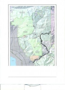
The Alpine Loop Challenge is a mountainous 45.3-mile, out-and-back ride through breathtaking scenery in the Uinta National Forest. The route covers portions of the Alpine Loop Scenic Byway—which is not really a loop—and the Provo Canyon Scenic Byway, starting and ending in Orem. The course features a variety of road types, including a bicycle path, the shoulder of a popular canyon highway, mountainous two-lane roads, and a narrow, twisting mountain road. The entire route can be completed only between late May and late October, when the Alpine Loop Scenic Byway is open. Elevations vary from 4,828 feet near the starting point in Orem to 7,980 feet at the junction with Cascade Springs Drive high in the Wasatch Mountains.
Start at the parking lot adjacent Provo Canyon Parkway, north of 800 North in Orem. The lot is hidden behind a convenience mart. Continue past the mart, into the back parking lot. This is the trailhead for the Provo Canyon Parkway (bike path). Although there are various places to start the Alpine Loop, Road Biking Utah’s version starts and finishes in the city of Orem (i.e., an out-and-back route). Orem, self-proclaimed “Family City USA,” was named in honor of Walter C. Orem, president of the Salt Lake and Utah Electric Interurban Railroad. The city had an estimated population of 93,250 in 2008, making it Utah’s sixth-largest city. The city’s most famous residents are the members of the Osmond family. Computer software giants Wordperfect, Novell, and Caldera all got their start in Orem.

The Alpine Loop Challenge starts at the mouth of Provo Canyon, where the city limits of Provo and Orem seem to duel for the limited space. The steep mountains that line the canyon, part of the Wasatch Range, consist entirely of Paleozoic rocks, including lime, sandstone, and shale. In some places the wedges of rock are 25,000 feet thick. US 189—the Provo Canyon Scenic Byway—snakes up the canyon. There are several parks and trailheads along the highway; its proximity to the heavily populated Utah Valley makes the canyon a busy place. To separate themselves from motor vehicles, cyclists and runners are treated to a bicycle path that parallels US 189 for some distance. Nonetheless, SHARE THE ROAD signs are posted along US 189 to remind drivers of the presence of bicycles on the shoulders.
Enter Uinta National Forest just beyond the mouth of the canyon. The Provo River runs parallel to the highway and parallel path. The river originates at Washington Lake, high in the Uinta Mountains to the northeast. The river flows toward the southwest, eventually draining into Utah Lake. The path crosses under US 189 at mile 3.1, just prior to entering Nunn’s Park. To the right is Bridal Veil Falls, a 607-foot waterfall spectacular that descends in two stages (“double cataract”) from the towering cliffs above. During the winter, the waterfall freezes, becoming a magnet for hardy ice climbers. Continue past the falls to Vivian Park, at mile 5.6. The bike path ends here; turn left onto South Fork Road to access the parallel US 189. There is a railroad crossing just after the turn. Railroad? Yes—the Heber Valley Railroad (“Heber Creeper”) terminates here. Turn right onto US 189 and head north. Stay to the right side of the shoulder to avoid the highway’s rumble strips.
Enter a short tunnel at mile 6.5. The shoulder continues through the tunnel. Cautiously prepare for a left turn onto SR 92 (to SUNDANCE) after exiting the short tunnel. Turn left at mile 6.9 to begin climbing the Alpine Loop. The Sundance Hillclimb, a major bike race for the area’s road cyclists, starts at this junction every year. Also, the Queen Stage of the annual Tour of Utah snakes up this climb on its journey through the Wasatch Front’s mountains. The canyon’s walls are lush; a creek rushes on the left. The climb gets noticeably steeper at mile 7.8. Sundance Resort is on the left at mile 9.2. The road narrows after passing the resort, as the steep climb continues. There are a few switchbacks. A pedestrian bridge on the horizon is a reference point for the Aspen Grove Family Center, a Brigham Young University complex, at mile 11.5. A Uinta National Forest fee-use-area booth is at mile 11.8; the booth is generally self-service and is intended for persons who intend to park or camp on forest grounds. There is no fee for through travelers. Densely wooded Mount Timpanogos campground is on the right on mile 11.9. The road gets even narrower here and starts to wind. Be aware of the many blind corners, and keep right. The road passes through a lush garden of aspen trees. The whitish color of the bark is in fabulous contrast to the colors of the undergrowth and wildflowers (in season), as well as the deep greens in the background.
At mile 15.5, turn right onto Cascade Springs Drive (at the CASCADE SPRINGS sign). (An alternative route would be not to turn right here, but to keep straight to the summit, then ride the swift descent into American Fork Canyon. The queen stage of the Tour of Utah keeps straight here). All of that climbing you just did is rewarded with a long, fast descent. The rapid downhill ends abruptly at mile 18.1; a steep 1-mile climb follows. Beyond the crest of this climb is another fast, winding descent. The views from the road are stunning. The high mountains in the distance include Provo Peak (elevation: 11,068 feet), Lightning Peak (10,056 feet), and Cascade Mountain (10,761 feet). Keep your eyes on the road; pull over and stop to get a longer look. The gradient of the descent eases at mile 21.5. There are restrooms on the right at mile 21.8, next to a parking lot for Cascade Springs. The road makes a hard right turn at mile 22.1. Enter Cascade Springs at mile 22.4—the end of pavement is just ahead. Take time to refresh here. The Cascade Springs are fast-flowing, producing some seven million gallons a day. Rocks set amidst ferns and flowers create a beautiful setting. Trout can be seen dashing through the water. After soaking in the blissful scene, turn around and start the return trip.
Excerpted from Road Biking Utah (Falcon Guides), written by avid cyclist Wayne Cottrell. Road Biking Utah features descriptions of 40 road bike rides in Utah. The ride lengths range from 14 to 106 miles, and the book’s coverage is statewide: from Wendover to Vernal, and from Bear Lake to St. George to Bluff. Each ride description features information about the suggested start-finish location, length, mileposts, terrain, traffic conditions and, most importantly, sights. The text is rich in detail about each route, including history, folklore, flora, fauna and, of course, scenery.
Wayne Cottrell is a former Utah resident who conducted extensive research while living here – and even after moving – to develop the content for the book.

