By David Collins — Northern Utah is blessed with iconic geography, famous resorts and gentrified mountain towns. Although these rides include stunning scenery, they often feature hidden gems and forgotten highways and byways – a cyclist’s dream – filled with unforgettable imagery, points of historical interest and quirky pit-stops.
[Editor’s Note: This article is the second part of a series, to see the first, checkout the article online or in the 2019 Early Spring / March issue of Cycling West]
Extended shoulder seasons are usually the best time of year to ride most of these routes but depending on your skills and equipment, you might be able to ride nearly year round. Be weather aware, riding conditions can swiftly change.
Excursions and explorations are part of the fun of unsupported bicycle touring at your own pace. Mileage estimates are approximate and may vary depending on your tracking system and whims of the ride. Be sure to tell someone your plans and allow them to track your location using a smartphone or other device.
Solo or unsupported distance cycling often presents potentially dangerous situations related to terrain, weather, equipment, traffic, navigation and mental awareness. Even experienced cyclists must plan carefully and use wise judgment to successfully mitigate inherent risks of the sport or terminate a ride before it turns injurious or deadly. If you are new to the sport, or have never ridden a bicycle 100 miles in a single day, learn the ropes with a seasoned buddy or local riding club before giving one of these routes a go.
Make sure to check maps, plan your route and check local road conditions before you go. As with any ride, be aware of your surroundings and of roadway traffic.
Time to fill water bottles, stuff gear bags, click in and start pedaling more of northern Utah’s great century rides.
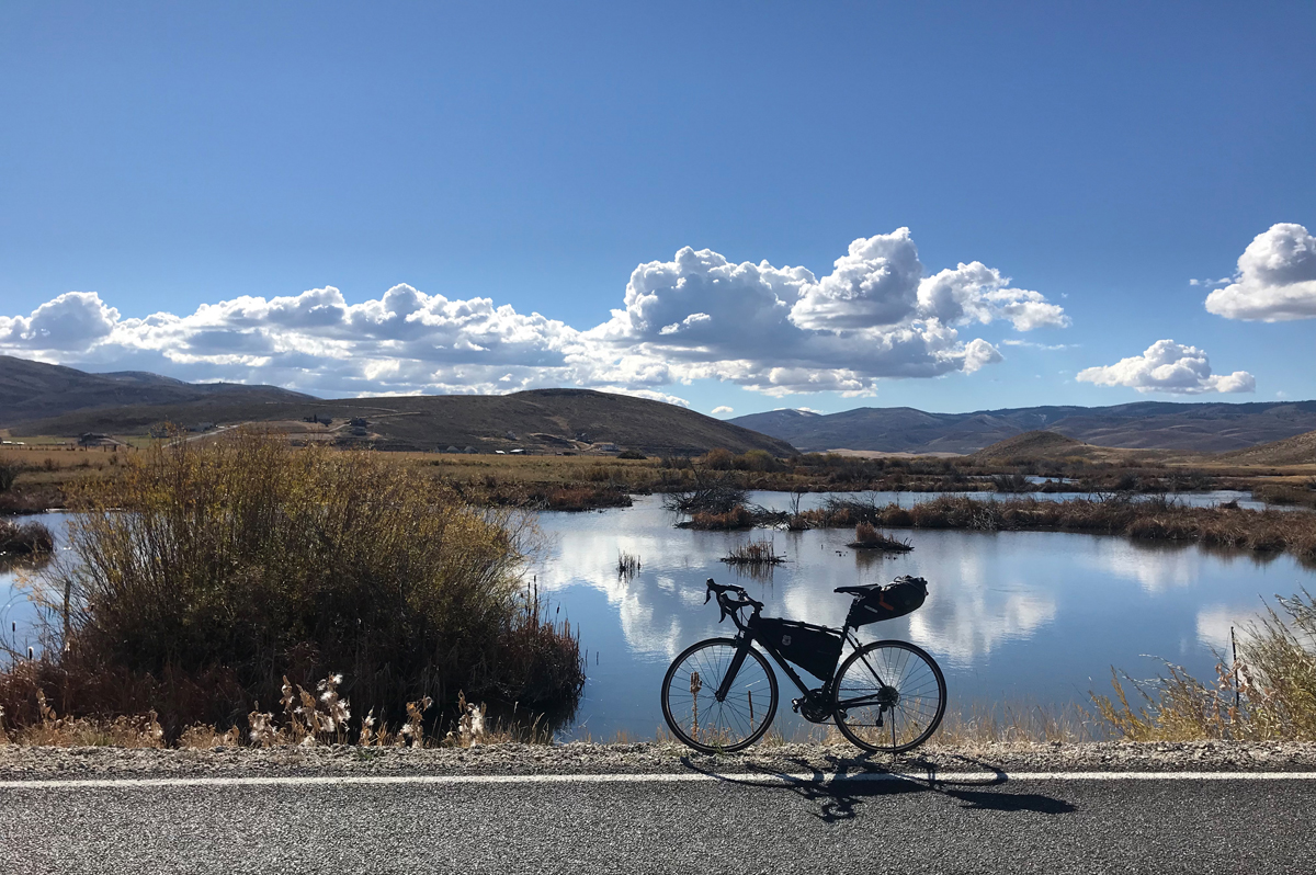
Eden to Bear Lake
- Route: Eden, Huntsville, Monte Cristo, Woodruff, Randolph, Garden City, 102 miles
- Terrain: Alpine terrain marked by multiple climbs and descents including miles of riding higher than 9,000 ft. above sea level.
- What to See: Mountains (Wasatch and Monte Cristo ranges); high mountain meadows loaded with wildlife and colorful wildflowers; distant vistas and repeating mountain ranges layered on the horizon; rural farm towns; ranchlands; barns and out buildings; hiking and snowmobiling trailheads; a ride along one of the most beautiful lakes in the western United States; Bear Lake is a blue marble plopped down in the middle of a memorable valley, surrounded by alpine mountains. Nothing quite like it.
- Selfies and Photo Ops: Eastern rim of Pineview Reservoir with the collection of Snowbasin Ski Resort’s peaks in the distance; an archway of deer and elk antlers in the front yard of a local rancher (at the turn-off for Causey Dam, across the street from Sill’s Cafe); river side stops with dramatic foothills and cliffs throughout the first canyon entry (about miles 8-12), high mountain vistas on top of Monte Cristo (9,000+ ft.), smiley barn just outside of Randolph on the west side of Hwy 16, the miles along the southern and southwestern shoreline of Bear Lake from Laketown to Garden City.
- Wildlife: Elk, deer, birds of prey, buzzards, fox, coyotes, beaver, trophy fish, black bears, badgers, jackrabbits, raccoons and little ground scurriers.
- Best Post-Ride Eats: Cody’s Gastro Garage in Garden City. A converted mechanic’s garage (complete with a couple of hot rods on lifts inside the restaurant). Open year round and a great place to tuck into two or three pounds of wings (be sure to get the raspberry chipotle sauce for the wings – the area is famous for mountain raspberry farms). If you do this ride in reverse and end up in Eden, grub-up at Carlos and Harley’s Fresh-Mex Cantina. It’s loaded with mountain vibe, delicious chow and chilled drinks for every fancy.
- Still Have Legs, Lungs and Sunlight? Turn east on Hwy 30 at Sage Creek Junction and follow the road to Cokeville Wyoming. The road skirts Cokeville Meadows National Wildlife Refuge for miles. It’s a 70 mile round trip detour all the way to Cokeville and back, but you can bite off as much as you want to chew.
- Note: The road through the Monte Cristo Mountains is closed during winter months and although snowmobiles often gather at the entry gate to explore the area, cyclists should not be tempted to cross through the closed gate since the passage is often dangerous and/or impassable for bicycle travel. Also, cell coverage is not available for about 30-35 miles (from about halfway to Causey Dam from Eden, through Monte Cristo, until the final descent into Woodruff).
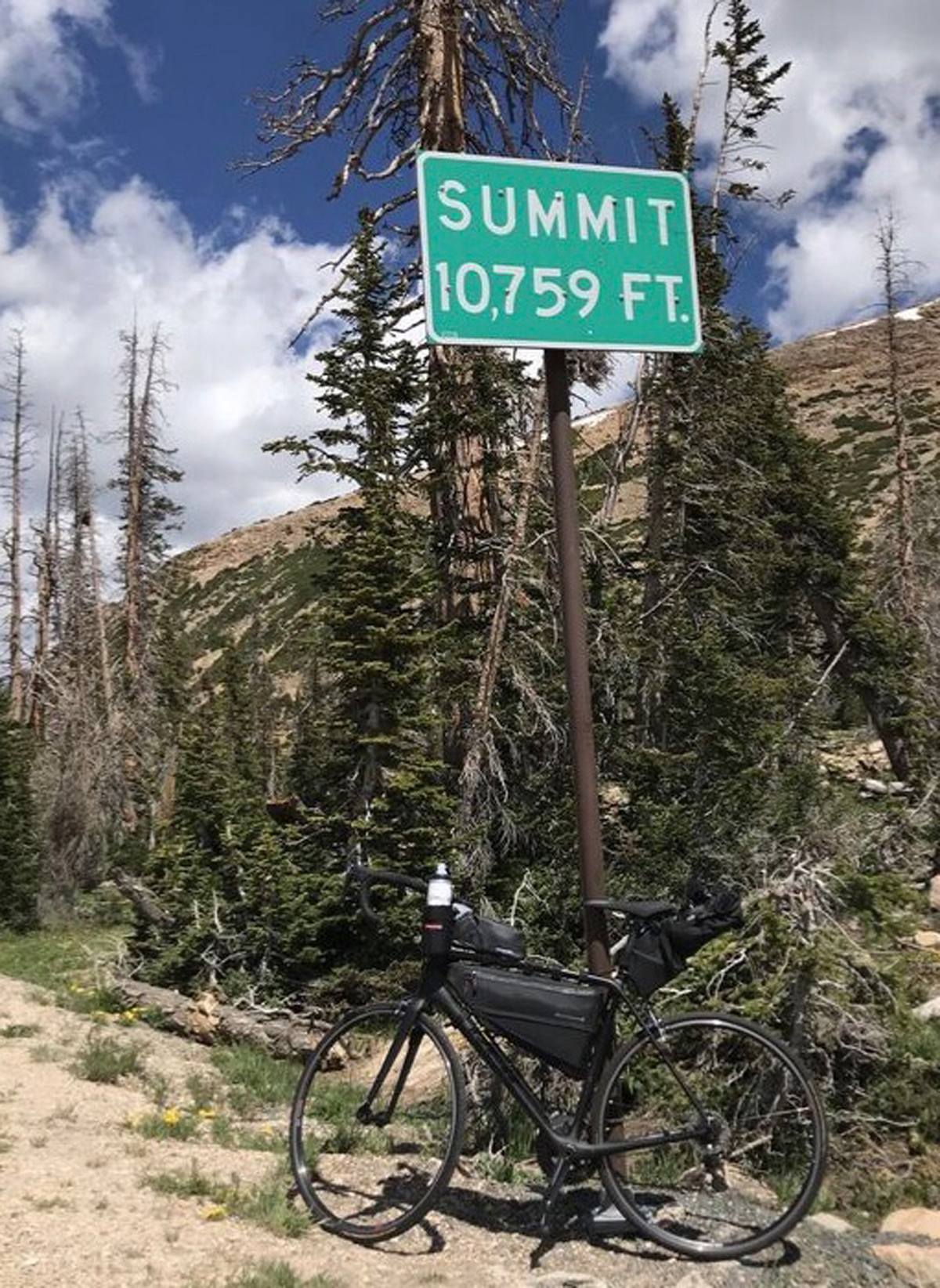
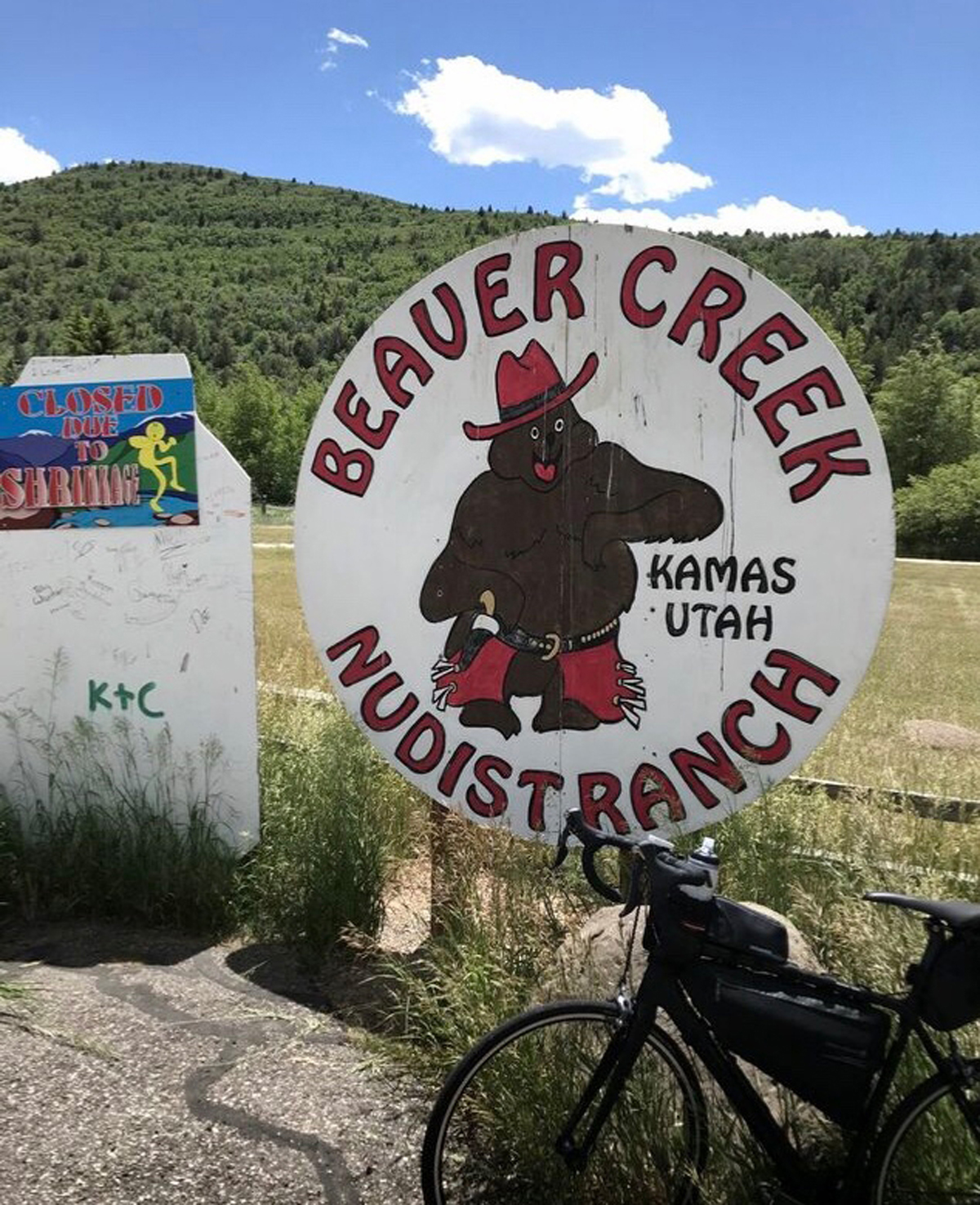
Park City and the High Uintas
- Route: Park City, Deer Mountain, Hideout, Kamas, Mirror Lake Highway past Iron Mine Mountain, Upper Provo Falls, Bald Mountain, Mirror Lake and back. Riders looking for a one-way adventure may continue on past Mirror Lake and finish in Evanston, Wyoming. 100 miles
- Terrain: Alpine terrain marked by multiple climbs and descents. Ride begins at 7,000 ft. above sea level and peaks out at 10,759 ft. above sea level on the highest paved road in Utah. The ride features 7,500 ft. of high altitude ascent.
- Wildlife: Elk, deer, moose, birds of prey, buzzards, ducks, geese, fox, coyotes, beaver, trophy fish, black bears, mountain lions, badgers, porcupines, snakes, jackrabbits, raccoons, mountain goats, pica, and other little ground grounders.
- Best Post-Ride Eats: Freshies in Park City. The owners are nationally known for their lobster rolls (yep, award winning lobster in Utah). They are made with lobster tail and knuckle claws flown in from New England. These rolls compare favorably to my favorite lobster pound in Trenton, Maine. Oh, and don’t miss the blueberry pie – it’s made with those little tiny wild blueberries like they serve in the best bakeries in Bar Harbor.
- Still have Legs, Lungs and Sunlight? Take a detour through Heber City, home of the Heber Valley Airshow and Heber Valley Railroad (a heritage railroad with two 1907 Baldwin steam locomotives). While you’re there, checkout Midway (right next door) and soak your bones in the 90 degree waters of a geo-thermal caldera, but you may not have the will to return to the saddle afterwards. That’s okay, get a room at The Homestead Resort and finish your ride the next day. The detour adds approximately 40 miles.
- What to see: Mountains (Wasatch and Uinta ranges—Uinta range is a subrange of the Rocky Mountains and is unusual for being the highest range in the contiguous United States running east to west); Jordanelle State Park and reservoir; world-class fly fishing Provo River; high mountain meadows loaded with wildlife and colorful wildflowers; distant vistas and repeating mountain ranges layered on the horizon; Upper Provo Falls; Mirror Lake, a high mountain lake stocked with rainbow, brook and tiger trout and named for the near-perfect reflection of surrounding mountains and trees; rural farm towns; ranchlands; barns and out buildings; hiking and snowmobiling trailheads.
- Selfies and Photo Ops: Tranquil Silver Creek ponds along the Historic Union Pacific Rail Trail (plenty of wildlife activity in the early morning hours); Park City Ice Arena and Sports Complex; Northern rim of Jordanelle Reservoir with a collection of Deer Valley Ski Resort’s alpine peaks and trails in the distance (be sure to look behind you as you climb past Jordanelle in the early morning hours, especially just before dawn); Beaver Creek Nudist Ranch road sign – about 30 years ago somebody added “Nudist Ranch” on the bottom of the Beaver Creek sign); the Provo River flowing alongside the Mirror Lake Highway climb including Upper Provo Falls; Lilly Lake; the “SUMMIT 10,759 FT” sign; Bald Mountain and Mirror Lake.
- Note: Cell coverage is not available past Kamas. Also, Mirror Lake Highway, is closed during winter months. Check the local weather forecast before you ride and be prepared for quickly changing conditions.
Over the Border
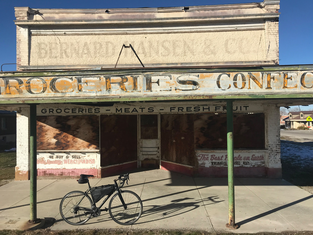
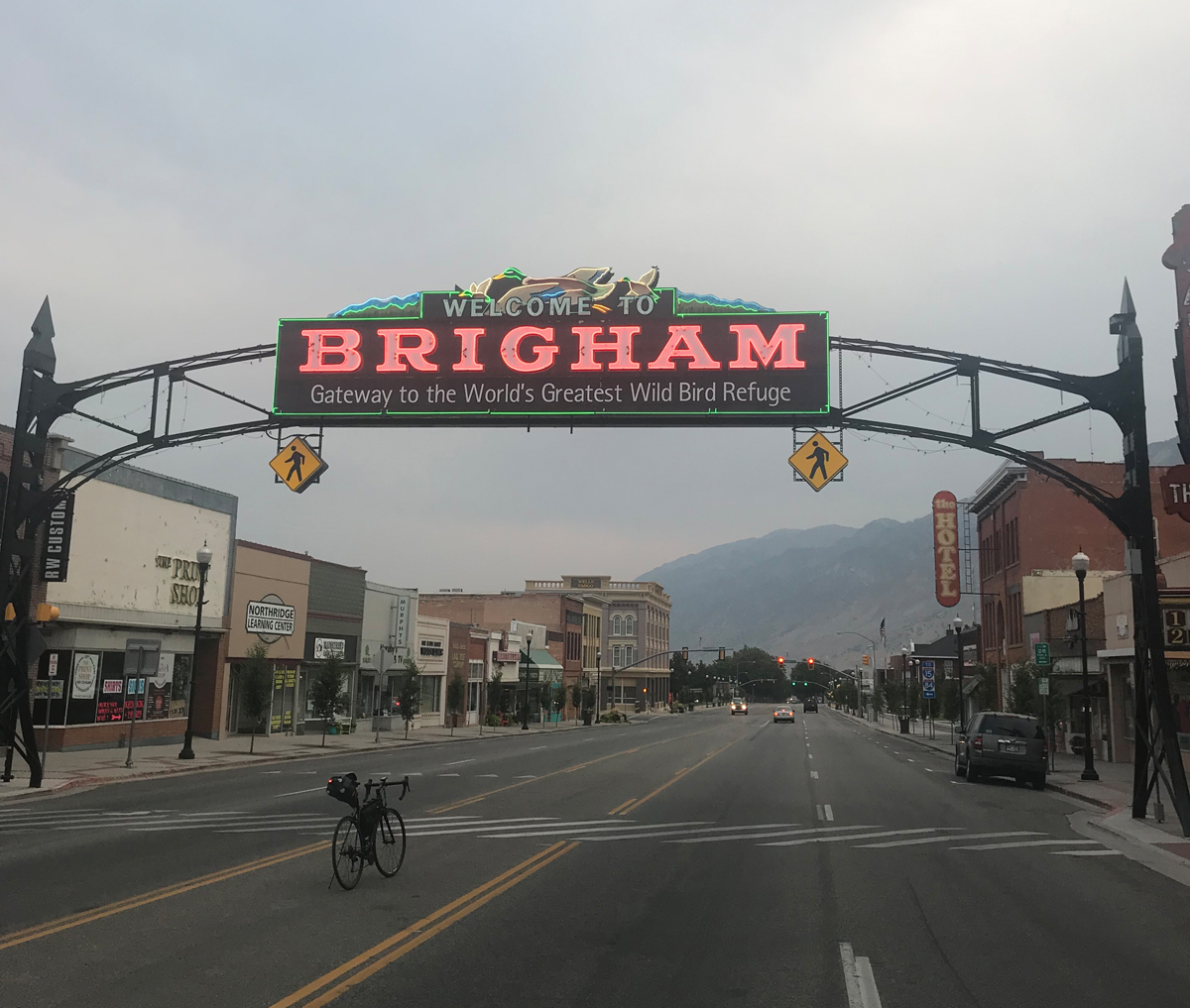
- Route: Ogden, Brigham City, Corrine, Tremonton, Riverside, Collinston, Petersburo, Newton, Trenton, with quick detour to Clarkston and back, Cornish, Preston—the first town in Idaho after crossing the border (one way). 101 miles
- Terrain: Early route through city suburbs, long streaky roads lined by regal mountains, rural valleys, mountain pass, historic river sites, farmlands.
- What to See: Historic Bear River City (home to first recorded white man discovery of the Great Salt Lake, although it was thought to be the Pacific Ocean); defunct U and I sugar factory; old stomping grounds of famous mountain men and fur trappers; mountains and valleys typical of the intermountain region; big game; farmers working their craft (or silent fields in the off-season with farm machines parked and waiting—livestock wandering nearby, wondering when the next feed is scheduled). As you pedal by, try your best/loudest mooo, whinnie or bray, see if you can get livestock to respond.
- Selfies and Photo Ops: Martin Harris (early senior Mormon leader) gravesite in Clarkston; Bear River City historical marker featuring mountain man Jim Bridger story; old Bernard Mason and Co. Grocer façade on Main Street in Bear River City; U and I Sugar mural in Garland; the gap in distant mountains as you head east toward the mountain pass a few miles after the turn in Riverside; Welcome to Idaho sign; quaint store fronts and buildings featured in Napoleon Dynamite (the lead character is depicted in the film as being from Preston and most of the movie was shot in Preston).
- Wildlife: Elk, deer, black bear (although remote chance to see bears close to the road), birds of prey, beaver, muskrat, waterfowl, otters, snakes, fox, coyote.
- Best Post-Ride Eats: It’s an Idaho farm community but you can find a pretty decent pizza at Sporty’s on Main Street in Preston. They are cyclist friendly and are anxious to fill your belly with all things pizza. They’re generous with toppings–just tell ‘em to cover it with meats and stuff. You might be surprised how good a post ride pie can be chased by a cold Mountain Dew or two and accompanied with some greens.
- Still Have Legs, Lungs and Sunlight? Head 60 miles north after a brief stop in Preston and finish your long day at Lava Hot Springs Resort. The healing waters of Lava will be a perfect way to celebrate your brevet. Congratulations, you are now an informal randonneur plus.
- Note: If you ride due north from Brigham City (rather than slipping over through Corrine before heading north again) you’ll cover fewer miles and see fabulous mountains up-close and you’ll pass by Call’s Fort Monument, an important roadside landmark related to early Utah history.
Riding the Shelves
- Route: Payson to Richfield (one way), 101 miles
- Terrain: Rolling plains from shelf to shelf to shelf to shelf, you get the picture.
- What to See: Lavender fields (stunning color near Mona if you ride when the lavender is in bloom); Mount Nebo, the highest peak in The Wasatch; tiny quaint townships including Mona, Levan and Salina; long stretches of semi-arid rolling plains through huge swaths of BLM lands; valley after valley lined with mountains running north and south all the way to your destination; rural homesteads and old pioneer buildings slowly crumbling under the bright sunlight (seems like this place has 365 days of blue skies each year, surely that’s an exaggeration, but it probably won’t be difficult to find a day drenched with sunshine); windswept vistas; tempting turns into feeder canyons and periodic arroyos.
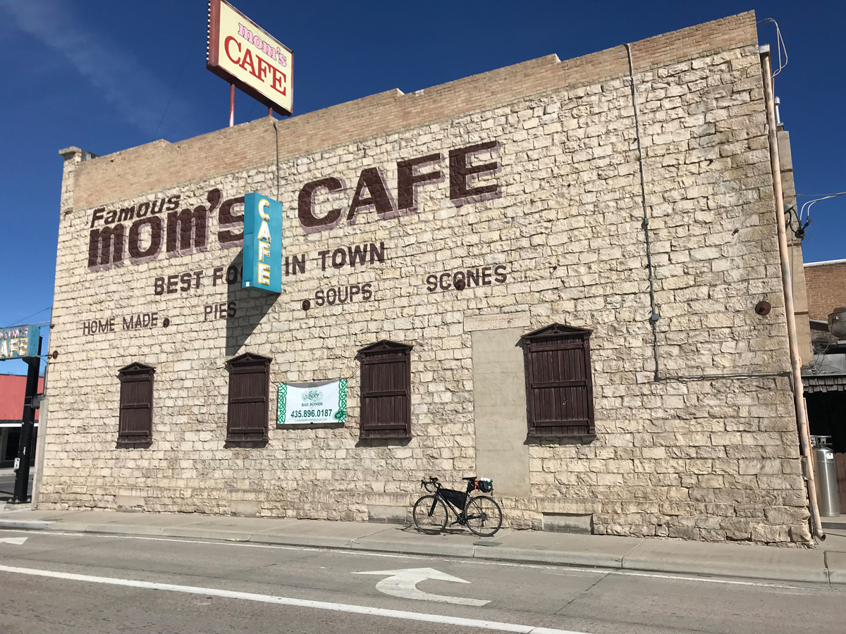
- Selfies and Photo Ops: Historical public square tile display in Gunnison; lavender fields near Mona (especially during bloom season); long empty road looking north with Mount Nebo on the horizon and the road disappearing into infinity; dilapidating pioneer era out buildings strewn along the way; Famous Mom’s Café mural in Salina; Welcome to Mona sign with elk and tree silhouette (north entry into town).
- Wildlife: Rabbits, coons, deer and elk, snakes and lizards, birds of prey, waterfowl, and buzzards.
- Best Post-Ride Eats: Sagebrush Grill on Main Street in Richfield. Get the House Blackened Ribeye with roasted garlic bleu cheese butter and have them top it off with a scoop of blue crab if it’s in season. Best proteins in the region.
- Still have Legs, Lungs and Sunlight? Turn east at Gunnison and ride to Sterling, a fabulous 14 mile detour featuring memorable geology, water pockets, and farmlands.
- Note: Pay attention to the local wind forecast. Steady winds may be relatively safe but sometimes parts of the ride can whip up gusts that may prevent safe passage, especially if they are crosswinds.
Rockets and Cattle
- Route: Brigham City, Corrine, Howell, Snowville (and back). 104 miles
- Terrain: Mostly flats, some rolling hills, one minor mountain pass
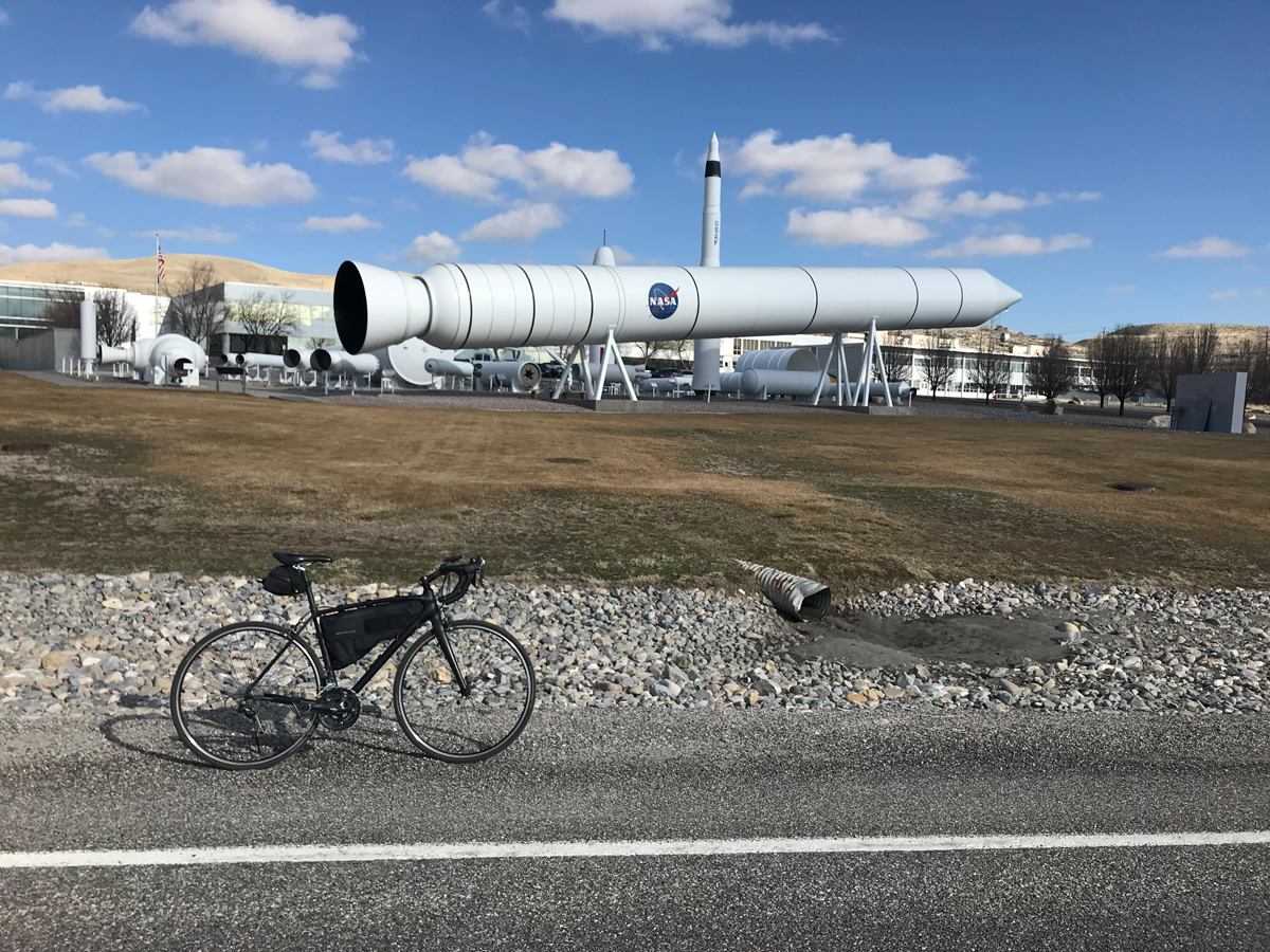
- What to See: Horizons loaded with mountains and hills including the Wasatch, Promontory, Blue Spring and Hansel Mountains; wetlands and the Bear River Migratory Bird Refuge; long stretches of grazing cattle and farmlands; Howell (tiny cowboy town); Snowville township (named after early Mormon leader Lorenzo Snow); Rocket Garden at Northrop Grumman’s base (rocket display is free to the public and includes a space shuttle booster and patriot missile).
- Selfies and Photo Ops: Roadside water strips throughout the bird refuge; Rattlesnake Pass; NASA and USAF rockets; roadside cattle who seem to have a knack for photobombing; Welcome to Howell sign on the northern end of town and the Bernard Hansen and Co. Grocery storefront in Bear River City (see Still Have Legs section below).
- Wildlife: Migratory birds, birds of prey, coyotes, deer, rattlesnakes and various little furry fellows.
- Best Post-Ride Eats: Maddox in Brigham City. Famous fried chicken (on my top five list for best fried chicken in America) and they serve delicious steaks in a casual ranch style setting. Be sure to get a piece of banana cream pie – a delicious finisher and a house specialty.
- Still Have Legs, Lungs and Sunlight? Turn north at Corinne and ride to Bear River City (total ten mile detour there and back to route). To settle a wager, old west mountain man Jim Bridger floated down the Bear River in a bull boat to discover its outlet. His 1824 journey was the first recorded white man discovery of the Great Salt Lake. His termination point is nearby the small town. While you’re there, check out the old storefront of the Bernard Hansen and Co. Grocery stand before it’s gone. It still stands proudly in the afternoon sun but appears to be on its last legs –looks like it belongs in a ghost town.
- Note: Part of the ride is on Interstate 84, which has generously wide shoulders and is usually clear of debris, stickers etc.
David Collins is a cycling enthusiast and amateur randonneur. Follow him on Instagram @rockypumpkin.