cycling utah October 1999
By Jan Yeckes, Jim Byrne, and Rob MacLeod
Steiner-Centennial trail section is close to home for many
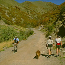
This month's trail is very close to home for those of you who live along the Wasatch Front. The Bonneville Shoreline Trail is an urban interface trail that provides the best of both worlds-a great ride in the foothills of the Wasatch Mountains with magnificent views of the Salt Lake Valley below, and all accessible from your home. This time of year the foliage in its autumn glory, late-blooming wild flowers, and pleasant weather make riding the Bonneville Shoreline Trail (BST) particularly appealing. This combination of easy access and scenic autumn riding create a winning formula for October's trail of the month.
The BST offers a variety of technical difficulty, but without any white-knuckle descents to worry about. Some sections appeal to the more casual trail rider or beginner, while others demand a bit more fitness because of sustained climbs and the odd technical switchback. It is a great get-away without really having to get too far away-the perfect choice for a ride after work or even during your lunch hour!
The Bonneville Shoreline Trail is a variable width, dirt and rock surface trail that generally follows the shoreline of the ancient Lake Bonneville-look for the BST signs to help guide the way. Large wooden posts mark all the trailheads and brown fiberglass signs mark the trail itself. The BST is used by hikers, runners and, in some areas, equestrians, so make sure to share the trail. Cyclists must yield to all other trail users-standard practice on all multiuse trails. And, of course, respecting the rights of private property owners close to the trail will help to ensure continued bike access along the BST.
This article contains a description of the Steiner-Centennial section of the BST, which was officially dedicated in June of this year. This 13 mile section stretches from Pioneer Trail State Park (This is the Place) at the head of Emigration Canyon to Davis County. Accessible by ten designated trailheads, this section of the BST is ideal for a full-length ride, as well as shorter trips between various points on the trail.
From the east end of the Pioneer Trail State Park (across from Hogle Zoo), the trail winds initially steeply up and around the park through the gate in the chain-link fence to the U of U Research Park, past Red Butte Gardens, and continues above the U of U Hospital complex (the lower trail is currently blocked by construction, so take the higher trail). Just to the northeast of the University Hospital, you will find the mouth of Dry Creek Canyon. Fork east (right), up the drainage, to stay on the BST (the road to the west will take you to the Block U, into Popperton Park, and to the 11th Avenue bikeway.)
The climb up Dry Creek is one of the most enjoyable trail segments, with a twisty but not technical steady climb that crosses the stream bed several times until you reach a more technical single switchback heading west (left) up the ridge. From the top of the switchback at Lime Kiln Gulch saddle, you get the first of many spectacular views of the Salt Lake Valley. Here the trail begins to wind its way northwest above the Avenues, crossing Spring Gluch, Perry's Hollow, and the "Bobsled Run" (for hard-bodies only). This section is mostly gradual climb with one sustained steeper segment to reach the City Creek saddle at the top of the Bobsled Run. From here there is access to Little Black Mountain and stunning views of City Creek Canyon.
The trail drops off the ridge to the west on an old jeep road to the trailhead at the top of Terrace Hills Drive. At 2/3 of a mile down, watch for the sharp right turn off the jeep trail to bypass the trailhead. This trail continues west in the direction of the steel water tank, west of Terrace Hills Drive. Then follow the "ditch" initially west, to several great overlooks, then around the bluff to a descending trail, which takes you down to the meadows north of Morris Reservoir (the finest open meadows left on the Bonneville Bench in Salt Lake City).
From here, the trail crosses the meadow to drop into City Creek Canyon. The trail descends steadily with one sharp switchback (watch out for this one!) to the trailhead next to the retention pond at the intersection of North Bonneville Drive and City Creek Canyon Road. A good loop opportunity goes from here back along the 11th Ave. bikeway to Dry Creek Canyon access via Popperton Park.
West of City Creek, the trail is temporarily closed to cyclists due to a rock slide last spring and some unresolved access restrictions. While the trail is closed you can access the continuation of the BST, via Dorchester Road, north of the State Capital. The trail continues from there via dirt road past the first set of radio towers to Bountiful Blvd. in Davis County.
Here are some basic trail facts to help you plan your BST Steiner Centennial Ride.
Length of ride: 13 miles one-way, or shorter trips between any of ten trailheads along the route. A loop from Dry Creek to City Creek and back along the 11th Avenue bikeway makes a nice 2-hour adventure for beginner and intermediate riders.
Elevation change: The highest point of the trail, at the City Creek Saddle, sits 540 ft above the mouth of Dry Creek Canyon and 920 ft above the City Creek Trailhead.
Physical difficulty: Generally easy to intermediate with some sustained climbs and several steeper switchbacks.
Technical difficulty: beginner to intermediate.
Landmarks along the way: Who could resist exploring areas with names like Soldiers Hollow, Red Butte Creek, Battle Gulch, Cephalopod Gulch, Dry Creek, Limekiln Gulch, Spring Gulch, the Quarry, Twin Peaks, Perry's Hollow, and Morris Reservoir?
Of Special Note: Shared Use Etiquette Applies! Dogs must be leashed, cleaned up after, and are not allowed into Pioneer Trail State Park.
IF YOU RIDE IT, HELP MAINTAIN IT: There are trail construction and maintenance parties most Saturdays during the spring, summer and fall. For details (and lots of other useful information, maps, and photos), please check the Bonneville Shoreline Trail Committee web site (www.bonneville-trail.org) or call trail construction coordinators Kathleen and Marv Stoddard at 485-6975.
 Back to Home Page