The Salt Lake City and Salt Lake County Bikeways Map has been updated and rereleased for 2019. The 24×36 inch map shows routes for cyclists throughout the city along with bike shop locations, bmx/skateparks, parks, and other locations relevant to cyclists. The map is free and copies can be obtained at Salt Lake City and County bike shops and other locations in the Salt Lake Valley.
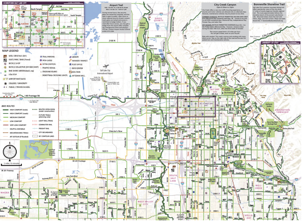
The map has many new features including new safety information and graphics, and new bike infrastructure added since 2017. But, the biggest change is that the new version of the map designates bike routes in terms of comfort levels for cyclists rather than whether or not there are bike lanes on a particular street.
The comfort rating seeks to give people information about the type of experience to expect. Salt Lake City adapted the comfort rating from the Austin, Texas bike map and applied their descriptions to Salt Lake City streets. Several regular bicyclists on staff worked on the initial ratings, and the ratings were also critiqued by the City’s Bicycle Advisory Committee. High comfort routes include trails, very low traffic roads, or bikeways with separation from traffic. Most regular bike lanes on streets with typical city traffic are rated as medium comfort. Higher-speed and higher traffic streets, even with a bike lane, may be rated low comfort. A few critical connections are rated as extremely low comfort, such as a hairy section around a freeway interchange. The map legend explains these in further detail.
The recreational routes section that was on the 2016 map was removed, which included are Emigration Canyon, City Creek, Salt Lake Marina, and the Cycle the City Route, a site seeing route in the core of the city that highlights historic sites and urban trails.
The recreational routes are available online:
- Cycle the City Geo-PDF Map
- City Creek Canyon Geo-PDF Map
- Salt Lake Marina Ride Geo-PDF Map
- Emigration Canyon Geo-PDF Map
The map is free and copies can be obtained at Salt Lake City and County bike shops, on some UTA buses and trains, the information desk at the Salt Lake City and County Building at 451 S. State, and from Salt Lake City sponsored booths at various festivals throughout the summer. It is also online as a pdf at slc.gov. The pdf is geotagged so that it can used on a smartphone to show location and other relevant information. The map was produced by Salt Lake City in conjunction with Salt Lake County, the University of Utah, UDOT Travelwise, and UTA to create a combined map covering the entire country.
Hardly seems right that UDOT would have their logo on the front of the map as they’re definitely not friendly to anything other than cars