cycling utah May 1999
Casto Canyon is the legal alternative to Bryce Canyon
Click here for a Topo Map of this trail
By Gregg Bromka
Excerpted from Mountain Biking Utah--Revised 2nd Edition (publication date May 1999), by Gregg Bromka.
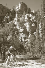
It would behoove you to visit nearby Bryce Canyon National Park while in the Panguitch area, for it is truly a magical place. But try biking any trail in Bryce Canyon and you'll find yourself counting bricks inside the town pokey because, as we all know, it's illegal. Instead, head north by northwest to Casto Canyon to bike through scenery that is positively "arresting," without assuming the risk of being busted.
Like Bryce, Casto is a phantasmagoria of peculiar shapes and blazing color etched from the Claron Formation's flesh-toned limestone. Your imagination will run wild as you pedal past crinkled walls, multi-tiered pillars, and bulbous spires - all the color of glowing embers. But unlike the national park, however, fat tires are welcome in Casto Canyon. In fact, in 1992 the Powell Ranger District upgraded Casto Canyon from an overgrown cattle path to a bonafide multi-use recreational trail. A small parking area, horse staging ramp, and an outhouse were constructed, and the once-primitive trail weaving up Casto was widened to accommodate ATVs. But these improvements did not change Casto's testy demeanor, especially for bicyclists.
Notes on the trail:
Casto Canyon Trail is typically ridden as a 7-mile out-and- back excursion - perfect for intermediate to adventuresome novice bikers. An extended route, described here, incorporates a challenging side loop up to Barney Cove where you can view Casto from afar and survey the surrounding terrain.
From the outset, the trail wavers up the canyon in a futile attempt to remain on the creek bed's firm bank. However, on nearly every meander, the trail dives off the embankment into the bouldery channel. When dry conditions persist and the creek is parched, which is the norm, the channel-bound trail segments are packed sand, mostly ridable, and good-old butt-spanking fun. But when rain falls, runoff carries loose sand and rocks down the creek, erasing portions of the trail. Then you are forced to dance a technical jig until subsequent travelers pack down the path again. That's how the game is played on this pesky little trail: pedal easily on terra firma, cant-and-ratchet across the rocky creek bed, repeat.
Gradually, the canyon's tall corrugated walls subside to low rounded knolls, and the redrock loses its intricate shapes and flaming color. When you reach the junction signed for Sanford Road, Losee Canyon, and Red Canyon after about 3.5 miles, fork left/north and climb the steep, rough ATV track 1.5 miles up a side canyon. (This is the turnaround point for novice riders on the standard 7-mile out-and-back tour.) At the top of the climb, turn right twice and take the Sanford Road/Fremont ATV Trail southward across Barney Cove-a treeless bench extending from nearby Casto Bluff's ragged volcanic abutment. Descend the curvy doubletrack nearly 4 miles until it bottoms and bends sharply left across upper Casto Canyon. Reenter Casto by following the faint doubletrack to the right, which soon narrows to a braided cattle trail. (The lower ATV trail has not been pushed this far up the canyon.) Duck under juniper and pinyon boughs, and then boogie down the drainage-dodging ever-present cow-pies.
Butch Cassidy and the Wild Bunch eluded the law in Casto Canyon. A rock hut that Butch purportedly inhabited has since crumbled and vanished. Pioneers also inhabited Casto. The dilapidated wood-plank structure about one-half mile down Casto Canyon from Sanford Road is a remnant saw mill.
Pass the junction for Cassidy Trail/Losee Canyon (forking left) and arrive at the junction for Sanford Road you encountered when you began this side loop. Then admire the park-like scenery from a new perspective, while retracing your tracks down Casto Canyon to the trailhead.
Want to log more miles? Strong riders have two options from upper Casto Canyon: follow the Cassidy Trail south to neighboring Losee Canyon or take Forest Road 121 to Red Canyon. If you pursue either, you will loop back to Casto on the access road.
The former, Cassidy Trail, is a temperamental path that is used infrequently by equestrians and less by bikers. Although it is highly scenic, it is technical difficult and tough to follow. But if you're good at sniffing out a trail, you can ride 4 miles on Cassidy, descend 3 miles through Losee, and loop back to Casto for a 13-mile loop.
The latter follows doubletracks southward to UT 12 in Red Canyon. Stay southbound on the Sanford Road/Forest Road 121 and grind up the steep 1.5-mile-long hill in Tent Hollow. After reaching the top and descending another mile to a prominent junction, fork right on Forest Road 121 for Cabin Hollow and UT 12. (Forest Road 120 forks left for the Fremont ATV Trail). Descend 4 miles to UT 12, coast 3 miles through Red Canyon, and take the access road 3 miles back to Casto for a 20-mile loop. You'll be rubbernecking the whole way down Red Canyon.
Just the facts:
Distance: 14 miles; out-and-back with loop
Tread: ATV track, doubletrack, primitive singletrack
Physical Difficulty: Intermedi-ate (gentle climb up Casto Canyon, but rough and tough when crossing the dry, bouldery creek bed; moderate climb to Barney Cove)
Technical Difficulty: Moderate (easy going on the creek's embankment; lumpy and bumpy when crossing the sandy, boulder- filled creek bed; sometimes rough descending on Sanford Road)
Elevation Change: The Casto Canyon trailhead is at 7,080 feet. The trail rises to a highpoint on the Sanford Road of 8,255 feet for a total gain of about 1,200 feet.
Trailhead Access: From Panguitch, take US 89 south 7 miles; then turn left/east on UT 12 for Bryce Canyon National Park and Escalante. Before entering Red Canyon, turn left/north near milepost 2 for Casto and Losee Canyons. Take the gravel road 3 miles to the Casto Canyon trailhead, passing Losee Canyon after 2 miles.
 Back to Home Page