cycling utah May 2000
Logan River Trail is a perfect lunchtime getaway
By Gregg Bromka
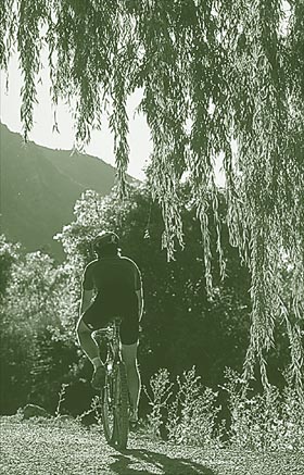
The easily accessible Logan River Trail is a model that every city should duplicate. Recreation paths, like this one alongside the Logan River, increase the quality of life by providing a quick, temporary escape from the confines of urbanism.
On the Logan River Trail, you are comforted by the river's rushing sounds, by breezes wafting through thick riparian growth, and by an array of animals, waterfowl, and fish that rely upon the river for habitat and sustenance. Logan River Trail can be a quick lunchtime spin, a tension breaker after work, or a family retreat on the weekend.
From the outset, the route follows a dirt and gravel road that is used for maintenance access. It then narrows to a wide single path.
The riverside foliage that drapes the trail muffles the steady drone of motor vehicles traveling the highway just a stone's throw away. After about one-half mile, you pass the Stokes Nature Center, which is open by reservation.
You then pass the Red Bridge Trailhead and information board. Chalk dust smudged on large boulders tucked in the trees is a tell-tale sign that technical rock climbers favor the calcareous quartzite cliffs of Logan Canyon for its steadfast handholds.
Two miles into the ride, the path narrows to singletrack. It rises steeply above the river to a level where you can view the craggy canyon over the tops of riverside trees. This section is a good test for first-time bikers and children, and it may slow the progress of those with tagalong child trailers.
Descend a fun little stretch back to the riverside and pass the Gus Lind summer homes area. Pass Third Dam, where anglers and waterfowl congregate, and then arrive at Spring Hollow Campground near site No. 3.
The trail continues upstream as the Logan Riverside Nature Trail, but bikes are prohibited on the footpath. Make an about face and retrace your tracks to the trailhead while admiring the river from a new and varied perspective.
The river, canyon, and nearby city all share the same name: Logan. But who, or what, was Logan? According to Van Cott's Utah Place Names Logan may have several origins.
One claim is that Logan was the name of an Indian chief who befriended the fur trappers. An entry in the Utah State Historical Society Archives states that a pioneer farmer had an old work ox named Logan and the town was thus named. The most credible and generally accepted account is that the area was named after Ephraim Logan, a mountain man who trapped with General William H. Ashley and Jedediah Smith. Logan was killed by Indians in 1920 and was buried in the mountains near Logan Canyon.
Just the Facts:
Distance: 7.5 miles, out-and-back.
Tread: Gravel and native surface multi-recreational path and hand-built singletrack.
Physical Difficulty: Easy. Much of the trail follows the bank of Logan River. One section, midroute, rises steeply above the river. Although it's a short diversion, it will challenge novice riders and children.
Technical Difficulty: Low to moderate. The trail along the river's side is a piece of cake. The short uphill singletrack section midroute is a bit more challenging but nothing daunting.
Elevation Change: The lower trailhead is at 4,720 feet. The upper trailhead (Spring Hollow Campground) is at 5,020 feet. Adding in a short climb midroute, total elevation gain is merely 400 feet.
Trailhead Access: From the center of Logan, travel 2 miles east on 400 North/U.S. Highway 89 to Logan Canyon. The trailhead is .7 mile up canyon from where the highway crosses Logan River. Look for a steel gate on the right. Parking at the trailhead is limited to a few vehicles, so park at the pullout on the left/north side of the highway, before the trailhead, near the Cache National Forest sign just past milepost 375. (Use extreme caution crossing the highway to the trailhead.)
Excerpted from Mountain Biking Utah, 2nd Edition 1999, by Gregg Bromka: www.offroadpub.com/titles/1037.htm
 Back to Home Page