cycling utah March 1999
Zion’s neighbor: Gooseberry Mesa
Click here for a Topo Map of this trail
Excerpted from Mountain Biking Utah--Revised 2nd Edition, 1999
By Gregg Bromka
Remember the "olden days" when the very mention of Slickrock electrified the air with both first-hand and rumored accounts of outrageous riding experiences on the petrified dune, when you eagerly passed up that late-season powder for the springtime pilgrimage to Moab--mountain biking's promised land? Mountain biking, slickrock, and spring: what could be better?
Recently, the locals in St. George have been beating their chests about an elusive trail system that, too, has slickrock. "Eh, been there done that," you say? How about slickrock mixed with bonafide singletrack? Can't find that in Moab, so let's talk.
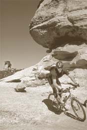
It's true. Tucked away neatly on the end of Gooseberry Mesa, located a stone's throw from Zion National Park, you'll find a serendipitous track laid out amidst the sage, juniper, and ponderosa. Granted the slickrock is not the free-flowing catch-a- wave expanse that hallmarks the original formula in Moab. But Gooseberry's recipe is every bit as tasty and requires a full repertoire of riding skills to clean the hundreds of audacious stunts. While you're not "busting a cog" on the rock, you're twisting a number on soft, loamy, one-laners coated with crunchy pine needles--not the runaway bike ramps-cum-sand traps of the Moab variety. This is the real stuff that will satisfy any singletrack purist. On Gooseberry, you get your cake and can eat it too.
Oh, you want scenery, too? Well Gooseberry serves up some real beauts that will seduce the lens of any shutterbug. On the mesa's rim, you toe the edge of southern Utah's Grand Staircase and gaze upon its successive rungs, each named for the distinctive colors of the rocks exposed. Mark this trail for late afternoon when the sun starts its westward arc and intensifies the hue of each step and fills crevasses with slivers of darkness.
Notes on the trail: The Gooseberry Mesa trail is difficult to follow and even harder to describe. Trail markers consisted of sometimes sporadic and faded dots painted on the slickrock and a consensus of tire tracks on the singletrack. The Bureau of Land Management may adopt and develop this trail in the future.
From the parking area at the cattle guard, head south on singletrack through the sage then into juniper, pinyon, and scattered ponderosa pines. While hopping over bands of sandstone, scan the ground for green dots painted on the rock. After 1 mile, the trail bends northward and rises up a ledgy slickrock ramp to an ill-defined junction. If you're beaten to a pulp already then bail out (right) to the mesa's central doubletrack. If you're foaming at the mouth for more technical treats then fork left. About .5 mile farther, the trail bends left around a prominent overhanging point called Wedding Rock.
The trail forks in the conifers ahead. Stay straight for the easier shortcut, or fork left to face the Staircase. Where the trails rejoin, head westward across a section of slickrock potholes marked with white dots. Intersect a doubletrack and take it right/north a few hundred yards; then fork left to continue on the green-dot trail (or bail out by taking the doubletrack to the mesa's central road.) One mile farther the trail reaches and follows the 500-foot-high rim of Gooseberry Mesa. Follow the rim trail to an improbable maneuver that goes by a variety of cursed names (most commonly The B--, rhymes with "itch"); then practice your short radius turns and track stands while reconnoitering Rattlesnake Gulch.
Five miles out, the path curves northward and clips the edge of a colossal amphitheater of calico-striped slopes then intersects the end of the mesa's central road. You can reach Gooseberry's terminus and soak up stunning views by heading west from the intersection.
Just the facts:
Distance: 12 mile pseudo-loop. Allow 2-4 hours.
Tread: Intermittent slickrock and dirt/sand singletrack.
Aerobic level: Strenuous. The countless protracted rock ramps require blasts of maximum power, but you can charge full steam ahead on the singletrack segments.
Technical difficulty: Moderate to extreme. Gooseberry Mesa is every bit as tough as the real deal in Moab. If your not on top of your game, you'll walk--that simple.
Elevation change: The trail wavers between 5,100 feet and 5,450 feet, but it's nearly impossible to tally the elevation gain because of the undulating nature. By day's end, however, your legs will confirm that you've climbed a bunch.
Season: March through June and September through November. Midsummer is hot unless you start at the crack of dawn.
Services: There is no drinking water along this route. Visitor services can be found in Springdale, St. George (both have bike shops), and Hurricane (no bike shop).
Hazards: The trail itself is inherently hazardous; that's why it's so much fun. Use caution along cliff edges. The trail can be very difficult to follow and requires good route finding skills.
Getting there: Gooseberry Mesa is located 15 miles southwest of Springdale/Zion N.P. and 38 miles east of St. George. Southbound on I-15 (from Cedar City), take Exit 27 for Springville and Zion N.P. (UT 9). In Rockville, turn right/south on Bridge Street and follow the Smithsonian Butte National Backcountry Highway (light- duty dirt road) for 6.5 miles toward UT 59. Where the road flattens, turn right on the Gooseberry Mesa road.
Northbound on I-15 (from St. George), take Exit 16 for Harrisburg Junction and follow State Street/UT 9 to Hurricane. Continue on UT 59 toward Grand Canyon and Kanab for 14 miles; then turn left/north on the Smithsonian Butte N.B.H. between mileposts 8 and 9 and take the light-duty dirt road 3 miles to the Gooseberry Mesa road.
Drive 3.6 miles out the Gooseberry Mesa road (light-duty dirt road), ignoring doubletracks forking left and right, and come to a prominent Y junction (may be marked by a rock cairn). Fork left on a doubletrack and take it 1.1 miles. Park on the west side of the cattle guard/fence.
(This doubletrack may be too rough for passenger cars; if so, park near the Y junction. The Gooseberry Mesa road should be avoided altogether when wet.)
 Back to March 99 Cover