cycling utah June 1999
Logan trails add up to great riding
Click here for a Topo Map of this, and past trails of the month
Excerpted from Mountain Biking Utah revised 2nd edition
By Gregg Bromka
With its vast array of dirt roads and trails, Right Fork Logan Canyon is a nexus of mountain biking in the Logan area. The two most popular loops are the shorter (inner) Ricks Canyon-Steel Hollow and longer (outer) Old Ephraims Grave. Like two misformed eccentric circles Ricks-Steel and Old Ephraims share a common trailhead and then merge briefly at their midpoints. If you think back to high school geometry, these intersecting circles create six possible loops of varying length and difficulty. Let's not reopen the math books and agonize over the days of our youth; instead, let's just focus on the inner circle.
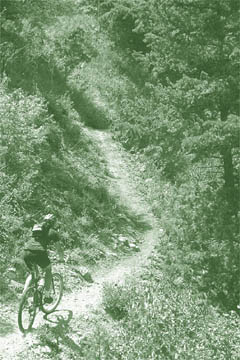
Ricks Canyon-Steel Hollow loop will satiate any singletrack purist. That is any singletrack purist with legs of steel. The ascent on Ricks Canyon Trail is no ride through the park because it rises at an average 10-percent grade over its 3.5-mile length. It starts out easy enough and well below the average, but-here we go with that math stuff again-that means farther on the grade must exceed 10-percent, right? And so it does. Just settle into your granny gear and let the canyon's lush ecosystem lull you through the toughest spots. It's a bitter pill to swallow for novice and intermediate riders, but advanced bikers will find it a tasty treat.
Once you top out of Ricks, the route follows an undulating doubletrack through the Wasatch Range hinterlands to Steel Hollow. Now your legs will have sweet revenge on Ricks as gravity pulls you back to the trailhead in Right Fork Logan Canyon. Some ride the loop in reverse (clockwise), ascending Steel and freewheeling down Ricks. It's just as tough because Steel has some protracted grades, too. Still, if you fancy singletrack, you'll no doubt return to this loop and try it in the opposite direction just for grins. And if you're hellbent on impressing your kids with babble about intersections, subsets, and Venn diagrams, then Right Fork's trail network will provide you with a whole week's worth of riding.
Notes on the Trail:
The ride begins alongside willow-draped Right Fork Logan Canyon River. After 0.5 mile fork right, cross the stream, and go through a steel gate to head up Ricks Canyon. (The left fork, which stays along the river leads to Willow Creek Trail-the culmination of the Old Ephraims Grave loop.) Dodge and hop over rocks as you make your way up the lightly wooded canyon. If you lift your eyes from the trail, you'll find butterflies fluttering through a menagerie of wildflowers.
About 1 mile from the gate, pass the signed junction for Steel Hollow to the left. You'll return on it later. Gradually, isolated stands of aspen commingle until they huddle with profusion, and the trail-side foliage grows to shoulder height. About 1 mile above the junction, you'll have settled firmly in your granny gear and, at times, wish for still lower gears. Inch your way up the canyon, round a few switchbacks that release you from the canyon's clutch, and exit the aspens on to a doubletrack at the trail's summit. Take the track a few hundred yards to the T junction with Forest Road 147.
Fork left and climb the doubletrack; then roll across the hinterlands of the Wasatch Range, spying distance peaks to the south near Ogden and Bountiful. Pass murky Marie Spring and descend to a T junction with Forest Road 056. Turn left and climb the for less than 1 mile, passing Sheep Creek Spring on the right. Just before the top of the climb, fork left on Steel Hollow Trail.
Cross the sunny field and then enter the shadow-dappled aspens. The going is slow because the trail's tread is often concealed by thick trail-side grass and brush. Weave through the forest; then, about 2 miles down, round a rocky point that offers a charming overlook of Logan Canyon in the middle ground and of the Bear River Range on the horizon. A steep, rough, shot drops you from the hollow's slope down to the creek's side. Return to the junction with Ricks Canyon; then retrace you tracks to the trailhead.
Just the facts:
Distance: 11.5-mile loop.
Tread: 8 miles of infrequently maintained singletrack and 3.5 miles of fast-paced doubletrack.
Physical Difficulty: Strenuous. The climb up Ricks Canyon Trail requires steady effort plus surges of maximum power to clear eroded sections. The doubletrack up top crosses rolling terrain with short, modest climbs and fast descents. Steel Hollow is all downhill.
Technical Difficulty: Moderate. Ricks Canyon Trail has scattered rocks, exposed tree roots, eroded and loose tread. These conditions are attenuated where the trail is steepest. The doubletrack has trivial rocks and ruts. Many hidden surprises await your front wheel while descending Steel Hollow because the trail is narrow and often overgrown.
Elevation Change: The trailhead marks the low point at 5,500 feet. Ricks Canyon Trail gains 1,900 feet. Tack on 500 vertical feet more along the rolling doubletrack, which tops out at 7,600 feet. Total gain is about 2,400 feet.
Trailhead Access: From the center of Logan, travel 2 miles east on 400 North/US 89 to Logan Canyon. Travel 9 miles up Logan Canyon on US 89 and turn right for Right Fork, Camp Lomia, and Lodge Campground (between mileposts 383 and 384). Take the gravel road 1 mile, fork left (the right fork leads to Lodge Campground and up Cowley Canyon), and continue 0.5 mile to the road's end at the horse corral, passing the girls' camp along the way.
 Back to Home Page