July 1997 Cycling UtahUtah climbs
Cedar Canyon ranks as one of the state's best
By David R. Ward, Publisher
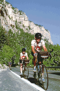
For this month's road climb, I have moved south to Cedar City. After the cycling events at the Utah Summer Games were finished, I took the opportunity to ride up Cedar Canyon, a beautiful climb and a personal favorite.
The weather this year had been wet and cool. I awoke early for this ride, worried that precipitation would spoil my plans. Fortunately, though cool and cloudy, it looked as though I could slip in a couple of hours before any rain arrived.
I started my ride at the corner of Center and Main in Cedar City. Climbing begins immediately, albeit gradually, and within a mile you are in Cedar Canyon, aptly named as you gaze at the cedar trees coating the canyon walls.
At mile 4.9 is Right Hand Canyon, the first 4 miles of which is the Utah Summer Games hellacious hill climb. I was glad to be riding past it this morning, not up it. At 7 miles, the creek crosses under the road as you look at protruding vermillion cliffs topping a side canyon to the left.
This is where the serious climbing starts. The road ascends steeply for the next 4 miles. (Actually, it ascends for the next 8 miles to Webster's Flat, but the 4 miles just ahead are the toughest.) Within the next mile, you climb from creek level to a point where you peer down at the creek flowing along the canyon floor far below.
Halfway up this one-mile stretch, you can see where the canyon splits. The main creek flows in from the left and a smaller creek from the right, with three massive stone bulwarks framing these creeks just before they join.
 The road turns sharply at mile 8.3, climbing alongside the smaller creek and up the canyon to the right. This is the point where the cedars end and the pines take over. I was struck by the pristine beauty and fresh, moist scents as I rhythmically wound my way upward through this lush canyon. I was also starting to get a little chilled.
When the canyon starts to open up at mile 10, it gives the false feeling that the steep pitch is going to ease. Do not be deceived. Though the canyon does widen into a lovely panorama of pines, aspens and open meadows, the road continues to climb steeply.
I was able to gear up one gear for about a half mile as I rode past the Southern Utah University Mountain Center and on up to Iron County's Woods Ranch Recreation Area. At this point, I had to drop it back down into my easiest gear as the road visibly steepened.
Past Woods Ranch, you are back into heavily wooded area, with the pines forming columns on either side as you climb. Finally, there is an S-curve at mile 12.7. On the reverse stretch of the S-curve, I gazed down at the canyon I had been ascending. I always enjoy these vistas that allow me to see what I have been able to accomplish.
At this point, the fatigue from 3 days of racing was catching up with me. On top of that, it was starting to get cold. Still, the driving force behind riding a climb is to reach your destination, and I was determined to press on.
I was further bolstered as I turned the second half of the S-curve and could see, way up to the right, the notch through the ridge that I knew marked the point where the steepness eased somewhat. The thought of soon being able to spin it out a little bit in a bigger gear is always good incentive for me.
It is also at this point that you view straight ahead some majestic cliffs and pinnacles of various shades of orange jutting out from the surrounding greenery. This is not Cedar Breaks, but a taste of what the national monument will bring.
The road winds upward along the left side of the canyon, curves around the end of the canyon, and ascends to the notch through the ridge. You have now reached Webster's Flat at mile 14.8, and the toughest part of the climb is behind you.
The road now rolls along the north slope of the mountain, still always climbing but not quite so steeply. I always enjoy this section because of the sweeping panoramic view to the south.
There are several places along this stretch where the unhurried cyclist can stop and feast on the view of Zion National Park in the distance, and the basin leading down to it. A must stop is the scenic turnout at mile 16.7 with the descriptive placard pointing out the various features of the landscape.
A half-mile later brings a temporary end to the climbing as the road begins to descend. At this point is located the Bristlecone Pine Trail. These tough, weathered and aged trees are a marvel, and this short hike is highly recommended.
As for me, I was definitely cold at this point, and the clouds were looking heavy with moisture. Also, during the last several miles of my upward climb, I had observed the snowfall of the last two days, a wet, white covering on the pines and ground. So, I passed on the hike and enjoyed the brief one-mile descent to the turnoff to Cedar Breaks (mile 18.1).
After this turn, the road climbs again. It looks long and steep as you head upward, but don't despair. Though the sign says 4 miles to Cedar Breaks, the initial climbing only continues for a mile. Then, the road consists of mild pitches accented with short, somewhat steeper sections till you reach Cedar Breaks at mile 21.7.
The Cedar Breaks visitors' center is a definite stop. In addition to information on the landscape and geology, you have a beautiful view.
From here, there are several options. If you have had enough, this is where you head back down. It is a fun descent, a well-earned reward for all your hard work in getting here.
(For me, I feared I was going to freeze. I was soaked from perspiration, and was certain the descent was going to be miserable. Fortunately, I had brought my rain jacket along. So, I put it on and enjoyed a relatively warm descent down to Cedar City.)
Or, you can continue onward. The road continues to roll along till it reaches the summit at 10,400 feet. (Cedar City is at 5,500 feet, so there is nearly 5,000 feet of climbing). There are also additional stops along this section for enjoying Cedar Breaks' beautiful vistas.
From the summit, you descend into Brian Head and on down to Parowan from where you will loop on back to Cedar City (total mileage approximately 75 miles).
If you enjoy a good climb, I highly recommend this ride. It is definitely one of the more scenic and the road is excellent. It is long, but then that only makes the enjoyment of the descent last even longer. Gear it low, and have fun.
Editor offers a climb to the top of the Uintas
By Robert L. Truelsen, Editor
I hadn't really thought about participating in Publisher Dave's climbing series until I went to cover the High Uintas Classic on June 21 with its featured climb over 10,700-foot Bald Mountain Pass.
I was freezing my saddle off waiting for racers to claim their KOM and QOM prizes when I decided to contribute a worthy climb to his series.
The High Uintas Classic continues to be on my short list of favorite races from both a jounalist's and racer's point of view. I participated in the first couple of events and it was during this race that I clocked my fastest descent ever on a bicycle: 54 mph (pretty fast for a skinny guy).
I've made the climb from the Kamas side but how about from the Evanston side, the reason for my fast descent.
So just before the Bear River Station, I stopped and watched the categories move onto the flats and wind that make this road race such a tough stage.
I pulled off within sight of the 46-mile road marker near Stillwater Campground in an area called Christmas Meadows. Most of the descent was behind the racers at this point with a few rollers left before the flats entering Evanston.
The pass wasn't in sight at this point but the beautiful Uinta Mountain range provides plenty of breathtaking scenery. To race in the Uintas is exciting, to be sure, but to tackle the ride without the pressure of competition is the best way to enjoy the view.
The road through the aspen for the first few miles provided several easy inclines for a good warmup. The road was fairly straight with only a few bends. The fresh, new growth of the aspen provided a colorful hallway on the way up. The road continued with gentle rolling hills until around the 36-mile marker when I started reaching for easier gears to get up a couple of good inclines.
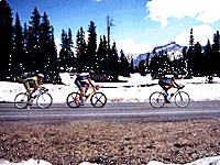
One mile down the road at the 35-mile marker, I reached snow level. Race organizer Paul Knopf was grateful the pass was opened about 12 days prior to the Bald Mountain Road Race, but there was plenty of snow still along the road. The road made a steep pitch up to one of the many lakes in the Uintas, Butterfly Lake.
The road then seemed to level as I shifted into the big ring to take advantage of the opportunity to spin my legs out.
But this spin was brief as the road made its way to Fehr Lake. As the road rounded a bend near the 34-mile marker, Hayden Peak loomed straight up the road, providing a wonderful backdrop for this hard workout.
The climb seemed more like a staircase with its periodic steep pitches followed by slight leveling which provided a much-appreciated break.
Then it was down to and then up past Mirror Lake, the popular fishing/sight-seeing point. The summit wasn't far and that fact helped get me over the top. The climb was constant now and its only variance was in the degree of the slope.
Water was running across the road, fresh snow melt, as I reached the switchbacks near the top. The road is at or near the 10,000 foot mark but I didn't seem to have trouble getting enough oxygen. Good thing I wasn't racing, another reason to enjoy being a recreational cyclist these days.
As I approached the summit, the snow bank along the road was still handlebar high. Riding the white line, I was inches away from the snow. The experience reminded me of the photos taken during the Giro de Italia stages over the Alps and Dolomites with racers dwarfed by massive snow banks along the road.
I reached the summit and mile marker 29. Ten thousand, seven hundred feet above sea level and the view from the top was ample reward for the hard work getting there.
At times I miss racing, especially while covering races. But then there are moments like this that remind me that racing is only a small part of our sport. The real benefit lies in just going out and riding for the pure enjoyment of it along some of the scenic byways of our state.
I soft pedaled a bit on top but the wind reminded me I was in shorts and short sleeves, sweaty and about to descend from the summit. I looked back over my shoulder for one last look before addressing the descent of my record book.
But I wasn't worried about surpassing my record, there was too much to see on my way back to the car.
 Return to July index