cycling utah July 2000
Diamond Fork keeps you coming back for more
By Greg Bromka
Diamond Fork is off the beaten path and easily overlooked, but the word is out that this is the place if you're a singletrack purist. Tucked in the Wasatch hinterlands, Diamond Fork's rolling forested hills obscure most views of the Wasatch Range. That is unless you make the climb to Strawberry Ridge, from where the serrated Wasatch can be seen stretching over 60 miles from the Alpine Ridge (Little Cottonwood Canyon) to Mount Nebo. So carry a camera just the same, preferably one that takes panorama format pictures.
"Go back to that part about being a singletrack purist," you say? This near marathon-length ride is over 60-percent twisty one-laners. The four trails this loop ties together are sometimes-forgiving, sometimes-technical, and always big fun. You'll splash through creeks, dodge rocks, duck under trees, and test the performance of your tires' traction and your brakes' grip.
But wait, there's more. Pack along a bathing suit because you'll want to soak your weary legs in the natural hot springs in lower Fifth Water Creek near the trail's end. The Diamond Fork loop is as yummy as Lay's Potato Chips(r)-bet you can't ride it just once.
Notes on the trail
From the Three Forks parking area, cross the narrow footbridge over Diamond Fork then cross a second footbridge over Sixth Water immediately to the right. Step across Cottonwood Canyon Creek (no footbridge) and you're on your way.
Cottonwood Canyon Trail is moderately strenuous and moderately technical with a few more-demanding sections thrown in for good measure. The original path crossed the creek several times; now you'll find cheater routes that keep you high and dry. After passing the signed junction for Jocks Canyon the unmistakable odor of sulphur announces the presence of natural hot springs. Ride through a clearing alongside a wire fence then take the pebbly road uphill for 1 mile to paved Rays Valley Road.
Turn left, ride up and over a hill, and then turn right for Second Water Trail, Strawberry Ridge, etc. After 1 mile of relative ease, the path bends north to continue up the hollow but at a more taxing grade. Cross the creek bed several times and drag your bike up a steep stretch that is chock-full of rocks.
At the signed junction for Center Trail No. 009 (left), stay right/straight toward Indian Spring and Strawberry Ridge. The singletrack widens to an ATV track and rises gently through aspens and conifers that offer comforting shade because you'll be sweating buckets by now. When you reach Strawberry Ridge, take the doubletrack (Forest Road 135) left/north and up the first of five climbs to come. Just grin and bear it knowing there is a turbo-charged descent offsetting each climb.
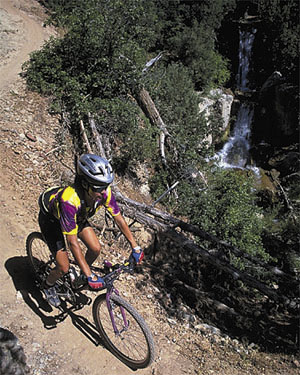
After 5.5 miles along the ridge, watch for Forest Road 110 branching right/east at the bottom of a high-speed hill. Continue straight on the ridge road for .5 mile, and at the base of the next climb fork sharply left onto the unsigned upper Fifth Water Trail, which begins as an ATV track. Whip through the turns, dodge tree limbs, descend off a subtle ridge into the head of Fifth Water, and continue dancing down the canyon on tight singletrack. Pass two junctions for the Center Trail and duck into shady cottonwoods. What a rage! Finally, the sweet singletrack crosses the creek once more and joins a doubletrack which intersects Rays Valley Road. Cross the pavement and continue on lower Fifth Water Trail, but be alert to several sections that redline the pucker meter.
Pass a double-decker waterfall then a second cascade that announces the famed Fifth Water hot springs. Soak your bones and culminate the tour on a wide, splendid path along the wooded creek and beneath rudy cliffs to return to Three Forks. (Be alert and courteous to other trail users; this route is popular.)
Intermediate-level bikers should not write off Diamond Fork because of the long miles and daunting trails. Simply ride the 16-mile "inner loop." Take the Cottonwood Canyon Trail as described to Rays Valley Road. Instead of heading up Second Water Trail to Strawberry Ridge, ride Rays Valley Road 5 miles northward-up and down several hills-to the Fifth Water Trail junction. (Look for a stop sign on the left side of the road at the bottom of a screaming descent.) Finish the loop by descending lower Fifth Water Trail past the hot springs. (Be ready to dismount for a few scary sections.) Ride this loop once and you'll return time and again.
Just the facts
Distance: 24-mile loop.
Tread: Singletrack and ATV trails vary from silky to pebbly to semi-primitive; doubletrack on the ridge is sometimes rutted; a touch of pavement is required. Cattle are herded to and from range lands along these trails seasonally; their impact can be noticeable. Contact the Spanish Fork Ranger District to learn where cattle are being ranged and when they are being moved.
Aerobic level: Strenuous. The route begins with nearly two hours of climbing to Strawberry Ridge. One-half dozen short, steep ascents punctuate Strawberry Ridge; each is offset by a blazing downhill. The route culminates with a seemingly endless descent.
Technical difficulty: Moderate. Cottonwood Canyon and lower Fifth Water Trails are packed dirt with loose stones. Second Water and upper Fifth Water Trails are traveled less frequently, so expect quasi-primitive conditions. The Strawberry Ridge road is packed dirt with variable rocks and ruts. There are a few highly technical sections on lower Fifth Trail where the path is rocky and clips the edge of steep slopes.
Elevation change: The trailhead is the lowest elevation at 5,520 feet. Strawberry Ridge undulates between 8,400-8,700 feet. Total elevation gain is 3,800 feet.
Trailhead Access: From I-15, take Exit 261 for US 6 and Price. Five miles up Spanish fork Canyon, turn left/north for Diamond Fork (between mileposts 183 and 184). The Three Forks parking area is 10 miles up the paved Diamond Fork road and accommodates up to a dozen vehicles.
Excerpted from Mountain Biking Utah, 2nd Edition 1999, by Gregg Bromka.
 Back to Home Page