By Don Scheese — As the spread of the COVID-19 novel coronavirus grew from an epidemic to a pandemic, as the number of cases of the virus and deaths grew exponentially and the phrase “flattening the curve” came into vogue, and as the stock market crashed, I knew I had to retreat from the tidal wave of bad news to my time-honored sanctuary: the great out-of-doors.
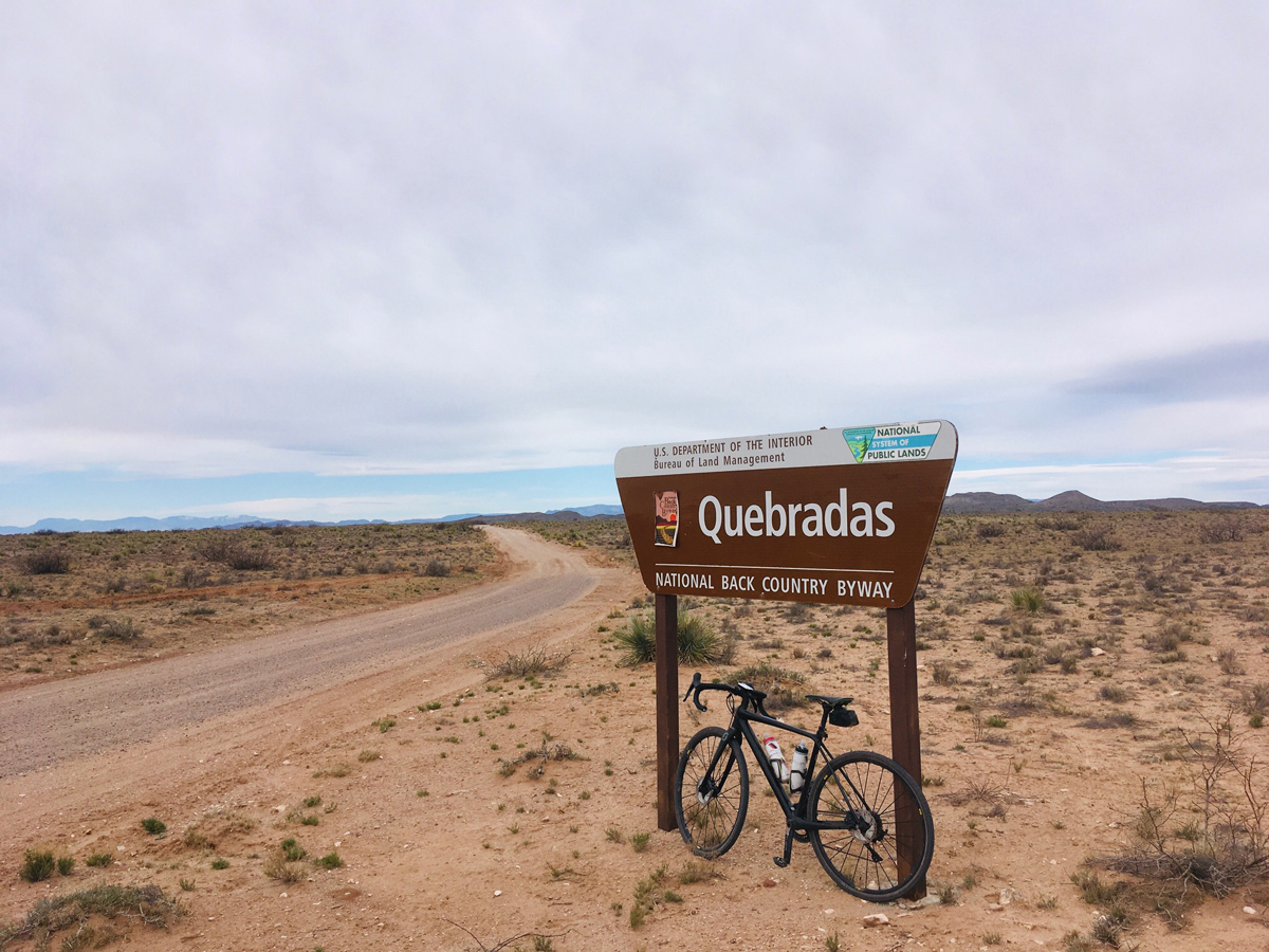
But where to go? I’d read an article in the local newspaper about the Quebradas Backcountry Byway, a BLM road east of Socorro in central New Mexico, that sounded intriguing. Quebradas is Spanish for “breaks” or badlands, and the byway promised some fascinating geology. More importantly at a time when “social distancing” was all the rage, it offered at least the hope for plenty of solitude. As a self-proclaimed misanthrope who normally cycles, hikes, and camps alone anyway, I looked forward to the 24-mile stretch of gravel sans motor vehicles, with expansive views, and the three most important elements of any outdoor excursion: Quiet, Solitude, and Wildness.
My plan was to do this as a 2-day trip, hopefully car-camping somewhere around halfway, cycling back to the start point then returning to the car; then cycling the second half of the road the next day and again returning to the car. So essentially, I’d ride the byway twice, getting a real feel for the terrain and seeing it from both directions. I wasn’t sure about how much elevation I’d be gaining and losing, but, as it turned out, I’m glad I approached the trip conservatively.
Day 1
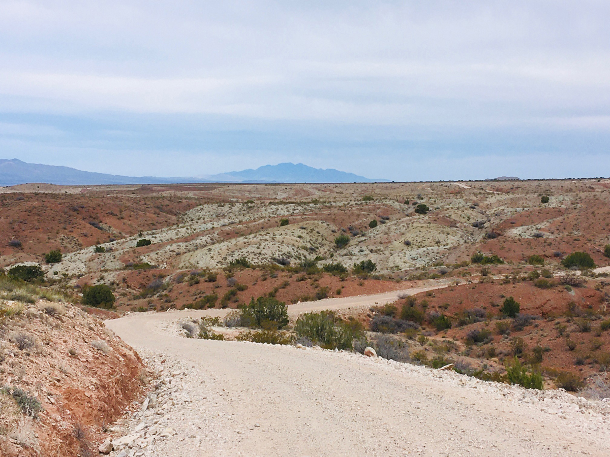
The northern end of the Quebradas Backcountry Byway lies just north and east of Socorro. Once off the interstate, the approach is through some typical rural New Mexico communities consisting of dilapidated double-wides, crumbling adobe pueblo style homes, flowing acequias, grazing animals, and barking dogs. Just past the village of Pueblito the Byway officially begins and immediately starts climbing from the Rio Grande valley to the mesas and bajadas of the interior mountain ranges, in this case the low mountain range poetically labeled (like so many New Mexico landmarks) Lomas de las Canas—“the hills of the white hair”—named (I came to speculate) for the ocotillo forests on top of the white limestone ridges.
Every cyclist knows that it’s one thing to drive a road, quite another to ride it on your bike. Ernest Hemingway once wrote, “It is by riding a bicycle that you learn the contours of a country best, since you have to sweat up the hills and coast down them.”
As I drove my Subaru Crosstrek at a safe and sane 25-30 mph on the relatively smooth gravel road, pausing along the way to check out possible campsites, I took note of the many arroyo crossings but failed to truly appreciate how steep some of the climbs out of them would be on a bike, especially with rocky and loose gravel to contend with on the ascent. I noticed numbered signposts along the way (the New Mexico Bureau of Geology and Mineral Resources has published a Geology Guide to the Byway, downloadable from the agency website here: https://geoinfo.nmt.edu/publications/guides/quebradas/home.html).
Happily, I passed but one human inhabitation: the Four Hills Ranch around which were the usual NO TRESPASSING signs and the ubiquitous barbed wire fence strung out along the property. Mostly I just gawked at the endless expanses of creosote and mesquite flats, the deep red sandstone outcroppings, and the soft white limestone hills rising on the eastern horizon
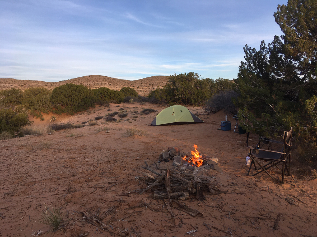
I drove by a few passable campsites but, recluse that I am, preferred a more secretive, sheltered site. At mile 12, I stopped at the deepest, widest arroyo crossing yet, the Arroyo de las Canas, a veritable barranca, and seriously wondered if I could ride my bike out of it. On the opposite side lay a flat juniper-dotted bench that looked promising and, at mile 13, sure enough, a well-traveled spur road took off to the west where, a couple hundred yards later, lay the perfect site: flat, sandy, sheltered, with an impressive and apparently well-used fire ring already set up. Not to mention good views of the Lomas de las Canas to boot. Giddyap!
Quickly changing into my cycling gear, stuffing my jersey pockets with fruit chews and bars, topping off my 2 water bottles with water and energy drink, and being sure to take an extra spare tube, I hopped onto my trusty Scott Addict gravel bike.
The first challenge would be the climb out of the Arroyo, but at least I’d be taking it on with fresh legs. I coasted down then dropped into the bottom of the arroyo, noticing ponds of water amidst the willows, remnants of recent spring rains. I quickly shifted into my lowest gear—thank gawd for the 1:1 ratio of 34-34—and trundled my way up the incline, which at its steepest measured up to a 15% grade, confirming the real meaning of the term “gravel grinding.” I made it without stopping and was rewarded with fine views from the mesa top of the distant snow-capped ranges to the west: the San Mateos and Magdalenas, topping out at over 10,000 feet.
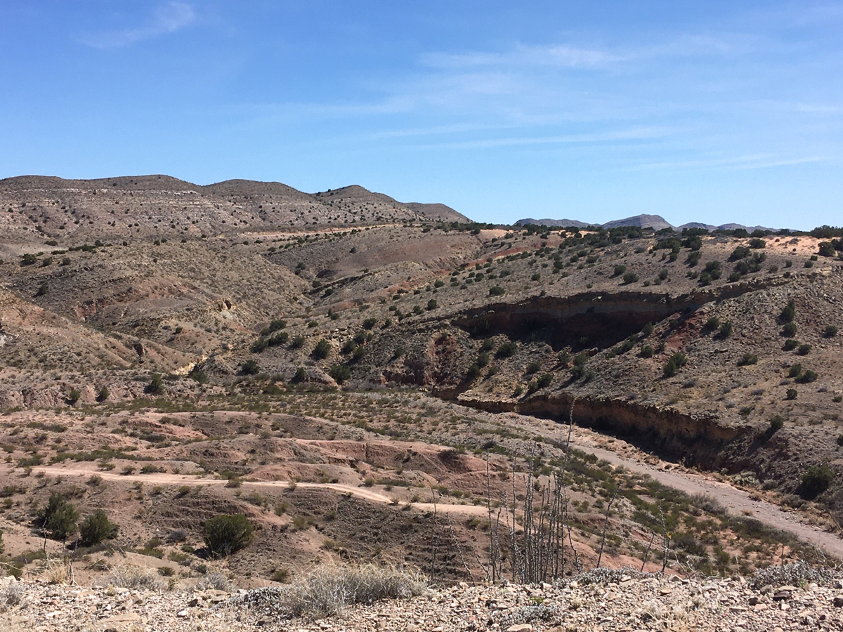
The next 12 miles consisted of endless rollers through a kaleidoscope of colors: deep reds of the Abo sandstone, pale yellows of the Yeso limestone, and the dark volcanic outcroppings of the more recent Baca era. I crossed three more substantial arroyos (fortunately none as deep as the Arroyo de las Canas) and enjoyed a nice tailwind across a relatively flat stretch of road passing through the landholdings of the 4 Hills Ranch. Most of the way it was nothing but creosote and mesquite, the sole surviving vegetation in some of the most cow-burnt landscapes I’d ever seen. The shadow of a lone turkey vulture soaring above drifted silently over me, and I started to hear the theme song from The Good, the Bad, and the Ugly in my head. “What beautiful desolation!” I thought to myself.
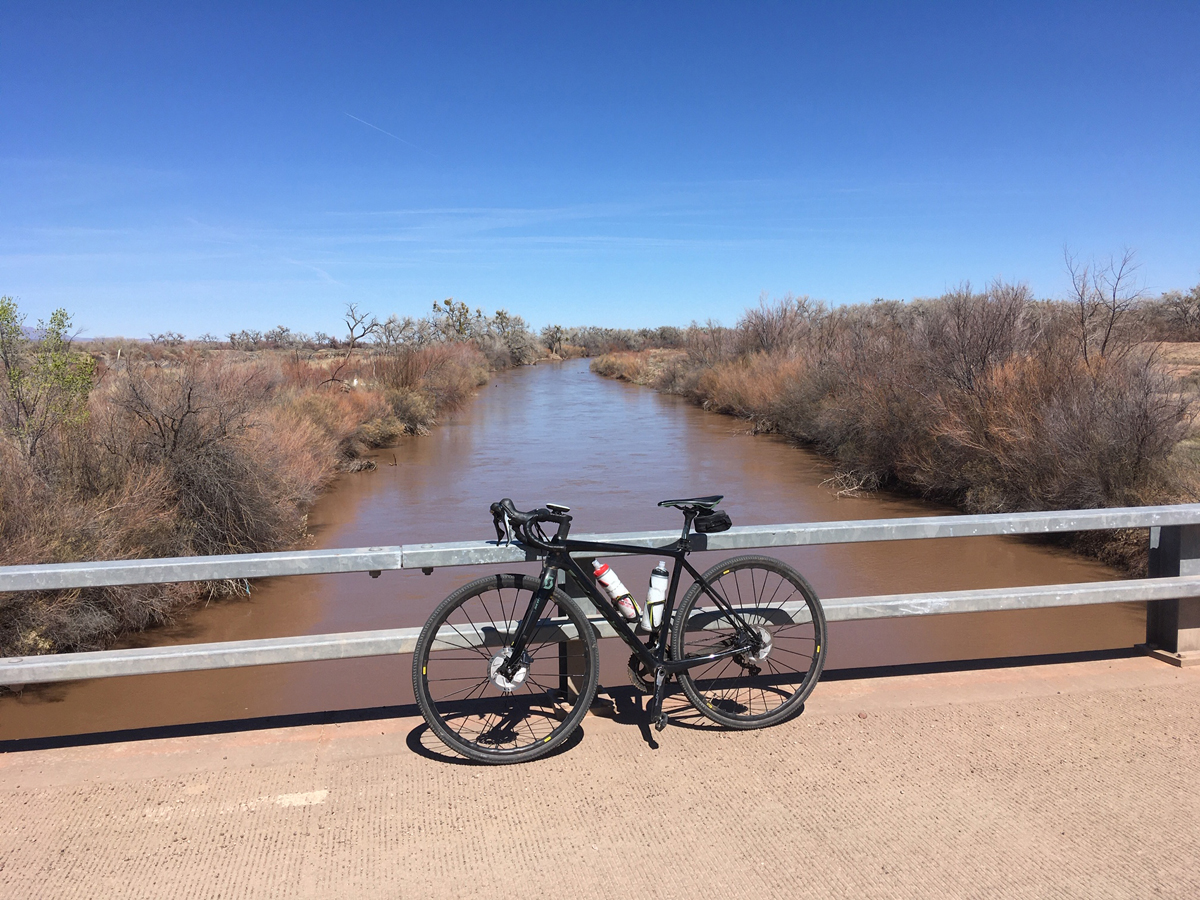
Around 3 miles from the northern terminus of the byway I had the best view yet of the soft pastels of the Rio Grande valley, the silvery cottonwoods with just a tinge of spring green in the bosque. After bottoming out and reaching the end of the gravel road, I decided to ride through the village of Pueblito to the river crossing, making better time than I wished, after being chased by some unleashed dogs—unsurprising, because who leashes their dogs out in the countryside? At the crossing I ate, drank, and watched the big brown god of a river—Rio Grande indeed!—purl under the bridge. The first half of today’s journey was complete, and utterly gratifying.
The return trip proved to be much more challenging. Not only did I ride into a stiff 10-15 mile an hour headwind, there was much more climbing involved (1800’ compared to 600’). Once again, confirming the true meaning of ‘gravel grinding.’ But I managed just fine, taking the occasional break at the top of a pass to rehydrate, eat, and snap the occasional photo. Mercifully, the reverse climb out of the last big arroyo before the turnoff to my campsite was nowhere near as steep as the south-to-north approach, and by the time I made it back to camp and the vehicle it was late afternoon.
I’d encountered only four vehicles, two the same rancher apparently hunting down some stray cattle, the other two some fellow ‘social distancers.’ Other than a friendly wave to the rancher in his pickup there’d been no interaction with a member of my own tribe, which I found both physically and mentally beneficial. I celebrated with hot dogs grilled over a fire, some ranch beans, and a nice cold Fat Tire ale. I’d brought some firewood from home but there was plenty more scattered about and enjoyed hours of sitting around the campfire ruminating on my solitary state.
A poem by Robinson Jeffers came to mind, in which he reflects on a special spot of his on the California coast: “This place is the noblest thing I have ever seen. / No imaginable / Human presence here could do anything / But dilute the lonely self-watchful passion.”
I raised a flask of whiskey to all my heroes of solitary celebration, long before the term ‘social distancing’ came into being: Thoreau, Muir, Abbey, Jeffers.
Quiet. Solitude. Wildness.
Day 2
Awaken to milky skies and mild temps. A small warming fire and hot coffee to start the morning…followed by a sumptuous breakfast of scrambled eggs and home fries, bacon, and sausage, all slathered in salsa. Breakfast of champions.
On the bike hours earlier than yesterday, anxious to explore terra incognita—the un-reconned road ahead. I figured I’d have around 11 miles today, with less climbing to reach the end of the byway, and with calm winds to start, and maybe even a tailwind on the return, an easier ride—and I was right.
Heading south, I discovered later I had been straddling the border between the boundaries of a small Wilderness Study Area (WSA) proposed by the BLM—appropriately named the “Sierra de las Canas.”
According to one writer it contained the remains of an ancient Piro Indian pueblo, a rare prehistoric rock art panel, and several petroglyph sites, somewhere out there amidst all the blank desolation. Like any intriguing landscape, this is worth coming back to for further exploration.
The next couple miles called to mind some Georgia O’Keeffe paintings, soft reds and yellows horizontally streaking yet more badlands—layers of the Meseta Blanca formation. Through these strata the road dove and rose across five deep arroyos, one of which required me to hike-a-bike after my front wheel washed out in some loose chunky gravel. Oh well, no hurry on a still quiet solitary morning. In fact, this was a day of ultimate social distancing: I encountered absolutely no other human beings in 23 miles of riding, and heard hardly even a bird chittering from the creosote flats. A day of Quiet, Solitude, and Wildness.
The byway took a sharp turn to the northeast down into another arroyo, then a long gradual ascent up the same major drainage, to its head and the high point of the entire ride at 5400’. At this gap I met with my first and only sign of livestock, a small group of cattle feasting at a water tank, salt lick, and piles of hay. A backward glance over the road just travelled revealed fine views of the snow-capped Magdalenas through a gap in the cliffs.
The last three miles entailed a shallow descent to the official end of the byway. A couple miles of flat ranchland road stretched to the junction with Highway 380. The views to the south of the prominent cone of Cerro de la Campana, the Oscura and San Andres ranges, and the northern end of the Jornada del Muerto were enticing, but I had miles to go to return to the car as well as promises to keep, and reluctantly but happily turned around to ride the reverse route.
Back to the car, blessed with a welcome and increasing tailwind from the south. 23 miles roundtrip and 1800’ of total elevation gain for the morning—a good day’s ride for me.
Followed by a smooth drive home and a return to an ever-worsening pandemic, the whole trip served, as Robert Frost said of poetry, as a “momentary stay against the confusion.”
If You Go…
Check with the BLM office in Socorro about road conditions; the all-gravel road is graded occasionally. Do not ride immediately after substantial rains as the road becomes impassable. Riding from south to north is easier, as you start at around 5000’ and finish at 4600’ in the Rio Grande valley. I rode on 36 mm tires with good tread and would recommend at least a 35 mm tire for the loose gravel sections climbing out of the arroyos. Come prepared for a long ride and unexpected emergencies and do not expect to be bailed out as there is usually little traffic.
The best seasons to ride are spring and fall when daytime temperatures are more moderate and precipitation chances decline significantly. Dispersed camping is allowed along the byway but there is no water or bathroom facilities. Celebrate with a beer and a world-famous green chile cheeseburger at the Owl Café afterwards in the village of San Antonio near the southern terminus of the Byway.
Don “Seldom Seen” Scheese lives and rides in New Mexico, always in search of new adventurous routes, especially on gravel roads.