cycling utah April 1999
Bartlett Wash and Klondike Bluffs will draw you deeper into redrock country
Click here for a Topo Map of this trail
By Gregg Bromka
Excerpted from Mountain Biking Utah--Revised 2nd Edition (publication date May 1999), by Gregg Bromka.
Bartlett Wash and Klondike Bluffs might be considered the introductory rides to the Moab area: Both offer a sampling of the varietal riding mediums throughout the region, from doubletracks to slickrock. Each is blessed with captivating scenery that draws you deeper into this redrock Mecca. And they are a pair "gateway" trails, the first riding opportunities after turning off Interstate 70 on your final approach to Moab. If Klondike Bluffs and Bartlett Wash raise your brow, then you will be primed for happy times ahead. Conversely, if either proves a bitter pill to swallow, then plan on spending more time on a bar stool than on your bike.
Notes on the trail
Bartlett Wash:
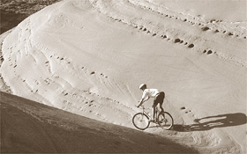
Not all slickrock is created equal. The Bartlett Wash slickrock is a member (or subdivision) of the Entrada Sandstone, which forms the wonderful creations that give Arches National Park its name. The Slickrock Bike Trail, the standard by which all slickrock is compared, is composed of older, stratigraphically lower Navajo Sandstone. Like Slickrock's Navajo, Bartlett's Entrada provides superb traction. But unlike the Navajo's pale buff color, the Entrada's salmon-hued shade delights the eye like the warmth of the setting sun on a hazy eve.
From the fence that crosses Bartlett Wash, go right toward the old cottonwood, cross the micro-meadow, and push up the slickrock access ramp. Pedal southward and within 0.5 mile trudge through a long sand trap; then hop back on the rock. Continue southwestward beneath the ledge on your right, which is capped with sandstoned elephant toes.
You're on your own to construct a feasible route; there are no paint-on-rock dashes to guide you. Improvisation leads to hours of mountain bike gymnastics. There are numerous arcuate bowls to surf, solution pockets to dodge, and protracted slopes to test muscle against balance against the coefficient of friction. Just remember to keep your wheels on rock and away from pothole gardens.
About 1.5 miles out, the lens of slickrock wraps around the mesa's abutment, and Hidden Canyon cuts in from the west. The route ends 0.5 mile farther, where broken cliffs plunge to the valley floor. Turn around and retrace your tracks, or follow your bliss--diving, dodging, and feeling free on two wheels.
Klondike Bluffs:
Klondike Bluffs is a primer for canyon country scenery. At midroute, you climb an inclined slickrock ramp and pass imprints of three-toed dinosaurs that tramped across mud flats and river bottoms about 170 million years ago. At route's end, you can hike across the trail's namesake bluffs, which have eroded to billowy bonnets, fractured fins, and darkened alcoves. Features of Arches National Park can be seen in the distance, backed by the stoic La Sal Mountains.
From the roadside parking area, take the main dirt road northeastward across the badlands. After 2.5 miles, the road descends gently to a large junction in a broad valley. Stay left, cross the clearing (an alternate parking area for novice riders), and cross a wire fence. Angle northward on the sandy doubletrack up Little Valley. Cross the wash; then at a T junction fork right following trail markers. Klondike Bluffs peek through a notch on the skyline. After entering a dry wash lined with sandstone ledges, you pass a small alcove on the right that resembles Fred Flintstone's front porch.
Now 4 miles out, you hit a slickrock ramp. There is plenty of play room but you'll find the only navigable path is to the far left where the sandstone laps against the ledgy bluff. Just follow the three-toed footprints painted on the rock. Near the top of the ramp, you pass imprints in the stone made by the real prehistoric beasts.
Round a ledgy point marked with a huge rock cairn that serves as your beacon on the return leg, descend a bit then veer right onto the slickrock ribs. If you don't follow the route markers carefully, you'll end up on the wrong rock rib and have to cross fragile garden areas to get on track, and that's bad form.
Nearing a band of low cliffs, the route veers south and ends at the signed boundary for Arches National Park. Take a hike, literally, because bikes are not allowed beyond this point. Walk as far as you desire or until you are rimrocked. The view of Klondike Bluffs at your feet, expansive Salt Valley beyond, and Arches in the distance makes choking down an energy bar and swilling warm carbo juice a five-star dining experience. Return to the trailhead by retracing your tracks.
Just the facts:
Bartlett Wash
Distance: 4.2 miles out-and-back.
Tread: Slickrock throughout except for one short sand box.
Aerobic level: Moderate. You can spend hours exploring every nook and cranny and pitting your fat-tire savvy against the rock. Your legs will tell you when it's time to go home.
Technical difficulty: Moderate. Technical difficulty is directly proportional to the extent you defy gravity and experiment with traction.
Elevation change: The trail gains merely 400 feet from its 4,620- foot trailhead to the turnaround. But because of the route's freestyle nature you can expect to gain double.
Hazards: Bartlett Wash's main attraction, slickrock, doubles as the route's greatest peril. The sandstone's smooth surface and swirling, platy crossbeds can provide excellent traction--or lack of traction--depending on how it's exposed. Be prudent when pursuing "Zen and the Art of Fat-Tire Friction."
Getting there: From the intersection of Main and Center in Moab, drive 17.2 miles north on US 191 and turn left on Blue Hills Road, near milepost 143. (Blue Hills Road is 14.5 miles south of I-70.) Take the light-duty dirt road (impassable when wet) 2.2 miles and fork left. At a second junction 0.8 mile farther, stay left/straight and come to a deep sandy section. Scout the sand to determine if your vehicle can cross it.
If not, park and embark. If you cross, go up the small hill, fork right, and drop to Bartlett Wash. The trail begins about 1 mile south at a fence marked by an old cottonwood and small grassy meadow.
Klondike Bluffs
Distance: 15.2 miles out-and-back.
Tread: 2.9 miles of light-duty sand and dirt road; 4.7 miles of sand and rock doubletrack, including slickrock.
Aerobic level: Moderate. The route is mostly uphill on the way in, but reserve some juice for a few "bumps" on the way out. Budget extra time, energy, water, and food if you choose to hike out Klondike Bluffs beyond the route's turnaround.
Technical difficulty: Moderate. Light washboards are followed by sand and rock doubletracks, slickrock, and more bumpy doubletracks.
Elevation change: The route rises from a trailhead elevation of 4,520 feet to 5,360 feet at the turnaround at the Arches National Park boundary. You'll climb a bit on the way out for a total gain of about 1,250 feet.
Hazards: Always watch your front wheel and nearby terrain changes when riding slickrock exposures. Use caution if hiking from the trail's end out across Klondike Bluffs (proper) in Arches National Park; the informal route requires scrambling over slickrock and skirting edges of cliffs.
Getting there: From the intersection of Main and Center in Moab, travel 16.5 miles north on US 191. From I-70, travel 15.1 miles south on US 191. The dirt parking area is on the east side of the highway next to a gated wire fence (keep closed) between mileposts 142 and 143. Novice riders might opt to drive the first 2.6 miles to an alternate parking area.
 Back to April 99 Cover