cycling utah April 2000
Gemini Bridges keeps you coming back for more
By Gregg Bromka
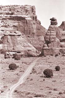
Gemini Bridges is one of those routes that everyone loves to ride time and again, especially if you're not hellbent on pitting testosterone against Slickrock or stamina against epics. It's one of Moab's "easiest" routes (an oxymoron?) because it's largely downhill. However, it's nary a cruise through the park because the sometimes-rough doubletrack works your arms and the mile-long climb out of Little Canyon is a little devil. But the sweeping panorama of Monitor and Merrimac Buttes to the north, Gold Bar Rim to the east and the La Sal Mountains and Behind the Rocks to the southeast outweigh any hardships endured.
What makes this route unique is that it places you on top of the namesake arches rather than making you crane your neck skyward from underneath. In fact, it's easy to pass right by the bridges unknowingly. The fun comes when you step out on to their flat tops and peer into the acoustically resounding alcove below. Acrophobes might want to stay on the mainland. Later, the route wanders up the hanging valley of Little Canyon and to the rim of orange-brown cliffs that overlooks Moab Canyon and Arches National Park beyond.
Notes on the trail: You'll need a shuttle to reach the upper trailhead off UT 313 en route to Canyonlands National Park's Island in the Sky District. (Moab taxi services or bike shops can offer a lift - for a price.)
Head east through juniper and pinyon chaparrals and let gravity slowly pull you down the bumpy double-track. Ever-widening gaps in the earth's crust off to the right remind you that this is indeed canyon country. Descend a bit faster, and after 4 miles stay straight at a junction for Arths Pasture (left/north); then stay straight again farther on bypassing the spur to Four Arches Trail and Crips Hole (right/south). One mile more, fork right to access Gemini Bridges. Keep on the straight and narrow by following the painted markers to avoid trampling the delicate desert crust.
You could practically roll right across the flat-topped connectors without knowing it, except that the earth drops abruptly 200 feet into the boxed-in canyon. Bask on the rock like a lizard then yodel into the canyon and catch the reverberations.
Backtrack to the main junction and head right/east. At a prominent junction 1 mile ahead, fork left to descend a steep hill laden with sand, loose rock, and ledges. (Fork right to venture up Bull Canyon and view Gemini Bridges from below.) Stay left at the bottom of the hill to head up Little Canyon, slogging through sandpits, and tipping your helmet hello to the Gooney Bird formation. About 1 mile past the sandstoned cuckoo, the canyon widens and the road starts rising, gradually at first then at a rather rude incline. Just when you think you've made it to the top, the road curves and rises up one last pitch.
The descent on the sand, rock, and rutted doubletrack is as fast and fearful as you dare make it. But if you work the brakes you can enjoy the stunning view from the cliff's edge of the valley below and of arches dotting the distance. (Be alert to uphill bikers who have opted to ride out-and-back.) Finally, follow the power lines to the lower trailhead.
No shuttle? No problem. Park and embark from the lower trailhead and ride 15.5 miles out-and-back to Gemini Bridges. This option is moderate to strenuous because it's mostly uphill to the bridges. Plus you'll face that little bruiser of a hill on the way back. Total elevation gain is nearly 1,300 feet.
Just the Facts:
Distance: 13.7 miles.
Tread: Rock-studded and sand doubletracks.
Physical Difficulty: Easy to moderate. Easy cruising until you start sucking air while climbing out of Little Canyon.
Technical Difficulty: Low to moderate. Suspension goes a long way to smooth the jackhammer conditions from the outset, but not every pitching wedge can get you through some of Little Canyon's sand traps.
Elevation Change: The upper trailhead is at 6,000 feet. The lower trailhead is at 4,575 feet. The 300-foot climb out of Little Canyon awakens your legs and lungs.
Trailhead Access: From the intersection of Main and Center in Moab, travel 10 miles north on US 191 to the marked trailhead next to the railroad tracks. Drop one vehicle here; then drive on US 191 for 1.2 miles and turn left on UT 313 for Canyonlands National Park and Dead Horse Point State Park. Drive 13.2 miles to a dirt road on the left tagged for Gemini Bridges between mileposts 10 and 9.
Excerpted from Mountain Biking Utah, 2nd Edition 1999, by Gregg Bromka.
 Back to Home Page